WPAC: RAMMASUN - Post-Tropical

Moderator: S2k Moderators

Message
Author
dexterlabio
Category 5
Category 5
Posts: 3406
Joined: Sat Oct 24, 2009 11:50 pm

#21 Postby dexterlabio » Wed Jul 09, 2014 2:19 am

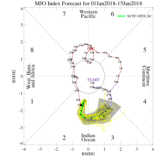
The timing of its formation coincides with the expected strengthening of MJO which is now over the Maritime Continent.

Image
[img]
Image
Image

Looks like a wet weather setup for the WPAC and SE Asia continues after Neoguri...
0 likes   
Personal Forecast Disclaimer:
The posts in this forum are NOT official forecast and should not be used as such. They are just the opinion of the poster and may or may not be backed by sound meteorological data. They are NOT endorsed by any professional institution or storm2k.org. For official information, please refer to the NHC and NWS products.

User avatar
euro6208
Category 5
Category 5
Posts: 18547
Joined: Mon Mar 08, 2004 7:50 pm
Location: Guam

Re: WPAC: INVEST 92W

#22 Postby euro6208 » Wed Jul 09, 2014 3:18 am

JTWC upped the chance to LOW!

AN AREA OF CONVECTION HAS PERSISTED NEAR 7.3N 154.4E,
APPROXIMATELY 150 NM EAST OF CHUUK. ANIMATED MULTISPECTRAL SATELLITE
IMAGERY DEPICTS A BROAD AND ILL-DEFINED LOW-LEVEL CIRCULATION CENTER
WITH FLARING AND DISORGANIZED CONVECTION. A 082328Z ASCAT PASS SHOWS
A HIGHLY DISORGANIZED AND ELONGATED CIRCULATION WITH 10 TO 15 KNOT
WINDS. SEA SURFACE TEMPERATURES IN THE REGION ARE CONDUCIVE FOR
DEVELOPMENT. UPPER-LEVEL ANALYSIS REVEALS A FAVORABLE ENVIRONMENT AS
HIGHLY DIFFLUENT OUTFLOW THAT IS BEING ENHANCED BY A TUTT CELL
LOCATED NORTHEAST OF THE SYSTEM. MAXIMUM SUSTAINED SURFACE WINDS ARE
ESTIMATED AT 10 TO 15 KNOTS. MINIMUM SEA LEVEL PRESSURE IS ESTIMATED
TO BE NEAR 1010 MB. THE POTENTIAL FOR THE DEVELOPMENT OF A
SIGNIFICANT TROPICAL CYCLONE WITHIN THE NEXT 24 HOURS IS LOW.
0 likes   
Remember, all of my post aren't official. For official warnings and discussions, Please refer to your local NWS products...

NWS for the Western Pacific

https://www.weather.gov/gum/

User avatar
cycloneye
Admin
Admin
Posts: 139041
Age: 67
Joined: Thu Oct 10, 2002 10:54 am
Location: San Juan, Puerto Rico

Re: WPAC: INVEST 92W

#23 Postby cycloneye » Wed Jul 09, 2014 4:55 am

NWS GUAM says there is uncertainty about this in terms of intensity and track as it moves thru the Marianas longitude.

LIGHT WINDS AND ISOLATED SHOWERS ARE ALL THAT IS EXPECTED THE
NEXT FEW DAYS. THE BIG DEBATE IS WHAT WILL HAPPEN TO A
CIRCULATION NOW LOCATED BETWEEN CHUUK AND POHNPEI. MOST MODELS DO
DEVELOP IT. THE GFS MAKES IT THE STRONGEST WHILE THE OTHER MODELS
KEEP IT WEAK.

GFS40 AND GFS ENSEMBLE PASS THE CIRCULATION NEAR ROTA ON SUNDAY
AT 6Z. ECMWF PASSES IT SOUTH OF GUAM SUNDAY NIGHT. NAVGEM IS
SIMILAR TO THE GFS AND GFS ENSEMBLE ONLY IT IS WEAKER. THE GFS
MODELS BOTH SHOWED IT PASSING NORTH OF SAIPAN YESTERDAY. SO THE
TREND OF THE GFS SEEMS TO BE TRACKING THE SYSTEM FURTHER SOUTH.
WILL THE GFS MODELS AND ECMWF EVENTUALLY AGREE ON THE CIRCULATION
PASSING CLOSE TO BUT SOUTH OF GUAM?

NO MATTER WHAT IT EVENTUALLY BECOMES OR THE TRACK IT TAKES...
MOST LIKELY IT SHOULD PRODUCE SOME RAIN. THE MOST LIKELY TIME IS
SUNDAY NIGHT THROUGH MONDAY NIGHT SO ADDED SCATTERED SHOWERS TO
THE FORECAST THEN.

BECAUSE ONE MODEL SHOW THE CIRCULATION PASSING NORTH OF GUAM AND
ONE SOUTH WIND FORECAST IS UNCERTAIN. WITH THE MODELS SO MIXED ON
WINDS AND WIND DIRECTIONS CAN ONLY CAN VOUCH FOR WIND FORECAST
THROUGH SATURDAY AFTER THAT UNCERTAINTY BECOMES GREATER.
0 likes   
Visit the Caribbean-Central America Weather Thread where you can find at first post web cams,radars
and observations from Caribbean basin members Click Here

User avatar
xtyphooncyclonex
Category 5
Category 5
Posts: 3688
Age: 22
Joined: Sat Dec 08, 2012 9:07 am
Location: Cebu City
Contact:

#24 Postby xtyphooncyclonex » Wed Jul 09, 2014 5:05 am

What does the CMC show in their latest run? It is more or less the best performer this year, in terms of forecasting formation of a typhoon, and did close calls to many storms.
0 likes   
REMINDER: My opinions that I, or any other NON Pro-Met in this forum, are unofficial. Please do not take my opinions as an official forecast and warning. I am NOT a meteorologist. Following my forecasts blindly may lead to false alarm, danger and risk if official forecasts from agencies are ignored.
stormcruisin

Re:

#25 Postby stormcruisin » Wed Jul 09, 2014 6:29 am

xtyphooncyclonex wrote:What does the CMC show in their latest run? It is more or less the best performer this year, in terms of forecasting formation of a typhoon, and did close calls to many storms.


Image


Image
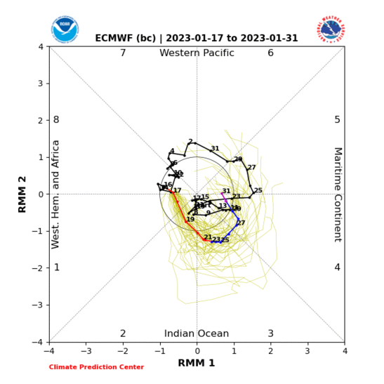
EC along the same lines as global model no interest in TY atm.
0 likes   

User avatar
cycloneye
Admin
Admin
Posts: 139041
Age: 67
Joined: Thu Oct 10, 2002 10:54 am
Location: San Juan, Puerto Rico

Re: WPAC: INVEST 92W

#26 Postby cycloneye » Wed Jul 09, 2014 8:31 am

12z Best Track:

92W INVEST 140709 1200 8.3N 154.1E WPAC 15 1010
0 likes   
Visit the Caribbean-Central America Weather Thread where you can find at first post web cams,radars
and observations from Caribbean basin members Click Here

User avatar
euro6208
Category 5
Category 5
Posts: 18547
Joined: Mon Mar 08, 2004 7:50 pm
Location: Guam

Re: WPAC: INVEST 92W

#27 Postby euro6208 » Wed Jul 09, 2014 9:03 am

Image

Superb outflow linked to a TUTT cell and quite small and in a very very favorable environment...

I see JTWC upgrading potential to Medium very soon...
0 likes   
Remember, all of my post aren't official. For official warnings and discussions, Please refer to your local NWS products...

NWS for the Western Pacific

https://www.weather.gov/gum/

User avatar
cycloneye
Admin
Admin
Posts: 139041
Age: 67
Joined: Thu Oct 10, 2002 10:54 am
Location: San Juan, Puerto Rico

Re: WPAC: INVEST 92W

#28 Postby cycloneye » Wed Jul 09, 2014 10:11 am

It looks like it may be Taiwans turn to have a hit by a strong Typhoon if the models verify.

Image
0 likes   
Visit the Caribbean-Central America Weather Thread where you can find at first post web cams,radars
and observations from Caribbean basin members Click Here

User avatar
cycloneye
Admin
Admin
Posts: 139041
Age: 67
Joined: Thu Oct 10, 2002 10:54 am
Location: San Juan, Puerto Rico

Re: WPAC: INVEST 92W

#29 Postby cycloneye » Wed Jul 09, 2014 11:42 am

12z GFS shows a monster threatening Taiwan but a little bit north of past runs.Yes,that is 910 mbs. :eek:

Image
0 likes   
Visit the Caribbean-Central America Weather Thread where you can find at first post web cams,radars
and observations from Caribbean basin members Click Here

User avatar
cycloneye
Admin
Admin
Posts: 139041
Age: 67
Joined: Thu Oct 10, 2002 10:54 am
Location: San Juan, Puerto Rico

Re: WPAC: INVEST 92W

#30 Postby cycloneye » Wed Jul 09, 2014 1:11 pm

It looks like is organizing at a steady pace.

Image
0 likes   
Visit the Caribbean-Central America Weather Thread where you can find at first post web cams,radars
and observations from Caribbean basin members Click Here

User avatar
cycloneye
Admin
Admin
Posts: 139041
Age: 67
Joined: Thu Oct 10, 2002 10:54 am
Location: San Juan, Puerto Rico

Re: WPAC: INVEST 92W

#31 Postby cycloneye » Wed Jul 09, 2014 1:51 pm

18z Best Track:

92W INVEST 140709 1800 8.3N 152.7E WPAC 15 1010
0 likes   
Visit the Caribbean-Central America Weather Thread where you can find at first post web cams,radars
and observations from Caribbean basin members Click Here

User avatar
cycloneye
Admin
Admin
Posts: 139041
Age: 67
Joined: Thu Oct 10, 2002 10:54 am
Location: San Juan, Puerto Rico

Re: WPAC: INVEST 92W

#32 Postby cycloneye » Wed Jul 09, 2014 2:07 pm

Ummm,is interesting that ECMWF doesn't develop this.
0 likes   
Visit the Caribbean-Central America Weather Thread where you can find at first post web cams,radars
and observations from Caribbean basin members Click Here

User avatar
Hurricane_Luis
Category 2
Category 2
Posts: 723
Age: 25
Joined: Sat Jun 23, 2012 3:14 pm
Location: Tiptree, Essex, United Kingdom
Contact:

Re: WPAC: INVEST 92W

#33 Postby Hurricane_Luis » Wed Jul 09, 2014 2:52 pm

cycloneye wrote:Ummm,is interesting that ECMWF doesn't develop this.


Nothing new there then. Although the latest GFS run does.
0 likes   

User avatar
cycloneye
Admin
Admin
Posts: 139041
Age: 67
Joined: Thu Oct 10, 2002 10:54 am
Location: San Juan, Puerto Rico

Re: WPAC: INVEST 92W

#34 Postby cycloneye » Wed Jul 09, 2014 4:11 pm

THis is the latest Guam NWS discussion about 92W.

NAVGEM STILL DOES NOT HAVE A HANDLE ON 92W...SO GRID UPDATES WERE
BASED ON THE LATEST RUNS OF THE GFS AND ECMWF. BOTH THE ECMWF AND
GFS ARE TRENDING TOWARD THE SOUTH WITH THE FORECAST TRACK OF 92W.
AM BUYING INTO THIS TREND...AS UPPER-LEVEL ENVIRONMENT TO THE
NORTH OF 92W LOOKS QUITE HOSTILE WITH EXTENSIVE MID TO UPPER-
LEVEL TROUGHING IN PLACE TO THE NORTH OF 92W. WATER VAPOR LOOP
ALSO SUGGESTS MID-LEVEL RIDGING IS BEGINNING TO BUILD OVER
92W...WHICH SHOULD HELP THIS RELATIVELY SMALL SYSTEM STEER CLOSER
TO WEST VERSUS NORTHWEST. BASED UPON ALL OF THIS...REDID WINDS
DAYS 2 THRU 8. GRID UPDATES TRACK 92W ON A FASTER TRACK SOUTH OF
GUAM SATURDAY NIGHT AND SUNDAY. ADDED SCATTERED SHOWERS TO THE
FORECAST GRIDS BEGINNING ON SATURDAY NIGHT ACCORDINGLY. KEPT
SCATTERED SHOWERS IN THE FORECAST FOR MONDAY AND MONDAY NIGHT AS
DEEP MOISTURE REMAINS IN PLACE FOLLOWING THE PASSAGE OF 92W. THE
GFS AND ECMWF BOTH SUGGEST THE TROPICAL DISTURBANCE NORTHEAST OF
POHNPEI COULD EVENTUALLY FOLLOW A TRACK SIMILAR TO THAT OF 92W AND
AFFECT THE FORECAST ZONES AROUND THE MIDDLE OF NEXT WEEK. STRONGER
RIDGING IN PLACE TO THE NORTH OF THESE SYSTEMS WOULD DELAY ANY
NORTHWARD MOVEMENT OF THE MONSOON TROUGH...SO HAVE DELAYED PASSAGE
OF THE TROUGH TO THE NORTH OF THE FORECAST ZONES UNTIL DAY 8.
0 likes   
Visit the Caribbean-Central America Weather Thread where you can find at first post web cams,radars
and observations from Caribbean basin members Click Here

User avatar
xtyphooncyclonex
Category 5
Category 5
Posts: 3688
Age: 22
Joined: Sat Dec 08, 2012 9:07 am
Location: Cebu City
Contact:

#35 Postby xtyphooncyclonex » Wed Jul 09, 2014 5:05 pm

I guess this may pan out due to the high consistency bstween GFS & CMC with this potential typhoon.
0 likes   
REMINDER: My opinions that I, or any other NON Pro-Met in this forum, are unofficial. Please do not take my opinions as an official forecast and warning. I am NOT a meteorologist. Following my forecasts blindly may lead to false alarm, danger and risk if official forecasts from agencies are ignored.
User avatar
StormingB81
S2K Supporter
S2K Supporter
Posts: 5676
Age: 42
Joined: Thu Aug 27, 2009 1:45 am
Location: Rockledge, Florida

#36 Postby StormingB81 » Wed Jul 09, 2014 5:17 pm

Looking at the Forecast for Okinawa....With all that flooding there is a lot of rain foretasted for the next few days..if it does that and this comes anywhere close it could mean huge trouble for Okinawa..not saying thats where it is going however just saying if it ends up happening and not even this one any one anytime soon
0 likes   

User avatar
cycloneye
Admin
Admin
Posts: 139041
Age: 67
Joined: Thu Oct 10, 2002 10:54 am
Location: San Juan, Puerto Rico

Re: WPAC: INVEST 92W

#37 Postby cycloneye » Wed Jul 09, 2014 7:31 pm

00z Best Track:

92W INVEST 140710 0000 9.1N 151.8E WPAC 20 1007
0 likes   
Visit the Caribbean-Central America Weather Thread where you can find at first post web cams,radars
and observations from Caribbean basin members Click Here

stormcruisin

#38 Postby stormcruisin » Wed Jul 09, 2014 7:51 pm

Image


Image

Maybe the EC is sickly wrong with this invest or its the other disturbance mentioned in the discussion that follows that develops into the system modeled to bomb will be interesting to see what models are on the mark. GFS and cmc are always bullish most of the time.
0 likes   

User avatar
cycloneye
Admin
Admin
Posts: 139041
Age: 67
Joined: Thu Oct 10, 2002 10:54 am
Location: San Juan, Puerto Rico

Re: WPAC: INVEST 92W

#39 Postby cycloneye » Wed Jul 09, 2014 8:34 pm

:uarrow: Is this one. JTWC upgraded to Medium.

THE AREA OF CONVECTION PREVIOUSLY LOCATED NEAR 7.3N
154.4E, IS NOW LOCATED NEAR 9.1N 151.8E, APPROXIMATELY 103 NM NORTH
OF CHUUK, FSM. ANIMATED MULTISPECTRAL SATELLITE IMAGERY SHOWS A
COMPACT SYSTEM THAT HAS BEGUN TO CONSOLIDATE AS FORMATIVE BANDS
ARE WRAPPING TIGHTER INTO AN OBSCURED LOW-LEVEL CIRCULATION CENTER.
UPPER-LEVEL ANALYSIS INDICATES A FAVORABLE ENVIRONMENT WITH DUAL
OUTFLOW - ONE ENHANCED BY A TUTT CELL TO THE NORTHEAST AND A
WESTWARD OUTFLOW ENHANCED BY THE STRONG EASTERLY WINDS ALONG THE
SOUTHERN PERIPHERY OF THE RIDGE TO THE NORTH. NUMERIC WEATHER
PREDICTION MODELS DEVELOP THIS AREA IN VARYING DEGREES WITH THE MOST
AGGRESSIVE BEING GFS. MAXIMUM SUSTAINED SURFACE WINDS ARE ESTIMATED
AT 15 TO 20 KNOTS. MINIMUM SEA LEVEL PRESSURE IS ESTIMATED TO BE
NEAR 1007 MB. DUE TO THE IMPROVING ENVIRONMENTAL CONDITIONS, THE
POTENTIAL FOR THE DEVELOPMENT OF A SIGNIFICANT TROPICAL CYCLONE
WITHIN THE NEXT 24 HOURS IS UPGRADED TO MEDIUM.
0 likes   
Visit the Caribbean-Central America Weather Thread where you can find at first post web cams,radars
and observations from Caribbean basin members Click Here

stormcruisin

#40 Postby stormcruisin » Wed Jul 09, 2014 8:39 pm

Image
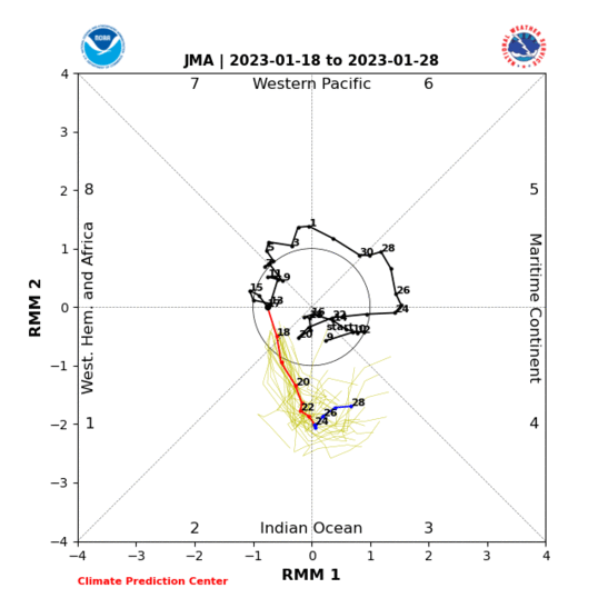
JMA model.
0 likes   


Return to “2014”

Who is online

Users browsing this forum: No registered users and 49 guests