The hurricane belt is ripe for 2014. It had that 'feel' around here the last two days. I should have posted.
This has a pretty good center from its appearance but we've seen more than one of these get shredded too.
ATL: TWO - Remnants - Discussion
Moderator: S2k Moderators
Re: ATL: INVEST 92L - Discussion
0 likes
-
cycloneye

- Admin

- Posts: 139028
- Age: 67
- Joined: Thu Oct 10, 2002 10:54 am
- Location: San Juan, Puerto Rico
Re: ATL: INVEST 92L - Discussion
Let's see if this bouy (41041) located at 14.6N-46.4W collects data as it moves south of there.
Bouy 41041
Bouy 41041
0 likes
Visit the Caribbean-Central America Weather Thread where you can find at first post web cams,radars
and observations from Caribbean basin members Click Here
and observations from Caribbean basin members Click Here
Re: ATL: INVEST 92L - Discussion
Warm tops should be an indication of lack of staying power.
0 likes
-
TheStormExpert

- Category 5

- Posts: 8487
- Age: 30
- Joined: Wed Feb 16, 2011 5:38 pm
- Location: Palm Beach Gardens, FL
Re:
HurricaneBrain wrote:IS THAT AN EYE?On a serious note, 92L looks close to depression status and could dodge the unfavorable conditions in its path. The intensity forecasts surprisingly suggest a strengthening tropical storm in the next couple of days.
Intensity forecast have pretty much sucked IMO over the past few years (especially last year) for storms that have formed in MDR. In my honest opinion 92L will be luck to even become a weak TS at best.
0 likes
The following post is NOT an official forecast and should not be used as such. It is just the opinion of the poster and may or may not be backed by sound meteorological data. It is NOT endorsed by storm2k.org.
-
HurricaneTracker2031
- Tropical Storm

- Posts: 248
- Age: 24
- Joined: Fri Jul 19, 2013 7:20 pm
- Location: Pembroke Pines, FL, USA
- Contact:
Re: ATL: INVEST 92L - Discussion
92L is looking pretty good and survived through the night to be tagged. As shown on satellite imagery, there is now a well defined center and convection is filling the center and its beginning to wrap around all that convection. Therefore, it is intensifying.....

Synopsis on 91L and other areas in other basins: http://goo.gl/WYthWi
Personal Forecast Disclaimer:
The posts in this forum are NOT official forecast and should not be used as such. They are just the opinion of the poster and may or may not be backed by sound meteorological data. They are NOT endorsed by any professional institution or storm2k.org. For official information, please refer to the NHC and NWS products.
0 likes
SHORT VERSION OF DISCLAIMER: THIS SITE LINK BELOW IS NOT AN OFFICIAL FORECASTING OFFICE AND SHOULD NOT BE USED TO MAKE ANY EMERGENCY DECISIONS....
http://www.macstropicalweather.weebly.com
http://www.macstropicalweather.weebly.com
-
Miami Storm Tracker

- Category 3

- Posts: 893
- Age: 66
- Joined: Sun Jun 13, 2010 10:12 pm
- Location: Key Largo, Fla.
- Contact:
Re: ATL: INVEST 92L - Discussion
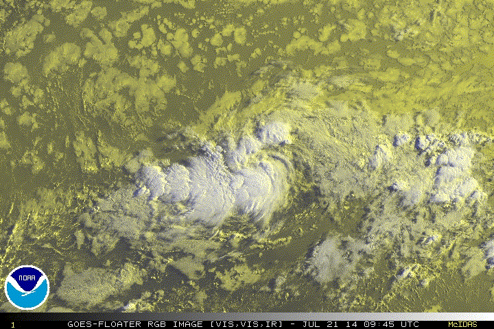
Nice shot of 92L there,
I was just looking at the floater for 92l on both visible and IR this invest is looking strong at the moment. Seems to have a good circulation and even some possible inflow.
I was just looking at the floater for 92l on both visible and IR this invest is looking strong at the moment. Seems to have a good circulation and even some possible inflow.
0 likes
-
JonathanBelles
- Professional-Met

- Posts: 11430
- Age: 33
- Joined: Sat Dec 24, 2005 9:00 pm
- Location: School: Florida State University (Tallahassee, FL) Home: St. Petersburg, Florida
- Contact:
Re: ATL: INVEST 92L - Discussion
This seems to be a case where visible imagery is giving the appearance of a TC while the data suggests otherwise. The ASCAT data from this morning shows an area of westerly winds well removed from the center, but stronger winds nearing TS Strength...both features mentioned in slight by the NHC. I think this feature may need a night or two before true formation can take place. This small system may get taken over by the dry air quickly. I'm still not sure if this is the suicide wave that I thought it was originally or not.
0 likes
-
Blown Away

- S2K Supporter

- Posts: 9861
- Joined: Wed May 26, 2004 6:17 am
Re: ATL: INVEST 92L - Discussion
My Forecast For 92L:
24 hours: Poof.
48 hours: We track a naked LLC.
72 hours: Bones makes an appearance.
96 hours: 92L deactivated.

24 hours: Poof.
48 hours: We track a naked LLC.
72 hours: Bones makes an appearance.
96 hours: 92L deactivated.
0 likes
Hurricane Eye Experience: David 79, Irene 99, Frances 04, Jeanne 04, Wilma 05...
Hurricane Brush Experience: Andrew 92, Erin 95, Floyd 99, Matthew 16, Irma 17, Ian 22, Nicole 22…
Hurricane Brush Experience: Andrew 92, Erin 95, Floyd 99, Matthew 16, Irma 17, Ian 22, Nicole 22…
-
hurricaneCW
- Category 5
- Posts: 1773
- Joined: Wed Mar 03, 2010 6:20 am
- Location: Toms River, NJ
Re: ATL: INVEST 92L - Discussion
I've seen much worse looking systems get classified than 92L.
0 likes
-
tolakram
- Admin
- Posts: 19165
- Age: 60
- Joined: Sun Aug 27, 2006 8:23 pm
- Location: Florence, KY (name is Mark)
Re: ATL: INVEST 92L - Discussion
0 likes
M a r k
- - - - -
Join us in chat: Storm2K Chatroom Invite. Android and IOS apps also available.
The posts in this forum are NOT official forecasts and should not be used as such. Posts are NOT endorsed by any professional institution or STORM2K.org. For official information and forecasts, please refer to NHC and NWS products.
-
tolakram
- Admin
- Posts: 19165
- Age: 60
- Joined: Sun Aug 27, 2006 8:23 pm
- Location: Florence, KY (name is Mark)
Re: ATL: INVEST 92L - Discussion
Saved RGB loop appears to show an LLC ... maybe.
link: http://imageshack.com/a/img905/4504/d3d96a.gif
link: http://imageshack.com/a/img905/4504/d3d96a.gif
0 likes
M a r k
- - - - -
Join us in chat: Storm2K Chatroom Invite. Android and IOS apps also available.
The posts in this forum are NOT official forecasts and should not be used as such. Posts are NOT endorsed by any professional institution or STORM2K.org. For official information and forecasts, please refer to NHC and NWS products.
- - - - -
Join us in chat: Storm2K Chatroom Invite. Android and IOS apps also available.
The posts in this forum are NOT official forecasts and should not be used as such. Posts are NOT endorsed by any professional institution or STORM2K.org. For official information and forecasts, please refer to NHC and NWS products.

Re: ATL: INVEST 92L - Discussion
Looks like it could be upgraded later today--development chances in six hours went from 20% to 70%.
0 likes
The above post is not official and should not be used as such. It is the opinion of the poster and may or may not be backed by sound meteorological data. It is not endorsed by any professional institution or storm2k.org. For official information, please refer to the NHC and NWS products.
-
HurricaneTracker2031
- Tropical Storm
- Posts: 248
- Age: 24
- Joined: Fri Jul 19, 2013 7:20 pm
- Location: Pembroke Pines, FL, USA
- Contact:
Re: ATL: INVEST 92L - Discussion
CODE RED
70/70
Tropical Weather Outlook Text
TROPICAL WEATHER OUTLOOK
NWS NATIONAL HURRICANE CENTER MIAMI FL
200 PM EDT MON JUL 21 2014
For the North Atlantic...Caribbean Sea and the Gulf of Mexico:
1. Shower activity associated with a small area of low pressure located
about 1250 miles east of the Lesser Antilles has continued to
increase and show signs of organization during the past few hours.
Satellite data indicate that the circulation has become better
defined and the system is producing a small area of winds near
tropical storm force. Only a small increase in organization of the
shower activity would result in the formation of a tropical
depression as the system moves westward to west-northwestward at 15
to 20 mph during the next day or two. After that time, however,
environmental conditions are expected to become less conducive for
development or strengthening. Interests in the Lesser Antilles
should monitor the progress of this system.
* Formation chance through 48 hours...high...70 percent.
* Formation chance through 5 days...high...70 percent.
Forecaster Brennan
0 likes
SHORT VERSION OF DISCLAIMER: THIS SITE LINK BELOW IS NOT AN OFFICIAL FORECASTING OFFICE AND SHOULD NOT BE USED TO MAKE ANY EMERGENCY DECISIONS....
http://www.macstropicalweather.weebly.com
http://www.macstropicalweather.weebly.com


-
HurricaneBrain

- S2K Supporter
- Posts: 430
- Joined: Thu Jun 30, 2011 2:07 pm
- Location: Beaumont, TX
Re: ATL: INVEST 92L - Discussion
underthwx wrote:This gonna be a GOM or an Atlantic storm?
Way too early to determine that. The models somewhat show a GOM path in the long term, but it must first make it through dry air and high wind shear. Even then, the forecast models will constantly be changing. There should be more of a consensus in 72 hours.
0 likes
-
wxman57

- Moderator-Pro Met

- Posts: 22480
- Age: 66
- Joined: Sat Jun 21, 2003 8:06 pm
- Location: Houston, TX (southwest)
Re: ATL: INVEST 92L - Discussion
Blown Away wrote:My Forecast For 92L:
24 hours: Poof.
48 hours: We track a naked LLC.
72 hours: Bones makes an appearance.
96 hours: 92L deactivated.
Bones said that the best chance of development is today through the next 24-36 hours. Beyond then it will encounter increasingly hostile conditions.
0 likes
Re: ATL: INVEST 92L - Discussion
Most know how conservative I am about developing systems (Arthur, Sandy, etc.) but am impressed by this system - I wouldn't have known but happened to receive a tweet from the NHC a few minutes ago, and the tweeted photo took me by surprise - an Atlantic system like that takes me back to my weather days of the 1980's...
We'll see what happens, but I tend to agree with Sanibel : ( - our own rainy season here in South Florida has been incredible this year (we had 7 1/2 feet of rain last year and might exceed that amount this year - my roof is leaking) and don't know how that'll affect things, though another deep trough (summer-polar vortex) is shown on the GFS the next 5-10 days, so we'll see...
Frank
Last edited by Frank2 on Mon Jul 21, 2014 12:57 pm, edited 1 time in total.
0 likes
-
Miami Storm Tracker
- Category 3
- Posts: 893
- Age: 66
- Joined: Sun Jun 13, 2010 10:12 pm
- Location: Key Largo, Fla.
- Contact:
Who is online
Users browsing this forum: No registered users and 27 guests