ATL: BERTHA - Post-Tropical - Discussion
Moderator: S2k Moderators

Re: ATL: BERTHA - Tropical Storm - Discussion
Weakest looking hurricane ever...if this was in the pacific, it would only be a 45-50 knot system based on dvorak which is only 3.0///
0 likes
Remember, all of my post aren't official. For official warnings and discussions, Please refer to your local NWS products...
NWS for the Western Pacific
https://www.weather.gov/gum/
NWS for the Western Pacific
https://www.weather.gov/gum/
-
WilmingtonSandbar
- S2K Supporter

- Posts: 503
- Joined: Sun Aug 29, 2010 12:11 pm
- Location: Southport, NC
Re: ATL: BERTHA - Tropical Storm - Discussion
euro6208 wrote:Weakest looking hurricane ever...if this was in the pacific, it would only be a 45-50 knot system based on dvorak which is only 3.0///
Might be because it is not a hurricane. It is still a TS.
0 likes
Diana X2 (look it up), Bertha, Fran, Bonnie, Floyd, Dennis, Charley, Ophelia, Ernesto, Irene, Matthew, And Florence
Re: ATL: BERTHA - Tropical Storm - Discussion
WilmingtonSandbar wrote:euro6208 wrote:Weakest looking hurricane ever...if this was in the pacific, it would only be a 45-50 knot system based on dvorak which is only 3.0///
Might be because it is not a hurricane. It is still a TS.
I meant near hurricane
0 likes
Remember, all of my post aren't official. For official warnings and discussions, Please refer to your local NWS products...
NWS for the Western Pacific
https://www.weather.gov/gum/
NWS for the Western Pacific
https://www.weather.gov/gum/
-
xtyphooncyclonex

- Category 5

- Posts: 3688
- Age: 22
- Joined: Sat Dec 08, 2012 9:07 am
- Location: Cebu City
- Contact:
Re: ATL: BERTHA - Tropical Storm - Discussion
euro6208 wrote:Weakest looking hurricane ever...if this was in the pacific, it would only be a 45-50 knot system based on dvorak which is only 3.0///
Bertha is not yet a hurricane, but it is a high-end tropical storm strength. Don't be too reliant on Dvorak and satellite imagery, and the data is showing 55 kts and is the opposite of what happened to Arthur wherein satellite and Dvorak estimates were showing a cat 3 but ended up having cat 1-2 winds.
Anyway, Bertha has a more improved structure now. However, the convection is quite weak right now, it needs some time.
0 likes
REMINDER: My opinions that I, or any other NON Pro-Met in this forum, are unofficial. Please do not take my opinions as an official forecast and warning. I am NOT a meteorologist. Following my forecasts blindly may lead to false alarm, danger and risk if official forecasts from agencies are ignored.

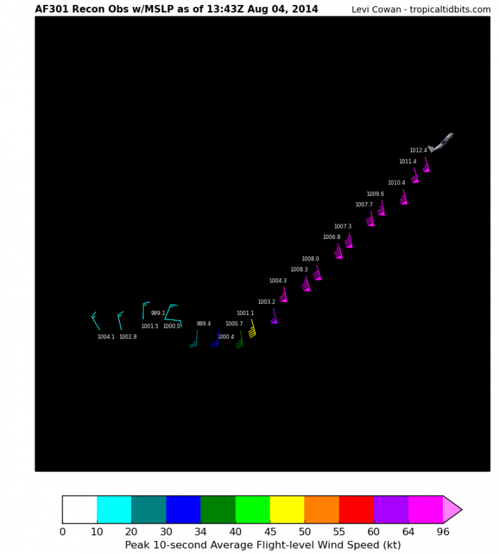
86 knots flight level winds!!!
133900 2723N 07324W 8430 01518 0043 +176 +176 169069 076 069 014 00
133930 2724N 07322W 8434 01538 0083 +167 +167 163080 086 069 026 00
134000 2725N 07321W 8423 01545 0080 +158 +158 162079 082 072 023 00
134030 2727N 07319W 8427 01547 0068 +167 +157 164084 085 069 012 00
134100 2728N 07318W 8429 01547 0073 +164 +161 167083 086 068 009 00
134130 2730N 07316W 8436 01546 0077 +170 +156 168079 084 065 007 03
0 likes
-
Equilibrium
The low is looking much better now its starting to look well wrapped and getting tighter.
The posts in this forum are NOT official forecast and should not be used as such. They are just the opinion of the poster and may or may not be backed by sound meteorological data. They are NOT endorsed by any professional institution or storm2k.org. For official information, please refer to the NHC and NWS products.
The posts in this forum are NOT official forecast and should not be used as such. They are just the opinion of the poster and may or may not be backed by sound meteorological data. They are NOT endorsed by any professional institution or storm2k.org. For official information, please refer to the NHC and NWS products.
0 likes
-
SouthDadeFish

- Professional-Met

- Posts: 2835
- Joined: Thu Sep 23, 2010 2:54 pm
- Location: Miami, FL
- Contact:
Dropsonde just measured 83 knots at the surface. Somehow, some way, this is a hurricane folks.
Edited to include drop info:
1006mb (29.71 inHg) Sea Level (Surface) 24.4°C (75.9°F) 23.3°C (73.9°F) 140° (from the SE) 83 knots (96 mph)
Edited to include drop info:
1006mb (29.71 inHg) Sea Level (Surface) 24.4°C (75.9°F) 23.3°C (73.9°F) 140° (from the SE) 83 knots (96 mph)
Last edited by SouthDadeFish on Mon Aug 04, 2014 9:05 am, edited 1 time in total.
0 likes

Re:
CrazyC83 wrote:How high to go? That dropsonde is 86 kt at the surface or aloft? Otherwise the data supports 70 kt.
Significant Wind Levels...
Level Wind Direction Wind Speed
1006mb (Surface) 140° (from the SE) 83 knots (96 mph)
0 likes

-
weathernerdguy

- Tropical Storm

- Posts: 188
- Age: 22
- Joined: Wed Jul 10, 2013 8:44 pm
But then again, look at the surrounding pressures, and then look at the pressure, if it was a normal year, the pressure would be around 986-984 millibars.
0 likes
The posts in this forum are NOT official forecast and should not be used as such. They are just the opinion of the poster and may or may not be backed by sound meteorological data. They are NOT endorsed by any professional institution or storm2k.org. For official information, please refer to the NHC and NWS products

...BERTHA BECOMES THE SECOND HURRICANE OF THE 2014 ATLANTIC
SEASON...
SUMMARY OF 1100 AM EDT...1500 UTC...INFORMATION
-----------------------------------------------
LOCATION...27.6N 73.6W
ABOUT 230 MI...370 KM ENE OF GREAT ABACO ISLAND
MAXIMUM SUSTAINED WINDS...80 MPH...130 KM/H
PRESENT MOVEMENT...N OR 360 DEGREES AT 17 MPH...28 KM/H
MINIMUM CENTRAL PRESSURE...998 MB...29.47 INCHES
0 likes
-
tolakram
- Admin

- Posts: 19165
- Age: 60
- Joined: Sun Aug 27, 2006 8:23 pm
- Location: Florence, KY (name is Mark)
Re: ATL: BERTHA - Hurricane - Discussion
0 likes
M a r k
- - - - -
Join us in chat: Storm2K Chatroom Invite. Android and IOS apps also available.
The posts in this forum are NOT official forecasts and should not be used as such. Posts are NOT endorsed by any professional institution or STORM2K.org. For official information and forecasts, please refer to NHC and NWS products.
-
weathernerdguy
- Tropical Storm
- Posts: 188
- Age: 22
- Joined: Wed Jul 10, 2013 8:44 pm
The world without recon.
0 likes
The posts in this forum are NOT official forecast and should not be used as such. They are just the opinion of the poster and may or may not be backed by sound meteorological data. They are NOT endorsed by any professional institution or storm2k.org. For official information, please refer to the NHC and NWS products
Who is online
Users browsing this forum: No registered users and 36 guests