Blown Away wrote::uarrow: I wonder if such a dramatic right hook is an indication of getting trapped under high pressure and/or loop?
Exactly! First storm that comes to mind is Jeanne(2004).
Moderator: S2k Moderators


Blown Away wrote::uarrow: I wonder if such a dramatic right hook is an indication of getting trapped under high pressure and/or loop?


SeGaBob wrote:So do any computer models show the no recurve (or at least delayed) scenario anymore?


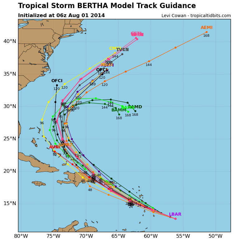
gatorcane wrote:From what I am seeing from the computer models, Bertha is able to round the western periphery of the Bermuda High ridge before that ridge can build westward over the SW Atlantic. Once she gets ejected off to the NE, that ridge does build in though. So because of her fast forward speed, it looks like she is going to find the escape route. If she were a couple of days slower clearing the islands, she probably would get blocked in the Bahamas.
The models are actually in good agreement on a recurve. There are several GFS ensemble members that bring her a bit more west into the Southern Bahamas without a recurve but those are likely keeping her an open wave and seem like outliers right now.
The posts in this forum are NOT official forecast and should not be used as such. They are just the opinion of the poster and may or may not be backed by sound meteorological data. They are NOT endorsed by any professional institution or storm2k.org. For official information, please refer to the NHC and NWS products.
Airboy wrote:gatorcane wrote:From what I am seeing from the computer models, Bertha is able to round the western periphery of the Bermuda High ridge before that ridge can build westward over the SW Atlantic. Once she gets ejected off to the NE, that ridge does build in though. So because of her fast forward speed, it looks like she is going to find the escape route. If she were a couple of days slower clearing the islands, she probably would get blocked in the Bahamas.
The models are actually in good agreement on a recurve. There are several GFS ensemble members that bring her a bit more west into the Southern Bahamas without a recurve but those are likely keeping her an open wave and seem like outliers right now.
The posts in this forum are NOT official forecast and should not be used as such. They are just the opinion of the poster and may or may not be backed by sound meteorological data. They are NOT endorsed by any professional institution or storm2k.org. For official information, please refer to the NHC and NWS products.
Could a stronger system mean a slower system that would allowed the ridge to build more before Bertha arrives and can move around it and force it moving more west or do the strength and size don't matter to the speed of the system?
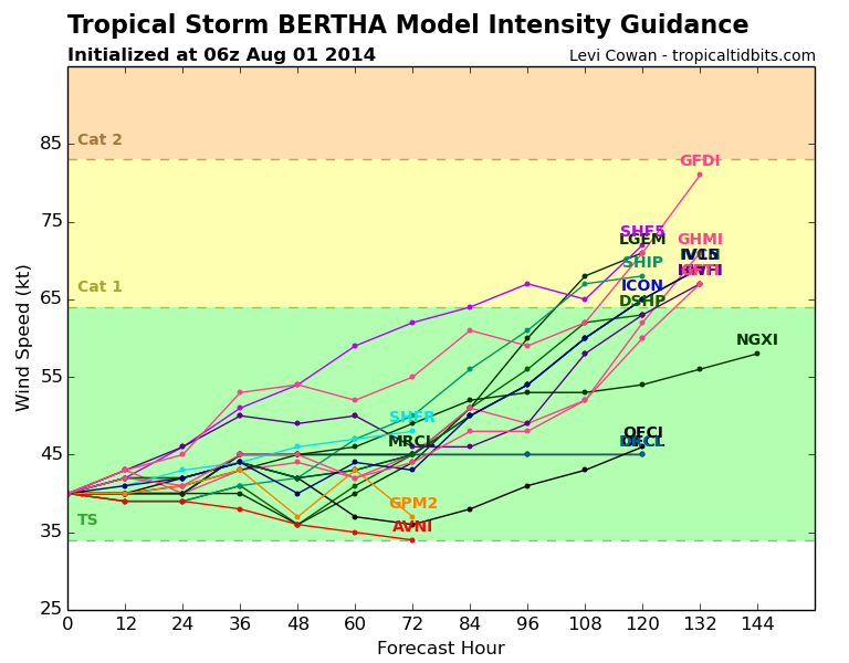
somethingfunny wrote:I can't take any of these intensity models seriously as long as Hispaniola is in the projected path.
I can't really take any of the track models post-Hispaniola too seriously either since a severely disrupted storm would probably just drift westward afterward and have to run a reboot cycle.


blp wrote:Saw this on another board the Nasa model has a possible visit with Florida. I don't know how reliable this is but it is interesting.
Users browsing this forum: No registered users and 100 guests