ATL: CRISTOBAL - Post-Tropical - Discussion

Moderator: S2k Moderators

Message
Author
WeatherEmperor
S2K Supporter
S2K Supporter
Posts: 4806
Age: 40
Joined: Thu Sep 04, 2003 2:54 pm
Location: South Florida

Re: ATL: INVEST 96L - Discussion

#61 Postby WeatherEmperor » Tue Aug 19, 2014 8:51 pm

CrazyC83 wrote:Am I the only one that gets an Ernesto (2006) vibe on this one?


No you are not alone on this. There is plenty of time to see what happens but because of the strange geography of the islands, the smallest deviation in track can have huge implications. Lets find out what happens...

Sent from my HTC EVO 4G LTE
0 likes   

stormlover2013
Category 5
Category 5
Posts: 2312
Joined: Thu Aug 22, 2013 12:06 pm
Location: Lumberton, Texas

ATL: INVEST 96L - Models

#62 Postby stormlover2013 » Tue Aug 19, 2014 9:03 pm

I'll say this and just my opinion this isn't a east coast storm

Personal Forecast Disclaimer:
The posts in this forum are NOT official forecast and should not be used as such. They are just the opinion of the poster and may or may not be backed by sound meteorological data. They are NOT endorsed by any professional institution or storm2k.org. For official information, please refer to the NHC and NWS products.
0 likes   

User avatar
TheStormExpert
Category 5
Category 5
Posts: 8487
Age: 30
Joined: Wed Feb 16, 2011 5:38 pm
Location: Palm Beach Gardens, FL

Re: ATL: INVEST 96L - Discussion

#63 Postby TheStormExpert » Tue Aug 19, 2014 9:04 pm

WeatherEmperor wrote:
CrazyC83 wrote:Am I the only one that gets an Ernesto (2006) vibe on this one?


No you are not alone on this. There is plenty of time to see what happens but because of the strange geography of the islands, the smallest deviation in track can have huge implications. Lets find out what happens...

Sent from my HTC EVO 4G LTE

The good thing about Ernesto's situation is that after skimming west of Hispanola and going over the spine of Cuba it never was able to get it's act together like forecasters were expecting in the Florida Straits, therefore it only hit Florida as a TD/TS.
0 likes   
The following post is NOT an official forecast and should not be used as such. It is just the opinion of the poster and may or may not be backed by sound meteorological data. It is NOT endorsed by storm2k.org.

User avatar
TheStormExpert
Category 5
Category 5
Posts: 8487
Age: 30
Joined: Wed Feb 16, 2011 5:38 pm
Location: Palm Beach Gardens, FL

Re: ATL: INVEST 96L - Models

#64 Postby TheStormExpert » Tue Aug 19, 2014 9:05 pm

stormlover2013 wrote:I'll say this and just my opinion this isn't a east coast storm

It's kind of way too early to say.
0 likes   
The following post is NOT an official forecast and should not be used as such. It is just the opinion of the poster and may or may not be backed by sound meteorological data. It is NOT endorsed by storm2k.org.

stormlover2013
Category 5
Category 5
Posts: 2312
Joined: Thu Aug 22, 2013 12:06 pm
Location: Lumberton, Texas

Re: ATL: INVEST 96L - Models

#65 Postby stormlover2013 » Tue Aug 19, 2014 9:07 pm

Not to early, this thing is going to stay weak until it rides through the carrib...95 percent it's not hitting east coast

Personal Forecast Disclaimer:
The posts in this forum are NOT official forecast and should not be used as such. They are just the opinion of the poster and may or may not be backed by sound meteorological data. They are NOT endorsed by any professional institution or storm2k.org. For official information, please refer to the NHC and NWS products.
Last edited by tolakram on Wed Aug 20, 2014 6:39 am, edited 1 time in total.
Reason: added disclaimer
0 likes   

HurricaneTracker2031
Tropical Storm
Tropical Storm
Posts: 248
Age: 24
Joined: Fri Jul 19, 2013 7:20 pm
Location: Pembroke Pines, FL, USA
Contact:

Re: ATL: INVEST 96L - Models

#66 Postby HurricaneTracker2031 » Tue Aug 19, 2014 9:09 pm

stormlover2013 wrote:Not to early, this thing is going to stay weak until it rides through the carrib...95 percent it's not hitting east coast


How you made that conclusion its too far out.
0 likes   
SHORT VERSION OF DISCLAIMER: THIS SITE LINK BELOW IS NOT AN OFFICIAL FORECASTING OFFICE AND SHOULD NOT BE USED TO MAKE ANY EMERGENCY DECISIONS....

http://www.macstropicalweather.weebly.com

User avatar
NDG
S2K Supporter
S2K Supporter
Posts: 14933
Joined: Sun Jul 09, 2006 10:14 pm
Location: Orlando, FL

Re: ATL: INVEST 96L - Discussion

#67 Postby NDG » Tue Aug 19, 2014 9:11 pm

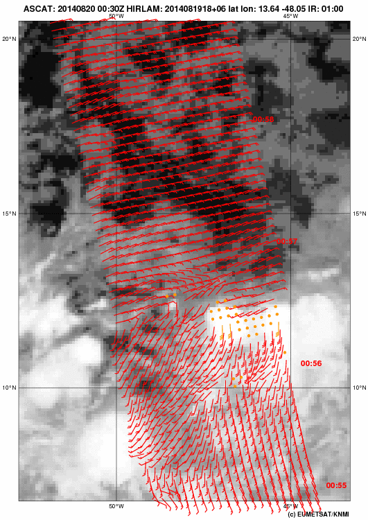
ASCAT missed the latest 0z Best Track position but you can clearly see it still has some time to go to get better organized.

Image
0 likes   

User avatar
Hurricaneman
Category 5
Category 5
Posts: 7281
Age: 43
Joined: Tue Aug 31, 2004 3:24 pm
Location: central florida

Re: ATL: INVEST 96L - Models

#68 Postby Hurricaneman » Tue Aug 19, 2014 9:15 pm

stormlover2013 wrote:Not to early, this thing is going to stay weak until it rides through the carrib...95 percent it's not hitting east coast


Its too early to tell where this is going and thats a strong statement especially since we barely have a low right now and who knows this might run into South America or get destroyed by Hispaniola and never recover so I would wait until this weekend before making any forecast

The posts in this forum are NOT official forecast and should not be used as such. They are just the opinion of the poster and may or may not be backed by sound meteorological data. They are NOT endorsed by any professional institution or storm2k.org. For official information, please refer to the NHC and NWS products
0 likes   

stormlover2013
Category 5
Category 5
Posts: 2312
Joined: Thu Aug 22, 2013 12:06 pm
Location: Lumberton, Texas

Re: ATL: INVEST 96L - Discussion

#69 Postby stormlover2013 » Tue Aug 19, 2014 9:17 pm

All I said it's not a east coast storm, I mean this sucker is pretty low in latitude odds are in favor of a carrib cruiser

Personal Forecast Disclaimer:
The posts in this forum are NOT official forecast and should not be used as such. They are just the opinion of the poster and may or may not be backed by sound meteorological data. They are NOT endorsed by any professional institution or storm2k.org. For official information, please refer to the NHC and NWS products.
0 likes   

User avatar
blp
Category 5
Category 5
Posts: 2805
Age: 45
Joined: Thu Sep 09, 2004 7:51 pm
Location: Miami, FL
Contact:

Re: ATL: INVEST 96L - Discussion

#70 Postby blp » Tue Aug 19, 2014 9:23 pm

I really think the two areas the NHC have mentioned are going to combine to get this going. I see the 850 vorticity sitting around 50W and not moving much and the 500mb vorticity racing over from 42W. I think tomorrow the mid level vort is going to catch up and line up with the low level vort and start the process.

850mb
Image

500mb
Image
0 likes   
The following post is NOT an official forecast and should not be used as such. It is just the opinion of the poster and may or may not be backed by sound meteorological data. It is NOT endorsed by any professional institution including storm2k.org For Official Information please refer to the NHC and NWS products.

User avatar
Hammy
Category 5
Category 5
Posts: 5594
Age: 40
Joined: Fri May 25, 2012 5:25 pm
Contact:

Re: ATL: INVEST 96L - Discussion

#71 Postby Hammy » Tue Aug 19, 2014 9:24 pm

stormlover2013 wrote:All I said it's not a east coast storm, I mean this sucker is pretty low in latitude odds are in favor of a carrib cruiser


I agree that it's way to early to be making such a statement with such certainty. There have been numerous troughs that have been coming off the east coast this summer, more than normal, and all it takes is one well-placed storm and one well-placed opening between troughs to pull this thing up the coast.

http://weather.unisys.com/hurricane/atlantic/1926/1/track.gif If you extrapolate out the beginning part of the track, you'd end up about where 96L is, showing that yes, it can still hit the east coast from where it is.
0 likes   
The above post is not official and should not be used as such. It is the opinion of the poster and may or may not be backed by sound meteorological data. It is not endorsed by any professional institution or storm2k.org. For official information, please refer to the NHC and NWS products.

User avatar
gatorcane
S2K Supporter
S2K Supporter
Posts: 23499
Age: 46
Joined: Sun Mar 13, 2005 3:54 pm
Location: Boca Raton, FL

#72 Postby gatorcane » Tue Aug 19, 2014 9:37 pm

One thing to keep in mind is that we have a large monsoonal gyre out there that stretches from the coast of South America ENE into the central Atlantic. Generally speaking, it takes time for something to form in such a setup and something may not form from exactly where NHC has the Xs. These uncertainties can quite significantly influence the long-term track of this invest.

I also think, like BLP, the two areas will eventually merge into one and form something east of the Leewards somewhere but it will probably take several days for this whole process to occur that could lead to genesis, maybe more like 4-5 days.

The posts in this forum are NOT official forecast and should not be used as such. They are just the opinion of the poster and may or may not be backed by sound meteorological data. They are NOT endorsed by any professional institution or storm2k.org. For official information, please refer to the NHC and NWS products.
Last edited by gatorcane on Tue Aug 19, 2014 9:52 pm, edited 3 times in total.
0 likes   

User avatar
johngaltfla
Category 5
Category 5
Posts: 1938
Joined: Sun Jul 10, 2005 9:17 pm
Location: Sarasota County, FL
Contact:

Re: ATL: INVEST 96L - Discussion

#73 Postby johngaltfla » Tue Aug 19, 2014 9:41 pm

The posts in this forum are NOT official forecast and should not be used as such. They are just the opinion of the poster and may or may not be backed by sound meteorological data. They are NOT endorsed by any professional institution or storm2k.org. For official information, please refer to the NHC and NWS products.

I've been quiet because this season in the Atlantic has been quiet but the SAL has been incredible. Unless that subsides dramatically, I just do not see this storm cranking up until it gets west of Florida.

Thus the wait and see approach, I am not going to get excited just yet.
0 likes   

User avatar
northjaxpro
S2K Supporter
S2K Supporter
Posts: 8900
Joined: Mon Sep 27, 2010 11:21 am
Location: Jacksonville, FL

#74 Postby northjaxpro » Tue Aug 19, 2014 9:43 pm

:uarrow: I'll also add that the GFS and EURO 12Z runs showed a significant weakness off the U.S. East Coast by next week. It was indeed large enough where 96L could get pulled toward the weakness, depending upon how far south it digs.

So, to say definitively that this is not an East Coast system is not a wise thing to do this early in the evolution of 96L. There will be many changes with the models, plus once we get a developed COC to analyze, then we will see more things come into agreement in terms of intensity and track. Lots of time to go before we know where this system goes for certain and how strong 96L will get.
0 likes   
NEVER, EVER SAY NEVER in the tropics and weather in general, and most importantly, with life itself!!

________________________________________________________________________________________

Fay 2008 Beryl 2012 Debby 2012 Colin 2016 Hermine 2016 Julia 2016 Matthew 2016 Irma 2017 Dorian 2019

User avatar
blp
Category 5
Category 5
Posts: 2805
Age: 45
Joined: Thu Sep 09, 2004 7:51 pm
Location: Miami, FL
Contact:

Re:

#75 Postby blp » Tue Aug 19, 2014 9:58 pm

gatorcane wrote:One thing to keep in mind is that we have a large monsoonal gyre out there that stretches from the coast of South America ENE into the central Atlantic. Generally speaking, it takes time for something to form in such a setup and something may not form from exactly where NHC has the Xs. These uncertainties can quite significantly influence the long-term track of this invest.

I also think, like BLP, the two areas will eventually merge into one and form something east of the Leewards somewhere but it will probably take several days for this whole process to occur that could lead to genesis, maybe more like 4-5 days.

The posts in this forum are NOT official forecast and should not be used as such. They are just the opinion of the poster and may or may not be backed by sound meteorological data. They are NOT endorsed by any professional institution or storm2k.org. For official information, please refer to the NHC and NWS products.


It think you are right on point, it will take a while (probably longer than some here would like) to get going. This will be a slow evolution and it is still several days away from the islands. It is going to be interesting to watch it happen. One thing I remember about development from the moonsonal gyre is that they tend to be slow to develop but watch out when they do develop, they are quite the storms.
Last edited by blp on Tue Aug 19, 2014 10:01 pm, edited 1 time in total.
0 likes   
The following post is NOT an official forecast and should not be used as such. It is just the opinion of the poster and may or may not be backed by sound meteorological data. It is NOT endorsed by any professional institution including storm2k.org For Official Information please refer to the NHC and NWS products.

User avatar
somethingfunny
ChatStaff
ChatStaff
Posts: 3926
Age: 35
Joined: Thu May 31, 2007 10:30 pm
Location: McKinney, Texas

Re: ATL: INVEST 96L - Models

#76 Postby somethingfunny » Tue Aug 19, 2014 9:59 pm

CrazyC83 wrote:Am I the only one that gets an Ernesto (2006) vibe on this one?


That's a pretty plausible analog for 96L. The early computer projections also remind me quite a bit of Isaac (2012). It could be anything on the spectrum from absolutely nothing to another 1900 at this point though.
0 likes   
I am not a meteorologist, and any posts made by me are not official forecasts or to be interpreted as being intelligent. These posts are just my opinions and are probably silly opinions.

User avatar
blp
Category 5
Category 5
Posts: 2805
Age: 45
Joined: Thu Sep 09, 2004 7:51 pm
Location: Miami, FL
Contact:

Re: ATL: INVEST 96L - Discussion

#77 Postby blp » Tue Aug 19, 2014 10:11 pm

If you think about it this gyre might be what the doctor ordered for getting things going out there in the MDR. 96l will have such a large moisture envelope that it will hold back the dry air intrusion and sustain the convection whereby a regular type wave storm is going to be fighting that dry air all the way and flaring up and down until it finds better conditions. So this feature is one important factor to this season. Let's see if it sticks around.
0 likes   
The following post is NOT an official forecast and should not be used as such. It is just the opinion of the poster and may or may not be backed by sound meteorological data. It is NOT endorsed by any professional institution including storm2k.org For Official Information please refer to the NHC and NWS products.

User avatar
Steve
S2K Supporter
S2K Supporter
Posts: 8606
Joined: Sat Apr 05, 2003 11:41 pm
Location: Not a state-caster

#78 Postby Steve » Tue Aug 19, 2014 10:44 pm

Of possible interest should 96L get going and should it also make it toward the NW, NC or NE Gulf of Mexico, an upper high is about to set up centered over LA for the next several days which is a first this summer. A lot of the water in the gulf has transitioned into the mid and even upper 80s. And while 4-5 days of mid to upper 90s isn't going to super jack up the shallower waters near the coast, you have to know the temps should at least increase a couple of degrees away from rain and river runoff. I'm not out to hype anything, but farther west in the basin lies a ton of potential. Late August is often a dicey time for the W Caribbean, Straights, Bahamas and Gulf. Bottom line in the giant "if" scenario, I wouldn't bet on something fading too much at landfall
0 likes   

ninel conde
Category 5
Category 5
Posts: 1245
Joined: Mon Aug 04, 2008 2:18 pm

#79 Postby ninel conde » Tue Aug 19, 2014 11:04 pm

i would keep an eye on that large super cane that will be just west of mexico. will be interesting to see if anything could survive the shear from that.
0 likes   
The posts in this forum are NOT official forecast and should not be used as such. They are just the opinion of the poster and may or may not be backed by sound meteorological data. They are NOT endorsed by any professional institution or storm2k.org. For official information, please refer to the NHC and NWS products.

User avatar
Steve
S2K Supporter
S2K Supporter
Posts: 8606
Joined: Sat Apr 05, 2003 11:41 pm
Location: Not a state-caster

#80 Postby Steve » Tue Aug 19, 2014 11:20 pm

Yeah. That could be a super beast. Shear or additional ventilation though, and the possibility of creating high pressure aloft? Relative juxtaposition is important. We saw it before in 1980 (which I don't see as an analog) with Isis and Allen but where the Gulf Storm was the 5.
0 likes   


Return to “2014”

Who is online

Users browsing this forum: No registered users and 113 guests