ATL: CRISTOBAL - Post-Tropical - Discussion

Moderator: S2k Moderators

Message
Author
User avatar
Yellow Evan
Professional-Met
Professional-Met
Posts: 15951
Age: 25
Joined: Fri Jul 15, 2011 12:48 pm
Location: Henderson, Nevada/Honolulu, HI
Contact:

Re:

#81 Postby Yellow Evan » Tue Aug 19, 2014 11:27 pm

Steve wrote:Yeah. That could be a super beast. Shear or additional ventilation though, and the possibility of creating high pressure aloft? Relative juxtaposition is important. We saw it before in 1980 (which I don't see as an analog) with Isis and Allen but where the Gulf Storm was the 5.


Worth poiinting out that in 2004, Ivan and Javier were powerful hurricanes off the west coast of Mexico and the GOM yet nothing happened.
0 likes   

User avatar
Kingarabian
S2K Supporter
S2K Supporter
Posts: 15434
Joined: Sat Aug 08, 2009 3:06 am
Location: Honolulu, Hawaii

Re: Re:

#82 Postby Kingarabian » Tue Aug 19, 2014 11:40 pm

Yellow Evan wrote:
Steve wrote:Yeah. That could be a super beast. Shear or additional ventilation though, and the possibility of creating high pressure aloft? Relative juxtaposition is important. We saw it before in 1980 (which I don't see as an analog) with Isis and Allen but where the Gulf Storm was the 5.


Worth poiinting out that in 2004, Ivan and Javier were powerful hurricanes off the west coast of Mexico and the GOM yet nothing happened.

Probably because the mountains of Mexico are in the way.
0 likes   
RIP Kobe Bryant

floridasun78
Category 5
Category 5
Posts: 3755
Joined: Sun May 17, 2009 10:16 pm
Location: miami fl

Re: ATL: INVEST 96L - Discussion

#83 Postby floridasun78 » Tue Aug 19, 2014 11:46 pm

do 96l weak a bit?
0 likes   

floridasun78
Category 5
Category 5
Posts: 3755
Joined: Sun May 17, 2009 10:16 pm
Location: miami fl

Re: ATL: INVEST 96L - Discussion

#84 Postby floridasun78 » Wed Aug 20, 2014 1:07 am

TROPICAL WEATHER OUTLOOK
NWS NATIONAL HURRICANE CENTER MIAMI FL
200 AM EDT WED AUG 20 2014

For the North Atlantic...Caribbean Sea and the Gulf of Mexico:

1. Shower activity is currently limited in association with an
elongated area of low pressure located several hundred miles east of
the southern Windward Islands. Gradual development of this system
is possible during the next few days while it moves
west-northwestward at 10 to 15 mph across the Lesser Antilles and
into the Caribbean Sea. Interests in the Lesser Antilles should
closely monitor the progress of this system.
* Formation chance through 48 hours...medium...30 percent.
* Formation chance through 5 days...medium...50 percent.
0 likes   

User avatar
SFLcane
S2K Supporter
S2K Supporter
Posts: 9606
Age: 46
Joined: Sat Jun 05, 2010 1:44 pm
Location: Lake Worth Florida

Re: ATL: INVEST 96L - Discussion

#85 Postby SFLcane » Wed Aug 20, 2014 1:14 am

Convection waning this evening...another dried up swirl by morning?
0 likes   

User avatar
meriland23
Category 5
Category 5
Posts: 1239
Age: 36
Joined: Mon Aug 29, 2011 9:29 pm

Re: ATL: INVEST 96L - Discussion

#86 Postby meriland23 » Wed Aug 20, 2014 1:22 am

SFLcane wrote:Convection waining this evening...another dried up swirl by morning?


Possible but I don't think so. Models are supposing it stays weak ..barely hanging on and then booms when it gets into the GOM. But we will see.
0 likes   
The posts in this forum are NOT official forecast and should not be used as such. They are just the opinion of the poster and may or may not be backed by sound meteorological data. They are NOT endorsed by any professional institution or storm2k.org. For official information, please refer to the NHC and NWS products.

User avatar
Hammy
Category 5
Category 5
Posts: 5594
Age: 40
Joined: Fri May 25, 2012 5:25 pm
Contact:

Re: ATL: INVEST 96L - Discussion

#87 Postby Hammy » Wed Aug 20, 2014 1:46 am

SFLcane wrote:Convection waining this evening...another dried up swirl by morning?


Convection is building, although spotty, but monsoonal systems like this (in the Atlantic anyway) don't have consistent convection as there isn't any real organization yet.
0 likes   
The above post is not official and should not be used as such. It is the opinion of the poster and may or may not be backed by sound meteorological data. It is not endorsed by any professional institution or storm2k.org. For official information, please refer to the NHC and NWS products.

User avatar
chaser1
S2K Supporter
S2K Supporter
Posts: 4681
Age: 63
Joined: Sat Oct 15, 2005 5:59 pm
Location: Longwood, Fl

Re: ATL: INVEST 96L - Discussion

#88 Postby chaser1 » Wed Aug 20, 2014 2:03 am

I personally think that 96L was prematurely tagged, and that the disturbance rolling westward to its east is the "real deal"
0 likes   
Personal Forecast Disclaimer:
The posts in this forum are NOT official forecast and should not be used as such. They are just the opinion of the poster and may or may not be backed by sound meteorological data. They are NOT endorsed by any professional institution or storm2k.org. For official information, please refer to the NHC and NWS products.


User avatar
latitude_20
Tropical Storm
Tropical Storm
Posts: 196
Joined: Wed Jun 30, 2010 6:46 am
Location: Tulum, Mexico
Contact:

Re: ATL: INVEST 96L - Discussion

#89 Postby latitude_20 » Wed Aug 20, 2014 2:38 am

SFLcane wrote:Convection waining this evening...another dried up swirl by morning?


Not likely. Read Gatorcane's post upthread. It's buried in the monsoon gyre right now, and most systems that develop in this region take their own sweet time.
0 likes   

User avatar
LaBreeze
Category 5
Category 5
Posts: 1497
Joined: Thu Sep 04, 2003 1:57 pm
Location: SW Louisiana

Re: ATL: INVEST 96L - Discussion

#90 Postby LaBreeze » Wed Aug 20, 2014 2:49 am

meriland23 wrote:
SFLcane wrote:Convection waining this evening...another dried up swirl by morning?


Possible but I don't think so. Models are supposing it stays weak ..barely hanging on and then booms when it gets into the GOM. But we will see.


I'd love to see a dried up swirl, but I'm afraid that I may have to agree with meriland23 at this time. Too early to tell and yet I'm a bit concerned because I live in SW LA and have plans for Labor Day in Biloxi. I'll be watching this one closely (as I always do).
0 likes   
Audrey (1957), Carla (1961), Hilda (1964), Betsy (1965), Edith (1971), Carmen (1974), Danny (1985), Juan (1985), Andrew (1992), Lili (2002), Rita (2005), Gustav (2008), Ike (2008), and stuck in the eye of Iniki (1992) while vacationing in Kauai.

Not an official forecast by any means.

User avatar
ObsessedMiami
Category 1
Category 1
Posts: 413
Joined: Tue Aug 31, 2004 8:08 pm
Location: West Kendall, Fl

Re: ATL: INVEST 96L - Discussion

#91 Postby ObsessedMiami » Wed Aug 20, 2014 5:08 am

http://www.drroyspencer.com/2014/08/new-orleans-hurricane-exactly-9-years-after-katrina/

I don't know who Dr. Roy Spencer is, but to put out a blog post suggesting that 96L will hit New Orleans as a hurricane using one run from the GFS ensemble is irresponsible.

Edit: I see now it's some kind of crank anti global warning site but it is being picked up by news services
0 likes   

User avatar
Gustywind
Category 5
Category 5
Posts: 12334
Joined: Mon Sep 03, 2007 7:29 am
Location: Baie-Mahault, GUADELOUPE

#92 Postby Gustywind » Wed Aug 20, 2014 5:23 am

TROPICAL WEATHER DISCUSSION
NWS NATIONAL HURRICANE CENTER MIAMI FL
205 AM EDT WED AUG 20 2014


...SPECIAL FEATURES...
A 1009 MB LOW IS CENTERED NEAR 10N52W AND REMAINS EMBEDDED
WITHIN LOW-LEVEL CYCLONIC MONSOONAL FLOW ACROSS THE CENTRAL
TROPICAL ATLC. A TROPICAL WAVE TO THE EAST-NORTHEAST OF THE LOW
IS EXPECTED TO INJECT ENERGY INTO THE LOW DURING THE NEXT 24 TO
48 HOURS WITH MOST GLOBAL MODELS SUGGESTING DEVELOPMENT OF THE
SURFACE LOW
THAT TRACKS W-NW TOWARD THE LEEWARD ISLANDS AND NE
CARIBBEAN BY FRIDAY. ISOLATED MODERATE CONVECTION IS FROM 06N-
13N BETWEEN 50W-56W.
0 likes   

User avatar
wxman57
Moderator-Pro Met
Moderator-Pro Met
Posts: 22480
Age: 66
Joined: Sat Jun 21, 2003 8:06 pm
Location: Houston, TX (southwest)

Re: ATL: INVEST 96L - Discussion

#93 Postby wxman57 » Wed Aug 20, 2014 5:40 am

Still no hint of rotation. Certainly no development within 48 hrs and probably not for another 4-5 days. Models have it making a 90-deg turn to the right this morning - not likely.
0 likes   

User avatar
wxman57
Moderator-Pro Met
Moderator-Pro Met
Posts: 22480
Age: 66
Joined: Sat Jun 21, 2003 8:06 pm
Location: Houston, TX (southwest)

Re: ATL: INVEST 96L - Discussion

#94 Postby wxman57 » Wed Aug 20, 2014 5:43 am

ObsessedMiami wrote:http://www.drroyspencer.com/2014/08/new-orleans-hurricane-exactly-9-years-after-katrina/

I don't know who Dr. Roy Spencer is, but to put out a blog post suggesting that 96L will hit New Orleans as a hurricane using one run from the GFS ensemble is irresponsible.

Edit: I see now it's some kind of crank anti global warning site but it is being picked up by news services


You should read the article again. There is no suggestion that 96L will strike New Orleans as a hurricane. He says: "Of course, this far in advance, the hurricane (even if it forms) could make landfall anywhere along the Gulf coast. I just though the timing, exactly 9 years after Katrina, was interesting."
0 likes   

User avatar
ObsessedMiami
Category 1
Category 1
Posts: 413
Joined: Tue Aug 31, 2004 8:08 pm
Location: West Kendall, Fl

Re: ATL: INVEST 96L - Discussion

#95 Postby ObsessedMiami » Wed Aug 20, 2014 5:55 am

wxman57 wrote:
ObsessedMiami wrote:http://www.drroyspencer.com/2014/08/new-orleans-hurricane-exactly-9-years-after-katrina/

I don't know who Dr. Roy Spencer is, but to put out a blog post suggesting that 96L will hit New Orleans as a hurricane using one run from the GFS ensemble is irresponsible.

Edit: I see now it's some kind of crank anti global warning site but it is being picked up by news services


You should read the article again. There is no suggestion that 96L will strike New Orleans as a hurricane. He says: "Of course, this far in advance, the hurricane (even if it forms) could make landfall anywhere along the Gulf coast. I just though the timing, exactly 9 years after Katrina, was interesting."

"It’s still over a week away, but a tropical disturbance east of the Lesser Antilles is being forecast by the GFS model to grow into a hurricane, making landfall near New Orleans just 1 day before the 9th anniversary of Katrina’s landfall"

Especially if you don't know what the GFS is and don't read more than that paragraph, since it's above the graphics break, it seems a suggestion to me, especially since it's being directed there by a news site with that line as the headline.
0 likes   

User avatar
cycloneye
Admin
Admin
Posts: 139067
Age: 67
Joined: Thu Oct 10, 2002 10:54 am
Location: San Juan, Puerto Rico

Re: ATL: INVEST 96L - Discussion

#96 Postby cycloneye » Wed Aug 20, 2014 6:19 am

8:05 AM EDT Special Feature discussion. Interesting about the wave behind.

...SPECIAL FEATURES...
A 1009 MB LOW IS CENTERED NEAR 10N53W AND REMAINS EMBEDDED
WITHIN LOW-LEVEL CYCLONIC MONSOONAL FLOW ACROSS THE TROPICAL
ATLC. A TROPICAL WAVE TO THE EAST-NORTHEAST OF THE LOW IS
EXPECTED TO INJECT ENERGY INTO THE LOW DURING THE NEXT 24 TO 48
HOURS
WITH MOST GLOBAL MODELS SUGGESTING DEVELOPMENT OF THE
SURFACE LOW THAT TRACKS W-NW TOWARD THE LEEWARD ISLANDS AND NE
CARIBBEAN BY FRIDAY. WIDELY SCATTERED MODERATE CONVECTION IS
FROM 06N-12N BETWEEN 51W-57W.
0 likes   
Visit the Caribbean-Central America Weather Thread where you can find at first post web cams,radars
and observations from Caribbean basin members Click Here

User avatar
cycloneye
Admin
Admin
Posts: 139067
Age: 67
Joined: Thu Oct 10, 2002 10:54 am
Location: San Juan, Puerto Rico

Re: ATL: INVEST 96L - Discussion

#97 Postby cycloneye » Wed Aug 20, 2014 6:44 am

Disorganized shower and thunderstorm activity is associated with
an elongated area of low pressure located several hundred miles east
of the southern Windward Islands. Gradual development of this
system is possible during the next few days while it moves west-
northwestward at 10 to 15 mph across the Lesser Antilles and
into the Caribbean Sea. Interests in the Lesser Antilles and
the northeastern Caribbean Sea should closely monitor the progress
of this system.
* Formation chance through 48 hours...medium...30 percent.
* Formation chance through 5 days...medium...50 percent.
0 likes   
Visit the Caribbean-Central America Weather Thread where you can find at first post web cams,radars
and observations from Caribbean basin members Click Here

jlauderdal
S2K Supporter
S2K Supporter
Posts: 6771
Joined: Wed May 19, 2004 5:46 am
Location: NE Fort Lauderdale
Contact:

Re: ATL: INVEST 96L - Discussion

#98 Postby jlauderdal » Wed Aug 20, 2014 7:02 am

ObsessedMiami wrote:http://www.drroyspencer.com/2014/08/new-orleans-hurricane-exactly-9-years-after-katrina/

I don't know who Dr. Roy Spencer is, but to put out a blog post suggesting that 96L will hit New Orleans as a hurricane using one run from the GFS ensemble is irresponsible.

Edit: I see now it's some kind of crank anti global warning site but it is being picked up by news services


the good doctor only reported what the gfs was showing, wasnt his personal forecast

http://en.wikipedia.org/wiki/Roy_Spencer_(scientist)

he went to uw-madison so that is always a plus in the weather dept... :wink:
0 likes   

User avatar
NDG
S2K Supporter
S2K Supporter
Posts: 14933
Joined: Sun Jul 09, 2006 10:14 pm
Location: Orlando, FL

#99 Postby NDG » Wed Aug 20, 2014 7:05 am

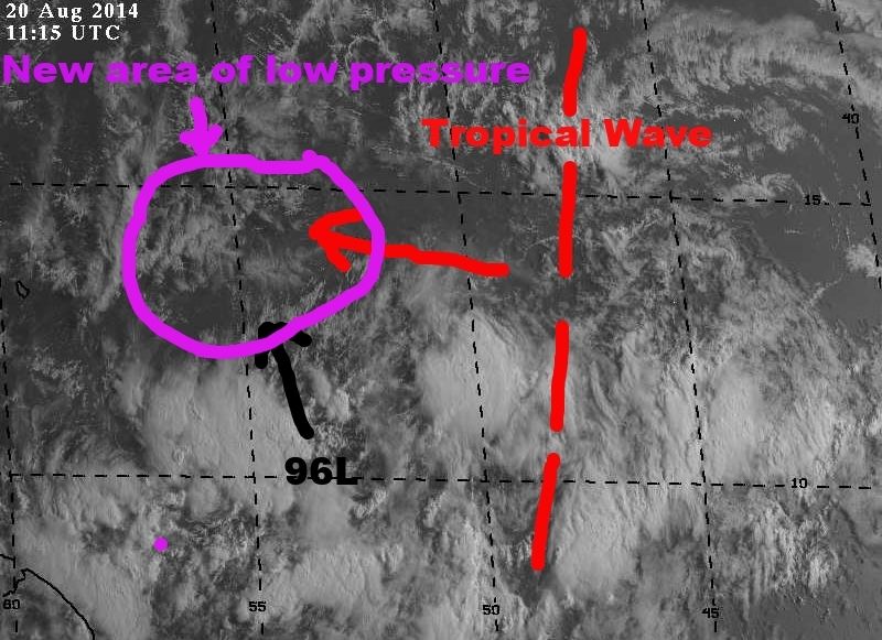
This is what is basically is going to be happening over the next 24-48 hrs as suggested by the HWRF and European model, 96L is not going to do much until the TW behind it catches up to it and a new area of low pressure reforms further north, IMO.

Image
Last edited by NDG on Wed Aug 20, 2014 7:28 am, edited 2 times in total.
0 likes   

jlauderdal
S2K Supporter
S2K Supporter
Posts: 6771
Joined: Wed May 19, 2004 5:46 am
Location: NE Fort Lauderdale
Contact:

Re: ATL: INVEST 96L - Discussion

#100 Postby jlauderdal » Wed Aug 20, 2014 7:06 am

wxman57 wrote:Still no hint of rotation. Certainly no development within 48 hrs and probably not for another 4-5 days. Models have it making a 90-deg turn to the right this morning - not likely.

if this verifies then we have 4-5 days of tensions rising on this board :roll: ..happy hurricane hunting

90 degree turn would be cool but like you said, unlikely at best especially in this setup
0 likes   


Return to “2014”

Who is online

Users browsing this forum: No registered users and 114 guests