
ATL: DOLLY - Models
Moderator: S2k Moderators


Re: ATL: Ex INVEST 97L - Models
What is that storm further east? That one looks a bit worrisome.
0 likes
-
gatorcane

- S2K Supporter

- Posts: 23499
- Age: 46
- Joined: Sun Mar 13, 2005 3:54 pm
- Location: Boca Raton, FL
Re: ATL: Ex INVEST 97L - Models
HeeBGBz wrote:What is that storm further east? That one looks a bit worrisome.
Here is the thread:
viewtopic.php?f=31&t=116663
0 likes
-
Hurricaneman

- Category 5

- Posts: 7282
- Age: 43
- Joined: Tue Aug 31, 2004 3:24 pm
- Location: central florida
The 12zGFS moves this into the BOC and stalls it here for like 9 days before finally moving it NE after that, I seriously doubt thats going to happen as the GFS likes to stall things there longer than reality dictates
The posts in this forum are NOT official forecast and should not be used as such. They are just the opinion of the poster and may or may not be backed by sound meteorological data. They are NOT endorsed by any professional institution or storm2k.org. For official information, please refer to the NHC and NWS products
The posts in this forum are NOT official forecast and should not be used as such. They are just the opinion of the poster and may or may not be backed by sound meteorological data. They are NOT endorsed by any professional institution or storm2k.org. For official information, please refer to the NHC and NWS products
0 likes
-
northjaxpro

- S2K Supporter
- Posts: 8900
- Joined: Mon Sep 27, 2010 11:21 am
- Location: Jacksonville, FL
Re:
Hurricaneman wrote:The 12zGFS moves this into the BOC and stalls it here for like 9 days before finally moving it NE after that, I seriously doubt thats going to happen as the GFS likes to stall things there longer than reality dictates
The posts in this forum are NOT official forecast and should not be used as such. They are just the opinion of the poster and may or may not be backed by sound meteorological data. They are NOT endorsed by any professional institution or storm2k.org. For official information, please refer to the NHC and NWS products
Yeah, I doubt very much that if this system, if it develops, gets buried down into the BOC like the GFS wants to do. Now, I recognize that systems have stalled down there and it is not uncommon for sure. But, the models I like to also see (EURO and UKMET) all show impressive deep layered ridging across the SE U.S. going into next week and with that set up, I would definitely be inclined to go with this system eventually headed for Northern Mexico down the road next week.
_______________________
The posts in this forum are NOT official forecast. They are just the opinion of the poster. For official information, please refer to the NHC and NWS products
Last edited by northjaxpro on Thu Aug 28, 2014 2:53 pm, edited 2 times in total.
0 likes
NEVER, EVER SAY NEVER in the tropics and weather in general, and most importantly, with life itself!!
________________________________________________________________________________________
Fay 2008 Beryl 2012 Debby 2012 Colin 2016 Hermine 2016 Julia 2016 Matthew 2016 Irma 2017 Dorian 2019
________________________________________________________________________________________
Fay 2008 Beryl 2012 Debby 2012 Colin 2016 Hermine 2016 Julia 2016 Matthew 2016 Irma 2017 Dorian 2019
-
tropicwatch

- Category 5
- Posts: 3205
- Age: 60
- Joined: Sat Jun 02, 2007 10:01 am
- Location: Panama City Florida
- Contact:
It wasn't nine days but similar to an Eloise 75' situation.
0 likes
Tropicwatch
Agnes 72', Eloise 75, Elena 85', Kate 85', Charley 86', Florence 88', Beryl 94', Dean 95', Erin 95', Opal 95', Earl 98', Georges 98', Ivan 2004', Arlene 2005', Dennis 2005', Ida 2009' Debby 2012' Irma 2017' Michael 2018'
Agnes 72', Eloise 75, Elena 85', Kate 85', Charley 86', Florence 88', Beryl 94', Dean 95', Erin 95', Opal 95', Earl 98', Georges 98', Ivan 2004', Arlene 2005', Dennis 2005', Ida 2009' Debby 2012' Irma 2017' Michael 2018'
-
Hurricaneman
- Category 5
- Posts: 7282
- Age: 43
- Joined: Tue Aug 31, 2004 3:24 pm
- Location: central florida
Re:
panamatropicwatch wrote:It wasn't nine days but similar to an Eloise 75' situation.
This could happen if the trough hasn't completely lifted out as it develops but no model at this time depicts this scenerio
The posts in this forum are NOT official forecast and should not be used as such. They are just the opinion of the poster and may or may not be backed by sound meteorological data. They are NOT endorsed by any professional institution or storm2k.org. For official information, please refer to the NHC and NWS products
0 likes
-
Rgv20

- S2K Supporter
- Posts: 2456
- Age: 37
- Joined: Wed Jan 05, 2011 5:42 pm
- Location: Edinburg/McAllen Tx
0zNAM agrees with the GFS and CMC and a possible TC in the BOC early next week....Just remember that the NAM is not a tropical model just posting for fun!
0zNAM 84hrs
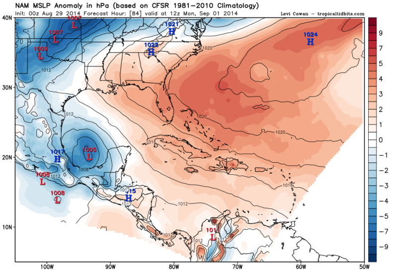
0zNAM 84hrs

0 likes
The following post is NOT an official forecast and should not be used as such. It is just the opinion of the poster and may or may not be backed by sound meteorological data. It is NOT endorsed by any professional institution including storm2k.org For Official Information please refer to the NHC and NWS products.
-
Rgv20
- S2K Supporter
- Posts: 2456
- Age: 37
- Joined: Wed Jan 05, 2011 5:42 pm
- Location: Edinburg/McAllen Tx
0zCMC back to its old tricks!
132hrs
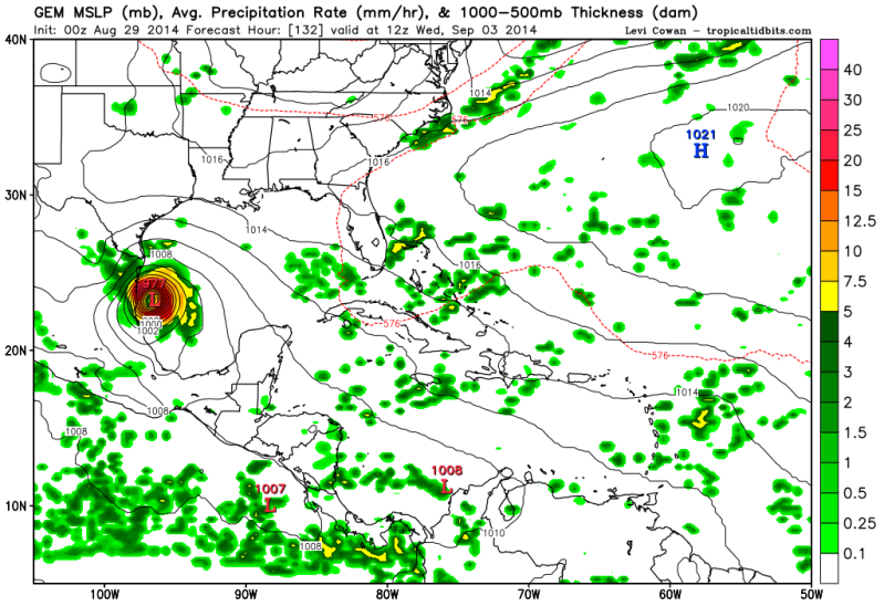
132hrs

0 likes
The following post is NOT an official forecast and should not be used as such. It is just the opinion of the poster and may or may not be backed by sound meteorological data. It is NOT endorsed by any professional institution including storm2k.org For Official Information please refer to the NHC and NWS products.

Re: ATL: Ex INVEST 97L - Models
HeeBGBz wrote:Thanks Gatorcane. There are things popping up all over.
You have to thing something has to come of all this eventually!
0 likes
Andrew '92 Opal '95 Blizzard '96 Izzy '03 Irene '11 Sandy '12
The following post is NOT an official forecast and should not be used as such. It is just the opinion is not be backed by sound meteorological data. It is NOT endorsed by any professional institution including storm2k.org For Official Information please refer to the NHC and NWS products.
The following post is NOT an official forecast and should not be used as such. It is just the opinion is not be backed by sound meteorological data. It is NOT endorsed by any professional institution including storm2k.org For Official Information please refer to the NHC and NWS products.

-
cycloneye

- Admin

- Posts: 139163
- Age: 67
- Joined: Thu Oct 10, 2002 10:54 am
- Location: San Juan, Puerto Rico
Re: ATL: INVEST 99L - Models
TROPICAL CYCLONE GUIDANCE MESSAGE
NWS NATIONAL HURRICANE CENTER MIAMI FL
0033 UTC SAT AUG 30 2014
DISCLAIMER...NUMERICAL MODELS ARE SUBJECT TO LARGE ERRORS.
PLEASE REFER TO NHC OFFICIAL FORECASTS FOR TROPICAL CYCLONE
AND SUBTROPICAL CYCLONE INFORMATION.
ATLANTIC OBJECTIVE AIDS FOR
DISTURBANCE INVEST (AL992014) 20140830 0000 UTC
...00 HRS... ...12 HRS... ...24 HRS... ...36 HRS...
140830 0000 140830 1200 140831 0000 140831 1200
LAT LON LAT LON LAT LON LAT LON
BAMS 15.1N 80.9W 16.1N 83.8W 17.3N 86.6W 18.4N 89.4W
BAMD 15.1N 80.9W 15.8N 83.1W 16.5N 85.0W 17.2N 86.8W
BAMM 15.1N 80.9W 16.1N 83.4W 17.0N 85.7W 17.9N 88.0W
LBAR 15.1N 80.9W 15.9N 83.3W 16.9N 85.8W 18.2N 88.3W
SHIP 20KTS 24KTS 32KTS 40KTS
DSHP 20KTS 24KTS 32KTS 40KTS
...48 HRS... ...72 HRS... ...96 HRS... ..120 HRS...
140901 0000 140902 0000 140903 0000 140904 0000
LAT LON LAT LON LAT LON LAT LON
BAMS 19.4N 91.7W 20.5N 95.4W 20.6N 97.8W 20.6N 100.5W
BAMD 17.8N 88.5W 19.0N 91.5W 19.7N 94.0W 20.5N 97.2W
BAMM 18.6N 90.0W 19.6N 93.4W 20.1N 96.1W 20.6N 99.2W
LBAR 19.5N 90.6W 22.4N 94.7W 24.5N 97.3W 26.5N 99.9W
SHIP 50KTS 66KTS 77KTS 85KTS
DSHP 30KTS 43KTS 54KTS 31KTS
...INITIAL CONDITIONS...
LATCUR = 15.1N LONCUR = 80.9W DIRCUR = 280DEG SPDCUR = 10KT
LATM12 = 14.7N LONM12 = 79.0W DIRM12 = 282DEG SPDM12 = 10KT
LATM24 = 14.4N LONM24 = 77.0W
WNDCUR = 20KT RMAXWD = 40NM WNDM12 = 20KT
CENPRS = 1009MB OUTPRS = 1010MB OUTRAD = 150NM SDEPTH = S
RD34NE = 0NM RD34SE = 0NM RD34SW = 0NM RD34NW = 0NM
0 likes
Visit the Caribbean-Central America Weather Thread where you can find at first post web cams,radars
and observations from Caribbean basin members Click Here
and observations from Caribbean basin members Click Here
-
bamajammer4eva
- Category 4

- Posts: 907
- Joined: Sun Apr 18, 2010 3:21 am
- Location: Ozark, AL

-
Rgv20
- S2K Supporter
- Posts: 2456
- Age: 37
- Joined: Wed Jan 05, 2011 5:42 pm
- Location: Edinburg/McAllen Tx
0zNAM 84hrs

0 likes
The following post is NOT an official forecast and should not be used as such. It is just the opinion of the poster and may or may not be backed by sound meteorological data. It is NOT endorsed by any professional institution including storm2k.org For Official Information please refer to the NHC and NWS products.
-
Rgv20
- S2K Supporter
- Posts: 2456
- Age: 37
- Joined: Wed Jan 05, 2011 5:42 pm
- Location: Edinburg/McAllen Tx
Don't fear the 0zNAM is here!!
0zNAM 75hrs
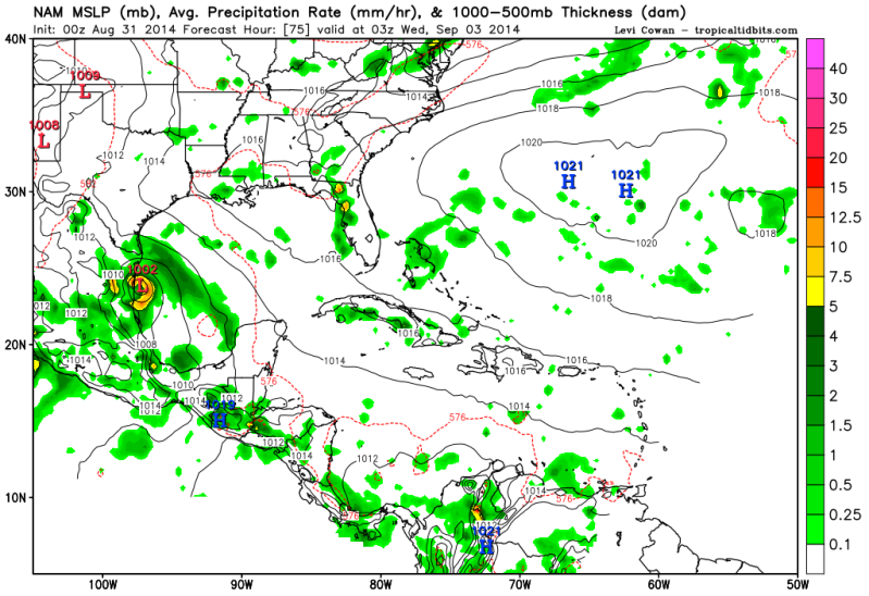
0zNAM 75hrs

0 likes
The following post is NOT an official forecast and should not be used as such. It is just the opinion of the poster and may or may not be backed by sound meteorological data. It is NOT endorsed by any professional institution including storm2k.org For Official Information please refer to the NHC and NWS products.
-
TheStormExpert

- Category 5
- Posts: 8487
- Age: 30
- Joined: Wed Feb 16, 2011 5:38 pm
- Location: Palm Beach Gardens, FL
Re:
Rgv20 wrote:Don't fear the 0zNAM is here!!
0zNAM 75hrs
(For Entertainment Purposes Only)
0 likes
The following post is NOT an official forecast and should not be used as such. It is just the opinion of the poster and may or may not be backed by sound meteorological data. It is NOT endorsed by storm2k.org.
Who is online
Users browsing this forum: No registered users and 49 guests