ATL: DOLLY - Models

Moderator: S2k Moderators

Message
Author
User avatar
meriland23
Category 5
Category 5
Posts: 1239
Age: 36
Joined: Mon Aug 29, 2011 9:29 pm

Re: ATL: INVEST 97L - Models

#61 Postby meriland23 » Tue Aug 26, 2014 6:38 am

Just want to point this out...

CMC 00z

Image
0 likes   
The posts in this forum are NOT official forecast and should not be used as such. They are just the opinion of the poster and may or may not be backed by sound meteorological data. They are NOT endorsed by any professional institution or storm2k.org. For official information, please refer to the NHC and NWS products.

tolakram
Admin
Admin
Posts: 19165
Age: 60
Joined: Sun Aug 27, 2006 8:23 pm
Location: Florence, KY (name is Mark)

Re: ATL: INVEST 97L - Models

#62 Postby tolakram » Tue Aug 26, 2014 7:14 am

:uarrow: still in fantasy land, fortunately.

The GFS does show this wave entering the Bahamas as a weak storm or low at 180 hours.

Image
0 likes   
M a r k
- - - - -
Join us in chat: Storm2K Chatroom Invite. Android and IOS apps also available.

The posts in this forum are NOT official forecasts and should not be used as such. Posts are NOT endorsed by any professional institution or STORM2K.org. For official information and forecasts, please refer to NHC and NWS products.

User avatar
gatorcane
S2K Supporter
S2K Supporter
Posts: 23499
Age: 46
Joined: Sun Mar 13, 2005 3:54 pm
Location: Boca Raton, FL

#63 Postby gatorcane » Tue Aug 26, 2014 2:29 pm

12Z guidance continues to show this wave in the vicinity the Bahamas around a week from now with the GFS a little north of the rest of the global models and slower while the ECMWF is the fastest and further south but not as south as the GEM guidance. None of the global models are making it strong but we are still far out.
0 likes   

Frank2
Category 5
Category 5
Posts: 4061
Joined: Mon Jul 25, 2005 12:47 pm

Re: ATL: INVEST 97L - Models

#64 Postby Frank2 » Tue Aug 26, 2014 3:21 pm

After the Cristobal model scare some might be hesitant to believe them so soon - as you said the GFS doesn't indicate anything too interesting...
0 likes   

User avatar
gatorcane
S2K Supporter
S2K Supporter
Posts: 23499
Age: 46
Joined: Sun Mar 13, 2005 3:54 pm
Location: Boca Raton, FL

#65 Postby gatorcane » Tue Aug 26, 2014 9:24 pm

18Z global models are rather lackluster on this developing, let's see what the overnight runs show.
0 likes   

User avatar
N2FSU
S2K Supporter
S2K Supporter
Posts: 1010
Joined: Thu Sep 04, 2003 2:04 pm
Location: Tallahassee, FL

Global Model Runs Discussion

#66 Postby N2FSU » Wed Aug 27, 2014 10:55 am

12Z GFS +72: SW Caribbean looks like it's cranking up

Image
0 likes   

User avatar
N2FSU
S2K Supporter
S2K Supporter
Posts: 1010
Joined: Thu Sep 04, 2003 2:04 pm
Location: Tallahassee, FL

Re: Global Model Runs Discussion

#67 Postby N2FSU » Wed Aug 27, 2014 11:17 am

12Z GFS +96

Image
0 likes   

User avatar
N2FSU
S2K Supporter
S2K Supporter
Posts: 1010
Joined: Thu Sep 04, 2003 2:04 pm
Location: Tallahassee, FL

Re: Global Model Runs Discussion

#68 Postby N2FSU » Wed Aug 27, 2014 11:20 am

+144Image
0 likes   

User avatar
cycloneye
Admin
Admin
Posts: 139087
Age: 67
Joined: Thu Oct 10, 2002 10:54 am
Location: San Juan, Puerto Rico

Re: ATL: Ex INVEST 97L - Models

#69 Postby cycloneye » Wed Aug 27, 2014 11:35 am

168 hours.

Image
0 likes   
Visit the Caribbean-Central America Weather Thread where you can find at first post web cams,radars
and observations from Caribbean basin members Click Here

User avatar
cycloneye
Admin
Admin
Posts: 139087
Age: 67
Joined: Thu Oct 10, 2002 10:54 am
Location: San Juan, Puerto Rico

Re: ATL: Ex INVEST 97L - Models

#70 Postby cycloneye » Wed Aug 27, 2014 11:47 am

12z GFS has landfall in Mexico at 180 hours.

Image
0 likes   
Visit the Caribbean-Central America Weather Thread where you can find at first post web cams,radars
and observations from Caribbean basin members Click Here

User avatar
Portastorm
Storm2k Moderator
Storm2k Moderator
Posts: 9787
Age: 61
Joined: Fri Jul 11, 2003 9:16 am
Location: South Austin, TX
Contact:

Re: ATL: Ex INVEST 97L - Models

#71 Postby Portastorm » Wed Aug 27, 2014 11:50 am

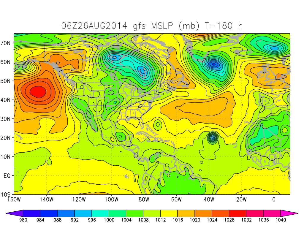
cycloneye wrote:12z GFS has landfall in Mexico at 180 hours.

Image


Yep ... a Tampico especial.
0 likes   
Any forecasts under my name are to be taken with a grain of salt. Get your best forecasts from the National Weather Service and National Hurricane Center.

I'm a certified Advanced SKYWARN-trained spotter and am active on Twitter at @TravisCOSW, a social media partner of the NWS Austin-San Antonio office.

User avatar
PTrackerLA
Category 5
Category 5
Posts: 5248
Age: 40
Joined: Thu Oct 10, 2002 8:40 pm
Location: Lafayette, LA

Re: ATL: Ex INVEST 97L - Models

#72 Postby PTrackerLA » Wed Aug 27, 2014 11:55 am

GFS has been very consistent on this solution of a Mexican landfall. Seems like we see this setup occur nearly every season and there doesn't seem to be much to steer this further north with High Pressure over the gulf coast. Still something to watch out over the next several days.
0 likes   

Alyono
Professional-Met
Professional-Met
Posts: 6961
Joined: Fri Apr 26, 2013 3:52 pm
Location: Texas Coast

#73 Postby Alyono » Wed Aug 27, 2014 12:13 pm

canadian keeps it farther south, barely bringing it over the water. as a result, we have a TD/weak ts
0 likes   

User avatar
N2FSU
S2K Supporter
S2K Supporter
Posts: 1010
Joined: Thu Sep 04, 2003 2:04 pm
Location: Tallahassee, FL

Re: ATL: Ex INVEST 97L - Models

#74 Postby N2FSU » Wed Aug 27, 2014 12:30 pm

Seems hard to believe that with the persistent east coast trough the past few months, that one wouldn't swing through as we enter September to move this at least a little more north.
0 likes   

User avatar
gatorcane
S2K Supporter
S2K Supporter
Posts: 23499
Age: 46
Joined: Sun Mar 13, 2005 3:54 pm
Location: Boca Raton, FL

#75 Postby gatorcane » Wed Aug 27, 2014 1:42 pm

NAVGEM send its up to near Florida but doesn't see as much ridging as the other global models and doesn't seem like it will verify:

Image
0 likes   

Dean4Storms
S2K Supporter
S2K Supporter
Posts: 6355
Age: 61
Joined: Sun Aug 31, 2003 1:01 pm
Location: Miramar Bch. FL

#76 Postby Dean4Storms » Wed Aug 27, 2014 3:14 pm

Well you do have to ask yourself how many times out 180 hours does any model get the right landfall location on something it is forecasting to develop. So yes, this could change!
0 likes   

bamajammer4eva
Category 4
Category 4
Posts: 907
Joined: Sun Apr 18, 2010 3:21 am
Location: Ozark, AL

Re: ATL: Ex INVEST 97L - Models

#77 Postby bamajammer4eva » Wed Aug 27, 2014 6:01 pm

18z GFS keeps it weak and dancing around in the BOC through 384 hrs

Image
0 likes   

User avatar
Rgv20
S2K Supporter
S2K Supporter
Posts: 2456
Age: 37
Joined: Wed Jan 05, 2011 5:42 pm
Location: Edinburg/McAllen Tx

#78 Postby Rgv20 » Wed Aug 27, 2014 11:43 pm

GFS has been consistent on sending a TC to the Tampico area by sometime next week..

0zGFS 144hrs
Image

0zGFS 180hrs
Image
0 likes   
The following post is NOT an official forecast and should not be used as such. It is just the opinion of the poster and may or may not be backed by sound meteorological data. It is NOT endorsed by any professional institution including storm2k.org For Official Information please refer to the NHC and NWS products.

User avatar
Rgv20
S2K Supporter
S2K Supporter
Posts: 2456
Age: 37
Joined: Wed Jan 05, 2011 5:42 pm
Location: Edinburg/McAllen Tx

#79 Postby Rgv20 » Thu Aug 28, 2014 12:23 am

GFS still has support of the CMC..

0zCMC 156hrs
Image


0zGFS Ensembles 180hrs...There are quite a few Ensemble Members showing a TC..
Image
0 likes   
The following post is NOT an official forecast and should not be used as such. It is just the opinion of the poster and may or may not be backed by sound meteorological data. It is NOT endorsed by any professional institution including storm2k.org For Official Information please refer to the NHC and NWS products.

USTropics
Category 5
Category 5
Posts: 2414
Joined: Sun Aug 12, 2007 3:45 am
Location: Florida State University

Re: ATL: Ex INVEST 97L - Models

#80 Postby USTropics » Thu Aug 28, 2014 3:40 am

0z ECMWF also in agreement with the GFS on bringing the vorticity maximum associated with ex 97L into Mexico in 144 hours. Strength seems to be comparable to the GFS as well, with a messy, elongated system.

Image
0 likes   


Return to “2014”

Who is online

Users browsing this forum: No registered users and 104 guests