ATL: INVEST 90L - Discussion

Moderator: S2k Moderators

Message
Author
User avatar
LaBreeze
Category 5
Category 5
Posts: 1497
Joined: Thu Sep 04, 2003 1:57 pm
Location: SW Louisiana

Re: ATL: INVEST 90L - Discussion

#141 Postby LaBreeze » Sat Sep 06, 2014 4:38 pm

sunnyday wrote:Isn't this one likely to go the way of the others this season? If not, please explain.
Thank you....


I'm thinking like sunnyday - is this expected to be an East Coast scare or a fish?
0 likes   
Audrey (1957), Carla (1961), Hilda (1964), Betsy (1965), Edith (1971), Carmen (1974), Danny (1985), Juan (1985), Andrew (1992), Lili (2002), Rita (2005), Gustav (2008), Ike (2008), and stuck in the eye of Iniki (1992) while vacationing in Kauai.

Not an official forecast by any means.

User avatar
Hammy
Category 5
Category 5
Posts: 5594
Age: 40
Joined: Fri May 25, 2012 5:25 pm
Contact:

Re: ATL: INVEST 90L - Discussion

#142 Postby Hammy » Sat Sep 06, 2014 4:55 pm

LaBreeze wrote:
sunnyday wrote:Isn't this one likely to go the way of the others this season? If not, please explain.
Thank you....


I'm thinking like sunnyday - is this expected to be an East Coast scare or a fish?


I'd lean towards out to sea myself--after Cristobal, I'm not putting any stock in the long-range models that show a westward track.

edit:
Image

my take based on cloud motion of where the (likely somewhat elongated) center is at and apparent wind flow (at least at cloud level)
Last edited by Hammy on Sat Sep 06, 2014 4:57 pm, edited 1 time in total.
0 likes   
The above post is not official and should not be used as such. It is the opinion of the poster and may or may not be backed by sound meteorological data. It is not endorsed by any professional institution or storm2k.org. For official information, please refer to the NHC and NWS products.

floridasun78
Category 5
Category 5
Posts: 3755
Joined: Sun May 17, 2009 10:16 pm
Location: miami fl

#143 Postby floridasun78 » Sat Sep 06, 2014 5:04 pm

i see shear near islands north of leedwards
0 likes   

ozonepete
Professional-Met
Professional-Met
Posts: 4743
Joined: Mon Sep 07, 2009 3:23 pm
Location: From Ozone Park, NYC / Now in Brooklyn, NY

Re: ATL: INVEST 90L - Discussion

#144 Postby ozonepete » Sat Sep 06, 2014 5:08 pm

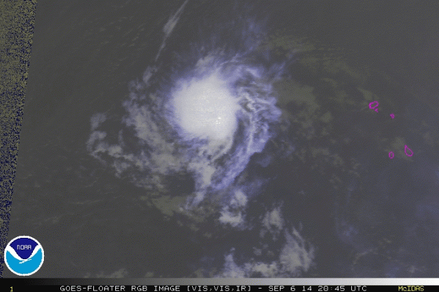
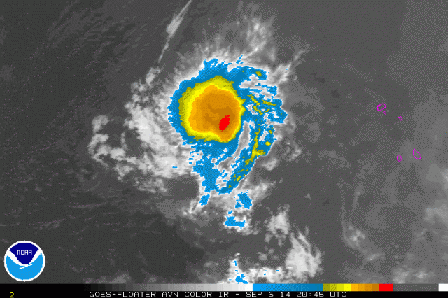
Looks awfully good as a lot of you have said. My personal guess is that conditions are marginal but there is, as Nimbus said, an upper level anticyclone over it which is helping outflow enough to beat the marginal dry air and shear. Also, unless I'm mistaken, the shear forecasts from GFS and ECMWF show the shear dropping over the next couple of days. I love CIMSS but don't always buy their shear tendency chart. as far as dry air goes, it appears that the SAL and dry air are mitigating and there's some very high RH air getting pulled in from the southeast. Regardless, this certainly looks like a TD as Alyono and some others of you have said. Finally, if you look at the water vapor loop you will see this is not going to recurve for the next few days. It's just adjusting its center north and south as it consolidates.

Just goes to show us that the models and we forecasters still don't know a lot about how intensity works.

Image

Image
0 likes   

ozonepete
Professional-Met
Professional-Met
Posts: 4743
Joined: Mon Sep 07, 2009 3:23 pm
Location: From Ozone Park, NYC / Now in Brooklyn, NY

Re: ATL: INVEST 90L - Discussion

#145 Postby ozonepete » Sat Sep 06, 2014 5:09 pm

LaBreeze wrote:
sunnyday wrote:Isn't this one likely to go the way of the others this season? If not, please explain.
Thank you....


I'm thinking like sunnyday - is this expected to be an East Coast scare or a fish?


Way way way too early to know.
0 likes   

User avatar
gatorcane
S2K Supporter
S2K Supporter
Posts: 23499
Age: 46
Joined: Sun Mar 13, 2005 3:54 pm
Location: Boca Raton, FL

#146 Postby gatorcane » Sat Sep 06, 2014 5:13 pm

Latest loop where the banding out nice outflow is evident. I think there may be some kind of center on the SE side of the blob where the deep convection has been maintaining. Hammy I think it is more NW of where your image is showing.


http://rammb.cira.colostate.edu/ramsdis ... display=12
0 likes   

User avatar
TropicalAnalystwx13
Category 5
Category 5
Posts: 2109
Age: 26
Joined: Tue Jul 19, 2011 8:20 pm
Location: Wilmington, NC
Contact:

#147 Postby TropicalAnalystwx13 » Sat Sep 06, 2014 5:24 pm

Looks great convectively speaking, but I see no evidence of a closed wind circulation.
0 likes   

User avatar
Hammy
Category 5
Category 5
Posts: 5594
Age: 40
Joined: Fri May 25, 2012 5:25 pm
Contact:

Re:

#148 Postby Hammy » Sat Sep 06, 2014 5:38 pm

TropicalAnalystwx13 wrote:Looks great convectively speaking, but I see no evidence of a closed wind circulation.


It's certainly closed (albeit weak to the south) at cloud level; I'd give it 50/50 chance that it's closed at the surface. ASCAT will give a better idea in a few hours (if it doesn't miss it)
0 likes   
The above post is not official and should not be used as such. It is the opinion of the poster and may or may not be backed by sound meteorological data. It is not endorsed by any professional institution or storm2k.org. For official information, please refer to the NHC and NWS products.

ozonepete
Professional-Met
Professional-Met
Posts: 4743
Joined: Mon Sep 07, 2009 3:23 pm
Location: From Ozone Park, NYC / Now in Brooklyn, NY

Re: Re:

#149 Postby ozonepete » Sat Sep 06, 2014 5:53 pm

Hammy wrote:
TropicalAnalystwx13 wrote:Looks great convectively speaking, but I see no evidence of a closed wind circulation.


It's certainly closed (albeit weak to the south) at cloud level; I'd give it 50/50 chance that it's closed at the surface. ASCAT will give a better idea in a few hours (if it doesn't miss it)

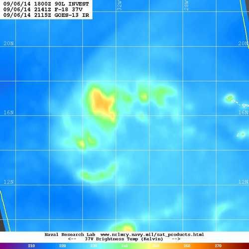
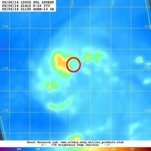
There's no way to tell if there's a closed circulation under that CDO without an ASCAT pass or possibly a 37GHz microwave which shows lower level circulation. And there was a 37GHz pass not long ago at 2141 UTC. I'm showing it here with a circle around where the center looks to be forming. I'm showing it again without the circle so you can see what we're looking at. From that microwave sat it appears to be closed off except for the southeast portion. The ASCAT pass will be very interesting and will tell us a lot.

Image

Image
0 likes   

User avatar
Hammy
Category 5
Category 5
Posts: 5594
Age: 40
Joined: Fri May 25, 2012 5:25 pm
Contact:

#150 Postby Hammy » Sat Sep 06, 2014 6:45 pm

Convection on the decline, is it D-min at the moment or is it a sign it's falling victim to the sinking air?
0 likes   
The above post is not official and should not be used as such. It is the opinion of the poster and may or may not be backed by sound meteorological data. It is not endorsed by any professional institution or storm2k.org. For official information, please refer to the NHC and NWS products.

User avatar
Siker
Category 4
Category 4
Posts: 904
Age: 27
Joined: Thu Oct 25, 2012 7:36 pm
Location: Miami, FL

Re:

#151 Postby Siker » Sat Sep 06, 2014 6:48 pm

Hammy wrote:Convection on the decline, is it D-min at the moment or is it a sign it's falling victim to the sinking air?


Well, D-min did just pass recently, but it could also be a sign of a decline.
0 likes   

User avatar
cycloneye
Admin
Admin
Posts: 139083
Age: 67
Joined: Thu Oct 10, 2002 10:54 am
Location: San Juan, Puerto Rico

Re: ATL: INVEST 90L - Discussion

#152 Postby cycloneye » Sat Sep 06, 2014 6:55 pm

Shower activity has changed little in association with an area of
low pressure located several hundred miles west of the Cape Verde
Islands. This system is moving into an unfavorable environment
during the next several days, and development is not anticipated.
* Formation chance through 48 hours...low...10 percent.
* Formation chance through 5 days...low...10 percent.
0 likes   
Visit the Caribbean-Central America Weather Thread where you can find at first post web cams,radars
and observations from Caribbean basin members Click Here

ozonepete
Professional-Met
Professional-Met
Posts: 4743
Joined: Mon Sep 07, 2009 3:23 pm
Location: From Ozone Park, NYC / Now in Brooklyn, NY

Re:

#153 Postby ozonepete » Sat Sep 06, 2014 6:56 pm

Hammy wrote:Convection on the decline, is it D-min at the moment or is it a sign it's falling victim to the sinking air?


Hi Hammy. :) Where do you see convection declining? I don't see that at all. Do you have images that show that?
0 likes   

User avatar
Nimbus
Category 5
Category 5
Posts: 4928
Joined: Mon Jul 19, 2004 10:54 am

#154 Postby Nimbus » Sat Sep 06, 2014 7:17 pm

If the center of circulation was near those hot towers you saw at sunset then maybe there will still be some CDO tomorrow morning.

I've got to go down and check on the environment around the next wave to see if the the Sahara dust layer is going to shear into it from the north..
0 likes   

User avatar
Hammy
Category 5
Category 5
Posts: 5594
Age: 40
Joined: Fri May 25, 2012 5:25 pm
Contact:

Re: Re:

#155 Postby Hammy » Sat Sep 06, 2014 7:20 pm

ozonepete wrote:
Hammy wrote:Convection on the decline, is it D-min at the moment or is it a sign it's falling victim to the sinking air?


Hi Hammy. :) Where do you see convection declining? I don't see that at all. Do you have images that show that?


RAMMB floater http://tinyurl.com/qbhm7da
And presumably why it was kept at 10%.
0 likes   
The above post is not official and should not be used as such. It is the opinion of the poster and may or may not be backed by sound meteorological data. It is not endorsed by any professional institution or storm2k.org. For official information, please refer to the NHC and NWS products.

ozonepete
Professional-Met
Professional-Met
Posts: 4743
Joined: Mon Sep 07, 2009 3:23 pm
Location: From Ozone Park, NYC / Now in Brooklyn, NY

Re:

#156 Postby ozonepete » Sat Sep 06, 2014 7:21 pm

Nimbus wrote:If the center of circulation was near those hot towers you saw at sunset then maybe there will still be some CDO tomorrow morning.

I've got to go down and check on the environment around the next wave to see if the the Sahara dust layer is going to shear into it from the north..


Well D-MAX is coming so we will see. Don't forget to post anything about the next wave in a new thread.
0 likes   

ozonepete
Professional-Met
Professional-Met
Posts: 4743
Joined: Mon Sep 07, 2009 3:23 pm
Location: From Ozone Park, NYC / Now in Brooklyn, NY

Re: Re:

#157 Postby ozonepete » Sat Sep 06, 2014 7:26 pm

Hammy wrote:
ozonepete wrote:
Hammy wrote:Convection on the decline, is it D-min at the moment or is it a sign it's falling victim to the sinking air?


Hi Hammy. :) Where do you see convection declining? I don't see that at all. Do you have images that show that?


RAMMB floater http://tinyurl.com/qbhm7da
And presumably why it was kept at 10%.


That's more a decrease in intensity of convection. Coverage hasn't changed much. Overall it's not yet significant. Although it is at D-MIN so that would explain those changes. Also that wouldn't be why they kept it at 10%. They are purely using the models to keep it there. Although once again I would caution that the models are still terrible at strength forecasting because they are very poor at predicting how far dry air gets entrained into a TC circulation and even worse at forecasting shear ahead of these systems.
0 likes   

User avatar
TropicalAnalystwx13
Category 5
Category 5
Posts: 2109
Age: 26
Joined: Tue Jul 19, 2011 8:20 pm
Location: Wilmington, NC
Contact:

#158 Postby TropicalAnalystwx13 » Sat Sep 06, 2014 7:45 pm

Glorified wave.

Image
0 likes   

User avatar
cycloneye
Admin
Admin
Posts: 139083
Age: 67
Joined: Thu Oct 10, 2002 10:54 am
Location: San Juan, Puerto Rico

Re: ATL: INVEST 90L - Discussion

#159 Postby cycloneye » Sat Sep 06, 2014 7:45 pm

00z Best Track:

AL, 90, 2014090700, , BEST, 0, 155N, 325W, 25, 1010, DB
0 likes   
Visit the Caribbean-Central America Weather Thread where you can find at first post web cams,radars
and observations from Caribbean basin members Click Here

ozonepete
Professional-Met
Professional-Met
Posts: 4743
Joined: Mon Sep 07, 2009 3:23 pm
Location: From Ozone Park, NYC / Now in Brooklyn, NY

Re:

#160 Postby ozonepete » Sat Sep 06, 2014 7:53 pm

TropicalAnalystwx13 wrote:Glorified wave.

Image


Does not look like a wave at all and that ASCAT pass showed nothing definitive at all. We have to wait for better data.
0 likes   


Return to “2014”

Who is online

Users browsing this forum: No registered users and 118 guests