ATL: INVEST 90L - Models

Moderator: S2k Moderators

Message
Author
User avatar
somethingfunny
ChatStaff
ChatStaff
Posts: 3926
Age: 35
Joined: Thu May 31, 2007 10:30 pm
Location: McKinney, Texas

Re:

#21 Postby somethingfunny » Thu Sep 04, 2014 12:35 pm

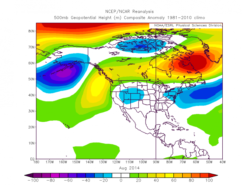
Hurricaneman wrote:Im looking at the models and track wise to the pattern analogs are

Andrew 1992
Betsy 1965
Frances 2004

those stick out like a sore thumb and while I don't know what the intensity will be or track or even if it will develop but the modeled pattern is pretty close to those storms which started a recurve only to have the ridge bridge and fling them west so this will bear watching if the models keep with the pattern that they're showing

The posts in this forum are NOT official forecast and should not be used as such. They are just the opinion of the poster and may or may not be backed by sound meteorological data. They are NOT endorsed by any professional institution or storm2k.org. For official information, please refer to the NHC and NWS products


hey calm down, calm down! ;) the models are picking up on a tropical cyclone in the vicinity of Hispaniola in 8 days, don't worry about Andrew Betsy or Frances yet. The ecmwf isnt even onboard yet
0 likes   
I am not a meteorologist, and any posts made by me are not official forecasts or to be interpreted as being intelligent. These posts are just my opinions and are probably silly opinions.

User avatar
Hurricaneman
Category 5
Category 5
Posts: 7281
Age: 43
Joined: Tue Aug 31, 2004 3:24 pm
Location: central florida

#22 Postby Hurricaneman » Thu Sep 04, 2014 1:00 pm

I was using the track to modeled synoptics not really intensity but thing can change and the possibility is still there for a recurve too we just have to wait and see

The posts in this forum are NOT official forecast and should not be used as such. They are just the opinion of the poster and may or may not be backed by sound meteorological data. They are NOT endorsed by any professional institution or storm2k.org. For official information, please refer to the NHC and NWS products
0 likes   

User avatar
AJC3
Admin
Admin
Posts: 3873
Age: 60
Joined: Tue Aug 31, 2004 7:04 pm
Location: West Melbourne, Florida
Contact:

Re: ATL: INVEST 90L - Models

#23 Postby AJC3 » Thu Sep 04, 2014 1:39 pm

Code: Select all

WHXX01 KWBC 041815
CHGHUR
TROPICAL CYCLONE GUIDANCE MESSAGE
NWS NATIONAL HURRICANE CENTER MIAMI FL
1815 UTC THU SEP 4 2014
 
DISCLAIMER...NUMERICAL MODELS ARE SUBJECT TO LARGE ERRORS.
PLEASE REFER TO NHC OFFICIAL FORECASTS FOR TROPICAL CYCLONE
AND SUBTROPICAL CYCLONE INFORMATION.
 
ATLANTIC OBJECTIVE AIDS FOR
 
DISTURBANCE INVEST (AL902014) 20140904 1800 UTC
 
        ...00 HRS...   ...12 HRS...   ...24 HRS...   ...36 HRS...
        140904  1800   140905  0600   140905  1800   140906  0600
 
         LAT    LON     LAT    LON     LAT    LON     LAT    LON
BAMS    13.2N  20.1W   13.7N  22.7W   14.4N  25.3W   15.2N  27.8W
BAMD    13.2N  20.1W   13.8N  23.0W   14.6N  26.0W   15.5N  28.9W
BAMM    13.2N  20.1W   13.8N  22.7W   14.7N  25.7W   15.7N  28.6W
LBAR    13.2N  20.1W   13.8N  22.9W   14.7N  25.9W   15.6N  28.9W
SHIP        20KTS          26KTS          33KTS          41KTS
DSHP        20KTS          26KTS          33KTS          41KTS
 
        ...48 HRS...   ...72 HRS...   ...96 HRS...   ..120 HRS...
        140906  1800   140907  1800   140908  1800   140909  1800
 
         LAT    LON     LAT    LON     LAT    LON     LAT    LON
BAMS    16.0N  30.7W   17.3N  36.5W   18.9N  42.1W   21.0N  46.8W
BAMD    16.4N  31.8W   18.4N  36.9W   20.5N  40.0W   22.2N  40.6W
BAMM    16.7N  31.6W   18.5N  37.3W   20.3N  41.7W   22.3N  44.1W
LBAR    16.5N  31.8W   18.1N  36.8W   19.5N  40.6W   23.4N  40.7W
SHIP        49KTS          58KTS          60KTS          57KTS
DSHP        49KTS          58KTS          60KTS          57KTS
 
         ...INITIAL CONDITIONS...
LATCUR =  13.2N LONCUR =  20.1W DIRCUR = 280DEG SPDCUR =  12KT
LATM12 =  12.8N LONM12 =  17.7W DIRM12 = 256DEG SPDM12 =  13KT
LATM24 =  14.2N LONM24 =  15.1W
WNDCUR =   20KT RMAXWD =   70NM WNDM12 =   20KT
CENPRS = 1009MB OUTPRS = 1012MB OUTRAD =  200NM SDEPTH =   S
RD34NE =    0NM RD34SE =    0NM RD34SW =    0NM RD34NW =   0NM
 
$$
NNNN
0 likes   

User avatar
gatorcane
S2K Supporter
S2K Supporter
Posts: 23499
Age: 46
Joined: Sun Mar 13, 2005 3:54 pm
Location: Boca Raton, FL

#24 Postby gatorcane » Thu Sep 04, 2014 1:50 pm

18Z Guidance:
Image
0 likes   

User avatar
SFLcane
S2K Supporter
S2K Supporter
Posts: 9606
Age: 46
Joined: Sat Jun 05, 2010 1:44 pm
Location: Lake Worth Florida

Re: ATL: INVEST 90L - Models

#25 Postby SFLcane » Thu Sep 04, 2014 1:55 pm

Interesting look to those models...
0 likes   

User avatar
gatorcane
S2K Supporter
S2K Supporter
Posts: 23499
Age: 46
Joined: Sun Mar 13, 2005 3:54 pm
Location: Boca Raton, FL

#26 Postby gatorcane » Thu Sep 04, 2014 1:56 pm

12Z GFS Ensembles guidance:
Image
0 likes   

User avatar
gatorcane
S2K Supporter
S2K Supporter
Posts: 23499
Age: 46
Joined: Sun Mar 13, 2005 3:54 pm
Location: Boca Raton, FL

#27 Postby gatorcane » Thu Sep 04, 2014 2:04 pm

The 12Z ECMWF is similar to its previous runs in that it might briefly develop it in the Eastern Atlantic but then it opens it back up into a wave or weak low pressure area.

The interesting thing to note about this run is that it moves the area NW NE of the Leewards then around 60W bends it back to the west where it ends up in the SE Bahamas in the long-range.

You can see a loop of the full run here:
http://mp1.met.psu.edu/~fxg1/ECMWFTROPA ... floop.html
0 likes   

User avatar
gatorcane
S2K Supporter
S2K Supporter
Posts: 23499
Age: 46
Joined: Sun Mar 13, 2005 3:54 pm
Location: Boca Raton, FL

#28 Postby gatorcane » Thu Sep 04, 2014 2:56 pm

Here is how the FIM-9 12Z run ends at 168 hours with the system heading WNW:
Image
0 likes   

User avatar
meriland23
Category 5
Category 5
Posts: 1239
Age: 36
Joined: Mon Aug 29, 2011 9:29 pm

Re: ATL: INVEST 90L - Models

#29 Postby meriland23 » Thu Sep 04, 2014 6:41 pm

Current look at 90L...looks to be picking up
Image
0 likes   
The posts in this forum are NOT official forecast and should not be used as such. They are just the opinion of the poster and may or may not be backed by sound meteorological data. They are NOT endorsed by any professional institution or storm2k.org. For official information, please refer to the NHC and NWS products.

User avatar
gatorcane
S2K Supporter
S2K Supporter
Posts: 23499
Age: 46
Joined: Sun Mar 13, 2005 3:54 pm
Location: Boca Raton, FL

#30 Postby gatorcane » Thu Sep 04, 2014 8:31 pm

00Z Guidance:
Image
0 likes   

User avatar
gatorcane
S2K Supporter
S2K Supporter
Posts: 23499
Age: 46
Joined: Sun Mar 13, 2005 3:54 pm
Location: Boca Raton, FL

#31 Postby gatorcane » Thu Sep 04, 2014 8:36 pm

18Z GFS Ensembles:
Image
0 likes   

User avatar
TheStormExpert
Category 5
Category 5
Posts: 8487
Age: 30
Joined: Wed Feb 16, 2011 5:38 pm
Location: Palm Beach Gardens, FL

#32 Postby TheStormExpert » Thu Sep 04, 2014 8:52 pm

:uarrow: I smell a fish!
:fishing:
0 likes   
The following post is NOT an official forecast and should not be used as such. It is just the opinion of the poster and may or may not be backed by sound meteorological data. It is NOT endorsed by storm2k.org.

User avatar
gatorcane
S2K Supporter
S2K Supporter
Posts: 23499
Age: 46
Joined: Sun Mar 13, 2005 3:54 pm
Location: Boca Raton, FL

Re:

#33 Postby gatorcane » Thu Sep 04, 2014 8:55 pm

TheStormExpert wrote::uarrow: I smell a fish!
:fishing:


Remember some of those models are 10-day runs. While the 18Z GFS and ensembles did shift to the east in the long-range, it's still so early in the game. Let's just see if 90l actually makes the journey across the hostile MDR first :)
Last edited by gatorcane on Thu Sep 04, 2014 8:57 pm, edited 1 time in total.
0 likes   

User avatar
pgoss11
Category 2
Category 2
Posts: 702
Joined: Tue Sep 02, 2003 3:55 pm

#34 Postby pgoss11 » Thu Sep 04, 2014 8:55 pm

Odds are always higher that storms will fish. We'll just have to see how strong the ridge is and if any shortwaves will be coming through..Timing is everything..
0 likes   

User avatar
gatorcane
S2K Supporter
S2K Supporter
Posts: 23499
Age: 46
Joined: Sun Mar 13, 2005 3:54 pm
Location: Boca Raton, FL

#35 Postby gatorcane » Thu Sep 04, 2014 9:00 pm

18Z FIM, shows a tropical storm NE of the Leewards and here is how the run ends. Some pretty solid heights north of the system (second image)
Image

Image
0 likes   

CrazyC83
Professional-Met
Professional-Met
Posts: 33393
Joined: Tue Mar 07, 2006 11:57 pm
Location: Deep South, for the first time!

#36 Postby CrazyC83 » Thu Sep 04, 2014 9:19 pm

Looking at those heights, it would likely be trapped in low latitudes unless a weakness opens up...
0 likes   

User avatar
gatorcane
S2K Supporter
S2K Supporter
Posts: 23499
Age: 46
Joined: Sun Mar 13, 2005 3:54 pm
Location: Boca Raton, FL

#37 Postby gatorcane » Fri Sep 05, 2014 8:04 am

06Z Guidance:
Image
0 likes   

User avatar
NDG
S2K Supporter
S2K Supporter
Posts: 14933
Joined: Sun Jul 09, 2006 10:14 pm
Location: Orlando, FL

Re: ATL: INVEST 90L - Models

#38 Postby NDG » Fri Sep 05, 2014 8:39 am

The forecasted pattern over the next few days is totally different than the pattern that we saw during August where a persistent weakness found home in the NW Atlantic thus why Cristobal curved out to sea tracking between Bermuda and the Carolinas. Models are forecasting a stronger Bermuda ridge.
So not unless 90L gets curves out to sea by a weakness in the middle of the Atlantic during the next 2-5 days before it would get steered by the Bermuda ridge, it could approach the northern Leeward Islands or just north of it and start pointing to the Bahamas and possible threatening the SE US. That is if it survives the track across the Atlantic and the usual TUTT in the eastern Caribbean.

Image

Forecasted mid level heights by models during the next 7-10 days:


ImageImage
Image

Personal Forecast Disclaimer:
The posts in this forum are NOT official forecast and should not be used as such. They are just the opinion of the poster and may or may not be backed by sound meteorological data. They are NOT endorsed by any professional institution or storm2k.org. For official information, please refer to the NHC and NWS products.
0 likes   

User avatar
gatorcane
S2K Supporter
S2K Supporter
Posts: 23499
Age: 46
Joined: Sun Mar 13, 2005 3:54 pm
Location: Boca Raton, FL

#39 Postby gatorcane » Fri Sep 05, 2014 9:21 am

:uarrow: NDG yeah the setup could be interesting. My take on the overnight long-range guidance is that it has shifted to more of a trough along the Eastern Seaboard of the U.S. when just yesterday it showed quite a strong ridge. I think we are still at least a few days, probably more like 4-5 of knowing what the pattern could look like downstream. The bigger question, as you mentioned, is whether 90l can even survive long enough to pose any potential threats down the road.
0 likes   

User avatar
NDG
S2K Supporter
S2K Supporter
Posts: 14933
Joined: Sun Jul 09, 2006 10:14 pm
Location: Orlando, FL

Re:

#40 Postby NDG » Fri Sep 05, 2014 9:31 am

gatorcane wrote::uarrow: NDG yeah the setup could be interesting. My take on the overnight long-range guidance is that it has shifted to more of a trough along the Eastern Seaboard of the U.S. when just yesterday it showed quite a strong ridge. I think we are still at least a few days, probably more like 4-5 of knowing what the pattern could look like downstream. The bigger question, as you mentioned, is whether 90l can even survive long enough to pose any potential threats down the road.


Is a pretty strong tropical wave so even if it does not develop over the next few days it will be steered more westward by the lower steering and develop down the road near the lesser Antilles so then it could definitely pose a threat to land, IMO.
0 likes   


Return to “2014”

Who is online

Users browsing this forum: No registered users and 126 guests