ATL: EDOUARD - Post-Tropical - Discussion
Moderator: S2k Moderators
-
gatorcane

- S2K Supporter

- Posts: 23499
- Age: 46
- Joined: Sun Mar 13, 2005 3:54 pm
- Location: Boca Raton, FL
As bad as this has looked, taking a last look at this tonight before checking out, I am seeing a lot of "popcorn" convection firing over the past couple of hours - circulation and vorticity still looks good. I still think this will develop into our next named system when all is said and done. There is just too much model support and I can't believe they all are wrong.
0 likes

Good amount of convection forming on the NW band. If the models can be believed, this will be developing right around the midpoint of the month, which coincides with the next Kelvin wave if not the arrival of the MJO in the basin.
0 likes
The above post is not official and should not be used as such. It is the opinion of the poster and may or may not be backed by sound meteorological data. It is not endorsed by any professional institution or storm2k.org. For official information, please refer to the NHC and NWS products.
-
cycloneye

- Admin

- Posts: 139155
- Age: 67
- Joined: Thu Oct 10, 2002 10:54 am
- Location: San Juan, Puerto Rico
Re: ATL: INVEST 91L - Discussion
Up to 70%.
TROPICAL WEATHER OUTLOOK
NWS NATIONAL HURRICANE CENTER MIAMI FL
800 AM EDT TUE SEP 9 2014
For the North Atlantic...Caribbean Sea and the Gulf of Mexico:
A broad area of low pressure located a few hundred miles south of
the Cape Verde Islands continues to produce disorganized showers and
thunderstorms. Environmental conditions are forecast to be
conducive for gradual development of this disturbance during the
next several days while it moves west-northwestward at about 15 mph.
* Formation chance through 48 hours...medium...30 percent.
* Formation chance through 5 days...high...70 percent.
$$
Forecaster Beven
0 likes
Visit the Caribbean-Central America Weather Thread where you can find at first post web cams,radars
and observations from Caribbean basin members Click Here
and observations from Caribbean basin members Click Here
-
meriland23

- Category 5

- Posts: 1239
- Age: 36
- Joined: Mon Aug 29, 2011 9:29 pm
What are the chances that trough changes or doesn't develop as strong..sending this storm closer to the US?
0 likes
The posts in this forum are NOT official forecast and should not be used as such. They are just the opinion of the poster and may or may not be backed by sound meteorological data. They are NOT endorsed by any professional institution or storm2k.org. For official information, please refer to the NHC and NWS products.

-
wxman57

- Moderator-Pro Met

- Posts: 22482
- Age: 66
- Joined: Sat Jun 21, 2003 8:06 pm
- Location: Houston, TX (southwest)
Re: ATL: INVEST 91L - Discussion
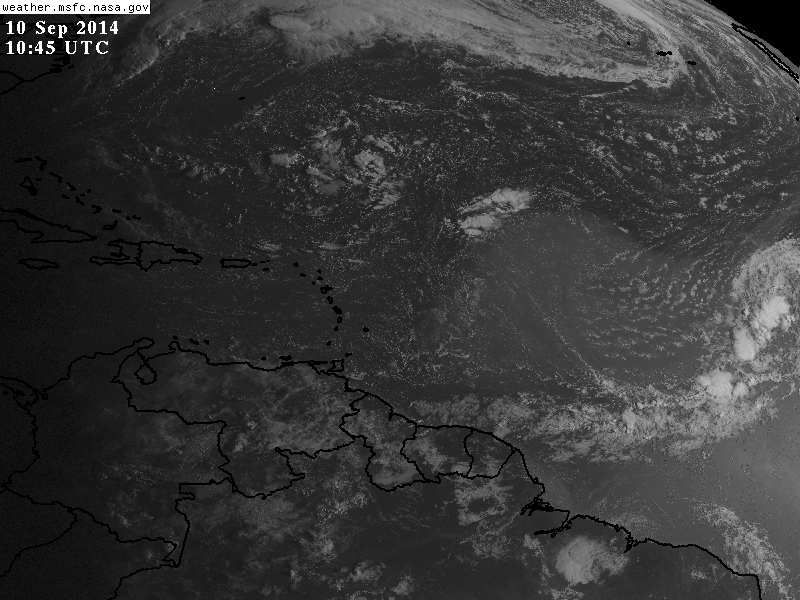
Looking at the latest satellite imagery, I would have decreased development chances rather than bumping them up to 70%. There's nothing at all where the 12Z models were initialized (see image below). No rotation, no convection, nothing. The wave axis is a little east of that point. This disturbance is heading through/into a fairly hostile environment. Plenty of dry, sinking air.
Whether or not it develops, it won't likely impact the Caribbean or the East U.S. Coast. The Bermuda High is way too weak for that now. Cold fronts are starting to push off the US East Coast and into the Gulf of Mexico (later this week). There's nothing to carry it that far west starting at 12-15N.

Whether or not it develops, it won't likely impact the Caribbean or the East U.S. Coast. The Bermuda High is way too weak for that now. Cold fronts are starting to push off the US East Coast and into the Gulf of Mexico (later this week). There's nothing to carry it that far west starting at 12-15N.
0 likes
-
Blown Away

- S2K Supporter
- Posts: 9863
- Joined: Wed May 26, 2004 6:17 am
Re: Re:
Senobia wrote:meriland23 wrote:What are the chances that trough changes or doesn't develop as strong..sending this storm closer to the US?
Yes, ditto what she asked.

NWS thinking 91L recurves before @50W... After 91L, seems a bit late in the season for a CV system to track across the pond and effect land... Might have to start looking in the NW Caribbean...
0 likes
Hurricane Eye Experience: David 79, Irene 99, Frances 04, Jeanne 04, Wilma 05...
Hurricane Brush Experience: Andrew 92, Erin 95, Floyd 99, Matthew 16, Irma 17, Ian 22, Nicole 22…
Hurricane Brush Experience: Andrew 92, Erin 95, Floyd 99, Matthew 16, Irma 17, Ian 22, Nicole 22…
-
wxman57
- Moderator-Pro Met
- Posts: 22482
- Age: 66
- Joined: Sat Jun 21, 2003 8:06 pm
- Location: Houston, TX (southwest)
Re: ATL: INVEST 91L - Discussion
Why won't 91L likely reach the East U.S. Coast? Take a look at the upper-level winds as projected by the GFS valid for next Wednesday. A significant cold front pushes off the East Coast this weekend, with a jet core digging into the Gulf and off the East Coast. 91L would be heading right into very strong upper-level wind flow as it passes 60W. The flow would turn it north and northeast, not west toward the U.S.

0 likes
Re: ATL: INVEST 91L - Discussion
Another toaster if you ask me.
This year shows how systems try to form from tropical conditions with convection and a center swirl but fail to have the moist inflow and vertical instability to complete the process. Capped and starved of fuel. Ghost systems.
The posts in this forum are NOT official forecast and should not be used as such. They are just the opinion of the poster and may or may not be backed by sound meteorological data. They are NOT endorsed by any professional institution or storm2k.org. For official information, please refer to the NHC and NWS products.
0 likes
-
wxman57
- Moderator-Pro Met
- Posts: 22482
- Age: 66
- Joined: Sat Jun 21, 2003 8:06 pm
- Location: Houston, TX (southwest)
Re: ATL: INVEST 91L - Discussion
I wouldn't call it "toast" as far as development chances down the road. Even the Euro is developing this into a strong hurricane by the middle of next week. It's just not going to develop in the next couple of days, and it isn't going to be a U.S. or Caribbean threat.
0 likes
-
WPBWeather

- S2K Supporter
- Posts: 535
- Age: 65
- Joined: Thu Jul 18, 2013 12:33 pm
Re: ATL: INVEST 91L - Discussion
wxman57 wrote:Why won't 91L likely reach the East U.S. Coast? Take a look at the upper-level winds as projected by the GFS valid for next Wednesday. A significant cold front pushes off the East Coast this weekend, with a jet core digging into the Gulf and off the East Coast. 91L would be heading right into very strong upper-level wind flow as it passes 60W. The flow would turn it north and northeast, not west toward the U.S.
http://home.comcast.net/~cgh57/upperwinds.gif
Timing is everything in life and in weather. At least this is one good LEADING indicator (among the many other lagging--SAL, shear, dry air etc. etc. that have been discussed by others so far) of what may happen with this one. Thank you wxman57 for posting it.
0 likes
-
cycloneye
- Admin
- Posts: 139155
- Age: 67
- Joined: Thu Oct 10, 2002 10:54 am
- Location: San Juan, Puerto Rico
Re: ATL: INVEST 91L - Discussion
Shower activity associated with a broad area of low pressure located
a few hundred miles southwest of the Cape Verde Islands has changed
little in organization during the past several hours. Environmental
conditions are forecast to be conducive for gradual development of
this disturbance during the next several days while it moves
west-northwestward at about 15 mph.
* Formation chance through 48 hours...medium...30 percent.
* Formation chance through 5 days...high...70 percent.
0 likes
Visit the Caribbean-Central America Weather Thread where you can find at first post web cams,radars
and observations from Caribbean basin members Click Here
and observations from Caribbean basin members Click Here
-
cycloneye
- Admin
- Posts: 139155
- Age: 67
- Joined: Thu Oct 10, 2002 10:54 am
- Location: San Juan, Puerto Rico
Re: ATL: INVEST 91L - Discussion
18z Best Track:
AL, 91, 2014090918, , BEST, 0, 135N, 280W, 25, 1009, LO
AL, 91, 2014090918, , BEST, 0, 135N, 280W, 25, 1009, LO
0 likes
Visit the Caribbean-Central America Weather Thread where you can find at first post web cams,radars
and observations from Caribbean basin members Click Here
and observations from Caribbean basin members Click Here
-
wxman57
- Moderator-Pro Met
- Posts: 22482
- Age: 66
- Joined: Sat Jun 21, 2003 8:06 pm
- Location: Houston, TX (southwest)
Re: ATL: INVEST 91L - Discussion
12Z Euro gave up on development after forecasting a major hurricane in the 00Z run.
0 likes
Re: ATL: INVEST 91L - Discussion
wxman57 wrote:12Z Euro gave up on development after forecasting a major hurricane in the 00Z run.
Safe to say it's pretty much over at this point as far as development goes?
0 likes
The above post is not official and should not be used as such. It is the opinion of the poster and may or may not be backed by sound meteorological data. It is not endorsed by any professional institution or storm2k.org. For official information, please refer to the NHC and NWS products.
-
wxman57
- Moderator-Pro Met
- Posts: 22482
- Age: 66
- Joined: Sat Jun 21, 2003 8:06 pm
- Location: Houston, TX (southwest)
Re: ATL: INVEST 91L - Discussion
Hammy wrote:wxman57 wrote:12Z Euro gave up on development after forecasting a major hurricane in the 00Z run.
Safe to say it's pretty much over at this point as far as development goes?
Of this disturbance? No. Of the season? No. But all signs point to continued below-normal activity in the basin.
0 likes

Percentage dropped down to 20% for the next 48hrs by the latest NHC TWO, I agree.
TROPICAL WEATHER OUTLOOK
NWS NATIONAL HURRICANE CENTER MIAMI FL
800 PM EDT TUE SEP 9 2014
For the North Atlantic...Caribbean Sea and the Gulf of Mexico:
A broad area of low pressure is located a few hundred miles west of
the Cape Verde Islands. Shower activity associated with this low
has not become any better organized since yesterday, and no
tropical cyclone formation is anticipated tonight or Wednesday.
However, environmental conditions could become a little more
favorable for development by later in the week while the low moves
toward the west-northwest and northwest at about 15 mph over the
open Atlantic.
* Formation chance through 48 hours...low...20 percent.
* Formation chance through 5 days...high...70 percent.
0 likes
-
gatorcane
- S2K Supporter
- Posts: 23499
- Age: 46
- Joined: Sun Mar 13, 2005 3:54 pm
- Location: Boca Raton, FL
Looks more like an elongated trough oriented SW to NE. I am noticing more convection on the SW end of this trough then on the NE side where NHC has the "X." Looking at the 850MB vorticity, looks like it showing an elongated area too with two area of deeper vorticity.
Any chance the SW area is the one that may develop and head more west?


Any chance the SW area is the one that may develop and head more west?
0 likes
-
xtyphooncyclonex

- Category 5
- Posts: 3688
- Age: 22
- Joined: Sat Dec 08, 2012 9:07 am
- Location: Cebu City
- Contact:
The CPC had highlighted too a chance of development from this. IMO, if we see this develop, it would not be anything significant nor powerful (obviously). And if it impacts any part of the CONUS, it is highly unlikely based on steering.
0 likes
REMINDER: My opinions that I, or any other NON Pro-Met in this forum, are unofficial. Please do not take my opinions as an official forecast and warning. I am NOT a meteorologist. Following my forecasts blindly may lead to false alarm, danger and risk if official forecasts from agencies are ignored.
Who is online
Users browsing this forum: No registered users and 52 guests