ATL: EDOUARD - Models

Moderator: S2k Moderators

Message
Author
User avatar
Hammy
Category 5
Category 5
Posts: 5594
Age: 40
Joined: Fri May 25, 2012 5:25 pm
Contact:

Re: Re:

#41 Postby Hammy » Sun Sep 07, 2014 6:08 pm

LarryWx wrote:Keep in mind that, overall, something forming well east out in the MDR in Sep. only has ~20% chance of hitting the CONUS. The current chance is a good bit lower than the already rather low climo of 20%.


Isn't the 15th pretty much the averaged point anyway where storms that form that far east generally go out to sea?
0 likes   
The above post is not official and should not be used as such. It is the opinion of the poster and may or may not be backed by sound meteorological data. It is not endorsed by any professional institution or storm2k.org. For official information, please refer to the NHC and NWS products.

Alyono
Professional-Met
Professional-Met
Posts: 6961
Joined: Fri Apr 26, 2013 3:52 pm
Location: Texas Coast

Re: Re:

#42 Postby Alyono » Sun Sep 07, 2014 6:39 pm

Hammy wrote:
LarryWx wrote:Keep in mind that, overall, something forming well east out in the MDR in Sep. only has ~20% chance of hitting the CONUS. The current chance is a good bit lower than the already rather low climo of 20%.


Isn't the 15th pretty much the averaged point anyway where storms that form that far east generally go out to sea?


Georges formed on Sept 15 and it did make it the entire way across

I have seen storms make it across late. They typically remain around 10N until 45 or 50W
0 likes   

LarryWx
Category 5
Category 5
Posts: 5702
Joined: Sun Sep 07, 2003 2:04 pm
Location: GA

Re: Re:

#43 Postby LarryWx » Sun Sep 07, 2014 7:38 pm

Hammy wrote:
LarryWx wrote:Keep in mind that, overall, something forming well east out in the MDR in Sep. only has ~20% chance of hitting the CONUS. The current chance is a good bit lower than the already rather low climo of 20%.


Isn't the 15th pretty much the averaged point anyway where storms that form that far east generally go out to sea?


I calculated that ~1 in 7 of the 9/15 or later CV formations later hit the CONUS. For Sep as a whole, I calculated it to be ~1 in 5. So, for 9/1-14 formations, alone, I'm guessing it might actually be closer to ~1 in 4 hitting the CONUS. OTOH, for El Nino/oncoming El Nino seasons, alone, the chance of a 9/1-14 formation hitting is probably no higher than ~1 in 5 and may even be more like only 1 in 6.

Exact dates of FORMATION (TD+) for the 47 1851-2013 CV storms* that later hit the CONUS including Earl of 2010 and Emily of 2005:

7/5, 7/11, 7/15, 7/31, 8/3, 8/3, 8/5, 8/7, 8/7, 8/15, 8/15, 8/16, 8/16, 8/17, 8/17, 8/18, 8/19, 8/20, 8/20, 8/21,8/23, 8/23, 8/25, 8/25, 8/27, 8/28, 8/28, 8/29, 8/29, 9/1, 9/2, 9/3, 9/4, 9/6, 9/6, 9/7, 9/8, 9/10, 9/10, 9/10, 9/10, 9/11, 9/15, 9/16, 9/21, 9/21, 9/25

*My def. of CV storm: tropical storm/hurricane that first became at least a TD E of 50W and S of 20N

So, 163 years of history clearly show a sharp peak on 9/10 for storms that form E of 50W and later hit the CONUS, but then frequency drops sharply. Regarding 9/15+ CV formations that later hit the CONUS (~1 in 7 of these formations hit):
1) Lili of 2002 formed on 9/21 and did what I think 91-L would have to do to threaten the CONUS, go through the Caribbean. That was during El Nino.
2) As mentioned by Alyono, Georges of 1998 formed on 9/15 and later came all of the way across to the Gulf coast.
3) Gloria of 1985 formed on 9/16 and hit from NC to the NE US.
4) Inez of 1966 formed on 9/21 and later hit far S FL/Keys.
5) In 1893, a storm formed on 9/25 and it came all of the way across to slam the Carolinas on 10/13!
Last edited by LarryWx on Mon Sep 08, 2014 8:27 am, edited 1 time in total.
0 likes   
Personal Forecast Disclaimer:
The posts in this forum are NOT official forecasts and should not be used as such. They are just the opinion of the poster and may or may not be backed by sound meteorological data. They are NOT endorsed by any professional institution or storm2k.org. For official information, please refer to the NHC and NWS products.

YoshiMike
Tropical Storm
Tropical Storm
Posts: 106
Age: 28
Joined: Wed Aug 27, 2014 9:18 pm
Location: Hattiesburg, MS
Contact:

Re: ATL: INVEST 91L - Models

#44 Postby YoshiMike » Sun Sep 07, 2014 8:31 pm

what is CONUS
0 likes   
Okay guys, just because I want to BE a meteorologist, want to go to school for meteorology, DOES NOT MAKE ME A METEOROLOGIST. Anything I say about tropical weather is either me learning something new, or is just an opinion and nothing more than that. I can almost guarantee you that I will be wrong about pretty much everything.

User avatar
StormingB81
S2K Supporter
S2K Supporter
Posts: 5676
Age: 42
Joined: Thu Aug 27, 2009 1:45 am
Location: Rockledge, Florida

Re: ATL: INVEST 91L - Models

#45 Postby StormingB81 » Sun Sep 07, 2014 8:33 pm

YoshiMike wrote:what is CONUS


Continental United States
0 likes   

YoshiMike
Tropical Storm
Tropical Storm
Posts: 106
Age: 28
Joined: Wed Aug 27, 2014 9:18 pm
Location: Hattiesburg, MS
Contact:

Re: ATL: INVEST 91L - Models

#46 Postby YoshiMike » Sun Sep 07, 2014 8:39 pm

Thank you, Very much
0 likes   
Okay guys, just because I want to BE a meteorologist, want to go to school for meteorology, DOES NOT MAKE ME A METEOROLOGIST. Anything I say about tropical weather is either me learning something new, or is just an opinion and nothing more than that. I can almost guarantee you that I will be wrong about pretty much everything.

User avatar
SFLcane
S2K Supporter
S2K Supporter
Posts: 9606
Age: 46
Joined: Sat Jun 05, 2010 1:44 pm
Location: Lake Worth Florida

Re: ATL: INVEST 91L - Models

#47 Postby SFLcane » Sun Sep 07, 2014 9:31 pm

Up and out per emsembles this evening..

Image
Last edited by SFLcane on Sun Sep 07, 2014 9:31 pm, edited 1 time in total.
0 likes   

User avatar
Hurricaneman
Category 5
Category 5
Posts: 7281
Age: 43
Joined: Tue Aug 31, 2004 3:24 pm
Location: central florida

#48 Postby Hurricaneman » Sun Sep 07, 2014 11:13 pm

The 0zGFS is quite a bit farther south of the 18z132hr position at 126hrs

The posts in this forum are NOT official forecast and should not be used as such. They are just the opinion of the poster and may or may not be backed by sound meteorological data. They are NOT endorsed by any professional institution or storm2k.org. For official information, please refer to the NHC and NWS products
0 likes   

Alyono
Professional-Met
Professional-Met
Posts: 6961
Joined: Fri Apr 26, 2013 3:52 pm
Location: Texas Coast

#49 Postby Alyono » Sun Sep 07, 2014 11:44 pm

the 0Z GFS appears EAST of the 18Z

too much troughing to get this close to land
0 likes   

User avatar
Blown Away
S2K Supporter
S2K Supporter
Posts: 9862
Joined: Wed May 26, 2004 6:17 am

Re: ATL: INVEST 91L - Models

#50 Postby Blown Away » Mon Sep 08, 2014 6:39 am

Image

Image
06z...

Image
06z...
0 likes   
Hurricane Eye Experience: David 79, Irene 99, Frances 04, Jeanne 04, Wilma 05...
Hurricane Brush Experience: Andrew 92, Erin 95, Floyd 99, Matthew 16, Irma 17, Ian 22, Nicole 22…

tolakram
Admin
Admin
Posts: 19165
Age: 60
Joined: Sun Aug 27, 2006 8:23 pm
Location: Florence, KY (name is Mark)

Re: ATL: INVEST 91L - Models

#51 Postby tolakram » Mon Sep 08, 2014 6:43 am

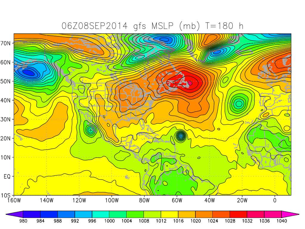
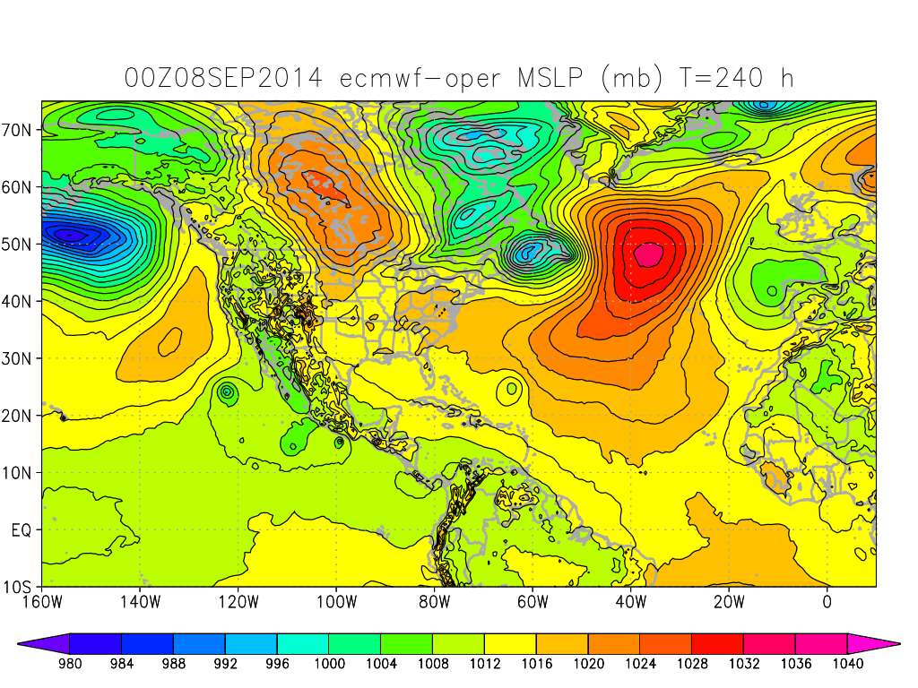
GFS and Euro hanging on to 91L.

6Z GFS
Image

0Z Euro
Image
0 likes   
M a r k
- - - - -
Join us in chat: Storm2K Chatroom Invite. Android and IOS apps also available.

The posts in this forum are NOT official forecasts and should not be used as such. Posts are NOT endorsed by any professional institution or STORM2K.org. For official information and forecasts, please refer to NHC and NWS products.

tolakram
Admin
Admin
Posts: 19165
Age: 60
Joined: Sun Aug 27, 2006 8:23 pm
Location: Florence, KY (name is Mark)

Re: ATL: INVEST 91L - Models

#52 Postby tolakram » Mon Sep 08, 2014 6:45 am

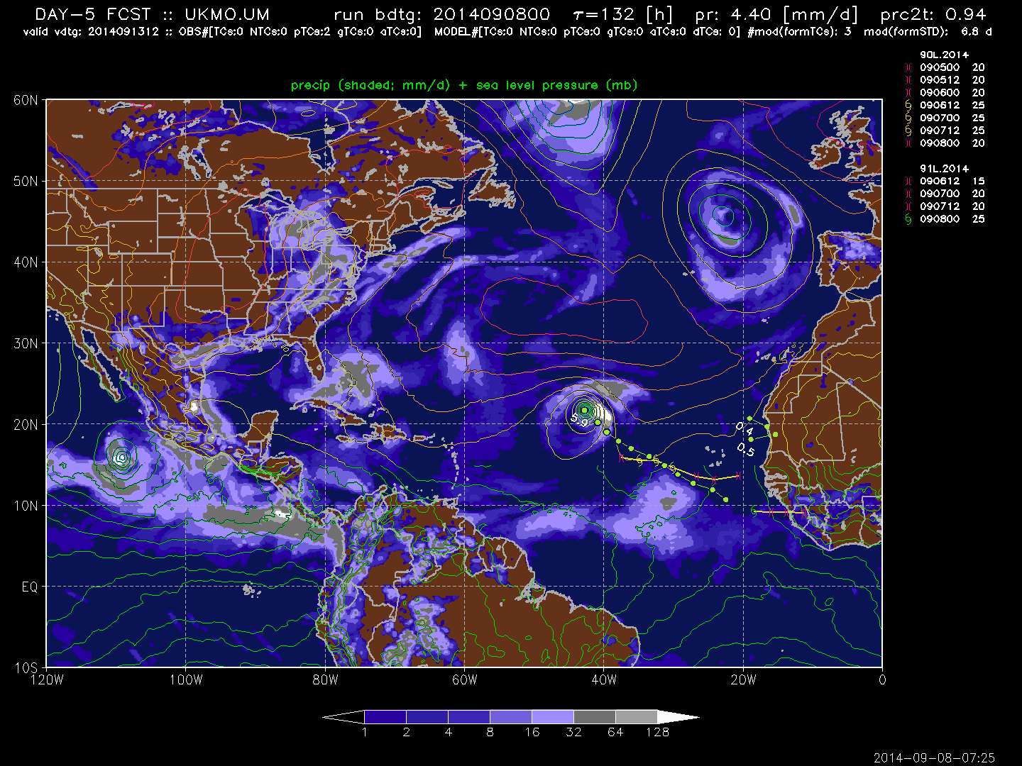
UKMet has it as well, further north.

Image

sources for above images:

GFS & Euro: http://moe.met.fsu.edu/tcgengifs/

UKMet: http://ruc.noaa.gov/hfip/tcgen/
0 likes   
M a r k
- - - - -
Join us in chat: Storm2K Chatroom Invite. Android and IOS apps also available.

The posts in this forum are NOT official forecasts and should not be used as such. Posts are NOT endorsed by any professional institution or STORM2K.org. For official information and forecasts, please refer to NHC and NWS products.

User avatar
gatorcane
S2K Supporter
S2K Supporter
Posts: 23499
Age: 46
Joined: Sun Mar 13, 2005 3:54 pm
Location: Boca Raton, FL

#53 Postby gatorcane » Mon Sep 08, 2014 12:42 pm

GEM now develops this.
0 likes   

User avatar
TheStormExpert
Category 5
Category 5
Posts: 8487
Age: 30
Joined: Wed Feb 16, 2011 5:38 pm
Location: Palm Beach Gardens, FL

Re:

#54 Postby TheStormExpert » Mon Sep 08, 2014 12:43 pm

gatorcane wrote:GEM now develops this.

Hallelujah! There may still be hope. :lol:
0 likes   
The following post is NOT an official forecast and should not be used as such. It is just the opinion of the poster and may or may not be backed by sound meteorological data. It is NOT endorsed by storm2k.org.

User avatar
Blown Away
S2K Supporter
S2K Supporter
Posts: 9862
Joined: Wed May 26, 2004 6:17 am

Re: ATL: INVEST 91L - Models

#55 Postby Blown Away » Mon Sep 08, 2014 12:51 pm

Image
12z...

Image
12z...

Image
0 likes   
Hurricane Eye Experience: David 79, Irene 99, Frances 04, Jeanne 04, Wilma 05...
Hurricane Brush Experience: Andrew 92, Erin 95, Floyd 99, Matthew 16, Irma 17, Ian 22, Nicole 22…

User avatar
Riptide
Category 2
Category 2
Posts: 753
Age: 32
Joined: Fri Jul 23, 2010 3:33 pm
Location: Cape May, New Jersey
Contact:

Re: ATL: INVEST 91L - Models

#56 Postby Riptide » Mon Sep 08, 2014 1:09 pm

12z Euro coming in more organized, all systems go. Probably still a bit conservative.
http://www.instantweathermaps.com/ECMWF ... sl_072.gif
:wink:
0 likes   

User avatar
TropicalAnalystwx13
Category 5
Category 5
Posts: 2109
Age: 26
Joined: Tue Jul 19, 2011 8:20 pm
Location: Wilmington, NC
Contact:

#57 Postby TropicalAnalystwx13 » Mon Sep 08, 2014 1:48 pm

The 12z ECMWF really likes Invest 91L; it's down to 977 millibars in 180 hours.
0 likes   

tolakram
Admin
Admin
Posts: 19165
Age: 60
Joined: Sun Aug 27, 2006 8:23 pm
Location: Florence, KY (name is Mark)

Re: ATL: INVEST 91L - Models

#58 Postby tolakram » Mon Sep 08, 2014 1:55 pm

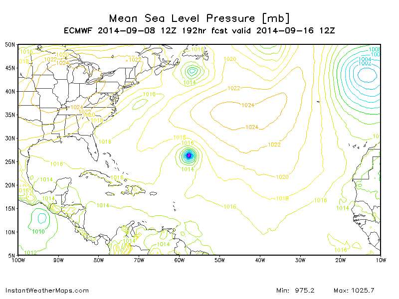
12Z Euro 192 hours, a big flip from the last run.

Image
0 likes   
M a r k
- - - - -
Join us in chat: Storm2K Chatroom Invite. Android and IOS apps also available.

The posts in this forum are NOT official forecasts and should not be used as such. Posts are NOT endorsed by any professional institution or STORM2K.org. For official information and forecasts, please refer to NHC and NWS products.

tolakram
Admin
Admin
Posts: 19165
Age: 60
Joined: Sun Aug 27, 2006 8:23 pm
Location: Florence, KY (name is Mark)

Re: ATL: INVEST 91L - Models

#59 Postby tolakram » Mon Sep 08, 2014 1:58 pm

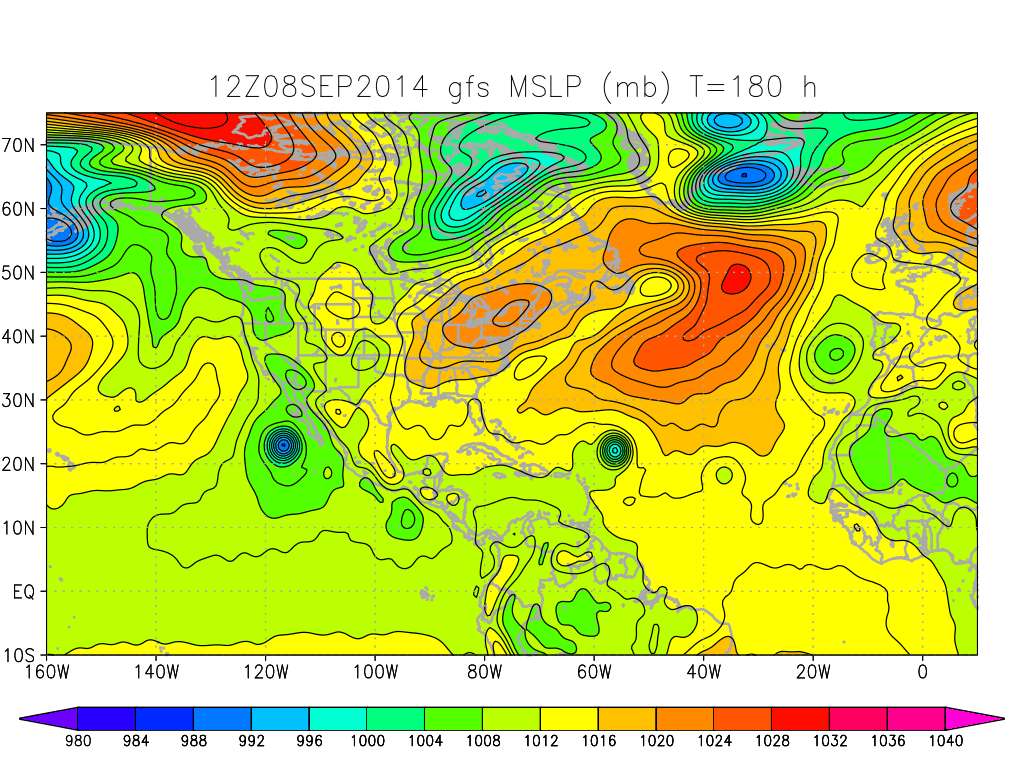
12Z GFS continues slow and steady development through 180 hours.

Image
0 likes   
M a r k
- - - - -
Join us in chat: Storm2K Chatroom Invite. Android and IOS apps also available.

The posts in this forum are NOT official forecasts and should not be used as such. Posts are NOT endorsed by any professional institution or STORM2K.org. For official information and forecasts, please refer to NHC and NWS products.

User avatar
gatorcane
S2K Supporter
S2K Supporter
Posts: 23499
Age: 46
Joined: Sun Mar 13, 2005 3:54 pm
Location: Boca Raton, FL

#60 Postby gatorcane » Mon Sep 08, 2014 2:16 pm

12Z Euro and GFS like this to eventually become what looks like a significant hurricane out in the middle of nowhere impacting nobody. Could be a big ACE pumper!
0 likes   


Return to “2014”

Who is online

Users browsing this forum: No registered users and 111 guests