

ATL: INVEST 92L - Models
Moderator: S2k Moderators
Re: ATL: INVEST 92L - Models
This image is from the Gulf Coast Weather/Gulf Coast Spotters page. It was accompanied by a big long spiel about how this system is a non-issue, won't develop - blah blah. If that's the case, what are all these models seeing to track?
0 likes

Re: ATL: INVEST 92L - Models
Senobia wrote:This image is from the Gulf Coast Weather/Gulf Coast Spotters page. It was accompanied by a big long spiel about how this system is a non-issue, won't develop - blah blah. If that's the case, what are all these models seeing to track?
Exactly - but I would expect these plots to probably change.
0 likes
Audrey (1957), Carla (1961), Hilda (1964), Betsy (1965), Edith (1971), Carmen (1974), Danny (1985), Juan (1985), Andrew (1992), Lili (2002), Rita (2005), Gustav (2008), Ike (2008), and stuck in the eye of Iniki (1992) while vacationing in Kauai.
Not an official forecast by any means.
Not an official forecast by any means.


Re: ATL: INVEST 92L - Models
Looking at the local radar the area of light rain is shrinking and seems to be moving west, with a twist in the echos now west of GBI, but as the NHC said northerly shear is affecting the weak low...
0 likes
-
skysummit

- S2K Supporter

- Posts: 5305
- Age: 48
- Joined: Tue Aug 31, 2004 11:09 pm
- Location: Ponchatoula, LA
- Contact:
Re: ATL: INVEST 92L - Models
Senobia wrote:This image is from the Gulf Coast Weather/Gulf Coast Spotters page. It was accompanied by a big long spiel about how this system is a non-issue, won't develop - blah blah. If that's the case, what are all these models seeing to track?
"Big long spiel"???? I made the post on GCWX and was notified that it was on here so I figured I'd chime in. It's my image. Here's the post:
http://forums.gulfcoastwx.com/post/128305/thread
No where does it have a "big long spiel about how this system is a non-issue". The discussion is how upper levels are not supportive of anything threatening.
0 likes
Re: ATL: INVEST 92L - Models
skysummit wrote:Senobia wrote:This image is from the Gulf Coast Weather/Gulf Coast Spotters page. It was accompanied by a big long spiel about how this system is a non-issue, won't develop - blah blah. If that's the case, what are all these models seeing to track?
"Big long spiel"???? I made the post on GCWX and was notified that it was on here so I figured I'd chime in. It's my image. Here's the post:
http://forums.gulfcoastwx.com/post/128305/thread
No where does it have a "big long spiel about how this system is a non-issue". The discussion is how upper levels are not supportive of anything threatening.
Actually, no - here....is the post that *I* was referencing:
https://www.facebook.com/photo.php?fbid=731789350192293
early afternoon guidance on 92L. Thankfully upper level winds are expected to remain unfavorable for the life of 92L. If it were to come together in the gulf, we'd be looking at a TD or weak TS at most, but even that is pretty unlikely as of now.
From your Facebook page, via your Twitter.
Now that you're here, I'll ask you the question I posed earlier. If this system is really a non-issue, what are the models seeing in your graphic?
0 likes
-
skysummit
- S2K Supporter
- Posts: 5305
- Age: 48
- Joined: Tue Aug 31, 2004 11:09 pm
- Location: Ponchatoula, LA
- Contact:
Ahhh...gotcha.
Yes, when that post was made, upper level conditions were forecasted to be highly unfavorable in the gulf, however latest upper level forecasts have somewhat changed, and are now indicating conditions may not be all that bad in the gulf (especially the ECMWF). So while this still should not be a highly threatening system, chances are increasing that this may eventually reach TS status in the gulf, and possibly a moderate to strong one given the latest data. (one model even forecasts a hurricane in 5 days, but big grains of salt are taken with it)
It could be an interesting weekend of watching for gulf coast residents.
0 likes

Re: ATL: INVEST 92L - Models
FWIW (probably not much) the Canadian stays consistent with a westward moving storm that comes to the doorstep of LA, then turns due east and rides the coastline:
CMC 00Z +24

CMC 00Z +24
0 likes


Re: ATL: INVEST 92L - Models
N2FSU wrote:Some 12Z runs
Again, what's with the retreat? It gets all the way to Texas, meets the cold front (that may nor may not be happening) and decides, "Ooops, wrong way, lemme turn around"?
0 likes
Re:
skysummit wrote:Ahhh...gotcha.
Yes, when that post was made, upper level conditions were forecasted to be highly unfavorable in the gulf, however latest upper level forecasts have somewhat changed, and are now indicating conditions may not be all that bad in the gulf (especially the ECMWF). So while this still should not be a highly threatening system, chances are increasing that this may eventually reach TS status in the gulf, and possibly a moderate to strong one given the latest data. (one model even forecasts a hurricane in 5 days, but big grains of salt are taken with it)
It could be an interesting weekend of watching for gulf coast residents.
Okay. Thanks.
0 likes
-
tolakram
- Admin

- Posts: 19165
- Age: 60
- Joined: Sun Aug 27, 2006 8:23 pm
- Location: Florence, KY (name is Mark)
Re: ATL: INVEST 92L - Models
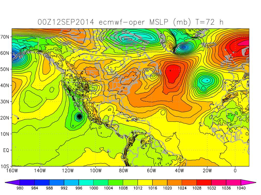
The 0Z euro did show a small low at 72 hours.
0 likes
M a r k
- - - - -
Join us in chat: Storm2K Chatroom Invite. Android and IOS apps also available.
The posts in this forum are NOT official forecasts and should not be used as such. Posts are NOT endorsed by any professional institution or STORM2K.org. For official information and forecasts, please refer to NHC and NWS products.
-
CYCLONE MIKE
- Category 5

- Posts: 2183
- Joined: Tue Aug 31, 2004 6:04 pm
- Location: Gonzales, LA
Re: ATL: INVEST 92L - Models
N2FSU wrote:Some 12Z runs
Time to start boarding up and gassing up vehicles and generators.
0 likes

Re: ATL: INVEST 92L - Models
I was kind of hoping 92L would stay shallow enough that it would come back to Florida and give us some rain for the winter wells.
Mexico doesn't need a cat 3.
Mexico doesn't need a cat 3.
0 likes
Who is online
Users browsing this forum: No registered users and 52 guests