ATL: GONZALO - Post-Tropical - Discussion
Moderator: S2k Moderators
- Gustywind
- Category 5

- Posts: 12334
- Joined: Mon Sep 03, 2007 7:29 am
- Location: Baie-Mahault, GUADELOUPE
Mention as a special feature ...
TROPICAL WEATHER DISCUSSION
NWS NATIONAL HURRICANE CENTER MIAMI FL
805 PM EDT SAT OCT 11 2014
A TROPICAL WAVE WITH AN EMBEDDED 1009 MB LOW IS AT AROUND 350 NM
E OF THE LESSER ANTILLES WITH AXIS EXTENDING FROM 20N55W TO
13N54W...MOVING W AT 10-15 KT. ABUNDANT MOISTURE IS IN THE
ENVIRONMENT OF THESE WAVE/LOW AS DEPICTED ON SSMI TOTAL
PRECIPITABLE WATER IMAGERY. DESPITE THIS...ONLY SCATTERED
MODERATE CONVECTION PREVAILS BEHIND THE WAVE AXIS FROM 13N-16N
BETWEEN 54W-55W. THE LOW IS EXPECTED TO MOVE W AFFECTING THE
LEEWARD ISLAND...PUERTO RICO...HISPANIOLA AND THE SOUTHEASTERN
BAHAMAS. THE CHANCE FOR FORMATION THROUGH THE NEXT 48 HOURS OF
THIS SYSTEM IS MEDIUM.
0 likes
-
ozonepete
- Professional-Met

- Posts: 4743
- Joined: Mon Sep 07, 2009 3:23 pm
- Location: From Ozone Park, NYC / Now in Brooklyn, NY
Re:
Hammy wrote:I'll give it <10% chance at this point, the Euro tracks it over the main islands, and the only models that develop this now are the ones that develop every thunderstorm into a hurricane. And there is a good amount of dry air just to the northeast that is moving faster SW than the system itself.
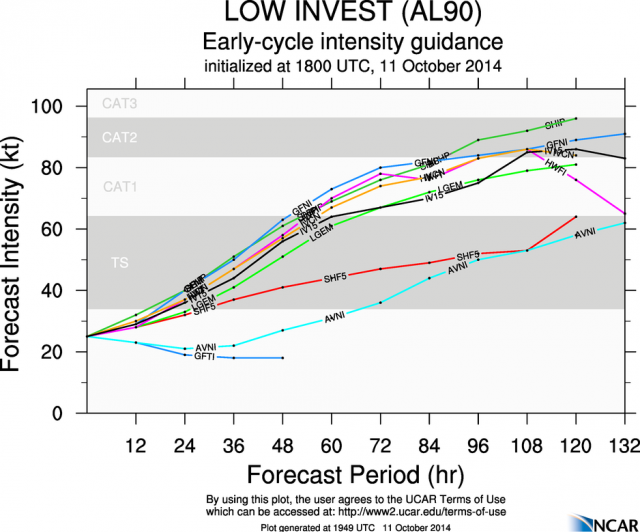
Hi Hammy! Are you still sticking to that prediction? Here's a look at the UCAR listing of a number of latest model intensity forecasts from 18Z today. I'd hardly say the majority don't develop it or that those models always develop every thunderstorm into a cat 5, lol.
Also, the dry air to its north is not outrunning it or moving southward at all. It is the dry air in front of the track of a TC that matters if the TC is not moving slowly. In this case there may be some dry air problems in the short term but it will soon be in a much more moist environment on all sides. You should also note that there are no arc clouds coming out of the thunderstorms on the north side. IF those thunderstorms were ingesting dry air at mid-levels they'd be collapsing and shooting out those classic arc clouds. So far that's not happening, but if we see them overnight or tomorrow then I would say the dry air was getting ingested. Until then I wouldn't.
If I lived in those northern islands I'd be watching this really carefully.

0 likes
-
TARHEELPROGRAMMER
Re:
Gustywind wrote::darrow:
Mention as a special feature ...
TROPICAL WEATHER DISCUSSION
NWS NATIONAL HURRICANE CENTER MIAMI FL
805 PM EDT SAT OCT 11 2014
A TROPICAL WAVE WITH AN EMBEDDED 1009 MB LOW IS AT AROUND 350 NM
E OF THE LESSER ANTILLES WITH AXIS EXTENDING FROM 20N55W TO
13N54W...MOVING W AT 10-15 KT. ABUNDANT MOISTURE IS IN THE
ENVIRONMENT OF THESE WAVE/LOW AS DEPICTED ON SSMI TOTAL
PRECIPITABLE WATER IMAGERY. DESPITE THIS...ONLY SCATTERED
MODERATE CONVECTION PREVAILS BEHIND THE WAVE AXIS FROM 13N-16N
BETWEEN 54W-55W. THE LOW IS EXPECTED TO MOVE W AFFECTING THE
LEEWARD ISLAND...PUERTO RICO...HISPANIOLA AND THE SOUTHEASTERN
BAHAMAS. THE CHANCE FOR FORMATION THROUGH THE NEXT 48 HOURS OF
THIS SYSTEM IS MEDIUM.
Still looks like in the last few frames it is drifting to the WSW some.
0 likes
- MGC
- S2K Supporter

- Posts: 5792
- Joined: Sun Mar 23, 2003 9:05 pm
- Location: Pass Christian MS, or what is left.
Re: ATL: INVEST 90L - Discussion
Yep, 90L continues to become better organized this evening. Recon might find something tomorrow....time to batten down the hatches in the northern islands.......MGC
0 likes
- cycloneye
- Admin

- Posts: 139127
- Age: 67
- Joined: Thu Oct 10, 2002 10:54 am
- Location: San Juan, Puerto Rico
Re: ATL: INVEST 90L - Discussion
00z Best Track.
AL, 90, 2014101200, , BEST, 0, 170N, 570W, 30, 1010, LO
AL, 90, 2014101200, , BEST, 0, 170N, 570W, 30, 1010, LO
0 likes
Visit the Caribbean-Central America Weather Thread where you can find at first post web cams,radars
and observations from Caribbean basin members Click Here
and observations from Caribbean basin members Click Here
- ouragans
- Category 1

- Posts: 465
- Age: 52
- Joined: Sun Jun 12, 2011 12:09 pm
- Location: Abymes, Guadeloupe F.W.I
- Contact:
Re: ATL: INVEST 90L - Discussion
Yellow Severe weather warning was up in Guadeloupe since last Monday due to strong daily thunderstorms, it has been extended up to Sunday 5 pm, for heavy rains. Most of the rain is on the southern side of this systen, as per latest WV sat pics. We might be pretty well impacted tomorrow morning, and up to Monday, at least
0 likes
Personal forecast disclaimer
This post is a personal point of view, not an information. Please refer to official statements for life-threatening decisions.
David '79, Frederic '79, Hugo '89, Iris, Luis & Marilyn '95, Georges '98, Lenny '99, Dean '07, Irma '17, Maria '17, Fiona '22, Philippe '23, Tammy '23
16°13'33.3,"6N -61°36'39.5"W
- Gustywind
- Category 5

- Posts: 12334
- Joined: Mon Sep 03, 2007 7:29 am
- Location: Baie-Mahault, GUADELOUPE
Re: ATL: INVEST 90L - Discussion
ouragans wrote:Yellow Severe weather warning was up in Guadeloupe since last Monday due to strong daily thunderstorms, it has been extended up to Sunday 5 pm, for heavy rains. Most of the rain is on the southern side of this systen, as per latest WV sat pics. We might be pretty well impacted tomorrow morning, and up to Monday, at least
Right ouragans
0 likes
-
ozonepete
- Professional-Met

- Posts: 4743
- Joined: Mon Sep 07, 2009 3:23 pm
- Location: From Ozone Park, NYC / Now in Brooklyn, NY
Re: ATL: INVEST 90L - Discussion
ouragans wrote:Yellow Severe weather warning was up in Guadeloupe since last Monday due to strong daily thunderstorms, it has been extended up to Sunday 5 pm, for heavy rains. Most of the rain is on the southern side of this systen, as per latest WV sat pics. We might be pretty well impacted tomorrow morning, and up to Monday, at least
Clearly you will be in the weaker wind area but yes you need to be ready for really heavy rains and possible flooding and mudslides, especially since this TC seems to be generating the heaviest thunderstorms on its south side so far. Keep us posted when and if you can but stay safe!
You too Gusty!
0 likes
- Gustywind
- Category 5

- Posts: 12334
- Joined: Mon Sep 03, 2007 7:29 am
- Location: Baie-Mahault, GUADELOUPE
Re: ATL: INVEST 90L - Discussion
ozonepete wrote:ouragans wrote:Yellow Severe weather warning was up in Guadeloupe since last Monday due to strong daily thunderstorms, it has been extended up to Sunday 5 pm, for heavy rains. Most of the rain is on the southern side of this systen, as per latest WV sat pics. We might be pretty well impacted tomorrow morning, and up to Monday, at least
Clearly you will be in the weaker wind area but yes you need to be ready for really heavy rains and possible flooding and mudslides, especially since this TC seems to be generating the heaviest thunderstorms on its south side so far. Keep us posted when and if you can but stay safe!
You too Gusty!
Hi my friend Ozonepete
0 likes
- cycloneye
- Admin

- Posts: 139127
- Age: 67
- Joined: Thu Oct 10, 2002 10:54 am
- Location: San Juan, Puerto Rico
Re:
Gustywind wrote:Please can someone could put the latest pic related to 90L? Thanks
Saved loop that stops at 045z or 8:45 PM AST.

0 likes
Visit the Caribbean-Central America Weather Thread where you can find at first post web cams,radars
and observations from Caribbean basin members Click Here
and observations from Caribbean basin members Click Here
- Gustywind
- Category 5

- Posts: 12334
- Joined: Mon Sep 03, 2007 7:29 am
- Location: Baie-Mahault, GUADELOUPE
Re: Re:
cycloneye wrote:Gustywind wrote:Please can someone could put the latest pic related to 90L? Thanks
Saved loop that stops at 045z or 8:45 PM AST.
http://oi61.tinypic.com/2m4cd36.jpg
Good catch Luis
0 likes
- cycloneye
- Admin

- Posts: 139127
- Age: 67
- Joined: Thu Oct 10, 2002 10:54 am
- Location: San Juan, Puerto Rico
Re: ATL: INVEST 90L - Discussion
Radar from Martinique shows how the rain is approaching the islands. And it also shows what appears is the LLC.

http://www.meteo.fr/temps/domtom/antill ... C_ant.html

http://www.meteo.fr/temps/domtom/antill ... C_ant.html
0 likes
Visit the Caribbean-Central America Weather Thread where you can find at first post web cams,radars
and observations from Caribbean basin members Click Here
and observations from Caribbean basin members Click Here
- ScottNAtlanta
- Category 5

- Posts: 1998
- Joined: Sat May 25, 2013 3:11 pm
- Location: Atlanta, GA
Re: ATL: INVEST 90L - Discussion
This sure looks like its getting its act together in a hurry...looks like its right under an UL High
0 likes
The posts in this forum are NOT official forecast and should not be used as such. They are just the opinion of the poster and may or may not be backed by sound meteorological data. They are NOT endorsed by any professional institution or storm2k.org. For official information, please refer to the NHC and NWS products.
- cycloneye
- Admin

- Posts: 139127
- Age: 67
- Joined: Thu Oct 10, 2002 10:54 am
- Location: San Juan, Puerto Rico
Re: ATL: INVEST 90L - Discussion
A possible TS watch may be issued for PR and VI depending on what the plane finds on Sunday.That is what the latest update of the San Juan NWS says.Read it at the Caribbean thread.
0 likes
Visit the Caribbean-Central America Weather Thread where you can find at first post web cams,radars
and observations from Caribbean basin members Click Here
and observations from Caribbean basin members Click Here
Re: ATL: INVEST 90L - Discussion
If this manages to strengthen sooner, would that tend to cause it to go a bit more north and miss the bulk of the islands?
0 likes
The above post is not official and should not be used as such. It is the opinion of the poster and may or may not be backed by sound meteorological data. It is not endorsed by any professional institution or storm2k.org. For official information, please refer to the NHC and NWS products.
-
ozonepete
- Professional-Met

- Posts: 4743
- Joined: Mon Sep 07, 2009 3:23 pm
- Location: From Ozone Park, NYC / Now in Brooklyn, NY
Re: ATL: INVEST 90L - Discussion
cycloneye wrote:A possible TS watch may be issued for PR and VI depending on what the plane finds on Sunday.That is what the latest update of the San Juan NWS says.Read it at the Caribbean thread.
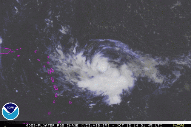
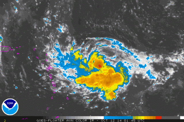
I don't know if they'll be able to wait that long, Luis. Look at that ball of convection popping right over (where I'm pretty sure) the center is. They may have to assess it as a TD or TS before the flight gets out there. Of course ADT from TAFB and CIMSS will help make the determination if they have to upgrade it earlier. (Sure looks like a TD to me.)
RGB satellite:

IR satellite:

0 likes
- Gustywind
- Category 5

- Posts: 12334
- Joined: Mon Sep 03, 2007 7:29 am
- Location: Baie-Mahault, GUADELOUPE
Re: ATL: INVEST 90L - Discussion
ozonepete wrote:cycloneye wrote:A possible TS watch may be issued for PR and VI depending on what the plane finds on Sunday.That is what the latest update of the San Juan NWS says.Read it at the Caribbean thread.
I don't know if they'll be able to wait that long, Luis. Look at that ball of convection popping right over (where I'm pretty sure) the center is. They may have to assess it as a TD or TS before the flight gets out there. Of course ADT from TAFB and CIMSS will help make the determination if they have to upgrade it earlier. (Sure looks like a TD to me.)
RGB satellite:
IR satellite:
Excellent analysis, but which coordinates do you see the possible "center" of 90L?
0 likes
-
ozonepete
- Professional-Met

- Posts: 4743
- Joined: Mon Sep 07, 2009 3:23 pm
- Location: From Ozone Park, NYC / Now in Brooklyn, NY
Re: ATL: INVEST 90L - Discussion
Hammy wrote:If this manages to strengthen sooner, would that tend to cause it to go a bit more north and miss the bulk of the islands?
Don't think so Hammy. I just checked the steering winds for different levels/strengths and they all call for due west movement regardless of strength until at least Monday night / Tuesday.
0 likes
Who is online
Users browsing this forum: No registered users and 52 guests
