
WPAC: USAGI - Typhoon
Moderator: S2k Moderators
-
HurricaneBill
- Category 5

- Posts: 3420
- Joined: Sun Apr 11, 2004 5:51 pm
- Location: East Longmeadow, MA, USA


Re: WPAC: USAGI - Tropical Storm
New peak intensity now up to 90 knots!
WDPN32 PGTW 170300
MSGID/GENADMIN/JOINT TYPHOON WRNCEN PEARL HARBOR HI//
SUBJ/PROGNOSTIC REASONING FOR TROPICAL DEPRESSION 17W (USAGI)
WARNING NR 02//
RMKS/
1. FOR METEOROLOGISTS.
2. 6 HOUR SUMMARY AND ANALYSIS.
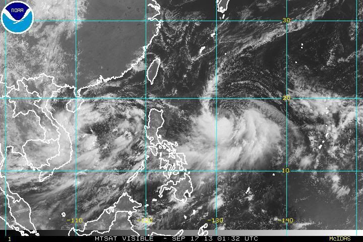
TROPICAL DEPRESSION 17W (USAGI), LOCATED APPROXIMATELY 582 NM
SOUTH-SOUTHEAST OF KADENA AB, HAS TRACKED WEST-SOUTHWESTWARD AT 04
KNOTS OVER THE PAST SIX HOURS. ANIMATED MULTISPECTRAL SATELLITE
IMAGERY SHOWS A PARTIALLY EXPOSED LOW LEVEL CIRCULATION CENTER
(LLCC) THAT HAS BEEN STEADILY CONSOLIDATING INTO A SYMMETRIC
CIRCULATION OVER THE PAST FEW HOURS. A RECENT BLOOM OF DEEP
CONVECTION NEAR THE LLCC HAS RECENTLY DEVELOPED AND IS CURRENTLY
LINKED TO THE BAND OF DEEP CONVECTION THAT HAS PERSISTED WITHIN THE
SOUTHWESTERN QUADRANT. THE SECONDARY BAND OF DEEP CONVECTION IN THE
SOUTH-EASTERN QUADRANT HAS BEEN STRUGGLING TO WRAP FULLY INTO THE
LLCC ALONG THE EASTERN HALF OF THE SYSTEM. THE CURRENT INTENSITY HAS
BEEN INCREASED TO 30 KNOTS BASED ON THE IMPROVING ORGANIZATION TO
THE LLCC AND DVORAK ESTIMATES FROM PGTW, KNES, AND RJTD RANGING FROM
25 TO 35 KNOTS. UPPER LEVEL ANALYSIS INDICATES A POINT-SOURCE
ANTICYCLONE IS DEVELOPING OVER THE LLCC WITH A TROPICAL UPPER
TROPOSPHERIC TROUGH (TUTT) CELL LOCATED TO THE EAST. THE TUTT CELL,
IN ASSOCIATION WITH THE ANTICYCLONE, IS ENHANCING THE OUTFLOW IN THE
EASTERN AND SOUTHERN QUADRANTS. TD 17W IS SLOWLY TRACKING WESTWARD
IN A RELATIVELY WEAK STEERING ENVIRONMENT. THE REMNANTS OF TS 16W
(MAN-YI) HAVE WEAKENED THE DEEP LAYERED SUBTROPICAL RIDGE (STR) THAT
EXTENDS FROM CENTRAL CHINA THROUGH THE CENTRAL PACIFIC LEADING TO TD
17W BEING LOCATED WITHIN A COL REGION.
3. FORECAST REASONING.
A. NO CHANGE TO THE FORECAST PHILOSOPHY SINCE THE PREVIOUS
PROGNOSTIC REASONING MESSAGE.
B. TD 17W IS EXPECTED TO SLOWLY TRACK WESTWARD AS THE REMNANTS OF
TS 16W MOVE TO THE NORTHEAST. THE STR IS EXPECTED TO REBUILD TO THE
NORTH OF TD 17W ALLOWING FOR THE SYSTEM TO INCREASE IN TRACK SPEED
OVER THE NEXT 36 TO 48 HOURS. THE SEA SURFACE TEMPERATURES ALONG THE
FORECAST TRACK ARE FAVORABLE (29 TO 30 CELSIUS) FOR DEVELOPMENT
THROUGHOUT THE FORECAST PERIOD. THE UPPER LEVEL TUTT CELL WILL
CONTINUE TO ENHANCE THE EASTWARD OUTFLOW THROUGH TAU 36 AS IT TRACKS
TO THE WEST-NORTHWEST OVER THE NEXT FEW DAYS. THERE IS SOME CONCERN
REGARDING THE INTERACTION BEYOND TAU 48 AS TD 17W AND THE TUTT CELL
TRACK ON SEPARATE BEARINGS. MODERATELY FAVORABLE OUTFLOW WILL
CONTINUE TO ENHANCE THE DEVELOPMENT OF THE SYSTEM THROUGH TAU 72.
C. IN THE EXTENDED TAUS, TD 17W WILL CONTINUE TO TRACK ALONG THE
SOUTHERN PERIPHERY OF THE STR, TOWARDS THE SOUTHERN TIP OF TAIWAN.
THE OVERALL ENVIRONMENT IS EXPECTED TO REMAIN FAVORABLE THROUGH TAU
96, BUT SHORTLY BEFORE TAU 120, LAND INTERACTION WITH TAIWAN WILL
CAUSE A BRIEF WEAKENING OF THE SYSTEM. NUMERIC MODEL GUIDANCE IS IN
FAIR AGREEMENT WITH THE GENERAL WESTWARD TRACK THROUGH TAU 72, BUT
INDICATES A LARGE VARIATION IN THE AMOUNT OF INTERACTION THE STR
WILL PLAY AS TD 17W APPROACHES TAIWAN. THE CURRENT FORECAST TRACK IS
BASED ON THE CONSENSUS OF AVAILABLE MODEL GUIDANCE. DUE TO THE
VARIATIONS IN MODEL GUIDANCE, CONFIDENCE IN THE FORECAST TRACK
REMAINS LOW.//
NNNN

super favorable for development...
WDPN32 PGTW 170300
MSGID/GENADMIN/JOINT TYPHOON WRNCEN PEARL HARBOR HI//
SUBJ/PROGNOSTIC REASONING FOR TROPICAL DEPRESSION 17W (USAGI)
WARNING NR 02//
RMKS/
1. FOR METEOROLOGISTS.
2. 6 HOUR SUMMARY AND ANALYSIS.
TROPICAL DEPRESSION 17W (USAGI), LOCATED APPROXIMATELY 582 NM
SOUTH-SOUTHEAST OF KADENA AB, HAS TRACKED WEST-SOUTHWESTWARD AT 04
KNOTS OVER THE PAST SIX HOURS. ANIMATED MULTISPECTRAL SATELLITE
IMAGERY SHOWS A PARTIALLY EXPOSED LOW LEVEL CIRCULATION CENTER
(LLCC) THAT HAS BEEN STEADILY CONSOLIDATING INTO A SYMMETRIC
CIRCULATION OVER THE PAST FEW HOURS. A RECENT BLOOM OF DEEP
CONVECTION NEAR THE LLCC HAS RECENTLY DEVELOPED AND IS CURRENTLY
LINKED TO THE BAND OF DEEP CONVECTION THAT HAS PERSISTED WITHIN THE
SOUTHWESTERN QUADRANT. THE SECONDARY BAND OF DEEP CONVECTION IN THE
SOUTH-EASTERN QUADRANT HAS BEEN STRUGGLING TO WRAP FULLY INTO THE
LLCC ALONG THE EASTERN HALF OF THE SYSTEM. THE CURRENT INTENSITY HAS
BEEN INCREASED TO 30 KNOTS BASED ON THE IMPROVING ORGANIZATION TO
THE LLCC AND DVORAK ESTIMATES FROM PGTW, KNES, AND RJTD RANGING FROM
25 TO 35 KNOTS. UPPER LEVEL ANALYSIS INDICATES A POINT-SOURCE
ANTICYCLONE IS DEVELOPING OVER THE LLCC WITH A TROPICAL UPPER
TROPOSPHERIC TROUGH (TUTT) CELL LOCATED TO THE EAST. THE TUTT CELL,
IN ASSOCIATION WITH THE ANTICYCLONE, IS ENHANCING THE OUTFLOW IN THE
EASTERN AND SOUTHERN QUADRANTS. TD 17W IS SLOWLY TRACKING WESTWARD
IN A RELATIVELY WEAK STEERING ENVIRONMENT. THE REMNANTS OF TS 16W
(MAN-YI) HAVE WEAKENED THE DEEP LAYERED SUBTROPICAL RIDGE (STR) THAT
EXTENDS FROM CENTRAL CHINA THROUGH THE CENTRAL PACIFIC LEADING TO TD
17W BEING LOCATED WITHIN A COL REGION.
3. FORECAST REASONING.
A. NO CHANGE TO THE FORECAST PHILOSOPHY SINCE THE PREVIOUS
PROGNOSTIC REASONING MESSAGE.
B. TD 17W IS EXPECTED TO SLOWLY TRACK WESTWARD AS THE REMNANTS OF
TS 16W MOVE TO THE NORTHEAST. THE STR IS EXPECTED TO REBUILD TO THE
NORTH OF TD 17W ALLOWING FOR THE SYSTEM TO INCREASE IN TRACK SPEED
OVER THE NEXT 36 TO 48 HOURS. THE SEA SURFACE TEMPERATURES ALONG THE
FORECAST TRACK ARE FAVORABLE (29 TO 30 CELSIUS) FOR DEVELOPMENT
THROUGHOUT THE FORECAST PERIOD. THE UPPER LEVEL TUTT CELL WILL
CONTINUE TO ENHANCE THE EASTWARD OUTFLOW THROUGH TAU 36 AS IT TRACKS
TO THE WEST-NORTHWEST OVER THE NEXT FEW DAYS. THERE IS SOME CONCERN
REGARDING THE INTERACTION BEYOND TAU 48 AS TD 17W AND THE TUTT CELL
TRACK ON SEPARATE BEARINGS. MODERATELY FAVORABLE OUTFLOW WILL
CONTINUE TO ENHANCE THE DEVELOPMENT OF THE SYSTEM THROUGH TAU 72.
C. IN THE EXTENDED TAUS, TD 17W WILL CONTINUE TO TRACK ALONG THE
SOUTHERN PERIPHERY OF THE STR, TOWARDS THE SOUTHERN TIP OF TAIWAN.
THE OVERALL ENVIRONMENT IS EXPECTED TO REMAIN FAVORABLE THROUGH TAU
96, BUT SHORTLY BEFORE TAU 120, LAND INTERACTION WITH TAIWAN WILL
CAUSE A BRIEF WEAKENING OF THE SYSTEM. NUMERIC MODEL GUIDANCE IS IN
FAIR AGREEMENT WITH THE GENERAL WESTWARD TRACK THROUGH TAU 72, BUT
INDICATES A LARGE VARIATION IN THE AMOUNT OF INTERACTION THE STR
WILL PLAY AS TD 17W APPROACHES TAIWAN. THE CURRENT FORECAST TRACK IS
BASED ON THE CONSENSUS OF AVAILABLE MODEL GUIDANCE. DUE TO THE
VARIATIONS IN MODEL GUIDANCE, CONFIDENCE IN THE FORECAST TRACK
REMAINS LOW.//
NNNN
super favorable for development...
0 likes
Remember, all of my post aren't official. For official warnings and discussions, Please refer to your local NWS products...
NWS for the Western Pacific
https://www.weather.gov/gum/
NWS for the Western Pacific
https://www.weather.gov/gum/
-
Typhoon Hunter
- WesternPacificWeather.com

- Posts: 1215
- Age: 40
- Joined: Wed Oct 11, 2006 11:37 am
- Location: Hong Kong
- Contact:
Re: WPAC: USAGI - Tropical Storm
Big ball of extremely deep convection and up to 40kts now per JMA, impressive!

Uploaded with ImageShack.us

Uploaded with ImageShack.us
0 likes
-
mrbagyo

- Category 5
- Posts: 3615
- Age: 32
- Joined: Thu Apr 12, 2012 9:18 am
- Location: 14.13N 120.98E
- Contact:
Re: WPAC: USAGI - Tropical Storm
Typhoon Hunter wrote:Big ball of extremely deep convection and up to 40kts now per JMA, impressive!
Uploaded with ImageShack.us
what's the likely rainfall rate in the blacks and white zones??? mm/hr??

I'm quite sure Usagi won't poof or should I say JMA's intensity estimate (if JMA just upgraded Rumbia into a typhoon then Usagi should be our 4th):P .. anyway, I believe this is going to be our 3rd official typhoon ...
and this must be our latest forming 3rd official typhoon??.. It already surpassed typhoon Todd of 1998 which became the 3rd official typhoon of 1998 on 17th of September.
Last edited by mrbagyo on Tue Sep 17, 2013 9:30 am, edited 2 times in total.
0 likes
The posts in this forum are NOT official forecast and should not be used as such. They are just the opinion of the poster and may or may not be backed by sound meteorological data. They are NOT endorsed by any professional institution or storm2k.org. For official information, please refer to RSMC, NHC and NWS products.
-
mrbagyo
- Category 5
- Posts: 3615
- Age: 32
- Joined: Thu Apr 12, 2012 9:18 am
- Location: 14.13N 120.98E
- Contact:
Re: WPAC: USAGI - Tropical Storm
TXPQ27 KNES 170902
TCSWNP
A. 17W (USAGI)
B. 17/0832Z
C. 17.3N
D. 131.1E
E. THREE/MTSAT
F. T2.0/2.0/D1.0/24HRS
G. IR/EIR/VIS
H. REMARKS...GREATER THAN 3/10 BANDING FOR DT=2.0. MET AND PT AGREE.
FT IS BASED ON DT.
I. ADDL POSITIONS
NIL
...SALEMI
TPPN11 PGTW 171213
A. TROPICAL STORM 17W (USAGI)
B. 17/1132Z
C. 17.2N
D. 131.0E
E. FIVE/MTSAT
F. T2.5/2.5/D1.0/24HRS STT: D0.5/03HRS
G. IR/EIR
H. REMARKS: 38A/PBO SBC/ANMTN. .40 WRAP YIELDS A DT OF 2.5. PT
AGREES; MET WAS 2.0. DBO DT.
I. ADDITIONAL POSITIONS:
17/0626Z 17.6N 131.6E MMHS
17/0848Z 18.0N 131.4E SSMS
LONG
0 likes
The posts in this forum are NOT official forecast and should not be used as such. They are just the opinion of the poster and may or may not be backed by sound meteorological data. They are NOT endorsed by any professional institution or storm2k.org. For official information, please refer to RSMC, NHC and NWS products.
Re: WPAC: USAGI - Tropical Storm
possible major typhoon landfall for taiwan?
WDPN32 PGTW 171500
MSGID/GENADMIN/JOINT TYPHOON WRNCEN PEARL HARBOR HI//
SUBJ/PROGNOSTIC REASONING FOR TROPICAL STORM 17W (USAGI) WARNING NR
04//
RMKS//
1. FOR METEOROLOGISTS.
2. 6 HOUR SUMMARY AND ANALYSIS.
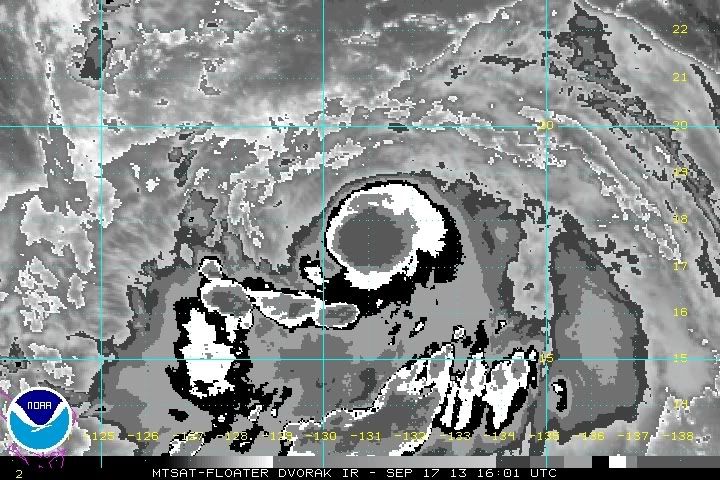
TROPICAL STORM 17W (USAGI), LOCATED APPROXIMATELY 559 NM SOUTH-
SOUTHEAST OF KADENA AB, HAS TRACKED WESTWARD AT 05 KNOTS OVER THE
PAST SIX HOURS. ANIMATED INFRARED SATELLITE IMAGERY SHOWS A
CONSOLIDATING AND PARTIALLY EXPOSED LOW LEVEL CIRCULATION CENTER
(LLCC) THAT HAS BECOME TIGHTER WRAPPED AS A CENTRAL DENSE OVERCAST
FEATURE HAS STARTED TO BUILD ALONG THE SOUTHERN EDGE OF THE LLCC. A
171050Z PARTIAL TRMM MICROWAVE IMAGE SHOWS THE LLCC HAS CONTINUED TO
CONSOLIDATE AND WRAP TIGHTER WHILE THE CONVECTION HAS CONTINUED TO
DEEPEN. THE CURRENT INTENSITY HAS BEEN INCREASED TO 40 KNOTS WHICH
IS SLIGHTLY HIGHER THAN DVORAK INTENSITY ESTIMATES OF 35 KNOTS FROM
PGTW AND RJTD DUE TO THE IMPROVING ORGANIZATION OF THE SYSTEM. UPPER
LEVEL ANALYSIS INDICATES A POINT-SOURCE ANTICYCLONE HAS MOVED OVER
THE LLCC WHILE A TROPICAL UPPER TROPOSPHERIC TROUGH (TUTT) CELL IS
LOCATED TO THE NORTHEAST HAS STARTED TO FILL AND DISSIPATE. THIS IS
OVERALL PROVIDING FAVORABLE EQUATORWARD OUTFLOW AND LOW TO MODERATE
(05-15 KNOTS) VERTICAL WIND SHEAR. TS 17W IS SLOWLY TRACKING
WESTWARD ALONG THE EXTREME SOUTHERN PERIPHERY OF THE SUBTROPICAL
RIDGE NORTH OF THE SYSTEM.
3. FORECAST REASONING.
A. NO CHANGE TO THE FORECAST PHILOSOPHY SINCE THE PREVIOUS
PROGNOSTIC REASONING MESSAGE.
B. TS 17W IS WILL SLOWLY TRACK WESTWARD AS THE STR IS EXPECTED TO
BECOME MORE ESTABLISHED TO THE NORTH OF THE SYSTEM THROUGH THE NEXT
36 HOURS. AFTER TAU 36, A MID-LATITUDE TROUGH IS EXPECTED TO DIG IN
ACROSS NORTHEASTERN CHINA, WHICH WILL SLIGHTLY MODIFY THE STR
ALLOWING FOR TS 17W TO TAKE A MORE NORTHWESTWARD TRACK TOWARDS
SOUTHERN TAIWAN. AN OVERALL FAVORABLE ENVIRONMENT WILL CONTINUE TO
ENHANCE THE DEVELOPMENT OF THE SYSTEM THROUGH TAU 72 ALLOWING FOR A
PEAK INTENSITY OF 95 KNOTS.
C. IN THE EXTENDED TAUS, TS 17W WILL CONTINUE TO TRACK ALONG THE
SOUTHWESTERN PERIPHERY OF THE STR. LAND INTERACTION WITH TAIWAN WILL
CAUSE SLOW WEAKENING AS THE SYSTEM APPROACHES THE SOUTHEASTERN COAST
NEAR TAU 96. NUMERIC MODEL GUIDANCE IS IN FAIR AGREEMENT WITH THE
GENERAL WESTWARD TO NORTHWESTWARD TRACK THROUGH TAU 72, BUT THERE
CONTINUES TO BE VARIATIONS IN THE ORIENTATION OF STR AS TS 17W
APPROACHES TAIWAN. THE CURRENT FORECAST TRACK IS LAID CLOSE TO MULTI-
MODEL CONSENSUS WITH LOW, BUT IMPROVING CONFIDENCE AS THE MODELS
CONTINUE TO MOVE INTO BETTER AGREEMENT WITH THE FORECAST TRACK.//
NNNN
WDPN32 PGTW 171500
MSGID/GENADMIN/JOINT TYPHOON WRNCEN PEARL HARBOR HI//
SUBJ/PROGNOSTIC REASONING FOR TROPICAL STORM 17W (USAGI) WARNING NR
04//
RMKS//
1. FOR METEOROLOGISTS.
2. 6 HOUR SUMMARY AND ANALYSIS.
TROPICAL STORM 17W (USAGI), LOCATED APPROXIMATELY 559 NM SOUTH-
SOUTHEAST OF KADENA AB, HAS TRACKED WESTWARD AT 05 KNOTS OVER THE
PAST SIX HOURS. ANIMATED INFRARED SATELLITE IMAGERY SHOWS A
CONSOLIDATING AND PARTIALLY EXPOSED LOW LEVEL CIRCULATION CENTER
(LLCC) THAT HAS BECOME TIGHTER WRAPPED AS A CENTRAL DENSE OVERCAST
FEATURE HAS STARTED TO BUILD ALONG THE SOUTHERN EDGE OF THE LLCC. A
171050Z PARTIAL TRMM MICROWAVE IMAGE SHOWS THE LLCC HAS CONTINUED TO
CONSOLIDATE AND WRAP TIGHTER WHILE THE CONVECTION HAS CONTINUED TO
DEEPEN. THE CURRENT INTENSITY HAS BEEN INCREASED TO 40 KNOTS WHICH
IS SLIGHTLY HIGHER THAN DVORAK INTENSITY ESTIMATES OF 35 KNOTS FROM
PGTW AND RJTD DUE TO THE IMPROVING ORGANIZATION OF THE SYSTEM. UPPER
LEVEL ANALYSIS INDICATES A POINT-SOURCE ANTICYCLONE HAS MOVED OVER
THE LLCC WHILE A TROPICAL UPPER TROPOSPHERIC TROUGH (TUTT) CELL IS
LOCATED TO THE NORTHEAST HAS STARTED TO FILL AND DISSIPATE. THIS IS
OVERALL PROVIDING FAVORABLE EQUATORWARD OUTFLOW AND LOW TO MODERATE
(05-15 KNOTS) VERTICAL WIND SHEAR. TS 17W IS SLOWLY TRACKING
WESTWARD ALONG THE EXTREME SOUTHERN PERIPHERY OF THE SUBTROPICAL
RIDGE NORTH OF THE SYSTEM.
3. FORECAST REASONING.
A. NO CHANGE TO THE FORECAST PHILOSOPHY SINCE THE PREVIOUS
PROGNOSTIC REASONING MESSAGE.
B. TS 17W IS WILL SLOWLY TRACK WESTWARD AS THE STR IS EXPECTED TO
BECOME MORE ESTABLISHED TO THE NORTH OF THE SYSTEM THROUGH THE NEXT
36 HOURS. AFTER TAU 36, A MID-LATITUDE TROUGH IS EXPECTED TO DIG IN
ACROSS NORTHEASTERN CHINA, WHICH WILL SLIGHTLY MODIFY THE STR
ALLOWING FOR TS 17W TO TAKE A MORE NORTHWESTWARD TRACK TOWARDS
SOUTHERN TAIWAN. AN OVERALL FAVORABLE ENVIRONMENT WILL CONTINUE TO
ENHANCE THE DEVELOPMENT OF THE SYSTEM THROUGH TAU 72 ALLOWING FOR A
PEAK INTENSITY OF 95 KNOTS.
C. IN THE EXTENDED TAUS, TS 17W WILL CONTINUE TO TRACK ALONG THE
SOUTHWESTERN PERIPHERY OF THE STR. LAND INTERACTION WITH TAIWAN WILL
CAUSE SLOW WEAKENING AS THE SYSTEM APPROACHES THE SOUTHEASTERN COAST
NEAR TAU 96. NUMERIC MODEL GUIDANCE IS IN FAIR AGREEMENT WITH THE
GENERAL WESTWARD TO NORTHWESTWARD TRACK THROUGH TAU 72, BUT THERE
CONTINUES TO BE VARIATIONS IN THE ORIENTATION OF STR AS TS 17W
APPROACHES TAIWAN. THE CURRENT FORECAST TRACK IS LAID CLOSE TO MULTI-
MODEL CONSENSUS WITH LOW, BUT IMPROVING CONFIDENCE AS THE MODELS
CONTINUE TO MOVE INTO BETTER AGREEMENT WITH THE FORECAST TRACK.//
NNNN
0 likes
Remember, all of my post aren't official. For official warnings and discussions, Please refer to your local NWS products...
NWS for the Western Pacific
https://www.weather.gov/gum/
NWS for the Western Pacific
https://www.weather.gov/gum/
Re: WPAC: USAGI - Tropical Storm

very warm core...

impressive...
0 likes
Remember, all of my post aren't official. For official warnings and discussions, Please refer to your local NWS products...
NWS for the Western Pacific
https://www.weather.gov/gum/
NWS for the Western Pacific
https://www.weather.gov/gum/
Re: WPAC: USAGI - Tropical Storm
We may be witnessing the strongest september TC in any basin this year...incredible how the monster wpac continues to produce strong TC in any given years that are considered slow or active...it's like the wpac is destined for a strong typhoon every year hitting landmassrd with millions of people...
0 likes
Remember, all of my post aren't official. For official warnings and discussions, Please refer to your local NWS products...
NWS for the Western Pacific
https://www.weather.gov/gum/
NWS for the Western Pacific
https://www.weather.gov/gum/
-
cycloneye

- Admin

- Posts: 139346
- Age: 67
- Joined: Thu Oct 10, 2002 10:54 am
- Location: San Juan, Puerto Rico
Re: WPAC: USAGI - Tropical Storm
Hi James,are you planning to chase Usagi in Taiwan?
0 likes
Visit the Caribbean-Central America Weather Thread where you can find at first post web cams,radars
and observations from Caribbean basin members Click Here
and observations from Caribbean basin members Click Here
-
Extratropical94

- Professional-Met

- Posts: 3535
- Age: 29
- Joined: Wed Oct 20, 2010 6:36 am
- Location: Hamburg, Germany
- Contact:
'Major' trouble ahead according to JTWC.
TROPICAL STORM 17W (USAGI) WARNING NR 005
01 ACTIVE TROPICAL CYCLONE IN NORTHWESTPAC
MAX SUSTAINED WINDS BASED ON ONE-MINUTE AVERAGE
WIND RADII VALID OVER OPEN WATER ONLY
---
WARNING POSITION:
171800Z --- NEAR 17.6N 130.3E
MOVEMENT PAST SIX HOURS - 270 DEGREES AT 05 KTS
POSITION ACCURATE TO WITHIN 030 NM
POSITION BASED ON CENTER LOCATED BY SATELLITE
PRESENT WIND DISTRIBUTION:
MAX SUSTAINED WINDS - 050 KT, GUSTS 065 KT
WIND RADII VALID OVER OPEN WATER ONLY
RADIUS OF 034 KT WINDS - 050 NM NORTHEAST QUADRANT
065 NM SOUTHEAST QUADRANT
060 NM SOUTHWEST QUADRANT
045 NM NORTHWEST QUADRANT
REPEAT POSIT: 17.6N 130.3E
---
FORECASTS:
12 HRS, VALID AT:
180600Z --- 17.6N 129.2E
MAX SUSTAINED WINDS - 065 KT, GUSTS 080 KT
WIND RADII VALID OVER OPEN WATER ONLY
RADIUS OF 050 KT WINDS - 035 NM NORTHEAST QUADRANT
040 NM SOUTHEAST QUADRANT
035 NM SOUTHWEST QUADRANT
035 NM NORTHWEST QUADRANT
RADIUS OF 034 KT WINDS - 080 NM NORTHEAST QUADRANT
090 NM SOUTHEAST QUADRANT
085 NM SOUTHWEST QUADRANT
080 NM NORTHWEST QUADRANT
VECTOR TO 24 HR POSIT: 275 DEG/ 06 KTS
---
24 HRS, VALID AT:
181800Z --- 17.7N 127.9E
MAX SUSTAINED WINDS - 075 KT, GUSTS 090 KT
WIND RADII VALID OVER OPEN WATER ONLY
RADIUS OF 064 KT WINDS - 025 NM NORTHEAST QUADRANT
025 NM SOUTHEAST QUADRANT
025 NM SOUTHWEST QUADRANT
025 NM NORTHWEST QUADRANT
RADIUS OF 050 KT WINDS - 045 NM NORTHEAST QUADRANT
045 NM SOUTHEAST QUADRANT
045 NM SOUTHWEST QUADRANT
045 NM NORTHWEST QUADRANT
RADIUS OF 034 KT WINDS - 100 NM NORTHEAST QUADRANT
105 NM SOUTHEAST QUADRANT
100 NM SOUTHWEST QUADRANT
100 NM NORTHWEST QUADRANT
VECTOR TO 36 HR POSIT: 290 DEG/ 07 KTS
---
36 HRS, VALID AT:
190600Z --- 18.1N 126.6E
MAX SUSTAINED WINDS - 085 KT, GUSTS 105 KT
WIND RADII VALID OVER OPEN WATER ONLY
RADIUS OF 064 KT WINDS - 030 NM NORTHEAST QUADRANT
030 NM SOUTHEAST QUADRANT
030 NM SOUTHWEST QUADRANT
030 NM NORTHWEST QUADRANT
RADIUS OF 050 KT WINDS - 055 NM NORTHEAST QUADRANT
055 NM SOUTHEAST QUADRANT
055 NM SOUTHWEST QUADRANT
055 NM NORTHWEST QUADRANT
RADIUS OF 034 KT WINDS - 115 NM NORTHEAST QUADRANT
115 NM SOUTHEAST QUADRANT
110 NM SOUTHWEST QUADRANT
110 NM NORTHWEST QUADRANT
VECTOR TO 48 HR POSIT: 295 DEG/ 07 KTS
---
EXTENDED OUTLOOK:
48 HRS, VALID AT:
191800Z --- 18.7N 125.2E
MAX SUSTAINED WINDS - 095 KT, GUSTS 115 KT
WIND RADII VALID OVER OPEN WATER ONLY
RADIUS OF 064 KT WINDS - 035 NM NORTHEAST QUADRANT
035 NM SOUTHEAST QUADRANT
035 NM SOUTHWEST QUADRANT
035 NM NORTHWEST QUADRANT
RADIUS OF 050 KT WINDS - 060 NM NORTHEAST QUADRANT
060 NM SOUTHEAST QUADRANT
060 NM SOUTHWEST QUADRANT
060 NM NORTHWEST QUADRANT
RADIUS OF 034 KT WINDS - 125 NM NORTHEAST QUADRANT
120 NM SOUTHEAST QUADRANT
120 NM SOUTHWEST QUADRANT
120 NM NORTHWEST QUADRANT
VECTOR TO 72 HR POSIT: 310 DEG/ 08 KTS
---
72 HRS, VALID AT:
201800Z --- 20.6N 122.7E
MAX SUSTAINED WINDS - 105 KT, GUSTS 130 KT
WIND RADII VALID OVER OPEN WATER ONLY
RADIUS OF 064 KT WINDS - 040 NM NORTHEAST QUADRANT
040 NM SOUTHEAST QUADRANT
040 NM SOUTHWEST QUADRANT
040 NM NORTHWEST QUADRANT
RADIUS OF 050 KT WINDS - 070 NM NORTHEAST QUADRANT
065 NM SOUTHEAST QUADRANT
065 NM SOUTHWEST QUADRANT
065 NM NORTHWEST QUADRANT
RADIUS OF 034 KT WINDS - 130 NM NORTHEAST QUADRANT
130 NM SOUTHEAST QUADRANT
125 NM SOUTHWEST QUADRANT
130 NM NORTHWEST QUADRANT
VECTOR TO 96 HR POSIT: 310 DEG/ 07 KTS
---
LONG RANGE OUTLOOK:
---
96 HRS, VALID AT:
211800Z --- 22.3N 120.3E
MAX SUSTAINED WINDS - 095 KT, GUSTS 115 KT
WIND RADII VALID OVER OPEN WATER ONLY
VECTOR TO 120 HR POSIT: 295 DEG/ 08 KTS
---
120 HRS, VALID AT:
221800Z --- 23.5N 117.1E
MAX SUSTAINED WINDS - 080 KT, GUSTS 100 KT
WIND RADII VALID OVER OPEN WATER ONLY
---
REMARKS:
172100Z POSITION NEAR 17.6N 130.0E.
TROPICAL STORM 17W (USAGI), LOCATED APPROXIMATELY 552 NM SOUTH-
SOUTHEAST OF KADENA AB, HAS TRACKED WESTWARD AT 05 KNOTS OVER THE
PAST SIX HOURS. MAXIMUM SIGNIFICANT WAVE HEIGHT AT 171800Z IS 12
FEET. NEXT WARNINGS AT 180300Z, 180900Z, 181500Z AND 182100Z.//
0 likes
54° 11' 59'' N, 9° 9' 20'' E
Boomer Sooner!
Go Broncos! Go Cards! Go Niners!
- Daniel
Boomer Sooner!
Go Broncos! Go Cards! Go Niners!
- Daniel
Re: WPAC: USAGI - Tropical Storm
wow!
intensity landfall keeps going up, now 105 knots!
this storm should get more recon than all those weak storms in the western hemisphere!
CI# /Pressure/ Vmax
3.5 / 988.5mb/ 55.0kt
Final T# Adj T# Raw T#
3.5 3.7 3.7
Looks like JTWC might increase intensity to near 55 knots...
intensity landfall keeps going up, now 105 knots!
this storm should get more recon than all those weak storms in the western hemisphere!
CI# /Pressure/ Vmax
3.5 / 988.5mb/ 55.0kt
Final T# Adj T# Raw T#
3.5 3.7 3.7
Looks like JTWC might increase intensity to near 55 knots...
0 likes
Remember, all of my post aren't official. For official warnings and discussions, Please refer to your local NWS products...
NWS for the Western Pacific
https://www.weather.gov/gum/
NWS for the Western Pacific
https://www.weather.gov/gum/
105 knots may be low, IMO.
Personal Forecast Disclaimer:
The posts in this forum are NOT official forecast and should not be used as such. They are just the opinion of the poster and may or may not be backed by sound meteorological data. They are NOT endorsed by any professional institution or storm2k.org. For official information, please refer to the NHC and NWS products.
0 likes
-
Meow
JMA upgraded Usagi to a severe tropical storm.

STS 1319 (USAGI)
Issued at 00:45 UTC, 18 September 2013
<Analyses at 18/00 UTC>
Scale -
Intensity -
Center position N17°10'(17.2°)
E130°25'(130.4°)
Direction and speed of movement Almost stationary
Central pressure 985hPa
Maximum wind speed near the center 25m/s(50kt)
Maximum wind gust speed 35m/s(70kt)
Area of 30kt winds or more ALL330km(180NM)
<Forecast for 19/00 UTC>
Intensity -
Center position of probability circle N17°50'(17.8°)
E127°50'(127.8°)
Direction and speed of movement W 10km/h(6kt)
Central pressure 975hPa
Maximum wind speed near the center 30m/s(60kt)
Maximum wind gust speed 45m/s(85kt)
Radius of probability circle 130km(70NM)
Storm warning area ALL220km(120NM)
<Forecast for 20/00 UTC>
Intensity Strong
Center position of probability circle N19°25'(19.4°)
E124°50'(124.8°)
Direction and speed of movement WNW 15km/h(8kt)
Central pressure 965hPa
Maximum wind speed near the center 35m/s(70kt)
Maximum wind gust speed 50m/s(100kt)
Radius of probability circle 200km(110NM)
Storm warning area ALL330km(180NM)
<Forecast for 21/00 UTC>
Intensity Strong
Center position of probability circle N21°30'(21.5°)
E121°35'(121.6°)
Direction and speed of movement NW 15km/h(9kt)
Central pressure 955hPa
Maximum wind speed near the center 40m/s(75kt)
Maximum wind gust speed 55m/s(105kt)
Radius of probability circle 300km(160NM)
Storm warning area ALL440km(240NM)
0 likes
-
dexterlabio
- Category 5
- Posts: 3408
- Joined: Sat Oct 24, 2009 11:50 pm
Re: WPAC: USAGI - Severe Tropical Storm
Is there a bit of dry air issue within Usagi? Yesterday there was an impressive ball of very deep convection but now it's gone.... although, we can now see how tight and organized the circulation is, plus a hint of an eyewall forming.
IMO Usagi might not only be posing serious threat to extreme north Luzon and southern Taiwan. If the core passes just in between Luzon and Taiwan (unscathed by land interaction), Southern China might feel the full brunt of its force..maybe including Hongkong. BTW we have a flight to HK on the 23rd then from HK, we'll be taking a flight going to San Francisco. I'm starting to wonder if our flight will be affected.
Personal Forecast Disclaimer:
The posts in this forum are NOT official forecast and should not be used as such. They are just the opinion of the poster and may or may not be backed by sound meteorological data. They are NOT endorsed by any professional institution or storm2k.org.
0 likes
Personal Forecast Disclaimer:
The posts in this forum are NOT official forecast and should not be used as such. They are just the opinion of the poster and may or may not be backed by sound meteorological data. They are NOT endorsed by any professional institution or storm2k.org. For official information, please refer to the NHC and NWS products.
The posts in this forum are NOT official forecast and should not be used as such. They are just the opinion of the poster and may or may not be backed by sound meteorological data. They are NOT endorsed by any professional institution or storm2k.org. For official information, please refer to the NHC and NWS products.
-
dexterlabio
- Category 5
- Posts: 3408
- Joined: Sat Oct 24, 2009 11:50 pm
OT: Our official typhoons so far are Soulik and Utor, and both were strong Cat4 typhoons (or 100+ knot typhoons, 10-min average). We may have the record of lowest number of typhoons to date but all of the typhoons we've had were intense, reaching major category (Cat3 and above). And now, Usagi is likely to be our 3rd official typhoon, and possibly the 3rd intense typhoon of the season. I think it will be cool if we get a record low number of typhoons but all intense ones by the end of the season.
0 likes
Personal Forecast Disclaimer:
The posts in this forum are NOT official forecast and should not be used as such. They are just the opinion of the poster and may or may not be backed by sound meteorological data. They are NOT endorsed by any professional institution or storm2k.org. For official information, please refer to the NHC and NWS products.
The posts in this forum are NOT official forecast and should not be used as such. They are just the opinion of the poster and may or may not be backed by sound meteorological data. They are NOT endorsed by any professional institution or storm2k.org. For official information, please refer to the NHC and NWS products.
Re: WPAC: USAGI - Severe Tropical Storm
WDPN32 PGTW 180300
MSGID/GENADMIN/JOINT TYPHOON WRNCEN PEARL HARBOR HI//
SUBJ/PROGNOSTIC REASONING FOR TROPICAL STORM 17W (USAGI) WARNING NR
06//
RMKS/
1. FOR METEOROLOGISTS.
2. 6 HOUR SUMMARY AND ANALYSIS.
TROPICAL STORM 17W (USAGI), LOCATED APPROXIMATELY 560 NM EAST-
NORTHEAST OF MANILA, PHILIPPINES, HAS TRACKED WESTWARD AT 03 KNOTS
OVER THE PAST SIX HOURS. ANIMATED MULTISPECTRAL SATELLITE IMAGERY
(MSI) SHOWED A SLIGHT WEAKENING OF THE CENTRAL CONVECTION OVER THE
LOW LEVEL CIRCULATION CENTER (LLCC) IN THE EARLY HOURS OF THE LAST
FORECAST, BUT THE CORE OF DEEP CONVECTION HAS MADE A RESURGENCE AS
THE OUTFLOW ALONG THE PERIPHERY HAS BECOME MORE RADIAL IN NATURE
OVER THE PAST THREE TO SIX HOURS. BROKEN BANDS OF DEEP CONVECTION
ALONG THE SOUTHERN AND EASTERN PERIPHERY HAVE BEEN BUILDING AS THE
RADIAL OUTFLOW IMPROVES. THE CURRENT INTENSITY HAS BEEN MAINTAINED
AT 50 KNOTS AS DVORAK ESTIMATES AND THE CONVECTIVE STRUCTURE OF THE
SYSTEM HAS REMAINED FAIRLY STEADY OVER THE PAST SIX HOURS. UPPER
LEVEL ANALYSIS INDICATES THE POINT-SOURCE ANTICYCLONE HAS PERSISTED
OVER THE LLCC AND HAS BEEN THE PRIMARY FACTOR IN THE RECENT
IMPROVEMENT OF THE RADIAL OUTFLOW. TS 17W IS SLOWLY TRACKING
WESTWARD ALONG THE EXTREME SOUTHERN PERIPHERY OF A SUBTROPICAL RIDGE
(STR) THAT EXTENDS FROM CENTRAL CHINA THROUGH THE NORTHWESTERN
PACIFIC.
3. FORECAST REASONING.
A. THE FORECAST TRACK HAS BEEN SHIFTED SOUTHWARD AWAY FROM
TAIWAN, AS MODEL GUIDANCE HAS CONTINUED TO IMPROVE INDICATING A MORE
SOUTHERLY TRACK OF THE SYSTEM IN THE EXTENDED TAUS.
B. TS 17W WILL TRACK WESTWARD UNDER THE INFLUENCE OF THE STR TO
THE NORTH FOR THE NEXT 24 HOURS UNTIL A MID-LATITUDE TROUGH OVER
NORTHERN CHINA WEAKENS THE WESTERN EXTENT OF THE STR. THE STR IS NOT
EXPECTED TO FULLY BREAK DOWN, BUT WILL ALLOW TS 17W TO TURN TO THE
WEST-NORTHWEST THROUGH TAU 72. FAVORABLE SEA SURFACE TEMPERATURES
ALONG THE FORECAST TRACK (29 TO 30 CELSIUS) WITH A FAVORABLE UPPER
LEVEL ENVIRONMENT WILL SUPPORT THE INTENSIFICATION OF THE SYSTEM
THROUGH TAU 72 TO A PEAK INTENSITY OF 105 KNOTS.
C. IN THE EXTENDED TAUS, THE FORECAST TRACK IS EXPECTED TO
FLATTEN WESTWARD AS THE MID-LATITUDE TROUGH PROPAGATES EASTWARD
ALLOWING FOR THE STR TO RE-DEVELOP OVER THE SYSTEM. LAND INTERACTION
WITH TAIWAN FROM TAU 72 THROUGH TAU 96 WILL INTERRUPT THE LOW LEVEL
FLOW, LEADING TO A WEAKENING TREND THROUGH THE REMAINDER OF THE
FORECAST. BY TAU 120 SIMILAR LAND EFFECTS WITH COASTAL CHINA WILL
KEEP TS 17W ON A WEAKENING TREND. MODEL GUIDANCE THROUGH TAU 72
REMAINS IN GOOD AGREEMENT, LEADING TO HIGH CONFIDENCE IN THE
SHORT TO MID TERM FORECAST TRACK. OVER THE PAST SIX HOURS MODEL
GUIDANCE HAS IMPROVED FOR THE EXTENDED FORECAST PERIODS LEADING TO
HIGH CONFIDENCE IN THE EXTENDED FORECAST TRACK AS WELL.//
NNNN
0 likes
Remember, all of my post aren't official. For official warnings and discussions, Please refer to your local NWS products...
NWS for the Western Pacific
https://www.weather.gov/gum/
NWS for the Western Pacific
https://www.weather.gov/gum/
Re:
dexterlabio wrote:OT: Our official typhoons so far are Soulik and Utor, and both were strong Cat4 typhoons (or 100+ knot typhoons, 10-min average). We may have the record of lowest number of typhoons to date but all of the typhoons we've had were intense, reaching major category (Cat3 and above). And now, Usagi is likely to be our 3rd official typhoon, and possibly the 3rd intense typhoon of the season. I think it will be cool if we get a record low number of typhoons but all intense ones by the end of the season.
As for 1-min average, we are already at 5 typhoons with 2 major typhoons peaking at 125 and 130 knots...
Usagi is likely going to develop into our 6th typhoon of the season and possibly 3rd major thus far...still a very slow season...
0 likes
Remember, all of my post aren't official. For official warnings and discussions, Please refer to your local NWS products...
NWS for the Western Pacific
https://www.weather.gov/gum/
NWS for the Western Pacific
https://www.weather.gov/gum/
Who is online
Users browsing this forum: No registered users and 12 guests