ATL: INVEST 94L - Discussion

Moderator: S2k Moderators

Message
Author
ozonepete
Professional-Met
Professional-Met
Posts: 4743
Joined: Mon Sep 07, 2009 3:23 pm
Location: From Ozone Park, NYC / Now in Brooklyn, NY

Re: ATL: INVEST 94L - Discussion

#41 Postby ozonepete » Fri Jul 05, 2013 4:47 pm

HurricaneBrain wrote:
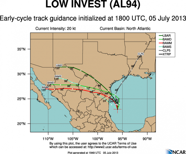
LaBreeze wrote:Is this "system" more likely to go inland south of Corpus Christi, between Corpus and Galveston, or between Galveston and Sabine Pass?

Models show the low moving south of Corpus Christi, which I don't quite understand. I see the ridge allowing the low to continue it's northward trek, but models disagree as of now.


The Bermuda High ridge is expected to build westward - that's probably why the models turn it westward pretty suddenly. We need to see how quickly heights rise over the northern GOM in the next 24 hours. The less it builds in the more northerly this can get.
0 likes   

ozonepete
Professional-Met
Professional-Met
Posts: 4743
Joined: Mon Sep 07, 2009 3:23 pm
Location: From Ozone Park, NYC / Now in Brooklyn, NY

Re: ATL: INVEST 94L - Models

#42 Postby ozonepete » Fri Jul 05, 2013 4:48 pm

Here's the 18Z afternoon runs graphic from Colorado State...

Image
0 likes   

User avatar
wxman57
Moderator-Pro Met
Moderator-Pro Met
Posts: 22484
Age: 66
Joined: Sat Jun 21, 2003 8:06 pm
Location: Houston, TX (southwest)

Re: ATL: INVEST 94L - Discussion

#43 Postby wxman57 » Fri Jul 05, 2013 4:54 pm

If there is an identifiable surface feature then it may well move ashore south of Texas on Sunday. However, the trof axis should extend well to the north, bringing beneficial rain to much of the TX coast. Development chances are low, and even if it was designated a TD or weak TS there would not likely be any wind issues inland. It's a rainfall event, something Texas needs.
0 likes   

User avatar
Tireman4
S2K Supporter
S2K Supporter
Posts: 5674
Age: 58
Joined: Fri Jun 30, 2006 1:08 pm
Location: Humble, Texas
Contact:

Re: ATL: INVEST 94L - Discussion

#44 Postby Tireman4 » Fri Jul 05, 2013 4:59 pm

wxman57 wrote:If there is an identifiable surface feature then it may well move ashore south of Texas on Sunday. However, the trof axis should extend well to the north, bringing beneficial rain to much of the TX coast. Development chances are low, and even if it was designated a TD or weak TS there would not likely be any wind issues inland. It's a rainfall event, something Texas needs.


As usual, thanks Wxman 57. We appreciate your thoughts...
0 likes   

tolakram
Admin
Admin
Posts: 19171
Age: 60
Joined: Sun Aug 27, 2006 8:23 pm
Location: Florence, KY (name is Mark)

Re: ATL: INVEST 94L - Discussion

#45 Postby tolakram » Fri Jul 05, 2013 5:05 pm

0 likes   
M a r k
- - - - -
Join us in chat: Storm2K Chatroom Invite. Android and IOS apps also available.

The posts in this forum are NOT official forecasts and should not be used as such. Posts are NOT endorsed by any professional institution or STORM2K.org. For official information and forecasts, please refer to NHC and NWS products.

User avatar
wxman57
Moderator-Pro Met
Moderator-Pro Met
Posts: 22484
Age: 66
Joined: Sat Jun 21, 2003 8:06 pm
Location: Houston, TX (southwest)

Re: ATL: INVEST 94L - Discussion

#46 Postby wxman57 » Fri Jul 05, 2013 5:11 pm

This is just the thing Texas needs - a broad, slow-moving disturbance to bring beneficial rain to the area. Let's hope the rain makes a good bit inland.
0 likes   

PauleinHouston
Tropical Storm
Tropical Storm
Posts: 102
Joined: Mon Aug 13, 2007 10:23 am
Location: League City, TX
Contact:

Re: ATL: INVEST 94L - Discussion

#47 Postby PauleinHouston » Fri Jul 05, 2013 5:16 pm

wxman57 wrote:This is just the thing Texas needs - a broad, slow-moving disturbance to bring beneficial rain to the area. Let's hope the rain makes a good bit inland.


Wxman57...as always, your insight is very much appreciated! Based upon what you see, where do you see the "inland" component of rain making it to? The trough lifting will help S/E Texas it appears, but wondering about S/Central and Cen Texas areas?
0 likes   
The posts in this forum are NOT official forecasts and should not be used as such. They are just the opinion of this amateur poster and may or may not be backed by sound meteorological data. They are NOT endorsed by any professional institution or storm2k.org. For official information, please refer to NWS products.

User avatar
TexWx
Category 1
Category 1
Posts: 370
Joined: Tue Aug 22, 2006 11:00 pm
Location: Pearland, Texas
Contact:

Re: ATL: INVEST 94L - Discussion

#48 Postby TexWx » Fri Jul 05, 2013 5:25 pm

wxman57 wrote:This is just the thing Texas needs - a broad, slow-moving disturbance to bring beneficial rain to the area. Let's hope the rain makes a good bit inland.


Definitely a nice set up, if this pans out.
0 likes   

User avatar
StormTracker
S2K Supporter
S2K Supporter
Posts: 2902
Age: 57
Joined: Thu Jun 29, 2006 6:06 am
Location: Quail Heights(Redlands), FL.

Re: ATL: INVEST 94L - Discussion

#49 Postby StormTracker » Fri Jul 05, 2013 5:26 pm

Can any pro-met make any sense of this or should I be looking at another chart? Ozone or wxman57, maybe one of you can elaborate on this? Does this show the Bermuda High sliding further west?
http://www.weathercharts.org/noaa-charts.htm#t96-mslp
Last edited by StormTracker on Fri Jul 05, 2013 5:33 pm, edited 1 time in total.
0 likes   
Something's wrong when you regret, things that haven't happened yet!

User avatar
KatDaddy
Category 5
Category 5
Posts: 2815
Joined: Mon Oct 21, 2002 6:23 pm
Location: League City, Texas

Re: ATL: INVEST 94L - Discussion

#50 Postby KatDaddy » Fri Jul 05, 2013 5:29 pm

So true wxman57. We really need significant rainfall well inland.
0 likes   
The following post is NOT an official forecast and should not be used as such. It is just the opinion of the poster and may or may not be backed by sound meteorological data. It is NOT endorsed by any professional institution including storm2k.org For Official Information please refer to the NHC and NWS products.

User avatar
vbhoutex
Storm2k Executive
Storm2k Executive
Posts: 28976
Age: 72
Joined: Wed Oct 09, 2002 11:31 pm
Location: Spring Branch area, Houston, TX
Contact:

Re: ATL: INVEST 94L - Discussion

#51 Postby vbhoutex » Fri Jul 05, 2013 5:34 pm

Won't 94L have the possibility/probability of tapping into the moisture slowly retrograding West towards us from the E GOM? This is the trough(?) that has given the panhandle of FL over a foot of rain in some areas in the last 48 hours.
0 likes   
Skywarn, C.E.R.T.
Please click below to donate to STORM2K to help with the expenses of keeping the site going:
Image

User avatar
southerngale
Retired Staff
Retired Staff
Posts: 27420
Joined: Thu Oct 10, 2002 1:27 am
Location: Southeast Texas (Beaumont area)

#52 Postby southerngale » Fri Jul 05, 2013 5:35 pm

Hopefully, this will pan out to bring the much needed rain to many parts of Texas. A rainmaker without the destructive winds is exactly what is needed.


Image
0 likes   
Please support Storm2k by making a donation today. It is greatly appreciated! Click here: Image

Image my Cowboys Image my RocketsImage my Astros

User avatar
South Texas Storms
Professional-Met
Professional-Met
Posts: 4019
Joined: Thu Jun 24, 2010 12:28 am
Location: Houston, TX

Re: ATL: INVEST 94L - Discussion

#53 Postby South Texas Storms » Fri Jul 05, 2013 5:54 pm

Unfortunately the models aren't showing much rain making it at least 50 miles inland for some reason. I don't know why. Hopefully they bust.
0 likes   

djmikey
Tropical Storm
Tropical Storm
Posts: 151
Joined: Tue Jul 20, 2010 6:04 pm
Location: Beaumont, TX

Re: ATL: INVEST 94L - Models

#54 Postby djmikey » Fri Jul 05, 2013 5:54 pm

:?: Wait. I'm confused. Why are the models wanting to bring this into the Brownsville area? I thought 94L was headed to the upper TX coast. 3 solid days of the talk of TX/LA border.....What just happened?
0 likes   

ozonepete
Professional-Met
Professional-Met
Posts: 4743
Joined: Mon Sep 07, 2009 3:23 pm
Location: From Ozone Park, NYC / Now in Brooklyn, NY

Re: ATL: INVEST 94L - Discussion

#55 Postby ozonepete » Fri Jul 05, 2013 5:58 pm

South Texas Storms wrote:Unfortunately the models aren't showing much rain making it at least 50 miles inland for some reason. I don't know why. Hopefully they bust.


Well it's early yet. They will probably be showing a lot more rain and more of it to the west and north with the next couple of runs.

Personal Forecast Disclaimer:
The posts in this forum are NOT official forecast and should not be used as such. They are just the opinion of the poster and may or may not be backed by sound meteorological data. They are NOT endorsed by any professional institution or storm2k.org. For official information, please refer to the NHC and NWS products.
0 likes   

User avatar
southerngale
Retired Staff
Retired Staff
Posts: 27420
Joined: Thu Oct 10, 2002 1:27 am
Location: Southeast Texas (Beaumont area)

Re: ATL: INVEST 94L - Models

#56 Postby southerngale » Fri Jul 05, 2013 6:00 pm

djmikey wrote::?: Wait. I'm confused. Why are the models wanting to bring this into the Brownsville area? I thought 94L was headed to the upper TX coast. 3 solid days of the talk of TX/LA border.....What just happened?


Nothing happened. We should get rain. See this in the discussion thread.
0 likes   
Please support Storm2k by making a donation today. It is greatly appreciated! Click here: Image

Image my Cowboys Image my RocketsImage my Astros

User avatar
South Texas Storms
Professional-Met
Professional-Met
Posts: 4019
Joined: Thu Jun 24, 2010 12:28 am
Location: Houston, TX

Re: ATL: INVEST 94L - Discussion

#57 Postby South Texas Storms » Fri Jul 05, 2013 6:03 pm

ozonepete wrote:
South Texas Storms wrote:Unfortunately the models aren't showing much rain making it at least 50 miles inland for some reason. I don't know why. Hopefully they bust.


Well it's early yet. They will probably be showing a lot more rain and more of it to the west and north with the next couple of runs.

Personal Forecast Disclaimer:
The posts in this forum are NOT official forecast and should not be used as such. They are just the opinion of the poster and may or may not be backed by sound meteorological data. They are NOT endorsed by any professional institution or storm2k.org. For official information, please refer to the NHC and NWS products.


Why do you think that? They have been consistently showing rainfall totals over an inch only along the coast.
0 likes   

ozonepete
Professional-Met
Professional-Met
Posts: 4743
Joined: Mon Sep 07, 2009 3:23 pm
Location: From Ozone Park, NYC / Now in Brooklyn, NY

Re: ATL: INVEST 94L - Discussion

#58 Postby ozonepete » Fri Jul 05, 2013 6:10 pm

StormTracker wrote:Can any pro-met make any sense of this or should I be looking at another chart? Ozone or wxman57, maybe one of you can elaborate on this? Does this show the Bermuda High sliding further west?
http://www.weathercharts.org/noaa-charts.htm#t96-mslp


Yeah those charts are fine - I really like them. Only problem is they don't go far west enough. But the 500 mb is the key chart and that does show the ridge building westward. Hopefully it is weak enough on the bottom side that it allows 94L to get north enough to cover most of Texas with rain. You can use these charts from NWS to watch it: http://mag.ncep.noaa.gov/

Choose a model - GFS is fine. I personally don't care for the NAM. Then choose a time 12UTC is the 8AM run and is available around 11:30 AM EDT. The 00UTC run is the 8PM run and available around 11:30PM. choose namer (north America) and the choose 500_rh_ht (Relative Humidity and heights). Choose the loop and then you can watch the 500 mb ridge build westward over the next few days. Watch the moist, high RH air at mid-levels shifting westward. Nice for Texas if it holds!
0 likes   

ozonepete
Professional-Met
Professional-Met
Posts: 4743
Joined: Mon Sep 07, 2009 3:23 pm
Location: From Ozone Park, NYC / Now in Brooklyn, NY

Re: ATL: INVEST 94L - Discussion

#59 Postby ozonepete » Fri Jul 05, 2013 6:17 pm

South Texas Storms wrote:
ozonepete wrote:
South Texas Storms wrote:Unfortunately the models aren't showing much rain making it at least 50 miles inland for some reason. I don't know why. Hopefully they bust.


Well it's early yet. They will probably be showing a lot more rain and more of it to the west and north with the next couple of runs.

Personal Forecast Disclaimer:
The posts in this forum are NOT official forecast and should not be used as such. They are just the opinion of the poster and may or may not be backed by sound meteorological data. They are NOT endorsed by any professional institution or storm2k.org. For official information, please refer to the NHC and NWS products.


Why do you think that? They have been consistently showing rainfall totals over an inch only along the coast.


Because the models don't "see" a robust tropical system yet. If this can get up to depression or TS its rain shield will grow quite a bit in size. The models don't usually show those developments until they actually initialize with a developing tropical cyclone. They will often change significantly from 1 run to the next when they go from a disturbance with no surface low to a clearly established TC. As I said, they'll probably expand the moisture, but it's too early yet. And the biggest problem is how far west and how strong that ridge builds in. Too much height rises and the whole system will get pushed too far west and south. It's not at all clear yet. We just have to wait and see. I'm very curious to see what tonight's runs show after 11PM.
0 likes   

User avatar
cycloneye
Admin
Admin
Posts: 139345
Age: 67
Joined: Thu Oct 10, 2002 10:54 am
Location: San Juan, Puerto Rico

Re: ATL: INVEST 94L - Discussion

#60 Postby cycloneye » Fri Jul 05, 2013 6:38 pm

Stays at 20%


THE INTERACTION BETWEEN A BROAD SURFACE LOW AND AN UPPER-LEVEL
TROUGH IS PRODUCING SHOWERS AND THUNDERSTORMS OVER MUCH OF THE
WESTERN GULF OF MEXICO. THE LOW IS EXPECTED TO MOVE NORTHWARD OR
NORTH-NORTHWESTWARD AT 5 TO 10 MPH OVER THE NEXT COUPLE OF DAYS
TOWARD THE NORTHEASTERN MEXICO AND TEXAS COASTS. UPPER-LEVEL WINDS
ARE NOT CONDUCIVE FOR SIGNIFICANT DEVELOPMENT. THIS SYSTEM HAS A
LOW CHANCE...20 PERCENT...OF BECOMING A TROPICAL CYCLONE DURING THE
NEXT 48 HOURS. REGARDLESS OF DEVELOPMENT...THIS DISTURBANCE WILL
LIKELY PRODUCE PERIODS OF LOCALLY HEAVY RAINFALL AND GUSTY WINDS
ACROSS PORTIONS OF UPPER TEXAS AND SOUTHWESTERN LOUISIANA BY LATE
SATURDAY NIGHT AND CONTINUING INTO SUNDAY.
0 likes   
Visit the Caribbean-Central America Weather Thread where you can find at first post web cams,radars
and observations from Caribbean basin members Click Here


Return to “2013”

Who is online

Users browsing this forum: No registered users and 10 guests