Convection is organising around the invisible eye, a ring of 'red' runs completely around it!
Personal Forecast Disclaimer: The posts in this forum are NOT official forecast and should not be used as such. They are just the opinion of the poster and may or may not be backed by sound meteorological data. They are NOT endorsed by any professional institution or storm2k.org. For official information, please refer to the NHC and NWS products.
ATL: HUMBERTO - Remnants - Discussion
Moderator: S2k Moderators
-
hurricanes1234
- Category 5

- Posts: 2904
- Joined: Sat Jul 28, 2012 6:19 pm
- Location: Trinidad and Tobago
Re: ATL: HUMBERTO - Hurricane - Discussion
0 likes
PLEASE NOTE: With the exception of information from weather agencies that I may copy and paste here, my posts will NEVER be official, since I am NOT a meteorologist. They are solely my amateur opinion, and may or may not be accurate. Therefore, please DO NOT use them as official details, particularly when making important decisions. Thank you.
-
TheStormExpert

- Category 5
- Posts: 8487
- Age: 30
- Joined: Wed Feb 16, 2011 5:38 pm
- Location: Palm Beach Gardens, FL
Re: ATL: HUMBERTO - Hurricane - Discussion
Gustywind wrote:Looks like , given your statement, agree with that. After a "strange short lull", things are changing now. Thanks for these nice infos Ozonepete (as usual). I think that Cycloneye and the others carib friends, monitor closely all these twaves as IMO any feature could be a potential threat for any land mass area .... as we're in the peak of the season. Let's wait an see...
IDK about that yet, IMO this could have at least easily become a Cat.3 if there was less dry air and slightly less shear.
0 likes
The following post is NOT an official forecast and should not be used as such. It is just the opinion of the poster and may or may not be backed by sound meteorological data. It is NOT endorsed by storm2k.org.
-
TheStormExpert
- Category 5
- Posts: 8487
- Age: 30
- Joined: Wed Feb 16, 2011 5:38 pm
- Location: Palm Beach Gardens, FL
Re:
CrazyC83 wrote:11/2345 UTC 18.4N 28.9W T4.5/4.5 HUMBERTO -- Atlantic
What strength would this translate to?
0 likes
The following post is NOT an official forecast and should not be used as such. It is just the opinion of the poster and may or may not be backed by sound meteorological data. It is NOT endorsed by storm2k.org.
-
ozonepete
- Professional-Met

- Posts: 4743
- Joined: Mon Sep 07, 2009 3:23 pm
- Location: From Ozone Park, NYC / Now in Brooklyn, NY
Re: Re:
TheStormExpert wrote:CrazyC83 wrote:11/2345 UTC 18.4N 28.9W T4.5/4.5 HUMBERTO -- Atlantic
What strength would this translate to?
By itself 77 knots or 90 mph. Very close to cat 2. Cat 2 is 83 knots or 96 mph.
0 likes
-
hurricanes1234
- Category 5
- Posts: 2904
- Joined: Sat Jul 28, 2012 6:19 pm
- Location: Trinidad and Tobago
Re: Re:
ozonepete wrote:TheStormExpert wrote:CrazyC83 wrote:11/2345 UTC 18.4N 28.9W T4.5/4.5 HUMBERTO -- Atlantic
What strength would this translate to?
By itself 77 knots or 90 mph. Very close to cat 2. Cat is 83 knots or 95 mph.
Think this would become a Category 2? Also, what are the models showing with possible redevelopment in the long range?
Personal Forecast Disclaimer: The posts in this forum are NOT official forecast and should not be used as such. They are just the opinion of the poster and may or may not be backed by sound meteorological data. They are NOT endorsed by any professional institution or storm2k.org. For official information, please refer to the NHC and NWS products.
0 likes
PLEASE NOTE: With the exception of information from weather agencies that I may copy and paste here, my posts will NEVER be official, since I am NOT a meteorologist. They are solely my amateur opinion, and may or may not be accurate. Therefore, please DO NOT use them as official details, particularly when making important decisions. Thank you.
-
ozonepete
- Professional-Met
- Posts: 4743
- Joined: Mon Sep 07, 2009 3:23 pm
- Location: From Ozone Park, NYC / Now in Brooklyn, NY
Re: ATL: HUMBERTO - Hurricane - Discussion
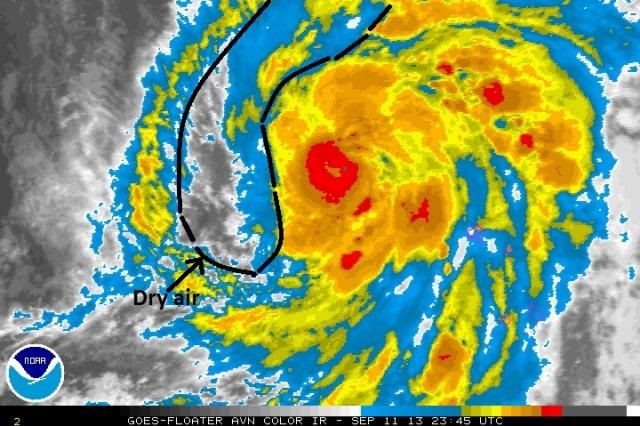
Haven't looked at long range this evening. But cat 2 is soooo close but dry air is really getting close to the core (oranges and reds). It's already flattening the west side of the core. (By flattening the west side I mean dry air is eroding the convection on the western side) Look:

Last edited by ozonepete on Wed Sep 11, 2013 8:09 pm, edited 1 time in total.
0 likes

-
hurricanes1234
- Category 5
- Posts: 2904
- Joined: Sat Jul 28, 2012 6:19 pm
- Location: Trinidad and Tobago
Re: ATL: HUMBERTO - Hurricane - Discussion
Best Track not issued as yet.
0 likes
PLEASE NOTE: With the exception of information from weather agencies that I may copy and paste here, my posts will NEVER be official, since I am NOT a meteorologist. They are solely my amateur opinion, and may or may not be accurate. Therefore, please DO NOT use them as official details, particularly when making important decisions. Thank you.
-
ozonepete
- Professional-Met
- Posts: 4743
- Joined: Mon Sep 07, 2009 3:23 pm
- Location: From Ozone Park, NYC / Now in Brooklyn, NY
Re:
RL3AO wrote:After extrapolating the center location, I measured embedded in black by 0.7 degrees which is T5.0
Love that you learned this. I'm very impressed.
0 likes
-
cycloneye

- Admin

- Posts: 139593
- Age: 67
- Joined: Thu Oct 10, 2002 10:54 am
- Location: San Juan, Puerto Rico
Re: ATL: HUMBERTO - Hurricane - Discussion
hurricanes1234 wrote:Best Track not issued as yet.
Stays at 75kts.
AL, 09, 2013091200, , BEST, 0, 185N, 289W, 75, 986, HU
0 likes
Visit the Caribbean-Central America Weather Thread where you can find at first post web cams,radars
and observations from Caribbean basin members Click Here
and observations from Caribbean basin members Click Here
-
TropicalAnalystwx13

- Category 5
- Posts: 2109
- Age: 26
- Joined: Tue Jul 19, 2011 8:20 pm
- Location: Wilmington, NC
- Contact:
Re: ATL: HUMBERTO - Hurricane - Discussion
cycloneye wrote:hurricanes1234 wrote:Best Track not issued as yet.
Stays at 75kts.
AL, 09, 2013091200, , BEST, 0, 185N, 289W, 75, 986, HU
A little low, in my opinion.
0 likes
-
hurricanes1234
- Category 5
- Posts: 2904
- Joined: Sat Jul 28, 2012 6:19 pm
- Location: Trinidad and Tobago
Re: ATL: HUMBERTO - Hurricane - Discussion
TropicalAnalystwx13 wrote:cycloneye wrote:hurricanes1234 wrote:Best Track not issued as yet.
Stays at 75kts.
AL, 09, 2013091200, , BEST, 0, 185N, 289W, 75, 986, HU
A little low, in my opinion.
Exactly, this storm has managed to develop a complete ring of convection around the eye, and it looks even better than this afternoon. I would assume they leave it at 75 knots, but Humberto looks like at least 80 knots. Just my opinion.
Personal Forecast Disclaimer: The posts in this forum are NOT official forecast and should not be used as such. They are just the opinion of the poster and may or may not be backed by sound meteorological data. They are NOT endorsed by any professional institution or storm2k.org. For official information, please refer to the NHC and NWS products.
0 likes
PLEASE NOTE: With the exception of information from weather agencies that I may copy and paste here, my posts will NEVER be official, since I am NOT a meteorologist. They are solely my amateur opinion, and may or may not be accurate. Therefore, please DO NOT use them as official details, particularly when making important decisions. Thank you.
-
hurricanes1234
- Category 5
- Posts: 2904
- Joined: Sat Jul 28, 2012 6:19 pm
- Location: Trinidad and Tobago
Re: ATL: HUMBERTO - Hurricane - Discussion
Oh, wait, the pressure dropped. My bad. 
AL, 09, 2013091200, , BEST, 0, 185N, 289W, 75, 982, HU,
AL, 09, 2013091200, , BEST, 0, 185N, 289W, 75, 982, HU,
0 likes
PLEASE NOTE: With the exception of information from weather agencies that I may copy and paste here, my posts will NEVER be official, since I am NOT a meteorologist. They are solely my amateur opinion, and may or may not be accurate. Therefore, please DO NOT use them as official details, particularly when making important decisions. Thank you.
-
CrazyC83
- Professional-Met
- Posts: 33398
- Joined: Tue Mar 07, 2006 11:57 pm
- Location: Deep South, for the first time!
Re: ATL: HUMBERTO - Hurricane - Discussion
hurricanes1234 wrote:Oh, wait, the pressure dropped. My bad.
AL, 09, 2013091200, , BEST, 0, 185N, 289W, 75, 982, HU,
Probably reflective of the larger size of the storm. Larger storms tend to have lower pressures, and 982mb is slightly above the Dvorak normal (980mb) for 75 kt.
0 likes
-
hurricanes1234
- Category 5
- Posts: 2904
- Joined: Sat Jul 28, 2012 6:19 pm
- Location: Trinidad and Tobago
Re:
CrazyC83 wrote:It looks more like a T5.0 to me as well. I'd have had it at 85 kt through the late afternoon and evening.
Yes, I strongly agree with this. Humberto has managed to develop a cloud-filled eye with a ring of deep convection completely around it. I would say 90 mph at the very least, but with the pressure drop, it now seems a tad more realistic.
The posts in this forum are NOT official forecast and should not be used as such. They are just the opinion of the poster and may or may not be backed by sound meteorological data. They are NOT endorsed by any professional institution or storm2k.org. For official information, please refer to the NHC and NWS products.
0 likes
PLEASE NOTE: With the exception of information from weather agencies that I may copy and paste here, my posts will NEVER be official, since I am NOT a meteorologist. They are solely my amateur opinion, and may or may not be accurate. Therefore, please DO NOT use them as official details, particularly when making important decisions. Thank you.
-
ozonepete
- Professional-Met
- Posts: 4743
- Joined: Mon Sep 07, 2009 3:23 pm
- Location: From Ozone Park, NYC / Now in Brooklyn, NY
Re: ATL: HUMBERTO - Hurricane - Discussion
Looks to me like it may be moving NNE in the last couple of hours, which I would think is a temporary jog. And that is actually good for avoiding the dry air. In the last few frames the core has been holding tight with nice convection and the dry air hasn't gotten in there.
0 likes
Who is online
Users browsing this forum: No registered users and 4 guests