ATL: INVEST 95L - Models
Moderator: S2k Moderators
-
stormlover2013
- Category 5

- Posts: 2312
- Joined: Thu Aug 22, 2013 12:06 pm
- Location: Lumberton, Texas
-
JtSmarts

- S2K Supporter

- Posts: 1422
- Age: 38
- Joined: Thu Jul 10, 2003 1:29 pm
- Location: Columbia, South Carolina
Re: ATL: INVEST 95L - Models
I know that has a very very low chance of happening (HWRF is best for entertainment only) , but it would surely get the board hopping if that scene played out.
0 likes
-
Portastorm

- Storm2k Moderator

- Posts: 9787
- Age: 61
- Joined: Fri Jul 11, 2003 9:16 am
- Location: South Austin, TX
- Contact:
Re: ATL: INVEST 95L - Models
stormlover2013 wrote:WOWWWW EURO ends with making a towards la!!!! central to sw la
Btw, thank you for updating your profile per my earlier request.
0 likes
Any forecasts under my name are to be taken with a grain of salt. Get your best forecasts from the National Weather Service and National Hurricane Center.
I'm a certified Advanced SKYWARN-trained spotter and am active on Twitter at @TravisCOSW, a social media partner of the NWS Austin-San Antonio office.
I'm a certified Advanced SKYWARN-trained spotter and am active on Twitter at @TravisCOSW, a social media partner of the NWS Austin-San Antonio office.
-
tolakram
- Admin

- Posts: 19172
- Age: 60
- Joined: Sun Aug 27, 2006 8:23 pm
- Location: Florence, KY (name is Mark)
Re: ATL: INVEST 95L - Models
The UKM run is updated as well, different solution but it ends up near the same place, but in 5 days.
http://ruc.noaa.gov/hfip/tcgen/

http://ruc.noaa.gov/hfip/tcgen/
0 likes
M a r k
- - - - -
Join us in chat: Storm2K Chatroom Invite. Android and IOS apps also available.
The posts in this forum are NOT official forecasts and should not be used as such. Posts are NOT endorsed by any professional institution or STORM2K.org. For official information and forecasts, please refer to NHC and NWS products.
-
Stormcenter
- S2K Supporter
- Posts: 6617
- Joined: Wed Sep 03, 2003 11:27 am
- Location: Houston, TX

-
tropicwatch

- Category 5
- Posts: 3205
- Age: 60
- Joined: Sat Jun 02, 2007 10:01 am
- Location: Panama City Florida
- Contact:
Re: ATL: INVEST 95L - Models
tolakram wrote:The UKM run is updated as well, different solution but it ends up near the same place, but in 5 days.
http://ruc.noaa.gov/hfip/tcgen/
Doesn't the EURO usually stay left of most of the other models?
0 likes
Tropicwatch
Agnes 72', Eloise 75, Elena 85', Kate 85', Charley 86', Florence 88', Beryl 94', Dean 95', Erin 95', Opal 95', Earl 98', Georges 98', Ivan 2004', Arlene 2005', Dennis 2005', Ida 2009' Debby 2012' Irma 2017' Michael 2018'
Agnes 72', Eloise 75, Elena 85', Kate 85', Charley 86', Florence 88', Beryl 94', Dean 95', Erin 95', Opal 95', Earl 98', Georges 98', Ivan 2004', Arlene 2005', Dennis 2005', Ida 2009' Debby 2012' Irma 2017' Michael 2018'
-
Wx_Warrior
- Category 5
- Posts: 2718
- Joined: Thu Aug 03, 2006 3:58 pm
- Location: Beaumont, TX

Re: ATL: INVEST 95L - Models
the EURO and CMC now look to be on the same page for now.....see that the 18Z BAMMS have come to their senses.... EURO gets this very near the coast of MX and it hangs out there for awhile...before heading north....
0 likes
Re: ATL: INVEST 95L - Models
Wx_Warrior wrote:Per some ^^^ Wasnt too "left" with Ingrid.
0 likes
Re: ATL: INVEST 95L - Models
it misses the front....EURO doesnt think it will be deep enough to pick it up...
0 likes
-
tolakram
- Admin
- Posts: 19172
- Age: 60
- Joined: Sun Aug 27, 2006 8:23 pm
- Location: Florence, KY (name is Mark)
Re: ATL: INVEST 95L - Models
Wx_Warrior wrote:Per some ^^^ Wasnt too "left" with Ingrid.
http://ruc.noaa.gov/hfip/tcgen/
You can visit the site I listed, select Ingrid for the storm to see the verification plots, then step back in days to see how the Euro did to actual. Most runs it was a little south of the actual landfall. Really no need to argue about it anymore.
0 likes
M a r k
- - - - -
Join us in chat: Storm2K Chatroom Invite. Android and IOS apps also available.
The posts in this forum are NOT official forecasts and should not be used as such. Posts are NOT endorsed by any professional institution or STORM2K.org. For official information and forecasts, please refer to NHC and NWS products.
- - - - -
Join us in chat: Storm2K Chatroom Invite. Android and IOS apps also available.
The posts in this forum are NOT official forecasts and should not be used as such. Posts are NOT endorsed by any professional institution or STORM2K.org. For official information and forecasts, please refer to NHC and NWS products.
-
tolakram
- Admin
- Posts: 19172
- Age: 60
- Joined: Sun Aug 27, 2006 8:23 pm
- Location: Florence, KY (name is Mark)
Re: ATL: INVEST 95L - Models
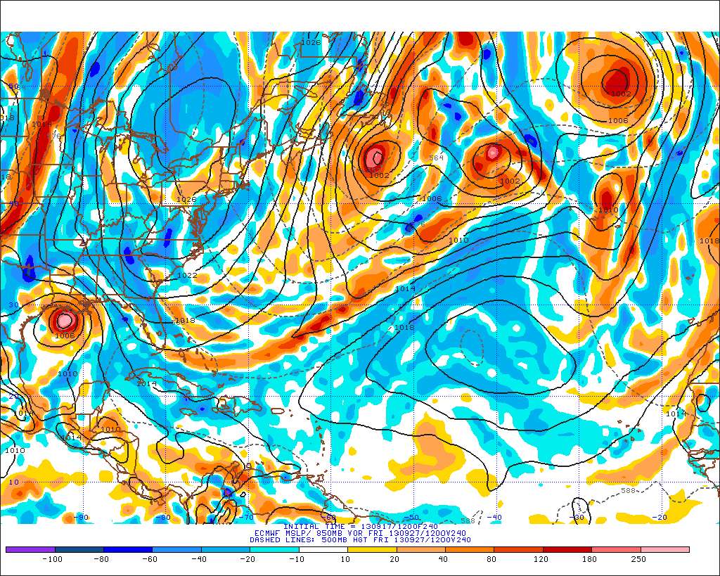
The Atlantic E-Wall has updated.
http://www.meteo.psu.edu/ewall/ECMWFTROPATL0.5_12z/ecmwfloop.html#picture
http://www.meteo.psu.edu/ewall/ECMWFTROPATL0.5_12z/ecmwfloop.html#picture
0 likes
M a r k
- - - - -
Join us in chat: Storm2K Chatroom Invite. Android and IOS apps also available.
The posts in this forum are NOT official forecasts and should not be used as such. Posts are NOT endorsed by any professional institution or STORM2K.org. For official information and forecasts, please refer to NHC and NWS products.
- - - - -
Join us in chat: Storm2K Chatroom Invite. Android and IOS apps also available.
The posts in this forum are NOT official forecasts and should not be used as such. Posts are NOT endorsed by any professional institution or STORM2K.org. For official information and forecasts, please refer to NHC and NWS products.
-
stormlover2013
- Category 5
- Posts: 2312
- Joined: Thu Aug 22, 2013 12:06 pm
- Location: Lumberton, Texas
Re: ATL: INVEST 95L - Models
I know its just one run of the euro, this is a tricky pattern!!
0 likes
-
CYCLONE MIKE
- Category 5
- Posts: 2183
- Joined: Tue Aug 31, 2004 6:04 pm
- Location: Gonzales, LA
Re: ATL: INVEST 95L - Models
tolakram wrote:The UKM run is updated as well, different solution but it ends up near the same place, but in 5 days.
http://ruc.noaa.gov/hfip/tcgen/
Now this and the euro has me a little more interested and I'm sure will be on our local weather at 6 as well. Obviously things will change 100x's over IF this even develops but since some take it far east to Florida and at the other end some still say mexico the north gulf looks like a safe bet for now. Now if the cmc shows it I know it will never happen
0 likes
This post is NOT AN OFFICIAL FORECAST and should not be used as such. It is just the opinion of the poster and may or may not be backed by sound meteorological data. It is NOT endorsed by any professional institution including storm2k.org. For Official Information please refer to the NHC and NWS products.

Re: ATL: INVEST 95L - Models
Yeah Euro might be a little slow on the pick up and thus gets leftover. A possibility no doubt. But if the system develops any intensity at all, I have to believe the trough will pick it up. Still am having a hard time thinking this system will get very strong - think upper level conditions will deteriorate with time.
0 likes
-
supercane4867
- Category 5
- Posts: 4966
- Joined: Wed Nov 14, 2012 10:43 am
Re: ATL: INVEST 95L - Models
12Z HWRF has Major Hurricane Jerry in the Gulf moving NE at day 5
*For Entertainment*

*For Entertainment*
0 likes
-
gatorcane

- S2K Supporter
- Posts: 23499
- Age: 46
- Joined: Sun Mar 13, 2005 3:54 pm
- Location: Boca Raton, FL
Here is the full loop of the HWRF:
http://moe.met.fsu.edu/cgi-bin/hwrftc2.cgi?time=2013091712-invest95l&field=Sea+Level+Pressure&hour=Animation
http://moe.met.fsu.edu/cgi-bin/hwrftc2.cgi?time=2013091712-invest95l&field=Sea+Level+Pressure&hour=Animation
0 likes
Who is online
Users browsing this forum: No registered users and 4 guests