WPAC: DAMREY - Typhoon

Moderator: S2k Moderators

Message
Author
User avatar
euro6208
Category 5
Category 5
Posts: 18547
Joined: Mon Mar 08, 2004 7:50 pm
Location: Guam

Re: WPAC: DAMREY - Severe Tropical Storm

#61 Postby euro6208 » Wed Aug 01, 2012 10:21 pm

Image

only 65 knots 1 min? i don't think so...Damrey is still rapidly intensifying as it nears china...


CI# /Pressure/ Vmax
5.3 / 943.6mb/ 97.2kt


Final T# Adj T# Raw T#
5.3 5.6 5.6

estimates are already at 95 knots due to its ever increasing symmetric eye....small storms tend to be stronger too...

i would place the intensity at a very conservative 100 knots category 3 strength.... :eek:


The posts in this forum are NOT official forecast and should not be used as such. They are just the opinion of the poster and may or may not be backed by sound meteorological data. They are NOT endorsed by any professional institution or storm2k.org. For official information, please refer to the JTWC and JMA products.
0 likes   
Remember, all of my post aren't official. For official warnings and discussions, Please refer to your local NWS products...

NWS for the Western Pacific

https://www.weather.gov/gum/

User avatar
euro6208
Category 5
Category 5
Posts: 18547
Joined: Mon Mar 08, 2004 7:50 pm
Location: Guam

Re: WPAC: DAMREY - Severe Tropical Storm

#62 Postby euro6208 » Wed Aug 01, 2012 10:25 pm

Image

better and better organized...
0 likes   
Remember, all of my post aren't official. For official warnings and discussions, Please refer to your local NWS products...

NWS for the Western Pacific

https://www.weather.gov/gum/

phwxenthusiast
Category 2
Category 2
Posts: 637
Joined: Wed Mar 24, 2010 3:10 am
Location: Holbrook, NY (Long Island)

Re: WPAC: DAMREY - Severe Tropical Storm

#63 Postby phwxenthusiast » Wed Aug 01, 2012 10:59 pm

euro6208 wrote:
only 65 knots 1 min? i don't think so...Damrey is still rapidly intensifying as it nears china...

estimates are already at 95 knots due to its ever increasing symmetric eye....small storms tend to be stronger too...

i would place the intensity at a very conservative 100 knots category 3 strength.... :eek:

The posts in this forum are NOT official forecast and should not be used as such. They are just the opinion of the poster and may or may not be backed by sound meteorological data. They are NOT endorsed by any professional institution or storm2k.org. For official information, please refer to the JTWC and JMA products.


yup fully agree with you although i would place the intensity at around 85kts... yes the convection has warmed although the symmetrical eye, really good microwave representation, and high ADT and SATCON estimates, this system is clearly stronger than what both JTWC and JMA are saying; especially JMA which is currently assessing Damrey as a paltry 50kt system lols!!

Personal Forecast Disclaimer:
The posts in this forum are NOT official forecast and should not be used as such. They are just the opinion of the poster and may or may not be backed by sound meteorological data. They are NOT endorsed by any professional institution or storm2k.org. For official information, please refer to the NHC and NWS products.
0 likes   

User avatar
euro6208
Category 5
Category 5
Posts: 18547
Joined: Mon Mar 08, 2004 7:50 pm
Location: Guam

Re: WPAC: DAMREY - Severe Tropical Storm

#64 Postby euro6208 » Wed Aug 01, 2012 11:38 pm

Image

CI# /Pressure/ Vmax
5.4 / 941.6mb/ 99.6kt


Final T# Adj T# Raw T#
5.4 5.6 5.6

increasing...
0 likes   
Remember, all of my post aren't official. For official warnings and discussions, Please refer to your local NWS products...

NWS for the Western Pacific

https://www.weather.gov/gum/

Meow

#65 Postby Meow » Thu Aug 02, 2012 1:29 am

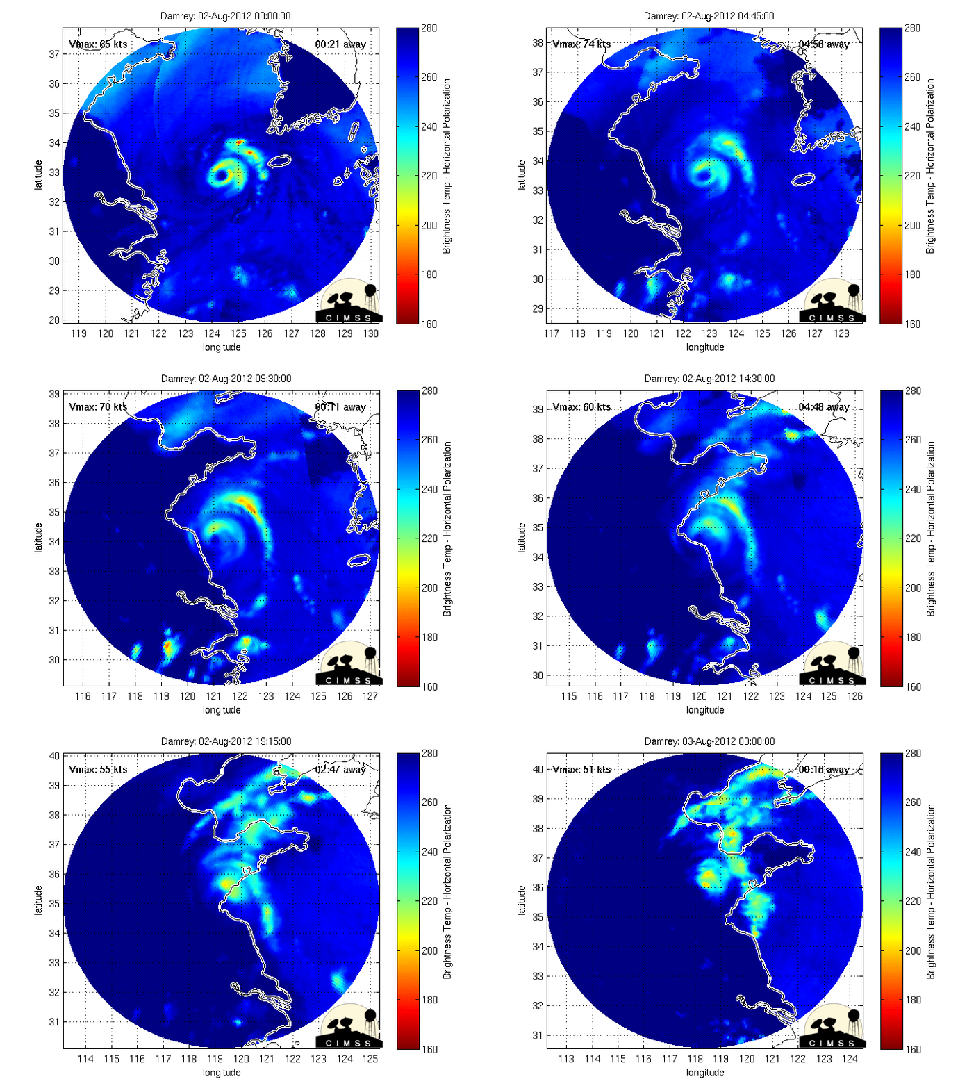
Incredibly beautiful...

Image

Image

Image
0 likes   

Meow

Re: WPAC: DAMREY - Severe Tropical Storm

#66 Postby Meow » Thu Aug 02, 2012 1:59 am

JMA: 60 knots

Image

STS 1210 (DAMREY)
Issued at 06:55 UTC, 2 August 2012

<Analyses at 02/06 UTC>
Scale -
Intensity -
Center position N33°50'(33.8°)
E122°10'(122.2°)
Direction and speed of movement WNW 35km/h(20kt)
Central pressure 970hPa
Maximum wind speed near the center 30m/s(60kt)
Maximum wind gust speed 45m/s(85kt)
Area of 50kt winds or more ALL70km(40NM)
Area of 30kt winds or more ALL330km(180NM)

<Forecast for 02/18 UTC>
Intensity -
Center position of probability circle N34°55'(34.9°)
E118°30'(118.5°)
Direction and speed of movement WNW 30km/h(16kt)
Central pressure 980hPa
Maximum sustained wind speed 25m/s(50kt)
Maximum wind gust speed 35m/s(70kt)
Radius of probability circle 90km(50NM)

<Forecast for 03/06 UTC>
Intensity -
TD
Center position of probability circle N36°30'(36.5°)
E116°30'(116.5°)
Direction and speed of movement NW 20km/h(11kt)
Central pressure 998hPa
Radius of probability circle 140km(75NM)
0 likes   

Chickenzilla
Tropical Storm
Tropical Storm
Posts: 109
Joined: Wed Oct 19, 2011 7:31 am
Location: Croatia (Southeast Europe)

#67 Postby Chickenzilla » Thu Aug 02, 2012 3:16 am

Damrey is a beautiful storm. I'd place the intensity at Category 3 strength if the convection was any deeer. :darrow:
Image
0 likes   

phwxenthusiast
Category 2
Category 2
Posts: 637
Joined: Wed Mar 24, 2010 3:10 am
Location: Holbrook, NY (Long Island)

#68 Postby phwxenthusiast » Thu Aug 02, 2012 5:11 am

It is now about to make landfall in Jiangsu Province... first Red Alert this year now issued by CMA... :eek:

Image
0 likes   

Meow

Re: WPAC: DAMREY - Typhoon

#69 Postby Meow » Thu Aug 02, 2012 6:07 am

The JMA upgraded Damrey to a typhoon at 09Z.

Image

TY 1210 (DAMREY)
Issued at 10:00 UTC, 2 August 2012

<Analyses at 02/09 UTC>
Scale -
Intensity Strong
Center position N34°10'(34.2°)
E121°25'(121.4°)
Direction and speed of movement WNW 35km/h(20kt)
Central pressure 970hPa
Maximum wind speed near the center 35m/s(70kt)
Maximum wind gust speed 50m/s(100kt)
Area of 50kt winds or more ALL90km(50NM)
Area of 30kt winds or more ALL330km(180NM)

<Forecast for 02/21 UTC>
Intensity -
Center position of probability circle N35°50'(35.8°)
E118°00'(118.0°)
Direction and speed of movement WNW 30km/h(16kt)
Central pressure 985hPa
Maximum sustained wind speed 23m/s(45kt)
Maximum wind gust speed 35m/s(65kt)
Radius of probability circle 90km(50NM)

<Forecast for 03/09 UTC>
Intensity -
TD
Center position of probability circle N37°20'(37.3°)
E116°25'(116.4°)
Direction and speed of movement NW 20km/h(10kt)
Central pressure 998hPa
Radius of probability circle 130km(70NM)
0 likes   

phwxenthusiast
Category 2
Category 2
Posts: 637
Joined: Wed Mar 24, 2010 3:10 am
Location: Holbrook, NY (Long Island)

#70 Postby phwxenthusiast » Thu Aug 02, 2012 6:32 am

Thank you JMA!!! Rarely do they upgrade systems at 09z and they actually put it from 50kt to 70kt this time; my faith to them is restored!! 8-)
0 likes   

Meow

Re:

#71 Postby Meow » Thu Aug 02, 2012 7:47 am

phwxenthusiast wrote:Thank you JMA!!! Rarely do they upgrade systems at 09z and they actually put it from 50kt to 70kt this time; my faith to them is restored!! 8-)

It was 60 knots at 06Z. :ggreen:
0 likes   

User avatar
yulou
Tropical Depression
Tropical Depression
Posts: 99
Age: 26
Joined: Sat Nov 20, 2010 8:19 am
Location: Houston,TX
Contact:

#72 Postby yulou » Thu Aug 02, 2012 10:15 am

Just landfall at Chenjiagang Town,Xiangshui County,Yancheng City,Jiangsu Province at 0130Z
Image
Damrey is the strongest typhoon of Jiangsu since 1949.
0 likes   
Chinese.
Houston, TX.

Bilis(0604) Saomai(0608) Goni(0907)

User avatar
euro6208
Category 5
Category 5
Posts: 18547
Joined: Mon Mar 08, 2004 7:50 pm
Location: Guam

Re: Re:

#73 Postby euro6208 » Thu Aug 02, 2012 10:51 am

Meow wrote:
phwxenthusiast wrote:Thank you JMA!!! Rarely do they upgrade systems at 09z and they actually put it from 50kt to 70kt this time; my faith to them is restored!! 8-)

It was 60 knots at 06Z. :ggreen:


over 24 hours late :roll:
0 likes   
Remember, all of my post aren't official. For official warnings and discussions, Please refer to your local NWS products...

NWS for the Western Pacific

https://www.weather.gov/gum/

User avatar
euro6208
Category 5
Category 5
Posts: 18547
Joined: Mon Mar 08, 2004 7:50 pm
Location: Guam

Re: WPAC: DAMREY - Typhoon

#74 Postby euro6208 » Thu Aug 02, 2012 10:55 am

WTPN32 PGTW 021500
MSGID/GENADMIN/JOINT TYPHOON WRNCEN PEARL HARBOR HI//
SUBJ/TROPICAL CYCLONE WARNING//
RMKS/
1. TYPHOON 11W (DAMREY) WARNING NR 020
02 ACTIVE TROPICAL CYCLONES IN NORTHWESTPAC
MAX SUSTAINED WINDS BASED ON ONE-MINUTE AVERAGE
WIND RADII VALID OVER OPEN WATER ONLY
---
WARNING POSITION:
021200Z --- NEAR 34.6N 120.2E
MOVEMENT PAST SIX HOURS - 295 DEGREES AT 18 KTS
POSITION ACCURATE TO WITHIN 025 NM
POSITION BASED ON CENTER LOCATED BY SATELLITE
PRESENT WIND DISTRIBUTION:
MAX SUSTAINED WINDS - 065 KT, GUSTS 080 KT
WIND RADII VALID OVER OPEN WATER ONLY
RADIUS OF 050 KT WINDS - 025 NM NORTHEAST QUADRANT
025 NM SOUTHEAST QUADRANT
025 NM SOUTHWEST QUADRANT
025 NM NORTHWEST QUADRANT
RADIUS OF 034 KT WINDS - 090 NM NORTHEAST QUADRANT
070 NM SOUTHEAST QUADRANT
100 NM SOUTHWEST QUADRANT
110 NM NORTHWEST QUADRANT
REPEAT POSIT: 34.6N 120.2E
---
FORECASTS:
12 HRS, VALID AT:
030000Z --- 35.6N 117.8E
MAX SUSTAINED WINDS - 045 KT, GUSTS 055 KT
WIND RADII VALID OVER OPEN WATER ONLY
VECTOR TO 24 HR POSIT: 300 DEG/ 05 KTS
---
24 HRS, VALID AT:
031200Z --- 36.1N 116.7E
MAX SUSTAINED WINDS - 030 KT, GUSTS 040 KT
WIND RADII VALID OVER OPEN WATER ONLY
DISSIPATING AS A SIGNIFICANT TROPICAL CYCLONE OVER LAND
VECTOR TO 36 HR POSIT: 335 DEG/ 04 KTS
---
36 HRS, VALID AT:
040000Z --- 36.9N 116.2E
MAX SUSTAINED WINDS - 020 KT, GUSTS 030 KT
WIND RADII VALID OVER OPEN WATER ONLY
DISSIPATED AS A SIGNIFICANT TROPICAL CYCLONE OVER LAND
---
REMARKS:
021500Z POSITION NEAR 34.9N 119.6E.
TYPHOON 11W (DAMREY), LOCATED APPROXIMATELY 365 NM SOUTH-SOUTHEAST OF
BEIJING, CHINA, HAS TRACKED NORTHWESTWARD AT 21 KNOTS OVER THE PAST
SIX HOURS. MAXIMUM SIGNIFICANT WAVE HEIGHT AT 021200Z IS 28 FEET.
NEXT WARNINGS AT 022100Z. REFER TO TROPICAL STORM 10W (SAOLA)
WARNINGS (WTPN31 PGTW) FOR SIX-HOURLY UPDATES. //
NNNN

Image

WDPN32 PGTW 021500
MSGID/GENADMIN/JOINT TYPHOON WRNCEN PEARL HARBOR HI//
SUBJ/PROGNOSTIC REASONING FOR TYPHOON 11W (DAMREY) WARNING NR 20//
RMKS//
1. FOR METEOROLOGISTS.
2. 6 HOUR SUMMARY AND ANALYSIS.
TYPHOON (TY) 11W (DAMREY), LOCATED APPROXIMATELY 365 NM
SOUTH-SOUTHEAST OF BEIJING, CHINA, HAS TRACKED NORTHWESTWARD AT 21
KNOTS OVER THE PAST SIX HOURS. ANIMATED ENHANCED INFRARED (EIR)
SATELLITE IMAGERY SHOWS THE SYSTEM HAS MAINTAINED A 15-NM RAGGED EYE
AS CONVECTIVE TOPS HAVE WARMED, AN INDICATION OF WEAKENING. THE
CURRENT POSITION IS BASED ON THE ANIMATED EIR IMAGERY WITH HIGH
CONFIDENCE. THE CURRENT INTENSITY IS AVERAGED FROM DVORAK ESTIMATES
FROM PGTW AND KNES. UPPER-LEVEL ANALYSIS INDICATES THE SYSTEM IS 10
DEGREES SOUTH OF A RIDGE AXIS IN AN AREA OF LIGHT TO MODERATE (10-20
KNOT) EASTERLY VERTICAL WIND SHEAR. THE CYCLONE IS TRACKING ALONG THE
SOUTHERN PERIPHERY OF A DEEP-LAYERED SUBTROPICAL RIDGE (STR) ANCHORED
OVER KYUSHU, JAPAN.
3. FORECAST REASONING.
A. THERE IS NO SIGNIFICANT CHANGE TO THE FORECAST PHILOSOPHY
FROM THE PREVIOUS PROGNOSTIC REASONING.
B. TY 11W IS EXPECTED TO MAKE LANDFALL IN THE NEXT FEW HOURS OVER
EASTERN CHINA THEN WILL RAPIDLY DECAY DUE TO FRICTIONAL EFFECTS FROM
THE RUGGED TERRAIN. TY DAMREY WILL DISSIPATE AS A SIGNIFICANT
TROPICAL CYCLONE OVER LAND BY TAU 36. MODEL GUIDANCE WIDELY DIVERGE
WITH MOST MODELS SHOWING AN UNLIKELY TRACK INTO THE STR. ECMWF IS THE
SOLE LEFT OUTLIER. THIS TRACK FORECAST IS JUST TO THE LEFT OF
CONSENSUS. THERE IS LOW CONFIDENCE IN THE TRACK FORECAST DUE TO THE
BIG DISPARITY IN THE MODEL AIDS. //
NNNN
0 likes   
Remember, all of my post aren't official. For official warnings and discussions, Please refer to your local NWS products...

NWS for the Western Pacific

https://www.weather.gov/gum/

User avatar
euro6208
Category 5
Category 5
Posts: 18547
Joined: Mon Mar 08, 2004 7:50 pm
Location: Guam

Re: WPAC: DAMREY - Typhoon

#75 Postby euro6208 » Thu Aug 02, 2012 11:20 am

Image


CI# /Pressure/ Vmax
4.7 / 954.3mb/ 82.2kt


Final T# Adj T# Raw T#
4.3 4.2 3.2
0 likes   
Remember, all of my post aren't official. For official warnings and discussions, Please refer to your local NWS products...

NWS for the Western Pacific

https://www.weather.gov/gum/

User avatar
euro6208
Category 5
Category 5
Posts: 18547
Joined: Mon Mar 08, 2004 7:50 pm
Location: Guam

Re: WPAC: DAMREY - Typhoon

#76 Postby euro6208 » Thu Aug 02, 2012 11:49 am

Image

Image

a recap of this incredible typhoon!looks like both storms might need some adjustment in postseason!
0 likes   
Remember, all of my post aren't official. For official warnings and discussions, Please refer to your local NWS products...

NWS for the Western Pacific

https://www.weather.gov/gum/

Meow

#77 Postby Meow » Thu Aug 02, 2012 2:11 pm

How can Damrey still maintain its typhoon strength inland?

Image

TY 1210 (DAMREY)
Issued at 19:05 UTC, 2 August 2012

<Analyses at 02/18 UTC>
Scale -
Intensity Strong
Center position N34°55'(34.9°)
E119°25'(119.4°)
Direction and speed of movement WNW 15km/h(9kt)
Central pressure 975hPa
Maximum wind speed near the center 35m/s(65kt)
Maximum wind gust speed 50m/s(95kt)
Area of 50kt winds or more ALL90km(50NM)
Area of 30kt winds or more ALL330km(180NM)

<Forecast for 03/06 UTC>
Intensity -
Center position of probability circle N36°35'(36.6°)
E117°50'(117.8°)
Direction and speed of movement NW 20km/h(11kt)
Central pressure 990hPa
Maximum sustained wind speed 20m/s(40kt)
Maximum wind gust speed 30m/s(60kt)
Radius of probability circle 90km(50NM)

<Forecast for 03/18 UTC>
Intensity -
TD
Center position of probability circle N38°25'(38.4°)
E116°55'(116.9°)
Direction and speed of movement NNW 20km/h(10kt)
Central pressure 998hPa
Radius of probability circle 130km(70NM)
0 likes   

phwxenthusiast
Category 2
Category 2
Posts: 637
Joined: Wed Mar 24, 2010 3:10 am
Location: Holbrook, NY (Long Island)

#78 Postby phwxenthusiast » Thu Aug 02, 2012 11:46 pm

Damrey's core is still largely intact, amazingly... it is now pushing NW-ward towards Binzhou...

Image

Radar from CMA
0 likes   

User avatar
yulou
Tropical Depression
Tropical Depression
Posts: 99
Age: 26
Joined: Sat Nov 20, 2010 8:19 am
Location: Houston,TX
Contact:

#79 Postby yulou » Sun Aug 05, 2012 11:24 am

Measured Wind
_____________________________GUST 2-min 10-min(m/s)
Xilian Island(the elevation is 22m) 44.4 38.0 36.2
Mount Beigu of Xugou(Lianyungang) 44.4
Dagui Jian 41.3
Kaishan Island 41.1

it seems that it was C2 when it landfell at Yancheng
0 likes   
Chinese.
Houston, TX.

Bilis(0604) Saomai(0608) Goni(0907)

Meow

Re: WPAC: DAMREY - Typhoon

#80 Postby Meow » Wed May 22, 2013 8:38 pm

JMA: 70kt
JTWC: 80kt

In RSMC best track data, Damrey became a typhoon 9 hours earlier.
0 likes   


Return to “2013”

Who is online

Users browsing this forum: No registered users and 110 guests