
AN AREA OF CONVECTION HAS PERSISTED NEAR 5.3N 136.9E,
APPROXIMATELY 185 NM SOUTHEAST OF PALAU. ANIMATED MULTISPECTRAL
SATELLITE IMAGERY SHOWS A BROAD, ELONGATED LOW LEVEL CIRCULATION
CENTER (LLCC) WITH SPORADIC CONVECTION. A RECENT 170013Z ASCAT PASS
MISSED THE CENTRAL PORTIONS OF THE LLCC, BUT DOES INDICATE THE WINDS
ALONG THE WESTERN PERIPHERY ARE BETWEEN 10 AND 15 KNOTS.
ADDITIONALLY, IT INDICATES STRONGER GRADIENT INDUCED WINDS ARE
LOCATED TO THE NORTH OF THE LLCC AND ARE HELPING TO FUEL RECENT
CONVECTIVE ACTIVITY ALONG THE NORTHERN PERIPHERY OF THE LLCC. UPPER
LEVEL ANALYSIS INDICATES THE LLCC IS LOCATED TO THE SOUTH OF A DEEP
LAYERED SUBTROPICAL RIDGE WHICH IS CREATING MODERATE LEVELS OF
DIVERGENCE ALOFT, IN ADDITION TO LOW TO MODERATE LEVELS OF VERTICAL
WIND SHEAR (10 TO 20 KNOTS). SEA SURFACE TEMPERATURES IN THE
VICINITY OF THE LLCC ARE BETWEEN 28 AND 30 DEGREES CELSIUS.
OBSERVATIONS AT KOROR, PALAU SHOW A ONE MILLIBAR PRESSURE FALL OVER
THE PAST 24 HOURS, WITH THE CURRENT SEA LEVEL PRESSURE AT 1005 MB.
MAXIMUM SUSTAINED SURFACE WINDS ARE ESTIMATED AT 10 TO 15 KNOTS.
MINIMUM SEA LEVEL PRESSURE IS ESTIMATED TO BE NEAR 1004 MB. THE
POTENTIAL FOR THE DEVELOPMENT OF A SIGNIFICANT TROPICAL CYCLONE
WITHIN THE NEXT 24 HOURS IS LOW.
WPAC: Shanshan - Remnants
Moderator: S2k Moderators
Re: WPAC: INVEST 98W
0 likes
Remember, all of my post aren't official. For official warnings and discussions, Please refer to your local NWS products...
NWS for the Western Pacific
https://www.weather.gov/gum/
NWS for the Western Pacific
https://www.weather.gov/gum/
Re: WPAC: INVEST 98W
Since 1945, only 14 february tropical cyclones have been observed...
Strongest: Typhoon Nancy (1970) - Category 4 120 knots 949mb
1953 1 Typhoon #2 18-25 FEB 100 - 3
1959 1 Tropical Storm #1 27 FEB- 1 MAR 50
1961 2 Tropical Storm #2 27 FEB- 1 MAR 40
1962 1 Tropical Storm #1 2- 6 FEB 45 - -
1965 3 Tropical Storm #3 14-17 FEB 45 - -
4 Tropical Storm #4 18-19 FEB 40 - -
1967 1 Tropical Storm #1 4- 7 FEB 40 - -
1970 1 Typhoon Nancy 20-27 FEB 120 - 4
1976 1 Typhoon #1 26 JAN- 2 FEB 80 - 1
2 Tropical Storm #2 25 FEB- 3 MAR 35 - -
1986 1 Typhoon #1 1- 6 FEB 85 - 2
1993 1 Subtropical Storm #1 27 FEB- 2 MAR 25 - -
2004 1 Tropical Storm 01W 11-16 FEB 35 -
2012 1 Tropical Depression ONE 17-17 FEB 25 -
0 likes
Remember, all of my post aren't official. For official warnings and discussions, Please refer to your local NWS products...
NWS for the Western Pacific
https://www.weather.gov/gum/
NWS for the Western Pacific
https://www.weather.gov/gum/
-
xtyphooncyclonex

- Category 5

- Posts: 3688
- Age: 22
- Joined: Sat Dec 08, 2012 9:07 am
- Location: Cebu City
- Contact:
98W now has better convective activity.
PAGASA's advisory as of 5 p.m.,
At 2:00 pm today, a Low Pressure Area (LPA) was estimated based on all available data at 1,210 km East of Southern Mindanao (6.0°N, 138.0°E). Northeast Monsoon affecting Luzon.
The system looks a bit like Sonamu. Sheared system but shear over the Philippines is decreasing.
My track (in words): West runner going to the south of Palau. Landfall near Bislig in Surigao del Sur. Then turns slightly WNW towards Southern Bohol, Cebu then to the south of Bacolod City as it shifts its direction back to West then exits Visayas. Makes another landfall near Puerto Princesa, Palawan. Exits the Philippine Area of Responsibility. Stalls for hours up to 2 days in the South China Sea. Makes landfall in Ho Chi Minh City, Vietnam then dissipates.
My peak intensity: 85 km/h - 990-995 hPa - Tropical Storm.
0 likes
REMINDER: My opinions that I, or any other NON Pro-Met in this forum, are unofficial. Please do not take my opinions as an official forecast and warning. I am NOT a meteorologist. Following my forecasts blindly may lead to false alarm, danger and risk if official forecasts from agencies are ignored.
-
mrbagyo

- Category 5
- Posts: 3614
- Age: 31
- Joined: Thu Apr 12, 2012 9:18 am
- Location: 14.13N 120.98E
- Contact:
Re: WPAC: INVEST 98W
tropical cyclone in February is indeed kinda rare, I just checked an archive dating back to 14th century of storms in WPAC.. and found very few that formed in February..
0 likes
The posts in this forum are NOT official forecast and should not be used as such. They are just the opinion of the poster and may or may not be backed by sound meteorological data. They are NOT endorsed by any professional institution or storm2k.org. For official information, please refer to RSMC, NHC and NWS products.
Re: WPAC: INVEST 98W
EURO barely develops this...either it stays as an area of low pressure which i think is most likely or gets upgraded to a TD before landfall...
0 likes
Remember, all of my post aren't official. For official warnings and discussions, Please refer to your local NWS products...
NWS for the Western Pacific
https://www.weather.gov/gum/
NWS for the Western Pacific
https://www.weather.gov/gum/
-
Meow
Re: WPAC: INVEST 98W
euro6208 wrote:Since 1945, only 14 february tropical cyclones have been observed...
How can you ignore Mitag forming at 12Z on 28 February 2002?
JMA: 95kt 930hPa
JTWC: 140kt 898hPa (?)
0 likes
Re: WPAC: INVEST 98W
Meow wrote:euro6208 wrote:Since 1945, only 14 february tropical cyclones have been observed...
How can you ignore Mitag forming at 12Z on 28 February 2002?
JMA: 95kt 930hPa
JTWC: 140kt 898hPa (?)
oh i completely forgot about him... so make that 15 TC ...possibly the earliest category 5 on record so early in a season but our records only go back to 1945...christened as a TD on the 26th, TS on the 27th of Feb and a Category 5 on Mar 5...a record breaker...
0 likes
Remember, all of my post aren't official. For official warnings and discussions, Please refer to your local NWS products...
NWS for the Western Pacific
https://www.weather.gov/gum/
NWS for the Western Pacific
https://www.weather.gov/gum/
Re: WPAC: INVEST 98W

the philippines will surely get soaked whether or not this develops...
0 likes
Remember, all of my post aren't official. For official warnings and discussions, Please refer to your local NWS products...
NWS for the Western Pacific
https://www.weather.gov/gum/
NWS for the Western Pacific
https://www.weather.gov/gum/
-
Meow
Re: WPAC: INVEST 98W
Since 06Z, it has been a tropical depression by JMA.

WWJP25 RJTD 180600
WARNING AND SUMMARY 180600.
...
SUMMARY.
TROPICAL DEPRESSION 1004 HPA AT 05N 133E WEST SLOWLY.
...
JAPAN METEOROLOGICAL AGENCY.=
ECMWF supports this as a tropical storm in two days.

WWJP25 RJTD 180600
WARNING AND SUMMARY 180600.
...
SUMMARY.
TROPICAL DEPRESSION 1004 HPA AT 05N 133E WEST SLOWLY.
...
JAPAN METEOROLOGICAL AGENCY.=
ECMWF supports this as a tropical storm in two days.
0 likes
-
stormstrike
- Tropical Storm

- Posts: 159
- Joined: Thu Nov 29, 2012 12:37 am
Re: WPAC: INVEST 98W
Multi-model 00z run..

Euro Model
(this is for Wed 00z.. look.there's a closed system there.looks like a minimal tropical storm)

JMA
WWJP25 RJTD 180600
WARNING AND SUMMARY 180600.
WARNING VALID 190600.
WARNING IS UPDATED EVERY 6 HOURS.
STORM WARNING.
...
TROPICAL DEPRESSION 1004 HPA AT 05N 133E WEST SLOWLY.
...
JAPAN METEOROLOGICAL AGENCY.=
JTWC
THE AREA OF CONVECTION PREVIOUSLY LOCATED NEAR 5.3N
136.9E, IS NOW LOCATED NEAR 5.7N 131.8E, APPROXIMATELY 195 NM WEST-
SOUTHWEST OF PALAU. ANIMATED MULTISPECTRAL SATELLITE IMAGERY SHOWS
AN IMPROVING LOW LEVEL CIRCULATION CENTER (LLCC) WITH WEAKLY DEFINED
FORMATIVE BANDS OF CONVECTION. A RECENT 180038Z ASCAT PASS INDICATED
IMPROVEMENT IN THE LOW LEVEL STRUCTURE, WITH 15 TO 20 KNOT WINDS
ALONG THE NORTHERN PERIPHERY. UPPER LEVEL ANALYSIS INDICATES THE
LLCC REMAINS TO THE SOUTH OF A DEEP LAYERED SUBTROPICAL RIDGE WHICH
IS CREATING MODERATE LEVELS OF DIVERGENCE ALOFT, IN ADDITION TO LOW
TO MODERATE LEVELS OF VERTICAL WIND SHEAR (10 TO 20 KNOTS). SEA
SURFACE TEMPERATURES IN THE VICINITY OF THE LLCC ARE BETWEEN 28 AND
30 DEGREES CELSIUS. MAXIMUM SUSTAINED SURFACE WINDS ARE ESTIMATED AT
15 TO 20 KNOTS. MINIMUM SEA LEVEL PRESSURE IS ESTIMATED TO BE NEAR
1004 MB. BASED ON THE IMPROVING LLCC STRUCTURE, THE POTENTIAL FOR
THE DEVELOPMENT OF A SIGNIFICANT TROPICAL CYCLONE WITHIN THE NEXT 24
HOURS IS UPGRADED TO MEDIUM.
PAGASA
(no track as of this writing.. )
)
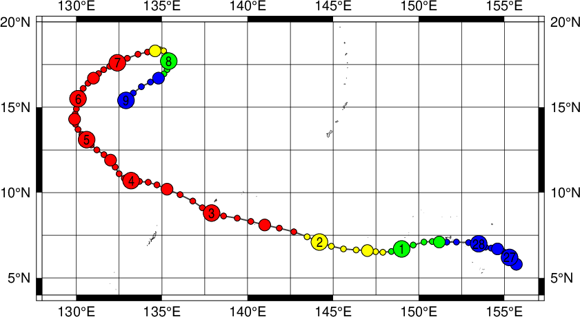
At 4:00 p.m. today, the center of Tropical Depression "CRISING" was estimated based on all available data at 750 km east of General Santos City (5.1°N, 132.3°E) with maximum sustained winds of 45 kph near the center. It is forecast to move west northwest at 19 kph.

Euro Model
(this is for Wed 00z.. look.there's a closed system there.looks like a minimal tropical storm)

JMA
WWJP25 RJTD 180600
WARNING AND SUMMARY 180600.
WARNING VALID 190600.
WARNING IS UPDATED EVERY 6 HOURS.
STORM WARNING.
...
TROPICAL DEPRESSION 1004 HPA AT 05N 133E WEST SLOWLY.
...
JAPAN METEOROLOGICAL AGENCY.=
JTWC
THE AREA OF CONVECTION PREVIOUSLY LOCATED NEAR 5.3N
136.9E, IS NOW LOCATED NEAR 5.7N 131.8E, APPROXIMATELY 195 NM WEST-
SOUTHWEST OF PALAU. ANIMATED MULTISPECTRAL SATELLITE IMAGERY SHOWS
AN IMPROVING LOW LEVEL CIRCULATION CENTER (LLCC) WITH WEAKLY DEFINED
FORMATIVE BANDS OF CONVECTION. A RECENT 180038Z ASCAT PASS INDICATED
IMPROVEMENT IN THE LOW LEVEL STRUCTURE, WITH 15 TO 20 KNOT WINDS
ALONG THE NORTHERN PERIPHERY. UPPER LEVEL ANALYSIS INDICATES THE
LLCC REMAINS TO THE SOUTH OF A DEEP LAYERED SUBTROPICAL RIDGE WHICH
IS CREATING MODERATE LEVELS OF DIVERGENCE ALOFT, IN ADDITION TO LOW
TO MODERATE LEVELS OF VERTICAL WIND SHEAR (10 TO 20 KNOTS). SEA
SURFACE TEMPERATURES IN THE VICINITY OF THE LLCC ARE BETWEEN 28 AND
30 DEGREES CELSIUS. MAXIMUM SUSTAINED SURFACE WINDS ARE ESTIMATED AT
15 TO 20 KNOTS. MINIMUM SEA LEVEL PRESSURE IS ESTIMATED TO BE NEAR
1004 MB. BASED ON THE IMPROVING LLCC STRUCTURE, THE POTENTIAL FOR
THE DEVELOPMENT OF A SIGNIFICANT TROPICAL CYCLONE WITHIN THE NEXT 24
HOURS IS UPGRADED TO MEDIUM.
PAGASA
(no track as of this writing..
At 4:00 p.m. today, the center of Tropical Depression "CRISING" was estimated based on all available data at 750 km east of General Santos City (5.1°N, 132.3°E) with maximum sustained winds of 45 kph near the center. It is forecast to move west northwest at 19 kph.
0 likes
-
stormstrike
- Tropical Storm
- Posts: 159
- Joined: Thu Nov 29, 2012 12:37 am
Re: WPAC: INVEST 98W
Latest wind swath forecast for 98W... weird that it's more concentrated way north of the system..


Almost the same for Euro model..

Even supported by TRMM Flood Forecast...

This is good news for Bopha-stricken Mindanao, if this goes through..


Almost the same for Euro model..

Even supported by TRMM Flood Forecast...

This is good news for Bopha-stricken Mindanao, if this goes through..
0 likes
-
mrbagyo
- Category 5
- Posts: 3614
- Age: 31
- Joined: Thu Apr 12, 2012 9:18 am
- Location: 14.13N 120.98E
- Contact:
Re: WPAC: INVEST 98W

here is the forecast track from PAGASA
0 likes
The posts in this forum are NOT official forecast and should not be used as such. They are just the opinion of the poster and may or may not be backed by sound meteorological data. They are NOT endorsed by any professional institution or storm2k.org. For official information, please refer to RSMC, NHC and NWS products.
-
RobWESTPACWX
- WestPACMet

- Posts: 1616
- Joined: Fri Sep 17, 2010 2:26 am
- Location: Tokyo, Japan
- Contact:
Re: WPAC: JMA TD (PAGASA TD Crising)
Even on Tuesday this will still be lingering, its persistence will be the dangerous aspect of it.

Uploaded with ImageShack.us

Uploaded with ImageShack.us
0 likes
Satellites, Charts and Forecasting tools for East Asia at WESTERNPACIFICWEATHER.COM
-
RobWESTPACWX
- WestPACMet
- Posts: 1616
- Joined: Fri Sep 17, 2010 2:26 am
- Location: Tokyo, Japan
- Contact:
-
dexterlabio
- Category 5
- Posts: 3406
- Joined: Sat Oct 24, 2009 11:50 pm
Re: WPAC: JMA TD (PAGASA TD Crising)
I actually hope this will get named as a TS as long as the rains won't be anomalous and stay as minimal. Just for the sake of having a named February TC.  For the Philippines, this is already the 3rd as early as Feb, and it seems that the A-Z name list will be completed before 2013 ends..of course depending on how active the heart of the season will be...
I'm worried for those people in Mindanao though..Same dilemma all over again.
I'm worried for those people in Mindanao though..Same dilemma all over again.
0 likes
Personal Forecast Disclaimer:
The posts in this forum are NOT official forecast and should not be used as such. They are just the opinion of the poster and may or may not be backed by sound meteorological data. They are NOT endorsed by any professional institution or storm2k.org. For official information, please refer to the NHC and NWS products.
The posts in this forum are NOT official forecast and should not be used as such. They are just the opinion of the poster and may or may not be backed by sound meteorological data. They are NOT endorsed by any professional institution or storm2k.org. For official information, please refer to the NHC and NWS products.
-
RobWESTPACWX
- WestPACMet
- Posts: 1616
- Joined: Fri Sep 17, 2010 2:26 am
- Location: Tokyo, Japan
- Contact:
Re: WPAC: JMA TD (PAGASA TD Crising)
My latest video update on this unfolding event.
[youtube]http://www.youtube.com/watch?v=MTIsi0H5zt8[/youtube]
[youtube]http://www.youtube.com/watch?v=MTIsi0H5zt8[/youtube]
0 likes
Satellites, Charts and Forecasting tools for East Asia at WESTERNPACIFICWEATHER.COM
Re:
RobWESTPACWX wrote:Good old westpac, A tropical in February. If this was the Atlantic people would be screaming global warming right now.
while the other basins are deep in their sleep, the wpac is starting to wake up and come summer time, it will be crazy while the other basin's season just started...it's amazing...
0 likes
Remember, all of my post aren't official. For official warnings and discussions, Please refer to your local NWS products...
NWS for the Western Pacific
https://www.weather.gov/gum/
NWS for the Western Pacific
https://www.weather.gov/gum/
Re: WPAC: JMA TD (PAGASA TD Crising)
interesting...despite it's somewhat impressive but developing circulation, dvorak says nothing...not even 1.0 or TOO WEAK...maybe thats why JTWC is holding back on upgrading...
maybe an upgrade by the other agencies because of it's close proximity to land???
maybe an upgrade by the other agencies because of it's close proximity to land???
0 likes
Remember, all of my post aren't official. For official warnings and discussions, Please refer to your local NWS products...
NWS for the Western Pacific
https://www.weather.gov/gum/
NWS for the Western Pacific
https://www.weather.gov/gum/
-
Meow
Re: WPAC: JMA TD (PAGASA TD Crising)
TCFA

WTPN21 PGTW 181700
MSGID/GENADMIN/JOINT TYPHOON WRNCEN PEARL HARBOR HI//
SUBJ/TROPICAL CYCLONE FORMATION ALERT//
RMKS/
1. FORMATION OF A SIGNIFICANT TROPICAL CYCLONE IS POSSIBLE WITHIN
170 NM EITHER SIDE OF A LINE FROM 4.7N 128.6E TO 7.4N 120.6E WITHIN
THE NEXT 12 TO 24 HOURS. AVAILABLE DATA DOES NOT JUSTIFY ISSUANCE OF
NUMBERED TROPICAL CYCLONE WARNINGS AT THIS TIME. WINDS IN THE AREA
ARE ESTIMATED TO BE 15 TO 20 KNOTS. METSAT IMAGERY AND SYNOPTIC DATA
AT 181630Z INDICATE THAT A CIRCULATION CENTER IS LOCATED NEAR 4.8N
127.9E. THE SYSTEM IS MOVING WEST-NORTHWESTWARD AT 14 KNOTS.
2. REMARKS: THE AREA OF CONVECTION PREVIOUSLY LOCATED NEAR 5.7N
131.8E IS NOW LOCATED NEAR 4.8N 127.9E, APPROXIMATELY 380 NM EAST-
SOUTHEAST OF ZAMBOANGA, PHILIPPINES. ANIMATED INFRARED SATELLITE
IMAGERY DEPICTS FLARING DEEP CONVECTION OVER THE WESTERN SEMI-
CIRCLE; HOWEVER, A 181248Z TRMM IMAGE INDICATES FORMATIVE, SHALLOW
CONVECTIVE BANDING WRAPPING INTO THE SOUTHWEST QUADRANT OF THE LOW-
LEVEL CIRCULATION CENTER (LLCC). A 181322Z ASCAT IMAGE SHOWS A
SYMMETRIC CIRCULATION WITH 15 TO 20 KNOT WINDS AND STRONGER (ABOUT
25 KNOTS) EASTERLY, GRADIENT FLOW ON THE NORTHERN PERIPHERY OF THE
LLCC. A SHIP OBSERVATION APPROXIMATELY 220NM NORTH REPORTED WINDS
040 AT 22 KNOTS WITH SLP NEAR 1005MB. SEA SURFACE TEMPERATURES IN
THE VICINITY OF THE LLCC ARE BETWEEN 28 AND 30 DEGREES CELSIUS.
UPPER-LEVEL ANALYSIS INDICATES A MARGINAL ENVIRONMENT WITH MODERATE,
EASTERLY VERTICAL WIND SHEAR AND DIFFLUENT FLOW. MAXIMUM SUSTAINED
SURFACE WINDS ARE ESTIMATED AT 15 TO 20 KNOTS. MINIMUM SEA LEVEL
PRESSURE IS ESTIMATED TO BE NEAR 1004 MB. BASED ON THE IMPROVING
LLCC STRUCTURE AND MODEL DEVELOPMENT, THE POTENTIAL FOR THE
DEVELOPMENT OF A SIGNIFICANT TROPICAL CYCLONE WITHIN THE NEXT 24
HOURS IS HIGH.
3. THIS ALERT WILL BE REISSUED, UPGRADED TO WARNING OR CANCELLED BY
191700Z.//
NNNN
0 likes
Who is online
Users browsing this forum: No registered users and 93 guests