EPAC: BARBARA - Remnants
Moderator: S2k Moderators


Will there still be a "B" storm if Barbara crosses over into the Atlantic Basin?
0 likes
Personal Forecast Disclaimer:
The posts in this forum are NOT official forecast and should not be used as such. They are just the opinion of the poster and may or may not be backed by sound meteorological data. They are NOT endorsed by any professional institution or storm2k.org.
Hope this helped
The posts in this forum are NOT official forecast and should not be used as such. They are just the opinion of the poster and may or may not be backed by sound meteorological data. They are NOT endorsed by any professional institution or storm2k.org.
Hope this helped

Re: EPAC: BARBARA - Tropical Storm
BARBARA RECENTLY MADE LANDFALL IN THE MEXICAN STATE OF CHIAPAS AS A
CATEGORY 1 HURRICANE ON THE SAFFIR-SIMPSON HURRICANE WIND SCALE.
THIS IS THE EASTERNMOST LANDFALL LOCATION FOR AN EASTERN NORTH
PACIFIC HURRICANE SINCE RELIABLE RECORDS BEGAN IN 1966. IT IS ALSO
THE SECOND-EARLIEST HURRICANE LANDFALL IN THE RELIABLE RECORD.
quite impressive...
0 likes
Remember, all of my post aren't official. For official warnings and discussions, Please refer to your local NWS products...
NWS for the Western Pacific
https://www.weather.gov/gum/
NWS for the Western Pacific
https://www.weather.gov/gum/


Barbed Wire
MGC wrote:NHC don't think it will regenerate in the BOC....lets hope they are right.......MGC
I hope they're wrong, I wouldn't mind seeing a cross-over storm for once. Its not like it would instantly become a category 5 hurricane the minute it touches the BOC. Barbara has the best shot of doing this over any storm I've tracked over the years and even now its a low %. It needs to speed up to the north and cross the thinnest part. And about the high upper level winds, maybe instead of magical wind shear it can be magical lack of
Riptide wrote:Would of reached hurricane strength if it had an extra few hours over water.
This cliche didn't apply this time.
CrazyC83 wrote:They might increase it in post-analysis.
I wouldn't hold my breath, remember Hurricane Carlotta from last season? Should have been upgraded to major status IMO. I thought for sure it would have been.
NHC Discussion #6 wrote:THIS IS THE EASTERNMOST LANDFALL LOCATION FOR AN EASTERN NORTH
PACIFIC HURRICANE SINCE RELIABLE RECORDS BEGAN IN 1966. IT IS ALSO
THE SECOND-EARLIEST HURRICANE LANDFALL IN THE RELIABLE RECORD.
They must mean hurricane for the first record because obviously Hurricane Adrian from 2005 had a much further east landfall as a TD or something. I would have thought there would be other canes to make it that east but maybe not. Impressive stats for Barb.
I'm not certain on how prepared that area that got hit was as they don't get much that often. Probably going to be a shock. My guesses for intensity were 75 knots at peak and 70 knots at LF. It was funny reading everyone's thoughts about it not becoming a hurricane and making LF when both were false. At the end of the day, we can all blame the Mexican radar
0 likes

Re: EPAC: BARBARA - Tropical Storm
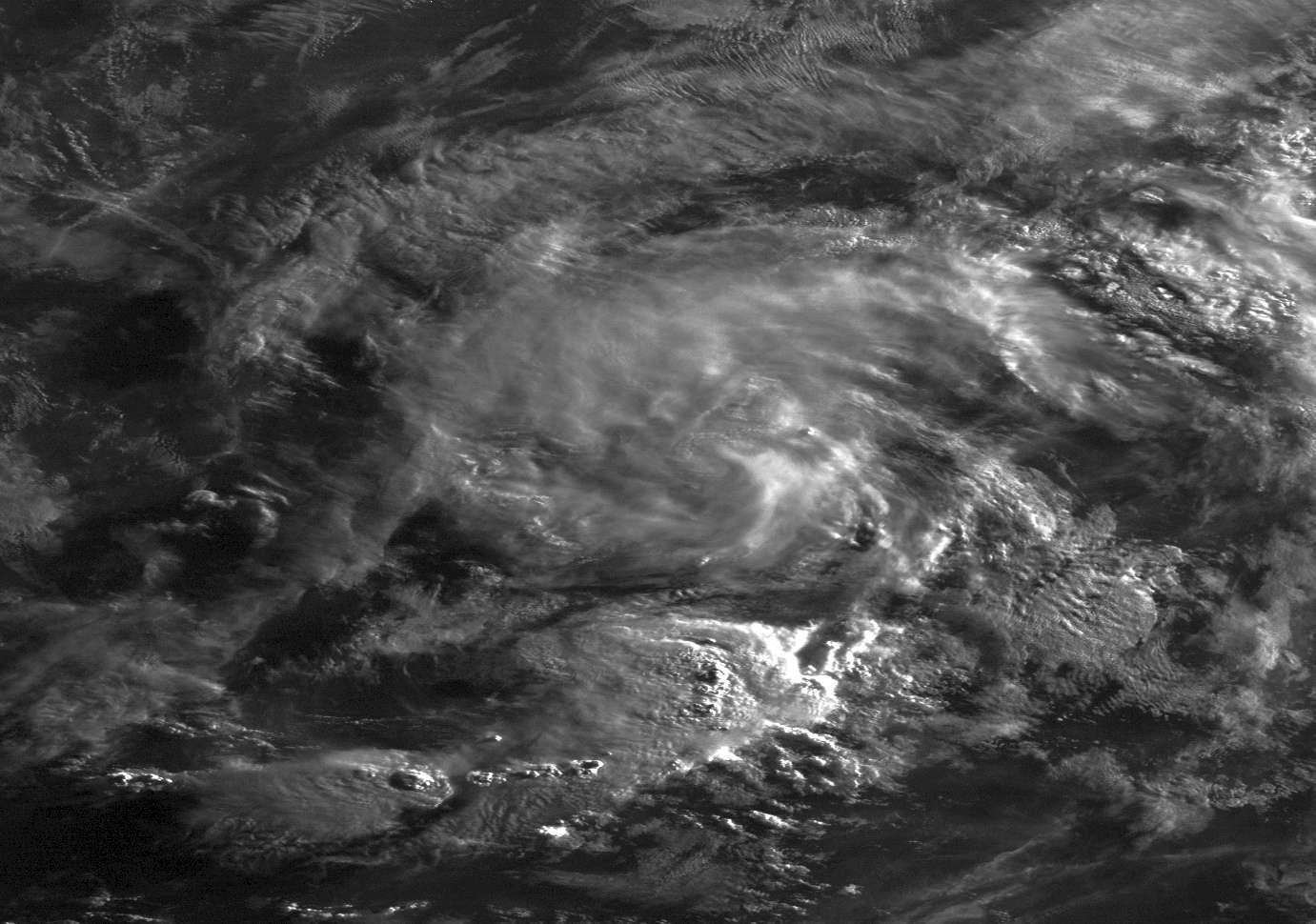
by the looks of the latest satellite loop, Barbara is speeding up, its very near the 12z forecast point. It also seems to be pulling in warm Gulf air, as there are storms firing along the western feeder band, and high clouds are continuing to fan out away from it, so this could be the first system to move intact across Mexico since (I believe) 1949 if the trend continues.
0 likes
The above post is not official and should not be used as such. It is the opinion of the poster and may or may not be backed by sound meteorological data. It is not endorsed by any professional institution or storm2k.org. For official information, please refer to the NHC and NWS products.
-
brunota2003

- S2K Supporter

- Posts: 9476
- Age: 33
- Joined: Sat Jul 30, 2005 9:56 pm
- Location: Stanton, KY...formerly Havelock, NC
- Contact:
-
Kingarabian

- S2K Supporter
- Posts: 15435
- Joined: Sat Aug 08, 2009 3:06 am
- Location: Honolulu, Hawaii
-
Kingarabian
- S2K Supporter
- Posts: 15435
- Joined: Sat Aug 08, 2009 3:06 am
- Location: Honolulu, Hawaii
000
WTPZ42 KNHC 300835
TCDEP2
TROPICAL DEPRESSION BARBARA DISCUSSION NUMBER 8
NWS NATIONAL HURRICANE CENTER MIAMI FL EP022013
200 AM PDT THU MAY 30 2013
BARBARA CONTINUES TO WEAKEN AS THE CENTER MOVES NORTHWARD OVER
SOUTHEASTERN MEXICO. BASED ON THE TIME SPENT OVER LAND AND THE
LACK OF ANY REPORTS OF TROPICAL STORM FORCE WINDS FOR SEVERAL
HOURS...THE INITIAL INTENSITY IS LOWERED TO 30 KT FOR THIS ADVISORY.
GLOBAL MODEL FIELDS SHOW THE LOW-LEVEL CIRCULATION DISSIPATING
SOON...AND THE NEW NHC FORECAST CONTINUES TO FOLLOW THAT
REASONING. A REMNANT LOW IS FORECAST AT 12 HOURS OVER THE EXTREME
SOUTHWESTERN GULF OF MEXICO WITH DISSIPATION SHOWN AT 24 HOURS.
HOWEVER...THERE HAS BEEN A NEW BURST OF CONVECTION NORTH OF
THE CENTER IN THE PAST COUPLE OF HOURS. IF ORGANIZED DEEP
CONVECTION AND A WELL-DEFINED CIRCULATION ARE MAINTAINED...BARBARA
COULD EMERGE INTO THE GULF OF MEXICO AS A TROPICAL CYCLONE LATER
THIS MORNING. PLEASE NOTE THAT IF THIS OCCURS...THE NEXT ADVISORY
WOULD BE ISSUED WITH ATLANTIC BASIN TROPICAL CYCLONE PRODUCTS AND
HEADERS.
DESPITE THE WEAKENING OF THE CYCLONE...THE MAIN CONCERN CONTINUES TO
BE HEAVY RAIN OVER PORTIONS OF SOUTHEASTERN MEXICO. DISTURBED
WEATHER ASSOCIATED WITH THE REMNANTS OF BARBARA IS LIKELY
TO PERSIST OVER SOUTHEASTERN MEXICO AND PORTIONS OF CENTRAL AMERICA
FOR THE NEXT SEVERAL DAYS...AND A HEIGHTENED RISK OF DANGEROUS
FLOODING AND MUD SLIDES WILL CONTINUE OVER THIS REGION.
FORECAST POSITIONS AND MAX WINDS
INIT 30/0900Z 17.8N 93.9W 30 KT 35 MPH
12H 30/1800Z 18.7N 94.0W 25 KT 30 MPH...POST-TROP/REMNT LOW
24H 31/0600Z...DISSIPATED
$$
FORECASTER BRENNAN
Who knows...
0 likes
RIP Kobe Bryant
-
HurricaneBill
- Category 5

- Posts: 3420
- Joined: Sun Apr 11, 2004 5:51 pm
- Location: East Longmeadow, MA, USA
Re: EPAC: BARBARA - Tropical Storm
[youtube]http://www.youtube.com/watch?v=qx4-tWR6R78[/youtube]
[youtube]http://www.youtube.com/watch?v=KQn_QUc_Iow[/youtube]
[youtube]http://www.youtube.com/watch?v=WH79ouoRBiQ[/youtube]
[youtube]http://www.youtube.com/watch?v=ip8-eIEFSVs[/youtube]
[youtube]http://www.youtube.com/watch?v=KQn_QUc_Iow[/youtube]
[youtube]http://www.youtube.com/watch?v=WH79ouoRBiQ[/youtube]
[youtube]http://www.youtube.com/watch?v=ip8-eIEFSVs[/youtube]
0 likes
-
Kingarabian
- S2K Supporter
- Posts: 15435
- Joined: Sat Aug 08, 2009 3:06 am
- Location: Honolulu, Hawaii

-
weatherwindow

- Category 4

- Posts: 904
- Joined: Mon Sep 20, 2004 9:48 am
- Location: key west/ft lauderdale
Re:
Kingarabian wrote:000
WTPZ42 KNHC 300835
TCDEP2
TROPICAL DEPRESSION BARBARA DISCUSSION NUMBER 8
NWS NATIONAL HURRICANE CENTER MIAMI FL EP022013
200 AM PDT THU MAY 30 2013
BARBARA CONTINUES TO WEAKEN AS THE CENTER MOVES NORTHWARD OVER
SOUTHEASTERN MEXICO. BASED ON THE TIME SPENT OVER LAND AND THE
LACK OF ANY REPORTS OF TROPICAL STORM FORCE WINDS FOR SEVERAL
HOURS...THE INITIAL INTENSITY IS LOWERED TO 30 KT FOR THIS ADVISORY.
GLOBAL MODEL FIELDS SHOW THE LOW-LEVEL CIRCULATION DISSIPATING
SOON...AND THE NEW NHC FORECAST CONTINUES TO FOLLOW THAT
REASONING. A REMNANT LOW IS FORECAST AT 12 HOURS OVER THE EXTREME
SOUTHWESTERN GULF OF MEXICO WITH DISSIPATION SHOWN AT 24 HOURS.
HOWEVER...THERE HAS BEEN A NEW BURST OF CONVECTION NORTH OF
THE CENTER IN THE PAST COUPLE OF HOURS. IF ORGANIZED DEEP
CONVECTION AND A WELL-DEFINED CIRCULATION ARE MAINTAINED...BARBARA
COULD EMERGE INTO THE GULF OF MEXICO AS A TROPICAL CYCLONE LATER
THIS MORNING. PLEASE NOTE THAT IF THIS OCCURS...THE NEXT ADVISORY
WOULD BE ISSUED WITH ATLANTIC BASIN TROPICAL CYCLONE PRODUCTS AND
HEADERS.
DESPITE THE WEAKENING OF THE CYCLONE...THE MAIN CONCERN CONTINUES TO
BE HEAVY RAIN OVER PORTIONS OF SOUTHEASTERN MEXICO. DISTURBED
WEATHER ASSOCIATED WITH THE REMNANTS OF BARBARA IS LIKELY
TO PERSIST OVER SOUTHEASTERN MEXICO AND PORTIONS OF CENTRAL AMERICA
FOR THE NEXT SEVERAL DAYS...AND A HEIGHTENED RISK OF DANGEROUS
FLOODING AND MUD SLIDES WILL CONTINUE OVER THIS REGION.
FORECAST POSITIONS AND MAX WINDS
INIT 30/0900Z 17.8N 93.9W 30 KT 35 MPH
12H 30/1800Z 18.7N 94.0W 25 KT 30 MPH...POST-TROP/REMNT LOW
24H 31/0600Z...DISSIPATED
$$
FORECASTER BRENNAN
Who knows...
Good morning, King...from a quick perusal of the IR sat, we certainly have deep convection and a discernable circulation...Persistance will be the key. If so, I believe the NHC will pull the trigger at 1100 this morning...Rich
0 likes
-
dexterlabio
- Category 5
- Posts: 3407
- Joined: Sat Oct 24, 2009 11:50 pm
Re: EPAC: BARBARA - Tropical Storm
The convection firing north of its center is interesting... And much more interesting if it's still called Barbara as it enters the Atlantic region. First named Atlantic tropical cyclone of the season that doesn't start with an 'A'?  That's fun.
0 likes
Personal Forecast Disclaimer:
The posts in this forum are NOT official forecast and should not be used as such. They are just the opinion of the poster and may or may not be backed by sound meteorological data. They are NOT endorsed by any professional institution or storm2k.org. For official information, please refer to the NHC and NWS products.
The posts in this forum are NOT official forecast and should not be used as such. They are just the opinion of the poster and may or may not be backed by sound meteorological data. They are NOT endorsed by any professional institution or storm2k.org. For official information, please refer to the NHC and NWS products.
-
StormingB81

- S2K Supporter
- Posts: 5676
- Age: 42
- Joined: Thu Aug 27, 2009 1:45 am
- Location: Rockledge, Florida
Re: EPAC: BARBARA - Tropical Storm
dexterlabio wrote:The convection firing north of its center is interesting... And much more interesting if it's still called Barbara as it enters the Atlantic region. First named Atlantic tropical cyclone of the season that doesn't start with an 'A'?
I thought they get renumbered. I forgot what storm it was last year went from the atlantic and became a new invest when it entered into the pacific. If so how would that be counted as for the numbers? Sorry if it sounds liek a stupid question I am guessing it would be considered as any other storm whether its a TD or TS or whatever it would be counted as that in the numbers for how many storms we had in a year.
0 likes
-
dexterlabio
- Category 5
- Posts: 3407
- Joined: Sat Oct 24, 2009 11:50 pm
Re: EPAC: BARBARA - Tropical Depression
^They were saying if Barbara remains a tropical cyclone, then it would still be Barbara as it enters the gulf. That is yet to be known, though. Forecasts say that the shear will be too high and Barbara will be an open wave soon BUT who knows. It will be just cool to see a crossover storm in the Atlantic region without changing its name.
0 likes
Personal Forecast Disclaimer:
The posts in this forum are NOT official forecast and should not be used as such. They are just the opinion of the poster and may or may not be backed by sound meteorological data. They are NOT endorsed by any professional institution or storm2k.org. For official information, please refer to the NHC and NWS products.
The posts in this forum are NOT official forecast and should not be used as such. They are just the opinion of the poster and may or may not be backed by sound meteorological data. They are NOT endorsed by any professional institution or storm2k.org. For official information, please refer to the NHC and NWS products.
Re: EPAC: BARBARA - Tropical Depression
Southwesterly shear north of 20N is very strong and that's no doubt why the NHC has forecast dissipation beyond 24 hours, but as the NHC and others here have said apparently it's surviving the crossing into the Gulf (BOC)...
P.S. Our rainy season is off to a big start down here with 6-15 inches of rain during one rainfall event 10 days ago, and now 2-6 in a second event the past 2 days, but hard to say if the season will match the 8 feet of rain recorded at Miami International Airport in 2012, so any leftover moisture from Barbara will only add to what we already have accumulated this month...
Frank
0 likes
-
cycloneye

- Admin

- Posts: 139090
- Age: 67
- Joined: Thu Oct 10, 2002 10:54 am
- Location: San Juan, Puerto Rico
Re: EPAC: BARBARA - Tropical Depression
A note to the members about the crossover by Barbara from EPAC to BOC is that Storm2k management will not do anything about changing titles,locking threads or adding Invest 90L to this forum until there is official word by NHC about this.
0 likes
Visit the Caribbean-Central America Weather Thread where you can find at first post web cams,radars
and observations from Caribbean basin members Click Here
and observations from Caribbean basin members Click Here
-
cycloneye
- Admin
- Posts: 139090
- Age: 67
- Joined: Thu Oct 10, 2002 10:54 am
- Location: San Juan, Puerto Rico
Re: EPAC: BARBARA - Tropical Depression
The new Best Track at 12z mantains as TD.
EP, 02, 2013053012, , BEST, 0, 183N, 943W, 25, 1004, TD
ftp://ftp.nhc.noaa.gov/atcf/tcweb/inves ... 013.invest
EP, 02, 2013053012, , BEST, 0, 183N, 943W, 25, 1004, TD
ftp://ftp.nhc.noaa.gov/atcf/tcweb/inves ... 013.invest
0 likes
Visit the Caribbean-Central America Weather Thread where you can find at first post web cams,radars
and observations from Caribbean basin members Click Here
and observations from Caribbean basin members Click Here
-
tolakram
- Admin
- Posts: 19165
- Age: 60
- Joined: Sun Aug 27, 2006 8:23 pm
- Location: Florence, KY (name is Mark)
Re: EPAC: BARBARA - Tropical Depression
12:15Z, 8:15EDT
0 likes
M a r k
- - - - -
Join us in chat: Storm2K Chatroom Invite. Android and IOS apps also available.
The posts in this forum are NOT official forecasts and should not be used as such. Posts are NOT endorsed by any professional institution or STORM2K.org. For official information and forecasts, please refer to NHC and NWS products.
-
tolakram
- Admin
- Posts: 19165
- Age: 60
- Joined: Sun Aug 27, 2006 8:23 pm
- Location: Florence, KY (name is Mark)
Re: EPAC: BARBARA - Tropical Depression
Link for updating sat images: http://www.ssec.wisc.edu/data/geo/index ... thod=flash
0 likes
M a r k
- - - - -
Join us in chat: Storm2K Chatroom Invite. Android and IOS apps also available.
The posts in this forum are NOT official forecasts and should not be used as such. Posts are NOT endorsed by any professional institution or STORM2K.org. For official information and forecasts, please refer to NHC and NWS products.
- - - - -
Join us in chat: Storm2K Chatroom Invite. Android and IOS apps also available.
The posts in this forum are NOT official forecasts and should not be used as such. Posts are NOT endorsed by any professional institution or STORM2K.org. For official information and forecasts, please refer to NHC and NWS products.
-
Hurricaneman

- Category 5
- Posts: 7282
- Age: 43
- Joined: Tue Aug 31, 2004 3:24 pm
- Location: central florida
Re: EPAC: BARBARA - Tropical Depression
I have a feeling this will be moved to the atlantic basin as of 11AM, it just looks too good
0 likes
Who is online
Users browsing this forum: No registered users and 107 guests