EPAC: BARBARA - Remnants

Moderator: S2k Moderators

Message
Author
RL3AO
Moderator-Pro Met
Moderator-Pro Met
Posts: 16308
Joined: Thu Jun 14, 2007 10:03 pm
Location: NC

Re: Re:

#161 Postby RL3AO » Thu May 30, 2013 11:14 am

TheEuropean wrote:
Phoenix's Song wrote:
RL3AO wrote:This would be a first to survive the EPac to Atlantic passage correct? Like I said last night, it took the perfect path.

I believe the last time was in 1949.


Last time it was Northeast Pacific Hurricane Cosme that became Atlantic Tropical Storm Allison (June 1989).

Source: FAQ http://www.aoml.noaa.gov/hrd/tcfaq/tcfaqHED.html
(german version: http://www.naturgewalten.de/hurrikan/hurrfaq.htm)

Thomas


Allison formed from Cosme's remnants. I'm talking about a system maintaining itself as a tropical cyclone from the Pacific basin to the Atlantic Basin.
0 likes   

tolakram
Admin
Admin
Posts: 19165
Age: 60
Joined: Sun Aug 27, 2006 8:23 pm
Location: Florence, KY (name is Mark)

Re: EPAC: BARBARA - Tropical Depression

#162 Postby tolakram » Thu May 30, 2013 12:11 pm

http://www.ssec.wisc.edu/data/geo/index ... thod=jsani

You can see the LLC of Invest 91E in this live loop as well. So far I don't see any signs of an LLC left with Barbara.
0 likes   
M a r k
- - - - -
Join us in chat: Storm2K Chatroom Invite. Android and IOS apps also available.

The posts in this forum are NOT official forecasts and should not be used as such. Posts are NOT endorsed by any professional institution or STORM2K.org. For official information and forecasts, please refer to NHC and NWS products.

User avatar
cycloneye
Admin
Admin
Posts: 139060
Age: 67
Joined: Thu Oct 10, 2002 10:54 am
Location: San Juan, Puerto Rico

Re: EPAC: BARBARA - Tropical Depression

#163 Postby cycloneye » Thu May 30, 2013 12:16 pm

Here is a video of the effects caused by Barbara in Mexico.

http://www.youtube.com/watch?feature=pl ... JBHnnKuCBw
0 likes   
Visit the Caribbean-Central America Weather Thread where you can find at first post web cams,radars
and observations from Caribbean basin members Click Here

User avatar
HurricaneBelle
S2K Supporter
S2K Supporter
Posts: 974
Joined: Sun Aug 27, 2006 6:12 pm
Location: Clearwater, FL

Re:

#164 Postby HurricaneBelle » Thu May 30, 2013 12:50 pm

Alyono wrote:There is nothing where NHC put the center. Not sure how they got 95W. I wonder if they simply do not want this in the BOC since it should die soon anyways


This is the kind of thing I find galling about the NHC, which otherwise does a great job. There's no CoC at 95W, which is obvious from any satellite imagery. They're telling us up is down, black is white, etc., when the evidence is plain to see.

They just don't want to be bothered with having to open up a North Atlantic file on this, with advisories, etc. on a system that is likely to dissipate. But it hasn't dissipated yet and it's in the Gulf of Mexico, but instead they're fabricating a position for it that's inland.

And it also plays into their inherent conflict of interest where they are the entity that issues the forecasts and then verifies them by making the determination about how strong and (now in this instance, where) the cyclone is. I'm not imputing any kind of evil conspiracy here, and again they do a wonderful job overall, but this is just the natural inclination of any bureaucracy to take the path of least resistance.
0 likes   

ozonepete
Professional-Met
Professional-Met
Posts: 4743
Joined: Mon Sep 07, 2009 3:23 pm
Location: From Ozone Park, NYC / Now in Brooklyn, NY

Re: EPAC: BARBARA - Tropical Depression

#165 Postby ozonepete » Thu May 30, 2013 1:17 pm

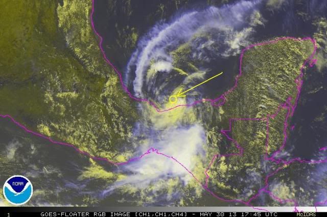
I see an LLC (or almost all the way to the surface) on the loops. Here's where I see it using the RGB satellite.

Image
0 likes   

User avatar
Riptide
Category 2
Category 2
Posts: 753
Age: 32
Joined: Fri Jul 23, 2010 3:33 pm
Location: Cape May, New Jersey
Contact:

Re: EPAC: BARBARA - Tropical Depression

#166 Postby Riptide » Thu May 30, 2013 1:17 pm

Barbara does not seem to be in a disruptive mode, the low level circulation is a bit elongated. It seems she survived the land battle but how will she deal with shear and dry air?
0 likes   

User avatar
vbhoutex
Storm2k Executive
Storm2k Executive
Posts: 28974
Age: 72
Joined: Wed Oct 09, 2002 11:31 pm
Location: Spring Branch area, Houston, TX
Contact:

Re: Re:

#167 Postby vbhoutex » Thu May 30, 2013 1:18 pm

HurricaneBelle wrote:
Alyono wrote:There is nothing where NHC put the center. Not sure how they got 95W. I wonder if they simply do not want this in the BOC since it should die soon anyways


This is the kind of thing I find galling about the NHC, which otherwise does a great job. There's no CoC at 95W, which is obvious from any satellite imagery. They're telling us up is down, black is white, etc., when the evidence is plain to see.

They just don't want to be bothered with having to open up a North Atlantic file on this, with advisories, etc. on a system that is likely to dissipate. But it hasn't dissipated yet and it's in the Gulf of Mexico, but instead they're fabricating a position for it that's inland.

And it also plays into their inherent conflict of interest where they are the entity that issues the forecasts and then verifies them by making the determination about how strong and (now in this instance, where) the cyclone is. I'm not imputing any kind of evil conspiracy here, and again they do a wonderful job overall, but this is just the natural inclination of any bureaucracy to take the path of least resistance.

I have to disagree with the reasoning stated here. How do you know they don't want to open a file on it? Do you have an inside track to NHC we don't know about? If you aren't imputing a conspiracy here, then what are you imputing? Conflict of interest?? Come on, it is their job and it is not a conflict of interest. Many corporations/public agencies do their own verifications.
0 likes   
Skywarn, C.E.R.T.
Please click below to donate to STORM2K to help with the expenses of keeping the site going:
Image

ozonepete
Professional-Met
Professional-Met
Posts: 4743
Joined: Mon Sep 07, 2009 3:23 pm
Location: From Ozone Park, NYC / Now in Brooklyn, NY

Re: EPAC: BARBARA - Tropical Depression

#168 Postby ozonepete » Thu May 30, 2013 1:24 pm

:uarrow: I have to agree. The NHC senior forecasters live for this stuff - they love it like we do and I would imagine they get just as excited as we do when possibly historic things like this occur. They are just being cautious. Who can blame them for wanting to be right? ...lol
0 likes   

ozonepete
Professional-Met
Professional-Met
Posts: 4743
Joined: Mon Sep 07, 2009 3:23 pm
Location: From Ozone Park, NYC / Now in Brooklyn, NY

Re: EPAC: BARBARA - Tropical Depression

#169 Postby ozonepete » Thu May 30, 2013 1:30 pm

Riptide wrote:Barbara does not seem to be in a disruptive mode, the low level circulation is a bit elongated. It seems she survived the land battle but how will she deal with shear and dry air?


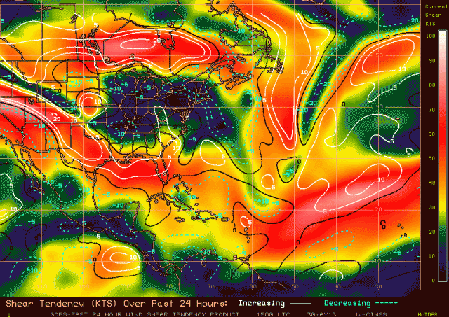
Right now shear is very low over Barbara and dropping - see the attached shear and shear tendency chart from CIMSS. So if it remains nearly stationary or moves slowly shear won't be a problem for the next day or so. I haven't checked the mid level RH values for dry air but you would think air coming into the circulation from land, especially air drying as it descends the mountains, is keeping convection down. It's got to get a little further north.

Image
0 likes   

User avatar
Kingarabian
S2K Supporter
S2K Supporter
Posts: 15434
Joined: Sat Aug 08, 2009 3:06 am
Location: Honolulu, Hawaii

#170 Postby Kingarabian » Thu May 30, 2013 1:32 pm

Good to see you Pete!

What time does the NHC update the ATCF files?
Last edited by Kingarabian on Thu May 30, 2013 1:35 pm, edited 1 time in total.
0 likes   
RIP Kobe Bryant

User avatar
HurricaneBelle
S2K Supporter
S2K Supporter
Posts: 974
Joined: Sun Aug 27, 2006 6:12 pm
Location: Clearwater, FL

Re: Re:

#171 Postby HurricaneBelle » Thu May 30, 2013 1:33 pm

vbhoutex wrote:I have to disagree with the reasoning stated here. How do you know they don't want to open a file on it? Do you have an inside track to NHC we don't know about? If you aren't imputing a conspiracy here, then what are you imputing? Conflict of interest?? Come on, it is their job and it is not a conflict of interest. Many corporations/public agencies do their own verifications.


1. They're still calling it a depression.
2. They're saying the center is inland at 95W. There's no objective support for that.

How else to reconcile #1 and #2? No, I'm not in the room at NHC, so I will gladly amend my comment to add "it seems" or "probably" with respect to my belief they don't want to open a North Atlantic file on it (and about 3-4 others upthread are wondering the same thing) But this isn't the first time I've seen questionable reports of the position or intensity of a storm in the dissipation phase that err on the side of what they had forecasted,.

I'll state again that 99% of the time, they do a great job and they're outstanding meteorologists who perform a valuable public service. But it seems there are occasionally political (in the bureaucratic sense) decisions that get made that don't seem to be 100% based on the science.
0 likes   

User avatar
Kingarabian
S2K Supporter
S2K Supporter
Posts: 15434
Joined: Sat Aug 08, 2009 3:06 am
Location: Honolulu, Hawaii

#172 Postby Kingarabian » Thu May 30, 2013 1:36 pm

You know hopefully once this re-emerges in the BOC we can get some Recon. It would be very helpful. Just one pass over the suggested center and see if anything exists. Then just measure the wind speed and we won't ever ever ever ask for Recon again.
0 likes   
RIP Kobe Bryant

User avatar
Riptide
Category 2
Category 2
Posts: 753
Age: 32
Joined: Fri Jul 23, 2010 3:33 pm
Location: Cape May, New Jersey
Contact:

Re: Re:

#173 Postby Riptide » Thu May 30, 2013 1:40 pm

HurricaneBelle wrote:
vbhoutex wrote:I have to disagree with the reasoning stated here. How do you know they don't want to open a file on it? Do you have an inside track to NHC we don't know about? If you aren't imputing a conspiracy here, then what are you imputing? Conflict of interest?? Come on, it is their job and it is not a conflict of interest. Many corporations/public agencies do their own verifications.


1. They're still calling it a depression.
2. They're saying the center is inland at 95W. There's no objective support for that.

How else to reconcile #1 and #2? No, I'm not in the room at NHC, so I will gladly amend my comment to add "it seems" or "probably" with respect to my belief they don't want to open a North Atlantic file on it (and about 3-4 others upthread are wondering the same thing) But this isn't the first time I've seen questionable reports of the position or intensity of a storm in the dissipation phase that err on the side of what they had forecasted,.

I'll state again that 99% of the time, they do a great job and they're outstanding meteorologists who perform a valuable public service. But it seems there are occasionally political (in the bureaucratic sense) decisions that get made that don't seem to be 100% based on the science.

Perhaps one could blame the general population for the new mindset of the NHC. They changed their forecasting scheme to allow hurricane warnings to remain in the event that a tropical cyclone becomes extratropical before landfall (Hurricane Sandy). However, I think it's not good to rush to conclusion. Mid-level vorticies can be deceiving and there may not be an LLC.

The 100% scientific approach appears to be unpopular because of the human factor.
0 likes   

User avatar
cycloneye
Admin
Admin
Posts: 139060
Age: 67
Joined: Thu Oct 10, 2002 10:54 am
Location: San Juan, Puerto Rico

Re: EPAC: BARBARA - Tropical Depression

#174 Postby cycloneye » Thu May 30, 2013 1:42 pm

18z Best Track. Downgraded from TD.

EP, 02, 2013053018, , BEST, 0, 185N, 945W, 20, 1005, DB

ftp://ftp.nhc.noaa.gov/atcf/tcweb/inves ... 013.invest
0 likes   
Visit the Caribbean-Central America Weather Thread where you can find at first post web cams,radars
and observations from Caribbean basin members Click Here

User avatar
Kingarabian
S2K Supporter
S2K Supporter
Posts: 15434
Joined: Sat Aug 08, 2009 3:06 am
Location: Honolulu, Hawaii

Re: EPAC: BARBARA - Tropical Depression

#175 Postby Kingarabian » Thu May 30, 2013 1:46 pm

cycloneye wrote:18z Best Track.

EP, 02, 2013053018, , BEST, 0, 185N, 945W, 25, 1005, TD

ftp://ftp.nhc.noaa.gov/atcf/tcweb/inves ... 013.invest


EP, 02, 2013053018, , BEST, 0, 185N, 945W, 20, 1005, DB

I guess she's gone.
0 likes   
RIP Kobe Bryant

User avatar
cycloneye
Admin
Admin
Posts: 139060
Age: 67
Joined: Thu Oct 10, 2002 10:54 am
Location: San Juan, Puerto Rico

Re: EPAC: BARBARA - Tropical Depression

#176 Postby cycloneye » Thu May 30, 2013 1:47 pm

Kingarabian wrote:
cycloneye wrote:18z Best Track.

EP, 02, 2013053018, , BEST, 0, 185N, 945W, 25, 1005, TD

ftp://ftp.nhc.noaa.gov/atcf/tcweb/inves ... 013.invest


EP, 02, 2013053018, , BEST, 0, 185N, 945W, 20, 1005, DB

I guess she's gone.


Yes,I noted the change in minutes after I posted and is fixed.Hasta la vista.
0 likes   
Visit the Caribbean-Central America Weather Thread where you can find at first post web cams,radars
and observations from Caribbean basin members Click Here

tolakram
Admin
Admin
Posts: 19165
Age: 60
Joined: Sun Aug 27, 2006 8:23 pm
Location: Florence, KY (name is Mark)

Re: Re:

#177 Postby tolakram » Thu May 30, 2013 2:13 pm

HurricaneBelle wrote:1. They're still calling it a depression.
2. They're saying the center is inland at 95W. There's no objective support for that.

How else to reconcile #1 and #2? No, I'm not in the room at NHC, so I will gladly amend my comment to add "it seems" or "probably" with respect to my belief they don't want to open a North Atlantic file on it (and about 3-4 others upthread are wondering the same thing) But this isn't the first time I've seen questionable reports of the position or intensity of a storm in the dissipation phase that err on the side of what they had forecasted,.

I'll state again that 99% of the time, they do a great job and they're outstanding meteorologists who perform a valuable public service. But it seems there are occasionally political (in the bureaucratic sense) decisions that get made that don't seem to be 100% based on the science.


I think you're crossing the line on this one without any data to back it up.

Here is the discussion:

FINDING THE LOW-LEVEL CENTER OF THE CYCLONE HAS BEEN A REAL
CHALLENGE THIS MORNING. THE CENTER OF ROTATION THAT IS EVIDENT ON
VISIBLE SATELLITE IMAGERY IS NOT CONSISTENT WITH SURFACE WIND
OBSERVATIONS FROM STANDARD AND AUTOMATED MEXICAN WEATHER STATIONS.
IN FACT...THERE IS SOME DOUBT THAT A WELL-DEFINED SURFACE CENTER
EVEN EXISTS. HOWEVER...WE THINK THE MOST PRUDENT ACTION AT THIS
TIME IS TO MAINTAIN THE SYSTEM AS A DEPRESSION UNTIL ADDITIONAL
VISIBLE IMAGES AND SURFACE DATA BECOME AVAILABLE. THE CURRENT
ADVISORY POSITION IS IN REASONABLE AGREEMENT WITH THE SURFACE WIND
DATA.

Are you questioning the surface wind data, or can you show surface wind data that contradicts the above statement? In addition without reliable data, the position may well follow forecast positions for continuity sake.
0 likes   
M a r k
- - - - -
Join us in chat: Storm2K Chatroom Invite. Android and IOS apps also available.

The posts in this forum are NOT official forecasts and should not be used as such. Posts are NOT endorsed by any professional institution or STORM2K.org. For official information and forecasts, please refer to NHC and NWS products.

ozonepete
Professional-Met
Professional-Met
Posts: 4743
Joined: Mon Sep 07, 2009 3:23 pm
Location: From Ozone Park, NYC / Now in Brooklyn, NY

Re:

#178 Postby ozonepete » Thu May 30, 2013 2:15 pm

Kingarabian wrote:Good to see you Pete!

What time does the NHC update the ATCF files?


Good to see you again, King! (I guess you got your answer.)
0 likes   

ozonepete
Professional-Met
Professional-Met
Posts: 4743
Joined: Mon Sep 07, 2009 3:23 pm
Location: From Ozone Park, NYC / Now in Brooklyn, NY

Re: EPAC: BARBARA - Tropical Depression

#179 Postby ozonepete » Thu May 30, 2013 2:53 pm

I wouldn't call Bones yet. It's gotten more symmetric and some convection is flaring. This is also climatologically a good area for formation or maintenance at this time of year and there is virtually no shear over it. Of course if it does come back it probably won't survive long anyway, but it looks like it's got a window here to get to TS before the shouting is over.
0 likes   

User avatar
thetruesms
Professional-Met
Professional-Met
Posts: 844
Age: 40
Joined: Thu Aug 16, 2007 1:14 pm
Location: Tallahasee, FL
Contact:

#180 Postby thetruesms » Thu May 30, 2013 2:53 pm

Actually, I think the fairly strange placement of the center (which I think has slightly more to do with surface obs than satellite imagery) is not a reluctance to move Barbara over, but rather to keep her.

Pretty simply, I don't see anything at the surface at all right now, especially when you consider surface obs. But - there might be in the future with some luck since there's still some midlevel spin and obviously some low level convergence over the water where convection is flaring. So, for continuity's sake, they'll keep Barbara around for one more advisory and see what happens. This is nothing new from NHC.

But that introduces a problem - where do you put her? There's not really anything to pin it to. So, do you move her to the Atlantic in case she beats the odds and pulls something together in the Bay of Campeche? You could, but it's probably a whole lot of work, and if you don't really think it's going to pull together over water, kind of pointless. Or since you're picking a conservative route to begin with, do you stay conservative, and keep her in the EPac over land and see what happens? It looks like they used some surface obs (namely an "apparent land breeze" where there should be a sea breeze) to pick something over land to the west of where a new center over water might form.

I don't think either is technically right; for that you'd probably call the circulation opened, declare Barbara done, and start up Andrea if something comes back together at the surface. And that's also precisely what you'd do if you didn't want to shift Barbara to the Atlantic. The fact that she's still around says more to me of their willingness, rather than reluctance to open the Atlantic season with a B storm.
0 likes   


Return to “2013”

Who is online

Users browsing this forum: No registered users and 123 guests