WPAC: SOULIK- Post-Tropical
Moderator: S2k Moderators


Re: WPAC: SOULIK- Typhoon
Wow, these images are incredible. Please stay safe all who are in the path.
0 likes
The following post is NOT an official forecast and should not be used as such. It is just the opinion of the poster and may or may not be backed by sound meteorological data. It is NOT endorsed by any professional institution including storm2k.org. For Official Information please refer to the NHC and NWS products.
-
'CaneFreak

- Category 5

- Posts: 1475
- Joined: Mon Jun 05, 2006 10:50 am
- Location: New Bern, NC
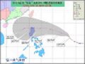
The current updated 5 pm track from the JTWC takes Soulik just south of Taipei with sustained winds of approximately 110 mph. HMMM...if this track holds/verifies, they may see some of the strongest winds.

Uploaded with ImageShack.us

Uploaded with ImageShack.us
0 likes
-
Filipinas50
- Tropical Depression

- Posts: 77
- Age: 59
- Joined: Tue May 28, 2013 2:07 am
- Location: Planet Earth

-
weathernerdguy

- Tropical Storm

- Posts: 188
- Age: 22
- Joined: Wed Jul 10, 2013 8:44 pm
Re: WPAC: SOULIK- Typhoon
Typhoon soulik is now getting stronger after having the dry air mishap which caused the EWRC. http://tropic.ssec.wisc.edu/real-time/m ... hr_06.html
0 likes
The posts in this forum are NOT official forecast and should not be used as such. They are just the opinion of the poster and may or may not be backed by sound meteorological data. They are NOT endorsed by any professional institution or storm2k.org. For official information, please refer to the NHC and NWS products
-
mrbagyo

- Category 5
- Posts: 3614
- Age: 31
- Joined: Thu Apr 12, 2012 9:18 am
- Location: 14.13N 120.98E
- Contact:
Re: WPAC: SOULIK- Typhoon
radar loop from Taiwan... rainbands starting to show up
http://www.cwb.gov.tw/V7e/observe/radar/#
http://www.weatheronline.co.uk/cgi-app/radar?CONT=asie&CREG=tw<YP=tag&LANG=en&STRUCTUR=_&W=0&L=0&SLP=0&ROAD=0&CITY=&LOOP=1
http://www.cwb.gov.tw/V7e/observe/radar/#
http://www.weatheronline.co.uk/cgi-app/radar?CONT=asie&CREG=tw<YP=tag&LANG=en&STRUCTUR=_&W=0&L=0&SLP=0&ROAD=0&CITY=&LOOP=1
0 likes
The posts in this forum are NOT official forecast and should not be used as such. They are just the opinion of the poster and may or may not be backed by sound meteorological data. They are NOT endorsed by any professional institution or storm2k.org. For official information, please refer to RSMC, NHC and NWS products.
-
mrbagyo
- Category 5
- Posts: 3614
- Age: 31
- Joined: Thu Apr 12, 2012 9:18 am
- Location: 14.13N 120.98E
- Contact:
Re: WPAC: SOULIK- Typhoon

will make landfall within 24 hours
0 likes
The posts in this forum are NOT official forecast and should not be used as such. They are just the opinion of the poster and may or may not be backed by sound meteorological data. They are NOT endorsed by any professional institution or storm2k.org. For official information, please refer to RSMC, NHC and NWS products.
-
weathernerdguy
- Tropical Storm
- Posts: 188
- Age: 22
- Joined: Wed Jul 10, 2013 8:44 pm
the 10 guests that are here,We all want to talk to you! 
0 likes
The posts in this forum are NOT official forecast and should not be used as such. They are just the opinion of the poster and may or may not be backed by sound meteorological data. They are NOT endorsed by any professional institution or storm2k.org. For official information, please refer to the NHC and NWS products


-
RobWESTPACWX
- WestPACMet

- Posts: 1616
- Joined: Fri Sep 17, 2010 2:26 am
- Location: Tokyo, Japan
- Contact:
Re: WPAC: SOULIK- Typhoon
Winds now gusting over 110kph on Miyako-jima and Ishigaki, its going to be a long day.
I just made a webcast below.
[youtube]http://www.youtube.com/watch?v=5rRJqI8O7nE[/youtube]
I just made a webcast below.
[youtube]http://www.youtube.com/watch?v=5rRJqI8O7nE[/youtube]
0 likes
Satellites, Charts and Forecasting tools for East Asia at WESTERNPACIFICWEATHER.COM


Re: WPAC: SOULIK- Typhoon

huge eye coming into view...
0 likes
Remember, all of my post aren't official. For official warnings and discussions, Please refer to your local NWS products...
NWS for the Western Pacific
https://www.weather.gov/gum/
NWS for the Western Pacific
https://www.weather.gov/gum/
-
mrbagyo
- Category 5
- Posts: 3614
- Age: 31
- Joined: Thu Apr 12, 2012 9:18 am
- Location: 14.13N 120.98E
- Contact:
Re: WPAC: SOULIK- Typhoon

It can't complete the EWRC but still having a nice outflow channel especially to the southeast due to a TUTT cell...
and look - there is a tiny and completely naked LLC near a trough in the open water of the Pacific, its moving southwestward..
0 likes
The posts in this forum are NOT official forecast and should not be used as such. They are just the opinion of the poster and may or may not be backed by sound meteorological data. They are NOT endorsed by any professional institution or storm2k.org. For official information, please refer to RSMC, NHC and NWS products.
-
jaguarjace

- Category 4

- Posts: 975
- Age: 29
- Joined: Sat Jun 11, 2011 7:38 am
- Location: Khon Kaen, Thailand
Re: WPAC: SOULIK- Typhoon
NOAA's SSD satellite imagery keeps reverting back to older imagery instead of updating to the latest imagery. I manage to briefly save some loops before the old images took over again.
JUL 11 1732 UTC - JUL 12 0732 UTC Floater Loops:
>WATER VAPOR Enhancement
>RGB Enhancement
>RAINBOW Enhancement
>RBTOP Enhancement
JUL 11 1732 UTC - JUL 12 0732 UTC Floater Loops:
>WATER VAPOR Enhancement
>RGB Enhancement
>RAINBOW Enhancement
>RBTOP Enhancement
0 likes
Owner of the Tropical Archive YouTube channel
Web Developer at Force Thirteen
Twitter/X : @force13_support
Web Developer at Force Thirteen
Twitter/X : @force13_support
-
mrbagyo
- Category 5
- Posts: 3614
- Age: 31
- Joined: Thu Apr 12, 2012 9:18 am
- Location: 14.13N 120.98E
- Contact:
Re: WPAC: SOULIK- Typhoon
Pressure in Ishigaki island is now at 965mb, wind speed = 102 km/h gusting at 132 km/h
http://www.wunderground.com/weather-forecast/JP/Ishigaki.html
http://www.wunderground.com/weather-forecast/JP/Ishigaki.html
0 likes
The posts in this forum are NOT official forecast and should not be used as such. They are just the opinion of the poster and may or may not be backed by sound meteorological data. They are NOT endorsed by any professional institution or storm2k.org. For official information, please refer to RSMC, NHC and NWS products.
-
RobWESTPACWX
- WestPACMet
- Posts: 1616
- Joined: Fri Sep 17, 2010 2:26 am
- Location: Tokyo, Japan
- Contact:
Re: WPAC: SOULIK- Typhoon
JMA reports Ishigaki with winds up to 165KPH.
http://www.data.jma.go.jp/obd/stats/dat ... ata00.html
Some images of waves in Okinawa, Im putting footage on air at NHKWORLD 20 after the hour. Link to watch online.
http://www3.nhk.or.jp/nhkworld/

Can you spot the storm on radar?

http://www.data.jma.go.jp/obd/stats/dat ... ata00.html
Some images of waves in Okinawa, Im putting footage on air at NHKWORLD 20 after the hour. Link to watch online.
http://www3.nhk.or.jp/nhkworld/
Can you spot the storm on radar?
0 likes
Satellites, Charts and Forecasting tools for East Asia at WESTERNPACIFICWEATHER.COM
-
RobWESTPACWX
- WestPACMet
- Posts: 1616
- Joined: Fri Sep 17, 2010 2:26 am
- Location: Tokyo, Japan
- Contact:
Re: WPAC: SOULIK- Typhoon
All schools and most business closed at 1400 in Taiwan as well. Tonight will be a long night.
0 likes
Satellites, Charts and Forecasting tools for East Asia at WESTERNPACIFICWEATHER.COM
-
xtyphooncyclonex

- Category 5
- Posts: 3688
- Age: 22
- Joined: Sat Dec 08, 2012 9:07 am
- Location: Cebu City
- Contact:
Weather in Ishigaki about 2 hours ago:
6:36 PM 26.0 °C - 25.0 °C 94% 965 hPa 1.0 km ENE 113.0 km/h / 31.4 m/s 142.6 km/h / 39.6 m/s N/A Rain Rain Showers
6:36 PM 26.0 °C - 25.0 °C 94% 965 hPa 1.0 km ENE 113.0 km/h / 31.4 m/s 142.6 km/h / 39.6 m/s N/A Rain Rain Showers
0 likes
REMINDER: My opinions that I, or any other NON Pro-Met in this forum, are unofficial. Please do not take my opinions as an official forecast and warning. I am NOT a meteorologist. Following my forecasts blindly may lead to false alarm, danger and risk if official forecasts from agencies are ignored.
-
mrbagyo
- Category 5
- Posts: 3614
- Age: 31
- Joined: Thu Apr 12, 2012 9:18 am
- Location: 14.13N 120.98E
- Contact:
Re: WPAC: SOULIK- Typhoon

0 likes
The posts in this forum are NOT official forecast and should not be used as such. They are just the opinion of the poster and may or may not be backed by sound meteorological data. They are NOT endorsed by any professional institution or storm2k.org. For official information, please refer to RSMC, NHC and NWS products.
Who is online
Users browsing this forum: No registered users and 34 guests