ATL: DORIAN - Post-Tropical - Discussion
Moderator: S2k Moderators
-
TropicalAnalystwx13

- Category 5

- Posts: 2109
- Age: 26
- Joined: Tue Jul 19, 2011 8:20 pm
- Location: Wilmington, NC
- Contact:
It's worth noting that 98L has a very large moisture bubble. This should prevent the dry air from hampering steady development until it /briefly/ enters 26C waters in a few days. Until that time, conditions look great for intensification. A low to mid-grade tropical storm seems to be in the table. The long term fate beyond that is unknown.
0 likes
-
AtlanticWind

- S2K Supporter

- Posts: 1805
- Age: 65
- Joined: Sun Aug 08, 2004 9:57 pm
- Location: Plantation,Fla
Re: ATL: INVEST 98L - Discussion
0 likes
-
TheStormExpert

- Category 5
- Posts: 8487
- Age: 30
- Joined: Wed Feb 16, 2011 5:38 pm
- Location: Palm Beach Gardens, FL
It's funny how a couple days ago people on here were discussing how water temps. in the Atlantic are very rarely an issue. And here we are in late July discussing about water temps. that are too cool to support a tropical cyclone.
0 likes
The following post is NOT an official forecast and should not be used as such. It is just the opinion of the poster and may or may not be backed by sound meteorological data. It is NOT endorsed by storm2k.org.
-
cycloneye

- Admin

- Posts: 139067
- Age: 67
- Joined: Thu Oct 10, 2002 10:54 am
- Location: San Juan, Puerto Rico
Re: ATL: INVEST 98L - Discussion
Impressive TRMM pass that shows 98L pretty well organized.

0 likes
Visit the Caribbean-Central America Weather Thread where you can find at first post web cams,radars
and observations from Caribbean basin members Click Here
and observations from Caribbean basin members Click Here
-
gatorcane

- S2K Supporter
- Posts: 23499
- Age: 46
- Joined: Sun Mar 13, 2005 3:54 pm
- Location: Boca Raton, FL
Luis, yeah it is really looking good. I bet NHC ups the development chances for the 8pm EST outlook - possibly to 50%.
Looping the IR rainbow floater shows a rather impressive Cape Verde invest for July!
http://www.ssd.noaa.gov/PS/TROP/floater ... short.html
Looping the IR rainbow floater shows a rather impressive Cape Verde invest for July!
http://www.ssd.noaa.gov/PS/TROP/floater ... short.html
0 likes
-
weatherwindow

- Category 4

- Posts: 904
- Joined: Mon Sep 20, 2004 9:48 am
- Location: key west/ft lauderdale
Re: ATL: INVEST 98L - Discussion
cycloneye wrote:You don't get such a vigorous tropical wave along the African coast on July 22nd in a normal hurricane season. This is a good sign of a active Cape Verde season come August regardless of how much this develops if it does.
Good afternoon, Luis... Although unlikely given the current synoptic environment, Puerto Rico and the northern Leewards can be the first targets of non-recurving CV systems during the last week of July and the first week of August. Major landfalls, though unlikely, have occurred with significant loss of life and property. Landmarks are Santa Ana 7/26-27, 1825(930mb?, cat 4,second highest loss of life in PR storm) and Los Angeles 8/2-3, 1837(948mb, cat 3). Better record-keeping would undoubtedly yeild further examples of landfalling majors in the 17th and 18th centuries. Fortunately, it appears that a hostile environment, a product of SAL and subsequent shear between 30 and 55deg W, will prevent 98L from significant intensification east of the islands...Grtz from Key West, Rich
http://huracanado1.tripod.com/history.html
The opinions expressed above are not endorsed by any official body, the NWS, the NHC, or Storm2K. They may or may not reflect sound science and should not be used in decision making. All readers are referred to the NWS for official forecasts.
Last edited by weatherwindow on Mon Jul 22, 2013 5:00 pm, edited 1 time in total.
0 likes
-
gatorcane
- S2K Supporter
- Posts: 23499
- Age: 46
- Joined: Sun Mar 13, 2005 3:54 pm
- Location: Boca Raton, FL
Re:
NDG wrote:I see that now more models are coming aboard with the GFS with developing 98L, at least for the short term.
Hail to the GFS!!!!
All those experts that were dismissing the GFS the last couple of days saying that it had convective feedback problems probably do not know what to say now. I could see calling it convective feedback problems in a model's medium to long range forecast but in its short term and from a very reliable model like the GFS is unheard of.
To be fair, the GFS did show two consecutive runs yesterday with nothing but a tropical wave after it showed many runs before that which developed this system. I thought maybe it was about to bust also since it had little model support. We should also give credit to the CMC model which was the only other model showing some development of this invest a couple of days ago. The NAVY and ECMWF models joined late and started to pick up on it last night.
It's hard to i against the GFS, especially in the short-term forecast range.
0 likes
-
ozonepete
- Professional-Met

- Posts: 4743
- Joined: Mon Sep 07, 2009 3:23 pm
- Location: From Ozone Park, NYC / Now in Brooklyn, NY
Re: ATL: INVEST 98L - Discussion
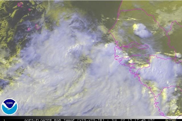
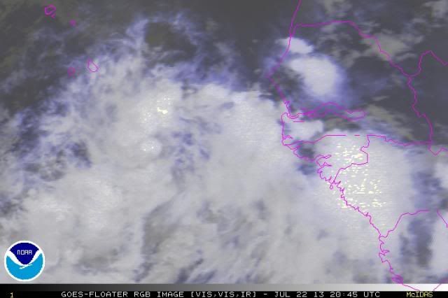
Impressive for any month (let alone July!) to be just coming off the African coast and have great symmetry and have this good convection with banding and now convection blowing up over the center. Here's the last 2 RGB images.


0 likes
-
Aric Dunn
- Category 5
- Posts: 21228
- Age: 41
- Joined: Sun Sep 19, 2004 9:58 pm
- Location: Ready for the Chase.
- Contact:
very impressive actually. well on its way. im very surprised they put a floater over it... though images are every 3 hours better then nothing.
0 likes
Note: If I make a post that is brief. Please refer back to previous posts for the analysis or reasoning. I do not re-write/qoute what my initial post said each time.
If there is nothing before... then just ask
Space & Atmospheric Physicist, Embry-Riddle Aeronautical University,
I believe the sky is falling...
If there is nothing before... then just ask
Space & Atmospheric Physicist, Embry-Riddle Aeronautical University,
I believe the sky is falling...
-
cycloneye
- Admin
- Posts: 139067
- Age: 67
- Joined: Thu Oct 10, 2002 10:54 am
- Location: San Juan, Puerto Rico
Re: ATL: INVEST 98L - Discussion
Yes Aric,very impressive indeed.

0 likes
Visit the Caribbean-Central America Weather Thread where you can find at first post web cams,radars
and observations from Caribbean basin members Click Here
and observations from Caribbean basin members Click Here

-
meriland23

- Category 5
- Posts: 1239
- Age: 36
- Joined: Mon Aug 29, 2011 9:29 pm
Re: ATL: INVEST 98L - Discussion
Hard to say if it will or wont strengthen after it becomes a TS this far out..
0 likes
The posts in this forum are NOT official forecast and should not be used as such. They are just the opinion of the poster and may or may not be backed by sound meteorological data. They are NOT endorsed by any professional institution or storm2k.org. For official information, please refer to the NHC and NWS products.
-
meriland23
- Category 5
- Posts: 1239
- Age: 36
- Joined: Mon Aug 29, 2011 9:29 pm
question is whether the sea will be more or less conductive than Chantal had.. and the speed it moves. Chantal outran its own self..
0 likes
The posts in this forum are NOT official forecast and should not be used as such. They are just the opinion of the poster and may or may not be backed by sound meteorological data. They are NOT endorsed by any professional institution or storm2k.org. For official information, please refer to the NHC and NWS products.
-
TheStormExpert
- Category 5
- Posts: 8487
- Age: 30
- Joined: Wed Feb 16, 2011 5:38 pm
- Location: Palm Beach Gardens, FL
Re:
RL3AO wrote:Can see it becoming a 35 to 45kt TS in the next three days. After that though, I can't see it strengthening. Survival will be enough of a challenge.
Is the only real problem going to be cooler waters? Or is shear, and dry air going to be a problem too?
Couples days ago some people were saying how water temps are never an issue in the Atlantic when it comes to TC development.
0 likes
The following post is NOT an official forecast and should not be used as such. It is just the opinion of the poster and may or may not be backed by sound meteorological data. It is NOT endorsed by storm2k.org.
-
northjaxpro

- S2K Supporter
- Posts: 8900
- Joined: Mon Sep 27, 2010 11:21 am
- Location: Jacksonville, FL
0 likes
NEVER, EVER SAY NEVER in the tropics and weather in general, and most importantly, with life itself!!
________________________________________________________________________________________
Fay 2008 Beryl 2012 Debby 2012 Colin 2016 Hermine 2016 Julia 2016 Matthew 2016 Irma 2017 Dorian 2019
________________________________________________________________________________________
Fay 2008 Beryl 2012 Debby 2012 Colin 2016 Hermine 2016 Julia 2016 Matthew 2016 Irma 2017 Dorian 2019
-
TheStormExpert
- Category 5
- Posts: 8487
- Age: 30
- Joined: Wed Feb 16, 2011 5:38 pm
- Location: Palm Beach Gardens, FL
Re:
meriland23 wrote:question is whether the sea will be more or less conductive than Chantal had.. and the speed it moves. Chantal outran its own self..
That has been the problem with multiple storms out in the MDR these past 2 seasons. Makes me question some things about this season.
0 likes
The following post is NOT an official forecast and should not be used as such. It is just the opinion of the poster and may or may not be backed by sound meteorological data. It is NOT endorsed by storm2k.org.
-
SFLcane

- S2K Supporter
- Posts: 9606
- Age: 46
- Joined: Sat Jun 05, 2010 1:44 pm
- Location: Lake Worth Florida
Re: ATL: INVEST 98L - Discussion
Last edited by tolakram on Mon Jul 22, 2013 7:20 pm, edited 1 time in total.
Reason: removed direct embed of image
Reason: removed direct embed of image
0 likes
-
northjaxpro
- S2K Supporter
- Posts: 8900
- Joined: Mon Sep 27, 2010 11:21 am
- Location: Jacksonville, FL
It looks great this evening. Large moisture envelope with a healthy outflow. Percentages will probably increase in the TWO I am confident about that.
0 likes
NEVER, EVER SAY NEVER in the tropics and weather in general, and most importantly, with life itself!!
________________________________________________________________________________________
Fay 2008 Beryl 2012 Debby 2012 Colin 2016 Hermine 2016 Julia 2016 Matthew 2016 Irma 2017 Dorian 2019
________________________________________________________________________________________
Fay 2008 Beryl 2012 Debby 2012 Colin 2016 Hermine 2016 Julia 2016 Matthew 2016 Irma 2017 Dorian 2019
Who is online
Users browsing this forum: No registered users and 109 guests