WPAC: UTOR - Post-Tropical

Moderator: S2k Moderators

Message
Author
vrif
Category 1
Category 1
Posts: 282
Joined: Sun Jun 09, 2013 10:51 pm

Re: WPAC: UTOR - Typhoon (Labuyo PAGASA)

#301 Postby vrif » Mon Aug 12, 2013 3:09 am

TRMM 0811 0622Z pass

Also from HKO..

Code: Select all

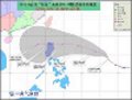
THE STANDBY SIGNAL, NO. 1, WAS ISSUED AT 4:05 P.M.

DISPATCHED BY HONG KONG OBSERVATORY AT 16:05 HKT ON 12.08.2013

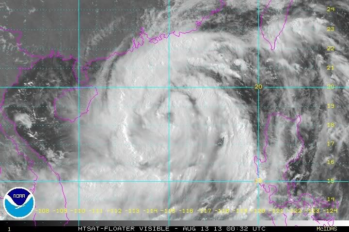
At 4 p.m., Severe Typhoon Utor was estimated to be about 710 kilometres southeast of Hong Kong (near 17.5 degrees north 118.6 degrees east) and is forecast to move west-northwest at about 22 kilometres per hour across the central part of the South China Sea, in the general direction of the western coast of Guangdong.

As Utor is still at some distance from Hong Kong, local winds will not strengthen significantly before midnight. According to the present forecast track, Utor will gradually edge closer to the south China coast tomorrow. Local winds will strengthen progressively. The Observatory will consider issuing the Strong Wind Signal, No. 3, tomorrow morning. Under the influence of the outer rainband of Utor, local weather will deteriorate tomorrow with heavy squally showers and rough seas.


Image
Image
0 likes   

User avatar
Filipinas50
Tropical Depression
Tropical Depression
Posts: 77
Age: 58
Joined: Tue May 28, 2013 2:07 am
Location: Planet Earth

Re: WPAC: UTOR - Typhoon (Labuyo PAGASA)

#302 Postby Filipinas50 » Mon Aug 12, 2013 3:31 am

Latest Image from DOST Aparri Doppler Radar Station Shows Isolated Moderate to Heavy Rains in Northern Luzon from Typhoon Utor's Effect @ 1345 Hours ...

Image
0 likes   
RETIRED FROM THE 9-5 RAT RACE

User avatar
xtyphooncyclonex
Category 5
Category 5
Posts: 3688
Age: 22
Joined: Sat Dec 08, 2012 9:07 am
Location: Cebu City
Contact:

Re: WPAC: UTOR - Typhoon (Labuyo PAGASA)

#303 Postby xtyphooncyclonex » Mon Aug 12, 2013 5:50 am

Super Typhoon 'Utor' (Labuyo) near peak intensity.

Personal Estimate: 145 kts (270 km/hr)

Image
0 likes   
REMINDER: My opinions that I, or any other NON Pro-Met in this forum, are unofficial. Please do not take my opinions as an official forecast and warning. I am NOT a meteorologist. Following my forecasts blindly may lead to false alarm, danger and risk if official forecasts from agencies are ignored.

RobWESTPACWX
WestPACMet
WestPACMet
Posts: 1616
Joined: Fri Sep 17, 2010 2:26 am
Location: Tokyo, Japan
Contact:

Re: WPAC: UTOR - Typhoon (Labuyo PAGASA)

#304 Postby RobWESTPACWX » Mon Aug 12, 2013 6:32 am

Baguio City and Casiguran Damage

Image

Image

Below is the GFS output for Wednesday at 06Z as well. I think its still a little far west

Image

Lastly Im NHKWORLD today, talking about the storm. Will have video next hour 20 after the hour.

Showing the accumulation forecast last hour.

Image
0 likes   
Satellites, Charts and Forecasting tools for East Asia at WESTERNPACIFICWEATHER.COM

CrazyC83
Professional-Met
Professional-Met
Posts: 33393
Joined: Tue Mar 07, 2006 11:57 pm
Location: Deep South, for the first time!

#305 Postby CrazyC83 » Mon Aug 12, 2013 9:29 am

It definitely appears the structure was disrupted over land. Probably about 80 kt right now based on the Dvorak estimates (leaning low due to the larger size and coming off land).
0 likes   

RobWESTPACWX
WestPACMet
WestPACMet
Posts: 1616
Joined: Fri Sep 17, 2010 2:26 am
Location: Tokyo, Japan
Contact:

Re: WPAC: UTOR - Typhoon (Labuyo PAGASA)

#306 Postby RobWESTPACWX » Mon Aug 12, 2013 10:18 am

Latest track from JTWC, a little farther west

Image

JMA with a similar forecast.

Image
0 likes   
Satellites, Charts and Forecasting tools for East Asia at WESTERNPACIFICWEATHER.COM

vrif
Category 1
Category 1
Posts: 282
Joined: Sun Jun 09, 2013 10:51 pm

Re: WPAC: UTOR - Typhoon (Labuyo PAGASA)

#307 Postby vrif » Mon Aug 12, 2013 10:46 am

The 1358Z ASCAT pass.
Image
0 likes   

CrazyC83
Professional-Met
Professional-Met
Posts: 33393
Joined: Tue Mar 07, 2006 11:57 pm
Location: Deep South, for the first time!

#308 Postby CrazyC83 » Mon Aug 12, 2013 11:35 am

My best analysis on how the Hong Kong signals are:

Signal 1 - Pre-alert or similar to a Wind Advisory/Small Craft Advisory

Signal 3 - similar to a Tropical Storm Watch

Signal 8 - similar to a Tropical Storm Warning (either with or without a Hurricane Watch attached)

Signals 9 and 10 - similar to a Hurricane Warning
0 likes   

RobWESTPACWX
WestPACMet
WestPACMet
Posts: 1616
Joined: Fri Sep 17, 2010 2:26 am
Location: Tokyo, Japan
Contact:

Re: WPAC: UTOR - Typhoon (Labuyo PAGASA)

#309 Postby RobWESTPACWX » Mon Aug 12, 2013 11:39 am

:uarrow: not to bad of a analysis

I just put together a video update on Utor, plus a lot of other information. Its actually rather beefy today.

[youtube]http://www.youtube.com/watch?v=Kuwd7PJJDCg[/youtube]
0 likes   
Satellites, Charts and Forecasting tools for East Asia at WESTERNPACIFICWEATHER.COM

vrif
Category 1
Category 1
Posts: 282
Joined: Sun Jun 09, 2013 10:51 pm

Re:

#310 Postby vrif » Mon Aug 12, 2013 12:25 pm

CrazyC83 wrote:My best analysis on how the Hong Kong signals are:

Signal 1 - Pre-alert or similar to a Wind Advisory/Small Craft Advisory

Signal 3 - similar to a Tropical Storm Watch

Signal 8 - similar to a Tropical Storm Warning (either with or without a Hurricane Watch attached)

Signals 9 and 10 - similar to a Hurricane Warning


Here is a description of the signals. Residents look forward to signal 8, because they don't have to go to school or work. Then they will go out and enjoy themselves.

http://www.hko.gov.hk/publica/gen_pub/tcws.pdf

1: A tropical cyclone is centred within about 800 kilometres
(km) of Hong Kong and may affect the territory.

3: Strong wind is expected or blowing generally in Hong Kong
near sea level, with a sustained speed of 41-62 kilometres per
hour (km/h), and gusts which may exceed 110 km/h, and the
wind condition is expected to persist.

8: Gale or storm force wind is expected or blowing generally in
Hong Kong near sea level, with a sustained wind speed of
63-117 km/h from the quarter indicated and gusts which may
exceed 180 km/h, and the wind condition is expected to
persist.

9: Gale or storm force wind is increasing or expected to increase
significantly in strength.

10: Hurricane force wind is expected or blowing with sustained
speed reaching upwards from 118 km/h and gusts that may
exceed 220 km/h.
0 likes   

vrif
Category 1
Category 1
Posts: 282
Joined: Sun Jun 09, 2013 10:51 pm

Re: WPAC: UTOR - Typhoon (Labuyo PAGASA)

#311 Postby vrif » Mon Aug 12, 2013 7:24 pm

Outerbands on the radar
Image

Image
0 likes   

CrazyC83
Professional-Met
Professional-Met
Posts: 33393
Joined: Tue Mar 07, 2006 11:57 pm
Location: Deep South, for the first time!

Re: Re:

#312 Postby CrazyC83 » Mon Aug 12, 2013 7:38 pm

vrif wrote:
CrazyC83 wrote:My best analysis on how the Hong Kong signals are:

Signal 1 - Pre-alert or similar to a Wind Advisory/Small Craft Advisory

Signal 3 - similar to a Tropical Storm Watch

Signal 8 - similar to a Tropical Storm Warning (either with or without a Hurricane Watch attached)

Signals 9 and 10 - similar to a Hurricane Warning


Here is a description of the signals. Residents look forward to signal 8, because they don't have to go to school or work. Then they will go out and enjoy themselves.

http://www.hko.gov.hk/publica/gen_pub/tcws.pdf

1: A tropical cyclone is centred within about 800 kilometres
(km) of Hong Kong and may affect the territory.

3: Strong wind is expected or blowing generally in Hong Kong
near sea level, with a sustained speed of 41-62 kilometres per
hour (km/h), and gusts which may exceed 110 km/h, and the
wind condition is expected to persist.

8: Gale or storm force wind is expected or blowing generally in
Hong Kong near sea level, with a sustained wind speed of
63-117 km/h from the quarter indicated and gusts which may
exceed 180 km/h, and the wind condition is expected to
persist.

9: Gale or storm force wind is increasing or expected to increase
significantly in strength.

10: Hurricane force wind is expected or blowing with sustained
speed reaching upwards from 118 km/h and gusts that may
exceed 220 km/h.


Why would they enjoy themselves? It would be too dangerous to go anywhere once you get that far, certainly to high 8 or 9 level...
0 likes   

vrif
Category 1
Category 1
Posts: 282
Joined: Sun Jun 09, 2013 10:51 pm

Re: Re:

#313 Postby vrif » Mon Aug 12, 2013 8:33 pm

CrazyC83 wrote:Why would they enjoy themselves? It would be too dangerous to go anywhere once you get that far, certainly to high 8 or 9 level...


Essentially it becomes free time. Some restaurants, Karaoke places, and Cinema's are open. MTR is run at a reduced service level, so people can still move around the city. Thankfully most people will heed the warning and head home.
0 likes   

RL3AO
Moderator-Pro Met
Moderator-Pro Met
Posts: 16308
Joined: Thu Jun 14, 2007 10:03 pm
Location: NC

#314 Postby RL3AO » Mon Aug 12, 2013 8:44 pm

Utor is starting to see again

Image
0 likes   

Typhoon Hunter
WesternPacificWeather.com
Posts: 1215
Age: 40
Joined: Wed Oct 11, 2006 11:37 am
Location: Hong Kong
Contact:

Re: Re:

#315 Postby Typhoon Hunter » Mon Aug 12, 2013 9:43 pm

CrazyC83 wrote:Why would they enjoy themselves? It would be too dangerous to go anywhere once you get that far, certainly to high 8 or 9 level...


Typhoons are part of the culture here in HK and in other parts of the Wpac. Usually the typhoons blow past to the south, we get some gales, everyone has a day off and is happy and no major problems. There's even a bar in Wanchai called Typhoon which offers free drinks deal when it's T8!

However Hong Kong hasn't been properly eyewalled for many years so I do worry when a serious storm moves in, and that will happen sooner or later, some people will treat it as a game. Vicente last year was a swipe, yes it was a T10 but it was nowhere near a proper eyewalling, so HK really dodged a bullet then.

Back to Utor, looks like we're about to get squalled here. I'm going to catch a rather bumpy ferry to Zhuhai this afternoon and then proceed west up the coast to try and catch Utor in Guangdong!
0 likes   
James - Documenting typhoons...

http://www.youtube.com/TyphoonHunter

Alyono
Professional-Met
Professional-Met
Posts: 6961
Joined: Fri Apr 26, 2013 3:52 pm
Location: Texas Coast

#316 Postby Alyono » Mon Aug 12, 2013 9:52 pm

looks like it is about 105KT again. This reintensified far faster than I expected it to
0 likes   

RL3AO
Moderator-Pro Met
Moderator-Pro Met
Posts: 16308
Joined: Thu Jun 14, 2007 10:03 pm
Location: NC

Re:

#317 Postby RL3AO » Mon Aug 12, 2013 9:59 pm

Alyono wrote:looks like it is about 105KT again. This reintensified far faster than I expected it to


Eye has warmed very quickly. Looks like black (BD) surrounds the eye now too.
0 likes   

Sanibel
Category 5
Category 5
Posts: 10348
Joined: Mon Aug 30, 2004 11:06 pm
Location: Offshore SW Florida

Re: WPAC: UTOR - Typhoon (Labuyo PAGASA)

#318 Postby Sanibel » Mon Aug 12, 2013 10:08 pm

Strengthening from the satellite look of it.
0 likes   

vrif
Category 1
Category 1
Posts: 282
Joined: Sun Jun 09, 2013 10:51 pm

Re: WPAC: UTOR - Typhoon (Labuyo PAGASA)

#319 Postby vrif » Mon Aug 12, 2013 10:16 pm

JTWC is forecasting Utor to re-intensify into a CAT 4.
Image
0 likes   

RobWESTPACWX
WestPACMet
WestPACMet
Posts: 1616
Joined: Fri Sep 17, 2010 2:26 am
Location: Tokyo, Japan
Contact:

Re: WPAC: UTOR - Typhoon (Labuyo PAGASA)

#320 Postby RobWESTPACWX » Mon Aug 12, 2013 10:18 pm

Theres a place where you can get free drinks at T8?? HMM thats a fun business idea.
0 likes   
Satellites, Charts and Forecasting tools for East Asia at WESTERNPACIFICWEATHER.COM


Return to “2013”

Who is online

Users browsing this forum: No registered users and 19 guests