The following is not an official forecast and should not be used as such. It is just the opinion of the poster and may or may not be backed by sound meteorological data. It is not endorsed by any professional institution, including Storm2k.org. For official information, please see the NWS products.
Now it looks like it is being affected by wind shear. Does anyone else notice this?
WPAC: UNALA - Post-Tropical
Moderator: S2k Moderators
-
hurricanes1234
- Category 5

- Posts: 2903
- Joined: Sat Jul 28, 2012 6:19 pm
- Location: Trinidad and Tobago
Re: CPAC: INVEST 90C
0 likes
PLEASE NOTE: With the exception of information from weather agencies that I may copy and paste here, my posts will NEVER be official, since I am NOT a meteorologist. They are solely my amateur opinion, and may or may not be accurate. Therefore, please DO NOT use them as official details, particularly when making important decisions. Thank you.
-
jaguarjace

- Category 4

- Posts: 975
- Age: 29
- Joined: Sat Jun 11, 2011 7:38 am
- Location: Khon Kaen, Thailand
Re: CPAC: INVEST 90C
TCFA

WTPN21 PHNC 151430
MSGID/GENADMIN/JOINT TYPHOON WRNCEN PEARL HARBOR HI//
SUBJ/TROPICAL CYCLONE FORMATION ALERT//
RMKS/
1. FORMATION OF A SIGNIFICANT TROPICAL CYCLONE IS POSSIBLE WITHIN
160 NM EITHER SIDE OF A LINE FROM 12.4N 158.4W TO 13.8N 167.2W
WITHIN THE NEXT 06 TO 24 HOURS. AVAILABLE DATA DOES NOT JUSTIFY
ISSUANCE OF NUMBERED TROPICAL CYCLONE WARNINGS AT THIS TIME. WINDS
IN THE AREA ARE ESTIMATED TO BE 15 TO 20 KNOTS. METSAT IMAGERY AT
151400Z INDICATES THAT A CIRCULATION CENTER IS LOCATED NEAR 12.3N
159.1W. THE SYSTEM IS MOVING WESTWARD AT 16 KNOTS.
2. REMARKS: AN AREA OF CONVECTION IS LOCATED NEAR 12.3N 159.1W,
APPROXIMATELY 500NM SOUTH-SOUTHWEST OF HILO, HAWAII. ANIMATED
INFRARED SATELLITE IMAGERY DEPICTS A CONSOLIDATING LOW-LEVEL
CIRCULATION CENTER (LLCC) WITH PERSISTENT DEEP CONVECTION OVER THE
LLCC. A 151226Z NOAA-19 89GHZ IMAGE INDICATES DEEP CONVECTIVE
BANDING OVER THE EASTERN SEMI-CIRCLE WRAPPING INTO THE NORTH
QUADRANT WITH SHALLOW, BROAD BANDING ELSEWHERE. RECENT SCATTEROMETER
DATA INDICATES THAT THE LLCC IS LOCATED WITHIN AN AREA OF SHARP
TROUGHING WITH NO INDICATION OF A SURFACE REFLECTION; HOWEVER,
STRONG MID-LEVEL TURNING IS EVIDENT WITH FORMATIVE BANDING. UPPER-
LEVEL CONDITIONS ARE MARGINAL WITH MODERATE TO STRONG (20 TO 30
KNOTS) VERTICAL WIND SHEAR OFFSET BY FAIR EQUATORWARD OUTFLOW.
MAXIMUM SUSTAINED SURFACE WINDS ARE ESTIMATED AT 15 TO 20 KNOTS.
MINIMUM SEA LEVEL PRESSURE IS ESTIMATED TO BE NEAR 1006 MB. THE
POTENTIAL FOR THE DEVELOPMENT OF A SIGNIFICANT TROPICAL CYCLONE
WITHIN THE NEXT 24 HOURS IS HIGH.
3. THIS ALERT WILL BE REISSUED, UPGRADED TO WARNING OR CANCELLED BY
161430Z.//
0 likes
Owner of the Tropical Archive YouTube channel
Web Developer at Force Thirteen
Twitter/X : @force13_support
Web Developer at Force Thirteen
Twitter/X : @force13_support
-
Yellow Evan

- Professional-Met

- Posts: 15951
- Age: 25
- Joined: Fri Jul 15, 2011 12:48 pm
- Location: Henderson, Nevada/Honolulu, HI
- Contact:
2. An area of low pressure centered about 775 miles south-southwest of Kauai is moving west near 15 mph. Outflow from the developing system described above is making conditions less conducive for further development, and system organization has diminished over the past six to twelve hours. This system has a medium chance, 30 percent, of becoming a tropical cyclone during the next 48 hours.
0 likes
-
Yellow Evan
- Professional-Met
- Posts: 15951
- Age: 25
- Joined: Fri Jul 15, 2011 12:48 pm
- Location: Henderson, Nevada/Honolulu, HI
- Contact:


-
Iceman56

Re: CPAC: INVEST 90C
Dvorak at 2.5...maybe they don't want to upgrade since it will enter the wpac soon?
0 likes
Remember, all of my post aren't official. For official warnings and discussions, Please refer to your local NWS products...
NWS for the Western Pacific
https://www.weather.gov/gum/
NWS for the Western Pacific
https://www.weather.gov/gum/
-
Yellow Evan
- Professional-Met
- Posts: 15951
- Age: 25
- Joined: Fri Jul 15, 2011 12:48 pm
- Location: Henderson, Nevada/Honolulu, HI
- Contact:
Re: CPAC: INVEST 90C
euro6208 wrote:Dvorak at 2.5...maybe they don't want to upgrade since it will enter the wpac soon?
That did not stop them from upgrading Pewa or in 2009, Two-c, which were near the dateline.
0 likes
-
cycloneye

- Admin

- Posts: 139025
- Age: 67
- Joined: Thu Oct 10, 2002 10:54 am
- Location: San Juan, Puerto Rico
Re: CPAC: INVEST 90C
BEGIN
CPHC_ATCF
invest_RENUMBER_cp902013_cp022013.ren
FSTDA
R
U
040
010
0000
201308181523
NONE
NOTIFY=ATRP
CPHC_ATCF
invest_RENUMBER_cp902013_cp022013.ren
FSTDA
R
U
040
010
0000
201308181523
NONE
NOTIFY=ATRP
0 likes
Visit the Caribbean-Central America Weather Thread where you can find at first post web cams,radars
and observations from Caribbean basin members Click Here
and observations from Caribbean basin members Click Here
-
Yellow Evan
- Professional-Met
- Posts: 15951
- Age: 25
- Joined: Fri Jul 15, 2011 12:48 pm
- Location: Henderson, Nevada/Honolulu, HI
- Contact:
-
supercane4867
- Category 5
- Posts: 4966
- Joined: Wed Nov 14, 2012 10:43 am
Re: CPAC: INVEST 90C
Very sheard TS at the moment, hard to belive JMA will admit it once crosses 180°

0 likes
-
Yellow Evan
- Professional-Met
- Posts: 15951
- Age: 25
- Joined: Fri Jul 15, 2011 12:48 pm
- Location: Henderson, Nevada/Honolulu, HI
- Contact:

-
cycloneye
- Admin
- Posts: 139025
- Age: 67
- Joined: Thu Oct 10, 2002 10:54 am
- Location: San Juan, Puerto Rico
Re: CPAC: INVEST 90C
Tropical storm Unala forms well west southwest of Hawaii
SUMMARY OF 500 PM HST...0300 UTC...INFORMATION
LOCATION: 17.1N 178.3W
ABOUT 1360 MI: 2190 KM W OF HONOLULU HAWAII
ABOUT 1275 MI: 2050 KM WSW OF LIHUE HAWAII
MAXIMUM SUSTAINED WINDS: 40 MPH: 65 KM/H
PRESENT MOVEMENT: W OR 270 DEGREES AT 21 MPH: 33 KM/H
MINIMUM CENTRAL PRESSURE: 998 MB or 29.47 INCHES
0 likes
Visit the Caribbean-Central America Weather Thread where you can find at first post web cams,radars
and observations from Caribbean basin members Click Here
and observations from Caribbean basin members Click Here
-
hurricanes1234
- Category 5
- Posts: 2903
- Joined: Sat Jul 28, 2012 6:19 pm
- Location: Trinidad and Tobago
Re: CPAC: INVEST 90C
When last did we have two cPac storms (with cPac names) coexisting like this?
Edit: Even though Pewa is in the wPac, it still carries its cPac name, and Unala is existing simultaneously with it, although in a different basin.
Edit: Even though Pewa is in the wPac, it still carries its cPac name, and Unala is existing simultaneously with it, although in a different basin.
Last edited by hurricanes1234 on Sun Aug 18, 2013 10:04 pm, edited 1 time in total.
0 likes
PLEASE NOTE: With the exception of information from weather agencies that I may copy and paste here, my posts will NEVER be official, since I am NOT a meteorologist. They are solely my amateur opinion, and may or may not be accurate. Therefore, please DO NOT use them as official details, particularly when making important decisions. Thank you.
-
cycloneye
- Admin
- Posts: 139025
- Age: 67
- Joined: Thu Oct 10, 2002 10:54 am
- Location: San Juan, Puerto Rico
Re: CPAC: UNALA - Tropical Storm
TROPICAL STORM UNALA DISCUSSION NUMBER 1
NWS CENTRAL PACIFIC HURRICANE CENTER HONOLULU HI CP022013
500 PM HST SUN AUG 18 2013
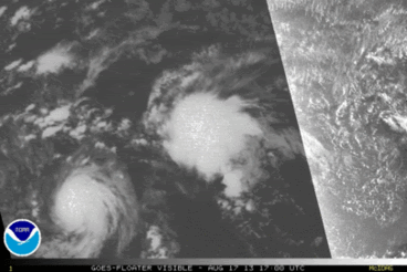
GOES VISIBLE IMAGERY AT 2330Z AND A 0020Z ASCAT PASS DEMONSTRATED
THAT THE SUSPECT AREA FORMERLY KNOWN AS INVEST 90C WAS ACTUALLY
TROPICAL STORM UNALA. ASCAT SHOWED A SHARP TROUGH WITH A RAGGED 30
NM SWATH OF TROPICAL STORM FORCE WINDS ACROSS NORTHEAST AND
NORTHWEST SECTIONS...BUT NO CLOSED CIRCULATION CENTER.
HOWEVER...GOES VISIBLE IMAGERY AT 2330Z SHOWED A LOW LEVEL
CIRCULATION CENTER...LLCC...POPPING OUT TO THE WEST SOUTHWEST OF
DEEP CONVECTION. THE COMBINATION OF THE TWO DATA SETS COMPELLED US
TO UPGRADE THIS SYSTEM IN SHORT ORDER.
INITIAL STRENGTH IS SET AT 35 KT BASED MAINLY ON SCATTEROMETER DATA.
FIXES FROM CPHC AND JTWC INDICATED 30 KT STRENGTH...WHILE SAB ALONE
HAD THIS SYSTEM STRONGER AT 35 KT. THERE WERE A FEW STRONGER WIND
BARBS WITHIN THE ASCAT PASS...BUT WITH THE EMERGENCE OF THE LLCC IT
IS LIKELY THIS SYSTEM IS ACTUALLY PAST ITS PEAK...MAKING 35 KT SEEM
REASONABLE. SHIPS SLOWLY STRENGTHENS UNALA THROUGH 120
HOURS...MAKING IT A 50 KT TROPICAL STORM AT THE END OF 5 DAYS.
HOWEVER...INTERFERENCE FROM TROPICAL STORM PEWA OR ITS REMNANTS
SHOULD HINDER DEVELOPMENT. SHIPS SEEMS TO PARAMETERIZE THIS BY
HAVING UNALA PASS THROUGH RATHER BRUTAL SHEAR BEYOND 12 HOURS...BUT
FAILS TO WEAKEN THE SYSTEM APPROPRIATELY. WE WILL KEEP UNALA AT
MARGINAL TROPICAL STORM STRENGTH THROUGH 48 HOURS...THEN WEAKEN IT
AFTERWARD AS A NOD TO THE FORECAST SHEAR.
INITIAL MOTION IS TOWARD THE WEST AT 18 KT ALONG THE SOUTH SIDE OF A
BROAD SUBTROPICAL RIDGE. THIS TRACK WILL GRADUALLY BECOME
NORTHWESTERLY IN THE 36 TO 48 HOUR TIMEFRAME AS UNALA BEGINS TO
GAIN LATITUDE ALONG THE WESTERN LIMB OF THE RIDGE. TRACK GUIDANCE
IS TIGHTLY PACKED IN A SIMILAR MANNER...BUT WITH A QUICKER SWING TO
THE NORTH. INITIAL MOTION AND THE PROXIMITY OF PEWA KEEPS THE
FORECAST TRACK WITHIN THE LEFT HALF OF THE TRACK GUIDANCE ENVELOPE.
FORECAST POSITIONS AND MAX WINDS
INIT 19/0300Z 17.1N 178.3W 35 KT 40 MPH
12H 19/1200Z 17.2N 178.9E 35 KT 40 MPH
24H 20/0000Z 17.6N 175.3E 35 KT 40 MPH
36H 20/1200Z 18.4N 172.1E 35 KT 40 MPH
48H 21/0000Z 19.9N 169.0E 35 KT 40 MPH
72H 22/0000Z 24.0N 163.9E 30 KT 35 MPH
96H 23/0000Z 29.5N 160.6E 30 KT 35 MPH
120H 24/0000Z 34.9N 158.8E 30 KT 35 MPH...POST-TROP/REMNT LOW
$$
FORECASTER POWELL
NWS CENTRAL PACIFIC HURRICANE CENTER HONOLULU HI CP022013
500 PM HST SUN AUG 18 2013
GOES VISIBLE IMAGERY AT 2330Z AND A 0020Z ASCAT PASS DEMONSTRATED
THAT THE SUSPECT AREA FORMERLY KNOWN AS INVEST 90C WAS ACTUALLY
TROPICAL STORM UNALA. ASCAT SHOWED A SHARP TROUGH WITH A RAGGED 30
NM SWATH OF TROPICAL STORM FORCE WINDS ACROSS NORTHEAST AND
NORTHWEST SECTIONS...BUT NO CLOSED CIRCULATION CENTER.
HOWEVER...GOES VISIBLE IMAGERY AT 2330Z SHOWED A LOW LEVEL
CIRCULATION CENTER...LLCC...POPPING OUT TO THE WEST SOUTHWEST OF
DEEP CONVECTION. THE COMBINATION OF THE TWO DATA SETS COMPELLED US
TO UPGRADE THIS SYSTEM IN SHORT ORDER.
INITIAL STRENGTH IS SET AT 35 KT BASED MAINLY ON SCATTEROMETER DATA.
FIXES FROM CPHC AND JTWC INDICATED 30 KT STRENGTH...WHILE SAB ALONE
HAD THIS SYSTEM STRONGER AT 35 KT. THERE WERE A FEW STRONGER WIND
BARBS WITHIN THE ASCAT PASS...BUT WITH THE EMERGENCE OF THE LLCC IT
IS LIKELY THIS SYSTEM IS ACTUALLY PAST ITS PEAK...MAKING 35 KT SEEM
REASONABLE. SHIPS SLOWLY STRENGTHENS UNALA THROUGH 120
HOURS...MAKING IT A 50 KT TROPICAL STORM AT THE END OF 5 DAYS.
HOWEVER...INTERFERENCE FROM TROPICAL STORM PEWA OR ITS REMNANTS
SHOULD HINDER DEVELOPMENT. SHIPS SEEMS TO PARAMETERIZE THIS BY
HAVING UNALA PASS THROUGH RATHER BRUTAL SHEAR BEYOND 12 HOURS...BUT
FAILS TO WEAKEN THE SYSTEM APPROPRIATELY. WE WILL KEEP UNALA AT
MARGINAL TROPICAL STORM STRENGTH THROUGH 48 HOURS...THEN WEAKEN IT
AFTERWARD AS A NOD TO THE FORECAST SHEAR.
INITIAL MOTION IS TOWARD THE WEST AT 18 KT ALONG THE SOUTH SIDE OF A
BROAD SUBTROPICAL RIDGE. THIS TRACK WILL GRADUALLY BECOME
NORTHWESTERLY IN THE 36 TO 48 HOUR TIMEFRAME AS UNALA BEGINS TO
GAIN LATITUDE ALONG THE WESTERN LIMB OF THE RIDGE. TRACK GUIDANCE
IS TIGHTLY PACKED IN A SIMILAR MANNER...BUT WITH A QUICKER SWING TO
THE NORTH. INITIAL MOTION AND THE PROXIMITY OF PEWA KEEPS THE
FORECAST TRACK WITHIN THE LEFT HALF OF THE TRACK GUIDANCE ENVELOPE.
FORECAST POSITIONS AND MAX WINDS
INIT 19/0300Z 17.1N 178.3W 35 KT 40 MPH
12H 19/1200Z 17.2N 178.9E 35 KT 40 MPH
24H 20/0000Z 17.6N 175.3E 35 KT 40 MPH
36H 20/1200Z 18.4N 172.1E 35 KT 40 MPH
48H 21/0000Z 19.9N 169.0E 35 KT 40 MPH
72H 22/0000Z 24.0N 163.9E 30 KT 35 MPH
96H 23/0000Z 29.5N 160.6E 30 KT 35 MPH
120H 24/0000Z 34.9N 158.8E 30 KT 35 MPH...POST-TROP/REMNT LOW
$$
FORECASTER POWELL
0 likes
Visit the Caribbean-Central America Weather Thread where you can find at first post web cams,radars
and observations from Caribbean basin members Click Here
and observations from Caribbean basin members Click Here
-
Yellow Evan
- Professional-Met
- Posts: 15951
- Age: 25
- Joined: Fri Jul 15, 2011 12:48 pm
- Location: Henderson, Nevada/Honolulu, HI
- Contact:
Re: CPAC: INVEST 90C
hurricanes1234 wrote:When last did we have two cPac storms (with cPac names) coexisting like this?
Edit: Even though Pewa is in the wPac, it still carries its cPac name, and Unala is existing simultaneously with it, although in a different basin.
2002.
0 likes
Who is online
Users browsing this forum: No registered users and 31 guests