

What's interesting is that, the wave that produced this system also will likely produce a storm in the Epac and very close to LLc just south of Galveston Tx.
Season seems to be cranking up.
Back to 95L, sure looks like a WNW movement at a decent clip, steering setup pretty clear.
http://tropic.ssec.wisc.edu/real-time/a ... g8dlm2.GIF
ATL: FERNAND - Renmants - Discussion
Moderator: S2k Moderators
Re: ATL: INVEST 95L - Discussion
0 likes
The following post is NOT an official forecast and should not be used as such. It is just the opinion of the poster and may or may not be backed by sound meteorological data. It is NOT endorsed by any professional institution including storm2k.org For Official Information please refer to the NHC and NWS products.
-
cycloneye

- Admin

- Posts: 139307
- Age: 67
- Joined: Thu Oct 10, 2002 10:54 am
- Location: San Juan, Puerto Rico
Re: ATL: INVEST 95L - Discussion
Plane this afternoon or an ASCAT pass will confirm if 95L is a TD or a TS.

0 likes
Visit the Caribbean-Central America Weather Thread where you can find at first post web cams,radars
and observations from Caribbean basin members Click Here
and observations from Caribbean basin members Click Here
-
weatherwindow

- Category 4

- Posts: 904
- Joined: Mon Sep 20, 2004 9:48 am
- Location: key west/ft lauderdale
Re: ATL: INVEST 95L - Discussion
As of 1115EDT, based on low cloud motion and extrapolation, making the incipient LLC at ~19.8N 94.8W...if my eyeballing is correct, it is gaining a bit of latitude vis-a-vis the 12Z atcf initialization. This motion appears, as Aloyno suggested, to be at least 295deg, perhaps as much as 300deg. This could provide it with additional time over water prior to landfall. Obviously, this assumes my assessment of the location, given the cloud cover, is correct....Grtz from KW, Rich
http://www.ssd.noaa.gov/PS/TROP/floater ... oater.html
The opinions expressed above are not to be confused with the official assessments and forecasts of the NOAA, the NWS or the NHC. These opinions are those of an amateur and are not endorsed by the above agencies or Storm2K. Please consult the NWS, the NHC and local emergency mgmt for official advices
Last edited by weatherwindow on Sun Aug 25, 2013 11:04 am, edited 1 time in total.
0 likes

-
HurricaneDREW92
- Category 1

- Posts: 320
- Age: 25
- Joined: Sun Jul 28, 2013 11:56 am
- Location: Boston, MA
Re: ATL: INVEST 95L - Discussion
Ill top this one out at 65-70mph at landfall Monday at 4pm. Think we'll see a 35/40kt Fernand at 5pm.
If I had to guess based on satellite alone, I'd call this a 70mph TS
If I had to guess based on satellite alone, I'd call this a 70mph TS
Last edited by HurricaneDREW92 on Sun Aug 25, 2013 11:07 am, edited 1 time in total.
0 likes
This post is NOT AN OFFICIAL FORECAST and should not be used as such. It is just the opinion of the poster and may or may not be backed by sound meteorological data. It is NOT endorsed by any professional institution including storm2k.org. For Official Information please refer to the NHC and NWS products.
-THE ABOVE IS THE OPINION OF DREW ONLY
-THE ABOVE IS THE OPINION OF DREW ONLY
-
Hurricaneman

- Category 5

- Posts: 7284
- Age: 43
- Joined: Tue Aug 31, 2004 3:24 pm
- Location: central florida
Re: ATL: INVEST 95L - Discussion
This could be easily be a mid grade tropical storm when recon gets there based on organization trends and wouldn't rule out a hurricane by the time of landfall
The posts in this forum are NOT official forecast and should not be used as such. They are just the opinion of the poster and may or may not be backed by sound meteorological data. They are NOT endorsed by any professional institution or storm2k.org. For official information, please refer to the NHC and NWS products
The posts in this forum are NOT official forecast and should not be used as such. They are just the opinion of the poster and may or may not be backed by sound meteorological data. They are NOT endorsed by any professional institution or storm2k.org. For official information, please refer to the NHC and NWS products
0 likes
-
HurricaneDREW92
- Category 1
- Posts: 320
- Age: 25
- Joined: Sun Jul 28, 2013 11:56 am
- Location: Boston, MA
Re: ATL: INVEST 95L - Discussion
Hurricaneman wrote:This could be easily be a mid grade tropical storm when recon gets there based on organization trends and wouldn't rule out a hurricane by the time of landfall
The posts in this forum are NOT official forecast and should not be used as such. They are just the opinion of the poster and may or may not be backed by sound meteorological data. They are NOT endorsed by any professional institution or storm2k.org. For official information, please refer to the NHC and NWS products
Same thinking here.
0 likes
This post is NOT AN OFFICIAL FORECAST and should not be used as such. It is just the opinion of the poster and may or may not be backed by sound meteorological data. It is NOT endorsed by any professional institution including storm2k.org. For Official Information please refer to the NHC and NWS products.
-THE ABOVE IS THE OPINION OF DREW ONLY
-THE ABOVE IS THE OPINION OF DREW ONLY
-
tropicwatch

- Category 5
- Posts: 3205
- Age: 60
- Joined: Sat Jun 02, 2007 10:01 am
- Location: Panama City Florida
- Contact:
Winds continue to increase near Veracruz
Station SACV4 - SACRIFICE ISLAND, MEXICO
August 25, 2013 11:00 am CDT
Location: 19.174N 96.093W or 0 nautical miles N of search location of 19.174N 96.093W.
Wind Direction: NNW (340°)
Wind Speed: 33 knots
Wind Gust: 37 knots
Atmospheric Pressure: 29.88 in (1011.8 mb)
Station SACV4 - SACRIFICE ISLAND, MEXICO
August 25, 2013 11:00 am CDT
Location: 19.174N 96.093W or 0 nautical miles N of search location of 19.174N 96.093W.
Wind Direction: NNW (340°)
Wind Speed: 33 knots
Wind Gust: 37 knots
Atmospheric Pressure: 29.88 in (1011.8 mb)
0 likes
Tropicwatch
Agnes 72', Eloise 75, Elena 85', Kate 85', Charley 86', Florence 88', Beryl 94', Dean 95', Erin 95', Opal 95', Earl 98', Georges 98', Ivan 2004', Arlene 2005', Dennis 2005', Ida 2009' Debby 2012' Irma 2017' Michael 2018'
Agnes 72', Eloise 75, Elena 85', Kate 85', Charley 86', Florence 88', Beryl 94', Dean 95', Erin 95', Opal 95', Earl 98', Georges 98', Ivan 2004', Arlene 2005', Dennis 2005', Ida 2009' Debby 2012' Irma 2017' Michael 2018'
-
SouthDadeFish

- Professional-Met

- Posts: 2835
- Joined: Thu Sep 23, 2010 2:54 pm
- Location: Miami, FL
- Contact:
Re: ATL: INVEST 95L - Discussion
If recon finds a closed circulation this afternoon, it is likely this will be directly upgraded to Fernand, in my opinion. With convection this vigorous, the chances of finding winds of at least 35 knots is pretty good...
0 likes
-
Hurricaneman
- Category 5
- Posts: 7284
- Age: 43
- Joined: Tue Aug 31, 2004 3:24 pm
- Location: central florida
Re:
panamatropicwatch wrote:Winds continue to increase near Veracruz
Station SACV4 - SACRIFICE ISLAND, MEXICO
August 25, 2013 11:00 am CDT
Location: 19.174N 96.093W or 0 nautical miles N of search location of 19.174N 96.093W.
Wind Direction: NNW (340°)
Wind Speed: 33 knots
Wind Gust: 37 knots
Atmospheric Pressure: 29.88 in (1011.8 mb)
Its clearly a tropical storm right now if this is correct
The posts in this forum are NOT official forecast and should not be used as such. They are just the opinion of the poster and may or may not be backed by sound meteorological data. They are NOT endorsed by any professional institution or storm2k.org. For official information, please refer to the NHC and NWS products
0 likes
-
SouthDadeFish
- Professional-Met
- Posts: 2835
- Joined: Thu Sep 23, 2010 2:54 pm
- Location: Miami, FL
- Contact:

-
floridasun78
- Category 5
- Posts: 3755
- Joined: Sun May 17, 2009 10:16 pm
- Location: miami fl
Re: ATL: INVEST 95L - Discussion
so we get first hurr plus first hurr make land fall this season kickoff peak part season of hurr season
0 likes
Re:
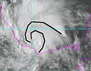
SouthDadeFish wrote:Looks rather impressive to me:
[img ]http://img96.imageshack.us/img96/821/6tvp.jpg[/img]
Convection is wrapping quite impressively. Makes me wonder if those winds are a little higher in the mid-level then they appear.
0 likes
Re: ATL: INVEST 95L - Discussion
I must be missing something, but I can't see this not making landfall before one or 2 am tonite it has already made it halfway across the BOC and it didn't get offshore before, what 8pm last nite.
0 likes
The following post is NOT an official forecast and should not be used as such. It is just the opinion of the poster and may or may not be backed by sound meteorological data. It is NOT endorsed by any professional institution including storm2k.org For Official Information please refer to the NHC and NWS products.
-
SouthDadeFish
- Professional-Met
- Posts: 2835
- Joined: Thu Sep 23, 2010 2:54 pm
- Location: Miami, FL
- Contact:


Re: ATL: INVEST 95L - Discussion
Radar & satellite along with surface reports show that it has a closed circulation, by the time recon gets there I think it will be upgraded straight to TS Fernand.
Last edited by NDG on Sun Aug 25, 2013 11:24 am, edited 1 time in total.
0 likes
-
SouthDadeFish
- Professional-Met
- Posts: 2835
- Joined: Thu Sep 23, 2010 2:54 pm
- Location: Miami, FL
- Contact:
Who is online
Users browsing this forum: No registered users and 23 guests