EPAC: KIKO - Post-Tropical

Moderator: S2k Moderators

Message
Author
User avatar
Hurricane_Luis
Category 2
Category 2
Posts: 723
Age: 25
Joined: Sat Jun 23, 2012 3:14 pm
Location: Tiptree, Essex, United Kingdom
Contact:

Re: EPAC: KIKO - Tropical Storm

#41 Postby Hurricane_Luis » Sat Aug 31, 2013 5:57 pm

And the eye is on its way back.

Tropical Storm Kiko

Image
0 likes   

User avatar
Yellow Evan
Professional-Met
Professional-Met
Posts: 15948
Age: 25
Joined: Fri Jul 15, 2011 12:48 pm
Location: Henderson, Nevada/Honolulu, HI
Contact:

#42 Postby Yellow Evan » Sat Aug 31, 2013 6:20 pm

I'd go with 55 knts personally.
Last edited by Yellow Evan on Sat Aug 31, 2013 9:09 pm, edited 1 time in total.
0 likes   

User avatar
Yellow Evan
Professional-Met
Professional-Met
Posts: 15948
Age: 25
Joined: Fri Jul 15, 2011 12:48 pm
Location: Henderson, Nevada/Honolulu, HI
Contact:

#43 Postby Yellow Evan » Sat Aug 31, 2013 6:21 pm

Image
0 likes   

RL3AO
Moderator-Pro Met
Moderator-Pro Met
Posts: 16308
Joined: Thu Jun 14, 2007 10:03 pm
Location: NC

#44 Postby RL3AO » Sat Aug 31, 2013 6:26 pm

Image

Continues to improve on microwave. I'd estimate 55 to 60kt.
0 likes   

User avatar
Macrocane
Category 5
Category 5
Posts: 4218
Age: 35
Joined: Sun May 24, 2009 5:35 pm
Location: El Salvador

Re: EPAC: KIKO - Tropical Storm

#45 Postby Macrocane » Sat Aug 31, 2013 8:00 pm

A nice surprise for this really weird Northern Hemisphere tropical cyclone season.
0 likes   

supercane4867
Category 5
Category 5
Posts: 4966
Joined: Wed Nov 14, 2012 10:43 am

Re: EPAC: KIKO - Tropical Storm

#46 Postby supercane4867 » Sat Aug 31, 2013 8:29 pm

T3.5/55kt from TAFB

EP, 11, 201309010000, 10, DVTS, CI, , 1960N, 11600W, , 3, 55, 2, 994, 2, DVRK, , , , , , , , , , , , , , E, TAFB, AL, VI, 5, 3535 /////, , , GOES15, CSC, T
0 likes   

CrazyC83
Professional-Met
Professional-Met
Posts: 33391
Joined: Tue Mar 07, 2006 11:57 pm
Location: Deep South, for the first time!

#47 Postby CrazyC83 » Sat Aug 31, 2013 9:10 pm

Given the eye pattern, I would go up to 65 kt if Dvorak is as high as constraints allow.
0 likes   

hurricanes1234
Category 5
Category 5
Posts: 2903
Joined: Sat Jul 28, 2012 6:19 pm
Location: Trinidad and Tobago

Re: EPAC: KIKO - Tropical Storm

#48 Postby hurricanes1234 » Sat Aug 31, 2013 9:23 pm

Image

Looks like a Category 1 on infrared imagery.

OFF TOPIC: Did I post the image correctly? I can't remember exactly how to do it. :oops:

Personal Forecast Disclaimer: The posts in this forum are NOT official forecast and should not be used as such. They are just the opinion of the poster and may or may not be backed by sound meteorological data. They are NOT endorsed by any professional institution or storm2k.org. For official information, please refer to the NHC and NWS products.
0 likes   
PLEASE NOTE: With the exception of information from weather agencies that I may copy and paste here, my posts will NEVER be official, since I am NOT a meteorologist. They are solely my amateur opinion, and may or may not be accurate. Therefore, please DO NOT use them as official details, particularly when making important decisions. Thank you.

User avatar
cycloneye
Admin
Admin
Posts: 138789
Age: 67
Joined: Thu Oct 10, 2002 10:54 am
Location: San Juan, Puerto Rico

Re: EPAC: KIKO - Tropical Storm

#49 Postby cycloneye » Sat Aug 31, 2013 9:42 pm

BULLETIN
TROPICAL STORM KIKO ADVISORY NUMBER 5
NWS NATIONAL HURRICANE CENTER MIAMI FL EP112013
800 PM PDT SAT AUG 31 2013

...KIKO CLOSE TO HURRICANE STRENGTH...


SUMMARY OF 800 PM PDT...0300 UTC...INFORMATION
----------------------------------------------
LOCATION...20.0N 115.8W
ABOUT 430 MI...690 KM WSW OF THE SOUTHERN TIP OF BAJA CALIFORNIA
MAXIMUM SUSTAINED WINDS...70 MPH...110 KM/H
PRESENT MOVEMENT...N OR 10 DEGREES AT 7 MPH...11 KM/H
MINIMUM CENTRAL PRESSURE...993 MB...29.32 INCHES


TROPICAL STORM KIKO DISCUSSION NUMBER 5
NWS NATIONAL HURRICANE CENTER MIAMI FL EP112013
800 PM PDT SAT AUG 31 2013

KIKO IS CONTINUING TO INTENSIFY AT A FAST PACE. MICROWAVE IMAGES
INDICATE THAT THE STORM HAS AN INNER CORE...AND EVEN THE LAST FEW
VISIBLE IMAGES SUGGESTED A WEAK EYE FEATURE WITHIN A MORE
SYMMETRICAL CDO. THE INTENSITY IS SET TO 60 KT...A BIT HIGHER THAN
THE LATEST SATELLITE CLASSIFICATIONS...WHICH HAVE HAD A HARD TIME
KEEPING UP WITH THIS CYCLONE. THE PACE OF STRENGTHENING SHOULD
DIMINISH SOON AS KIKO IS MOVING ACROSS COOLING WATERS...AND WILL BE
CROSSING THE 26C ISOTHERM WITHIN 12-24H. AFTER THAT TIME...A MORE
STEADY DECREASE IN STRENGTH SEEMS PROBABLE DUE TO INCREASING
SOUTHWESTERLY SHEAR...COOLER WATERS...AND ENTRAINMENT OF DRY AIR
ALOFT. THE LATEST NHC PREDICTION IS CLOSE TO A BLEND OF THE
PREVIOUS FORECAST...THE INTENSITY CONSENSUS...AND THE FLORIDA STATE
SUPERENSEMBLE. THE CYCLONE IS LIKELY TO BECOME A REMNANT LOW IN
ABOUT THREE DAYS AND DISSIPATE IN ABOUT FOUR DAYS...CONSISTENT WITH
THE GLOBAL MODEL SOLUTIONS.

KIKO HAS BEEN SURPRISINGLY MOVING A BIT EAST OF NORTH DURING THE
PAST FEW HOURS...010/6. IT APPEARS TO BE ROTATING AROUND THE EAST
SIDE OF A MID/UPPER-LEVEL LOW...WHICH SHOULD CAUSE THE STORM TO
GRADUALLY TURN TO THE NORTH AND NORTH-NORTHWEST OVER THE NEXT DAY
OR SO. MODEL GUIDANCE HAS TAKEN A NOTABLE SHIFT TO THE EAST...AND
THE NHC FORECAST IS SHIFTED EASTWARD BY 30-45 NMI AT MOST TIME
PERIODS ON THIS PACKAGE. IN 36-48H...THE CYCLONE WILL LIKELY
DECOUPLE VERTICALLY...AND THEN BECOME NEARLY STATIONARY FOR A
COUPLE OF DAYS IN LIGHT LOW-LEVEL FLOW.


FORECAST POSITIONS AND MAX WINDS

INIT 01/0300Z 20.0N 115.8W 60 KT 70 MPH
12H 01/1200Z 20.8N 115.8W 65 KT 75 MPH
24H 02/0000Z 21.6N 116.0W 60 KT 70 MPH
36H 02/1200Z 22.2N 116.1W 50 KT 60 MPH
48H 03/0000Z 22.3N 116.2W 40 KT 45 MPH
72H 04/0000Z 22.2N 116.3W 30 KT 35 MPH...POST-TROP/REMNT LOW
96H 05/0000Z...DISSIPATED

$$
FORECASTER BLAKE

0 likes   
Visit the Caribbean-Central America Weather Thread where you can find at first post web cams,radars
and observations from Caribbean basin members Click Here

hurricanes1234
Category 5
Category 5
Posts: 2903
Joined: Sat Jul 28, 2012 6:19 pm
Location: Trinidad and Tobago

Re: EPAC: KIKO - Tropical Storm

#50 Postby hurricanes1234 » Sat Aug 31, 2013 9:49 pm

Kiko might peak between 80 and 90 mph in the next 6-18 hours, in my opinion. Very impressive storm right now, definitely not what anyone expected.

Personal Forecast Disclaimer: The posts in this forum are NOT official forecast and should not be used as such. They are just the opinion of the poster and may or may not be backed by sound meteorological data. They are NOT endorsed by any professional institution or storm2k.org. For official information, please refer to the NHC and NWS products.
0 likes   
PLEASE NOTE: With the exception of information from weather agencies that I may copy and paste here, my posts will NEVER be official, since I am NOT a meteorologist. They are solely my amateur opinion, and may or may not be accurate. Therefore, please DO NOT use them as official details, particularly when making important decisions. Thank you.

User avatar
Macrocane
Category 5
Category 5
Posts: 4218
Age: 35
Joined: Sun May 24, 2009 5:35 pm
Location: El Salvador

Re: EPAC: KIKO - Tropical Storm

#51 Postby Macrocane » Sat Aug 31, 2013 10:06 pm

Poor models (in every sense of poor) have had a hard time forecasting genesis and intensity of the tropical cyclones in every basin this year. This year has showed us how much we still have to learn about weather and climate.
0 likes   

User avatar
Yellow Evan
Professional-Met
Professional-Met
Posts: 15948
Age: 25
Joined: Fri Jul 15, 2011 12:48 pm
Location: Henderson, Nevada/Honolulu, HI
Contact:

Re: EPAC: KIKO - Tropical Storm

#52 Postby Yellow Evan » Sat Aug 31, 2013 10:50 pm

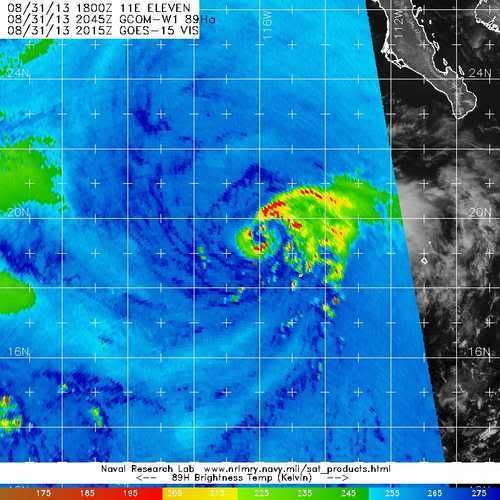
hurricanes1234 wrote:Kiko might peak between 80 and 90 mph in the next 6-18 hours, in my opinion. Very impressive storm right now, definitely not what anyone expected.

Personal Forecast Disclaimer: The posts in this forum are NOT official forecast and should not be used as such. They are just the opinion of the poster and may or may not be backed by sound meteorological data. They are NOT endorsed by any professional institution or storm2k.org. For official information, please refer to the NHC and NWS products.


At this rate, who knows. It's almost like Kirk 12. I'd say it could peak anywhere from 60-75.
0 likes   

User avatar
Yellow Evan
Professional-Met
Professional-Met
Posts: 15948
Age: 25
Joined: Fri Jul 15, 2011 12:48 pm
Location: Henderson, Nevada/Honolulu, HI
Contact:

#53 Postby Yellow Evan » Sun Sep 01, 2013 1:31 am

Kiko may not become a hurricane after all. Looks kinda dead IMO.
0 likes   

hurricanes1234
Category 5
Category 5
Posts: 2903
Joined: Sat Jul 28, 2012 6:19 pm
Location: Trinidad and Tobago

Re: EPAC: KIKO - Tropical Storm

#54 Postby hurricanes1234 » Sun Sep 01, 2013 4:34 am

So we could be this close to having a hurricane, yet still miss it because of increasingly unfavourable conditions. I also do not think it will strengthen into a hurricane, but it is still possible. If this does not become a hurricane, I would be sad to know it was 4 mph away from that status.

Personal Forecast Disclaimer: The posts in this forum are NOT official forecast and should not be used as such. They are just the opinion of the poster and may or may not be backed by sound meteorological data. They are NOT endorsed by any professional institution or storm2k.org. For official information, please refer to the NHC and NWS products.
0 likes   
PLEASE NOTE: With the exception of information from weather agencies that I may copy and paste here, my posts will NEVER be official, since I am NOT a meteorologist. They are solely my amateur opinion, and may or may not be accurate. Therefore, please DO NOT use them as official details, particularly when making important decisions. Thank you.

hurricanes1234
Category 5
Category 5
Posts: 2903
Joined: Sat Jul 28, 2012 6:19 pm
Location: Trinidad and Tobago

Re: EPAC: KIKO - Tropical Storm

#55 Postby hurricanes1234 » Sun Sep 01, 2013 9:15 am

Best Track remains just short of hurricane strength. This will probably be upgraded to a hurricane in the re-analysis. Here's an AVN picture showing significant warming of cloudtops, meaning that it could already be going downhill. May not become a hurricane (60% chance of not happening). Thoughts?

Image

Personal Forecast Disclaimer: The posts in this forum are NOT official forecast and should not be used as such. They are just the opinion of the poster and may or may not be backed by sound meteorological data. They are NOT endorsed by any professional institution or storm2k.org. For official information, please refer to the NHC and NWS products.
0 likes   
PLEASE NOTE: With the exception of information from weather agencies that I may copy and paste here, my posts will NEVER be official, since I am NOT a meteorologist. They are solely my amateur opinion, and may or may not be accurate. Therefore, please DO NOT use them as official details, particularly when making important decisions. Thank you.

User avatar
Yellow Evan
Professional-Met
Professional-Met
Posts: 15948
Age: 25
Joined: Fri Jul 15, 2011 12:48 pm
Location: Henderson, Nevada/Honolulu, HI
Contact:

#56 Postby Yellow Evan » Sun Sep 01, 2013 9:38 am

000
WTPZ41 KNHC 011434
TCDEP1

TROPICAL STORM KIKO DISCUSSION NUMBER 7
NWS NATIONAL HURRICANE CENTER MIAMI FL EP112013
800 AM PDT SUN SEP 01 2013

A TRMM MICROWAVE OVERPASS AT 1122Z INDICATED THAT KIKO POSSESSED A
WELL-DEFINED MID-LEVEL EYE...BUT THERE WAS NO CLOSED LOW-LEVEL EYE
BENEATH IT. SATELLITE INTENSITY ESTIMATES RANGE FROM A CIRA AMSU
ESTIMATE OF 42 KT TO AS HIGH AS 72 KT FROM BOTH CIMSS AMSU AND ADT
ESTIMATES. ALTHOUGH KIKO COULD HAVE BRIEFLY BEEN A HURRICANE...THE
INITIAL INTENSITY IS BEING MAINTAINED AT 60 KT...WHICH IS SLIGHTLY
HIGHER THAN THE T3.5/55 KT ESTIMATES FROM BOTH TAFB AND SAB.

THE INITIAL MOTION IS NOW 360/06 KT. KIKO IS EXPECTED TO CONTINUE
MOVING NORTHWARD TODAY AND GRADUALLY SLOW DOWN BEFORE TURNING
TOWARD THE NORTH-NORTHWEST ON MONDAY AND TUESDAY WHILE THE CYCLONE
WEAKENS AND MOVES AROUND THE EASTERN PERIPHERY OF A MID- TO
UPPER-LEVEL LOW. AS KIKO WEAKENS AND BECOMES A MORE VERTICALLY
SHALLOW SYSTEM...IT COULD GET TRAPPED AND BECOME STATIONARY IN THE
WEAK LOW-LEVEL FLOW ASSOCIATED WITH A LARGE-SCALE CYCLONIC GYRE
THAT HAS BEEN A PERSISTENT FEATURE ACROSS THE EASTERN NORTH PACIFIC
THE PAST COUPLE OF WEEKS. THE OFFICIAL FORECAST TRACK IS SIMILAR TO
THE PREVIOUS ADVISORY TRACK...AND LIES CLOSE TO THE MULTI-MODEL
CONSENSUS TVCE.

KIKO IS STILL OVER SSTS NEAR 27C...BUT IT WILL BE MOVING OVER
SUB-26C OCEAN TEMPERATURES WITHIN THE NEXT 12 HOURS OR SO...WHICH
SHOULD ACT TO INDUCE STEADY WEAKENING. ALTHOUGH THE VERTICAL SHEAR
IS LOW...THE ENTRAINMENT OF DRIER AND MORE STABLE AIR TO THE NORTH
OF THE CYCLONE SHOULD ALSO HASTEN THE WEAKENING OF KIKO. THE
CYCLONE IS EXPECTED TO BECOME A REMNANT LOW BY 72 HOURS WHEN THE
LOW- AND UPPER-LEVEL CIRCULATIONS DECOUPLE AFTER THE SYSTEM LOSES
MOST...IF NOT ALL...OF ITS CONVECTION OVER 23-24C SSTS BY THAT
TIME. THE NHC INTENSITY FORECAST FOLLOWS THE TREND OF THE PREVIOUS
ADVISORY...AS WELL AS THE SHIPS AND LGEM STATISTICAL-DYNAMICAL
INTENSITY MODELS.

FORECAST POSITIONS AND MAX WINDS

INIT 01/1500Z 21.3N 115.6W 60 KT 70 MPH
12H 02/0000Z 21.9N 115.8W 55 KT 65 MPH
24H 02/1200Z 22.6N 116.0W 45 KT 50 MPH
36H 03/0000Z 23.1N 116.1W 40 KT 45 MPH
48H 03/1200Z 23.4N 116.2W 30 KT 35 MPH
72H 04/1200Z 23.8N 116.4W 20 KT 25 MPH...POST-TROP/REMNT LOW
96H 05/1200Z...DISSIPATED

$$
FORECASTER STEWART
0 likes   

hurricanes1234
Category 5
Category 5
Posts: 2903
Joined: Sat Jul 28, 2012 6:19 pm
Location: Trinidad and Tobago

Re: EPAC: KIKO - Tropical Storm

#57 Postby hurricanes1234 » Sun Sep 01, 2013 11:25 am

Seeing that the discussion stated that Kiko could have briefly been a hurricane, when do you all think that it was most likely at that intensity?
0 likes   
PLEASE NOTE: With the exception of information from weather agencies that I may copy and paste here, my posts will NEVER be official, since I am NOT a meteorologist. They are solely my amateur opinion, and may or may not be accurate. Therefore, please DO NOT use them as official details, particularly when making important decisions. Thank you.

User avatar
Hurricane_Luis
Category 2
Category 2
Posts: 723
Age: 25
Joined: Sat Jun 23, 2012 3:14 pm
Location: Tiptree, Essex, United Kingdom
Contact:

Re: EPAC: KIKO - Tropical Storm

#58 Postby Hurricane_Luis » Sun Sep 01, 2013 2:18 pm

hurricanes1234 wrote:Seeing that the discussion stated that Kiko could have briefly been a hurricane, when do you all think that it was most likely at that intensity?


August 31st 18:45. When the eye was most distinct.

Image
0 likes   

User avatar
Hurricane_Luis
Category 2
Category 2
Posts: 723
Age: 25
Joined: Sat Jun 23, 2012 3:14 pm
Location: Tiptree, Essex, United Kingdom
Contact:

#59 Postby Hurricane_Luis » Sun Sep 01, 2013 2:21 pm

This is what Kiko looks like now.

Image
0 likes   

CrazyC83
Professional-Met
Professional-Met
Posts: 33391
Joined: Tue Mar 07, 2006 11:57 pm
Location: Deep South, for the first time!

#60 Postby CrazyC83 » Sun Sep 01, 2013 2:26 pm

I'd say peak intensity was at 0000Z, as a Cat 1 hurricane.
0 likes   


Return to “2013”

Who is online

Users browsing this forum: No registered users and 11 guests