ATL: HUMBERTO - Remnants - Discussion
Moderator: S2k Moderators
Re: ATL: HUMBERTO - Hurricane - Discussion
If that happens, you can pretty much count out any kind of ridge across the eastern and central Atlantic for the next couple of weeks. My guess is that this will be around for a long time, intensify and really pump up the ACE after 5 days. Fortunately, no land will likely be affected (outside perhaps the Azores when it finally had enough).
0 likes

-
cycloneye

- Admin

- Posts: 139044
- Age: 67
- Joined: Thu Oct 10, 2002 10:54 am
- Location: San Juan, Puerto Rico
Re: ATL: HUMBERTO - Hurricane - Discussion
00z Best Track remains at 75kts.
AL, 09, 2013091300, , BEST, 0, 231N, 294W, 75, 980, HU
AL, 09, 2013091300, , BEST, 0, 231N, 294W, 75, 980, HU
0 likes
Visit the Caribbean-Central America Weather Thread where you can find at first post web cams,radars
and observations from Caribbean basin members Click Here
and observations from Caribbean basin members Click Here
-
supercane4867
- Category 5

- Posts: 4966
- Joined: Wed Nov 14, 2012 10:43 am
Re: ATL: HUMBERTO - Hurricane - Discussion
cycloneye wrote:AL, 09, 2013091300, , BEST, 0, 231N, 294W, 75, 980, HU
Interesting pressure drop, could mean Humberto is expanding its size again
0 likes
-
hurricanes1234
- Category 5
- Posts: 2903
- Joined: Sat Jul 28, 2012 6:19 pm
- Location: Trinidad and Tobago
Re: ATL: HUMBERTO - Hurricane - Discussion
This would now mean that Humberto has a new peak intensity. Interesting and fun little (big) storm. 
The posts in this forum are NOT official forecast and should not be used as such. They are just the opinion of the poster and may or may not be backed by sound meteorological data. They are NOT endorsed by any professional institution or storm2k.org. For official information, please refer to the NHC and NWS products.
The posts in this forum are NOT official forecast and should not be used as such. They are just the opinion of the poster and may or may not be backed by sound meteorological data. They are NOT endorsed by any professional institution or storm2k.org. For official information, please refer to the NHC and NWS products.
0 likes
PLEASE NOTE: With the exception of information from weather agencies that I may copy and paste here, my posts will NEVER be official, since I am NOT a meteorologist. They are solely my amateur opinion, and may or may not be accurate. Therefore, please DO NOT use them as official details, particularly when making important decisions. Thank you.
-
tolakram
- Admin
- Posts: 19165
- Age: 60
- Joined: Sun Aug 27, 2006 8:23 pm
- Location: Florence, KY (name is Mark)
Re: ATL: HUMBERTO - Hurricane - Discussion
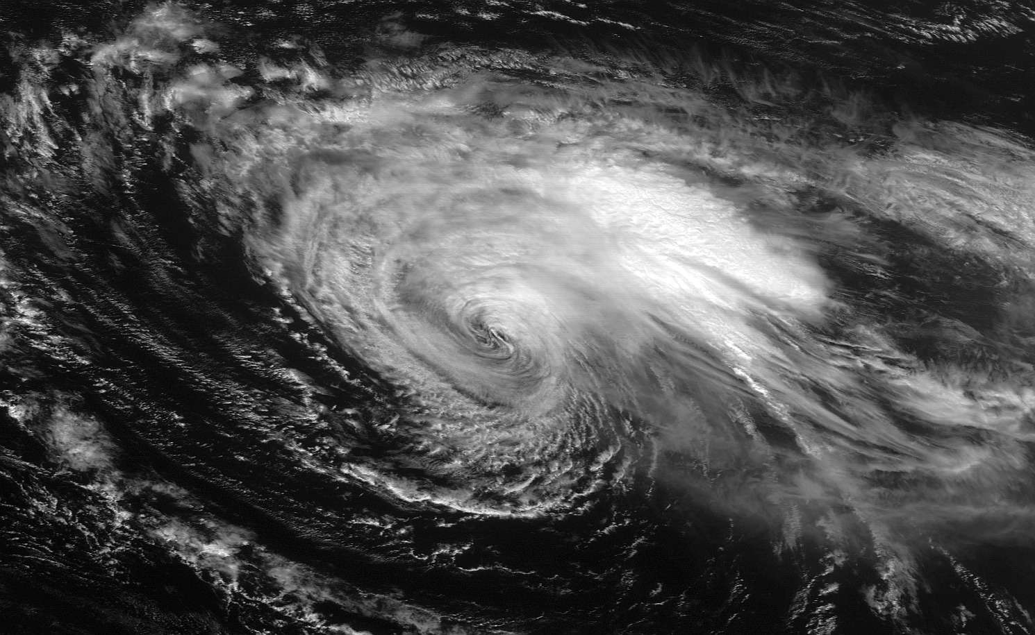
from 14:15Z
0 likes
M a r k
- - - - -
Join us in chat: Storm2K Chatroom Invite. Android and IOS apps also available.
The posts in this forum are NOT official forecasts and should not be used as such. Posts are NOT endorsed by any professional institution or STORM2K.org. For official information and forecasts, please refer to NHC and NWS products.
-
Hurricane_Luis

- Category 2

- Posts: 723
- Age: 25
- Joined: Sat Jun 23, 2012 3:14 pm
- Location: Tiptree, Essex, United Kingdom
- Contact:
Re: ATL: HUMBERTO - Tropical Storm - Discussion
000
WTNT34 KNHC 131449
TCPAT4
BULLETIN
TROPICAL STORM HUMBERTO ADVISORY NUMBER 20
NWS NATIONAL HURRICANE CENTER MIAMI FL AL092013
1100 AM AST FRI SEP 13 2013
...HUMBERTO WEAKENS TO A TROPICAL STORM...
SUMMARY OF 1100 AM AST...1500 UTC...INFORMATION
-----------------------------------------------
LOCATION...24.7N 31.3W
ABOUT 765 MI...1230 KM NW OF THE CAPE VERDE ISLANDS
MAXIMUM SUSTAINED WINDS...65 MPH...100 KM/H
PRESENT MOVEMENT...WNW OR 300 DEGREES AT 10 MPH...17 KM/H
MINIMUM CENTRAL PRESSURE...991 MB...29.26 INCHES
WATCHES AND WARNINGS
--------------------
THERE ARE NO COASTAL WATCHES OR WARNINGS IN EFFECT.
DISCUSSION AND 48-HOUR OUTLOOK
------------------------------
AT 1100 AM AST...1500 UTC...THE CENTER OF TROPICAL STORM HUMBERTO
WAS LOCATED NEAR LATITUDE 24.7 NORTH...LONGITUDE 31.3 WEST. HUMBERTO
IS MOVING TOWARD THE WEST-NORTHWEST NEAR 10 MPH...17 KM/H...AND THIS
GENERAL MOTION IS EXPECTED FOR THE NEXT COUPLE OF DAYS.
MAXIMUM SUSTAINED WINDS ARE NEAR 65 MPH...100 KM/H...WITH HIGHER
GUSTS. ADDITIONAL WEAKENING IS FORECAST DURING THE NEXT 48 HOURS.
TROPICAL STORM FORCE WINDS EXTEND OUTWARD UP TO 205 MILES...335 KM
FROM THE CENTER.
THE ESTIMATED MINIMUM CENTRAL PRESSURE IS 991 MB...29.26 INCHES.
HAZARDS AFFECTING LAND
----------------------
NONE.
NEXT ADVISORY
-------------
NEXT COMPLETE ADVISORY...500 PM AST.
$$
FORECASTER BLAKE
0 likes
-
Florida1118
- Category 5
- Posts: 1805
- Age: 27
- Joined: Sat Jun 19, 2010 12:57 pm
- Location: Tampa, Florida
Re: ATL: HUMBERTO - Tropical Storm - Discussion
Possibility than Humberto is going to be a hurricane again perhaps:
FURTHER WEAKENING SEEMS PROBABLE FOR THE NEXT
DAY OR SO DUE TO INCREASING SOUTHWESTERLY SHEAR AND MARGINAL SSTS.
IN A COUPLE OF DAYS...THE VERTICAL WIND SHEAR SHOULD BEGIN TO
DIMINISH WHILE HUMBERTO MOVES OVER WARMER WATERS...WHICH COULD
ALLOW FOR SOME RESTRENGTHENING. GLOBAL MODELS SUGGEST THAT THE
STORM WILL UNDERGO A TROUGH INTERACTION IN THE LONG RANGE...LEAVING
IT IN A FAVORABLE ENVIRONMENT TO BECOME EVEN STRONGER.
INIT 13/1500Z 24.7N 31.3W 55 KT 65 MPH
12H 14/0000Z 25.4N 32.7W 45 KT 50 MPH
24H 14/1200Z 26.3N 35.0W 40 KT 45 MPH
36H 15/0000Z 27.4N 37.3W 40 KT 45 MPH
48H 15/1200Z 28.5N 39.4W 40 KT 45 MPH
72H 16/1200Z 30.7N 42.5W 45 KT 50 MPH
96H 17/1200Z 32.8N 45.0W 55 KT 65 MPH
120H 18/1200Z 36.5N 44.5W 65 KT 75 MPH
0 likes
-
HurricaneBelle

- S2K Supporter

- Posts: 974
- Joined: Sun Aug 27, 2006 6:12 pm
- Location: Clearwater, FL
-
cycloneye
- Admin
- Posts: 139044
- Age: 67
- Joined: Thu Oct 10, 2002 10:54 am
- Location: San Juan, Puerto Rico
Re: ATL: HUMBERTO - Tropical Storm - Discussion
18z Best Track.
AL, 09, 2013091318, , BEST, 0, 248N, 316W, 50, 994, TS
AL, 09, 2013091318, , BEST, 0, 248N, 316W, 50, 994, TS
0 likes
Visit the Caribbean-Central America Weather Thread where you can find at first post web cams,radars
and observations from Caribbean basin members Click Here
and observations from Caribbean basin members Click Here

-
HurricaneBelle
- S2K Supporter
- Posts: 974
- Joined: Sun Aug 27, 2006 6:12 pm
- Location: Clearwater, FL
Re: Re:
Spin wrote:HurricaneBelle wrote:At the moment, Humberto is a half-icane, the entire eastern half consists of convection-less low clouds.
Did you mean the west half?
er, yeah. He's so far east the west side seems like the east.
0 likes
-
supercane4867
- Category 5
- Posts: 4966
- Joined: Wed Nov 14, 2012 10:43 am
Re: ATL: HUMBERTO - Tropical Storm - Discussion
There've been storms in the past that went through 60kt of shear and restrengthened

0 likes
-
TheStormExpert

- Category 5
- Posts: 8487
- Age: 30
- Joined: Wed Feb 16, 2011 5:38 pm
- Location: Palm Beach Gardens, FL
Dang! Looking at the Atlantic Wide View AVN Satellite below Humberto has really taken a major beating over the past 24hrs. Though were it's presently located in the East-Central Atlantic does not make it surprising at all.

0 likes
The following post is NOT an official forecast and should not be used as such. It is just the opinion of the poster and may or may not be backed by sound meteorological data. It is NOT endorsed by storm2k.org.
Re: ATL: HUMBERTO - Tropical Storm - Discussion
He's down but he may not be down for long...

0 likes
-
SeGaBob
For the 11pm advisory NHC needs to drop this to a TD as it's losing a lot of organization right now...
The posts in this forum are NOT official forecast and should not be used as such. They are just the opinion of the poster and may or may not be backed by sound meteorological data. They are NOT endorsed by any professional institution or storm2k.org. For official information, please refer to the NHC and NWS products.
The posts in this forum are NOT official forecast and should not be used as such. They are just the opinion of the poster and may or may not be backed by sound meteorological data. They are NOT endorsed by any professional institution or storm2k.org. For official information, please refer to the NHC and NWS products.
0 likes
-
supercane4867
- Category 5
- Posts: 4966
- Joined: Wed Nov 14, 2012 10:43 am
Re: ATL: HUMBERTO - Tropical Storm - Discussion
Still calling for a hurricane by day 5
FORECAST POSITIONS AND MAX WINDS
INIT 14/0300Z 24.8N 33.0W 40 KT 45 MPH
12H 14/1200Z 25.4N 34.8W 35 KT 40 MPH...POST-TROPICAL
24H 15/0000Z 26.3N 37.2W 30 KT 35 MPH...POST-TROP/REMNT LOW
36H 15/1200Z 27.2N 39.3W 30 KT 35 MPH...POST-TROP/REMNT LOW
48H 16/0000Z 28.2N 41.1W 30 KT 35 MPH...POST-TROP/REMNT LOW
72H 17/0000Z 30.3N 43.7W 35 KT 40 MPH
96H 18/0000Z 32.6N 45.1W 50 KT 60 MPH
120H 19/0000Z 36.5N 43.5W 65 KT 75 MPH
0 likes
Who is online
Users browsing this forum: No registered users and 40 guests