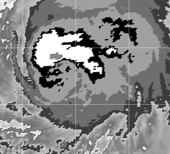
ATL: HUMBERTO - Remnants - Discussion

Moderator: S2k Moderators

Message
Author
Alyono
Professional-Met
Professional-Met
Posts: 6961
Joined: Fri Apr 26, 2013 3:52 pm
Location: Texas Coast

Re: Re:

#541 Postby Alyono » Wed Sep 11, 2013 9:06 pm

ozonepete wrote:
Alyono wrote:looks like a 4.5 at most


?? Even conservative CIMSS ADT has it at 4.6.


that is very near a 4.5
0 likes   

ozonepete
Professional-Met
Professional-Met
Posts: 4743
Joined: Mon Sep 07, 2009 3:23 pm
Location: From Ozone Park, NYC / Now in Brooklyn, NY

Re: Re:

#542 Postby ozonepete » Wed Sep 11, 2013 9:09 pm

Alyono wrote:
ozonepete wrote:
Alyono wrote:looks like a 4.5 at most


?? Even conservative CIMSS ADT has it at 4.6.


that is very near a 4.5


Lol, yeah. I was saying that when CIMSS says 4.6 on a TC like this I think 5.0. :wink:
0 likes   

ozonepete
Professional-Met
Professional-Met
Posts: 4743
Joined: Mon Sep 07, 2009 3:23 pm
Location: From Ozone Park, NYC / Now in Brooklyn, NY

Re: ATL: HUMBERTO - Hurricane - Discussion

#543 Postby ozonepete » Wed Sep 11, 2013 9:20 pm

Pretty sure it's been moving NNE (maybe 15 degrees or so) the last few hours.
0 likes   

supercane4867
Category 5
Category 5
Posts: 4966
Joined: Wed Nov 14, 2012 10:43 am

Re: ATL: HUMBERTO - Hurricane - Discussion

#544 Postby supercane4867 » Wed Sep 11, 2013 9:49 pm

11pm advisory still at 75kt but pressure down to 982mb
0 likes   

User avatar
Macrocane
Category 5
Category 5
Posts: 4218
Age: 35
Joined: Sun May 24, 2009 5:35 pm
Location: El Salvador

Re: ATL: HUMBERTO - Hurricane - Discussion

#545 Postby Macrocane » Wed Sep 11, 2013 11:30 pm

It looks to me like Humberto has intensified a bit tonight with colder cloud tops, a "thicker" CDO and the eye trying to show on IR.
0 likes   

User avatar
fci
S2K Supporter
S2K Supporter
Posts: 3296
Joined: Tue Sep 14, 2004 10:29 am
Location: Lake Worth, FL

Re: Re:

#546 Postby fci » Thu Sep 12, 2013 1:59 am

TheStormExpert wrote:
northjaxpro wrote:Well, Mother Nature made us wait seemingly forever, but she has finally given us a full fledged hurricane to track in the Atlantic basin.

Humberto has become a large and rather formidable tropical cyclone. It looks as if will be around for quite some time to come. I will be interested to see what happens in about 5 days after the storm finishes traverses over cooler SSTs and moves into the Central Atlantic.

Maybe mother nature saved the best for last this season.


Oh, this is far from last.
The season is just starting and the next 6 weeks or so could be a roller-coaster ride.
I have no scientific data to support me but Mother Nature doesn't take a season off and thus far we have had a fluky quiet season.
There is a lot of heat out there and she has to expend a lot of energy before she shuts down the season.
This is not the last one.....
0 likes   
Personal Forecast Disclaimer:
My posts are just my opinion and are most likely not backed by sound meteorological data. They are NOT endorsed by any professional institution or storm2k.org. For official information, please refer to the NHC and NWS products.
Bottom line is that I am just expressing my opinion!!!

RL3AO
Moderator-Pro Met
Moderator-Pro Met
Posts: 16308
Joined: Thu Jun 14, 2007 10:03 pm
Location: NC

#547 Postby RL3AO » Thu Sep 12, 2013 2:34 am

Still looks like a 4.5, which is what SSD went with. Once you get into the eye pattern, it becomes much less subjective.
0 likes   

User avatar
Blown Away
S2K Supporter
S2K Supporter
Posts: 9861
Joined: Wed May 26, 2004 6:17 am

Re: ATL: HUMBERTO - Hurricane - Discussion

#548 Postby Blown Away » Thu Sep 12, 2013 7:16 am

Image
Very rare to have a cane in this area...Strange year so far...
0 likes   
Hurricane Eye Experience: David 79, Irene 99, Frances 04, Jeanne 04, Wilma 05...
Hurricane Brush Experience: Andrew 92, Erin 95, Floyd 99, Matthew 16, Irma 17, Ian 22, Nicole 22…

RL3AO
Moderator-Pro Met
Moderator-Pro Met
Posts: 16308
Joined: Thu Jun 14, 2007 10:03 pm
Location: NC

#549 Postby RL3AO » Thu Sep 12, 2013 7:33 am

Image

Light gray surrounds eye = 5.0

Eye adjustment: Dark gray eye surrounded by light gray = 0. However, subtract 0.5 for poorly defined eye.

Final DT = 4.5
0 likes   

RL3AO
Moderator-Pro Met
Moderator-Pro Met
Posts: 16308
Joined: Thu Jun 14, 2007 10:03 pm
Location: NC

#550 Postby RL3AO » Thu Sep 12, 2013 7:37 am

TXNT22 KNES 121217
TCSNTL

A. 09L (HUMBERTO)

B. 12/1145Z

C. 21.2N

D. 28.6W

E. ONE/GOES-E

F. T4.5/4.5/S0.0/24HRS

G. IR/EIR/VIS

H. REMARKS...DG EYE EMBEDDED IN AND SURROUNDED BY LG FOR DT=4.5.
MET AND PT AGREE. FT IS BASED ON DT.

I. ADDL POSITIONS

NIL


...SALEMI

----------

Guys from SSD see the same thing so I'm not going crazy. :lol:

I think Humberto has just about peaked. South side is starting to look worse with each frame.
0 likes   

User avatar
cycloneye
Admin
Admin
Posts: 139027
Age: 67
Joined: Thu Oct 10, 2002 10:54 am
Location: San Juan, Puerto Rico

Re: ATL: HUMBERTO - Hurricane - Discussion

#551 Postby cycloneye » Thu Sep 12, 2013 7:38 am

Remains at 75kts.

AL, 09, 2013091212, , BEST, 0, 214N, 290W, 75, 982, HU, 64, NEQ, 30, 30, 0, 0, 1011, 400, 20, 0, 0, L, 0, , 0, 0, HUMBERTO, D
0 likes   
Visit the Caribbean-Central America Weather Thread where you can find at first post web cams,radars
and observations from Caribbean basin members Click Here

CrazyC83
Professional-Met
Professional-Met
Posts: 33393
Joined: Tue Mar 07, 2006 11:57 pm
Location: Deep South, for the first time!

#552 Postby CrazyC83 » Thu Sep 12, 2013 8:19 am

Probably peaked at 0000Z. Starting to weaken it appears.
0 likes   

User avatar
cycloneye
Admin
Admin
Posts: 139027
Age: 67
Joined: Thu Oct 10, 2002 10:54 am
Location: San Juan, Puerto Rico

Re: ATL: HUMBERTO - Hurricane - Discussion

#553 Postby cycloneye » Thu Sep 12, 2013 9:42 am

...HUMBERTO MOVING A LITTLE FASTER TOWARD THE NORTH...


SUMMARY OF 1100 AM AST...1500 UTC...INFORMATION
-----------------------------------------------
LOCATION...21.8N 29.0W
ABOUT 515 MI...830 KM NW OF THE CAPE VERDE ISLANDS
MAXIMUM SUSTAINED WINDS...85 MPH...140 KM/H
PRESENT MOVEMENT...N OR 360 DEGREES AT 15 MPH...24 KM/H
MINIMUM CENTRAL PRESSURE...982 MB...29.00 INCHES

Read 11 AM Discussion here.
0 likes   
Visit the Caribbean-Central America Weather Thread where you can find at first post web cams,radars
and observations from Caribbean basin members Click Here

CrazyC83
Professional-Met
Professional-Met
Posts: 33393
Joined: Tue Mar 07, 2006 11:57 pm
Location: Deep South, for the first time!

#554 Postby CrazyC83 » Thu Sep 12, 2013 11:50 am

A wall of shear awaits...rapid weakening probably will be taking place in the next 12-24 hours unless it can somehow insulate itself.
0 likes   

User avatar
cycloneye
Admin
Admin
Posts: 139027
Age: 67
Joined: Thu Oct 10, 2002 10:54 am
Location: San Juan, Puerto Rico

Re: ATL: HUMBERTO - Hurricane - Discussion

#555 Postby cycloneye » Thu Sep 12, 2013 1:38 pm

Remains at 75kts on 18z Best Track.

AL, 09, 2013091218, , BEST, 0, 225N, 291W, 75, 982, HU
0 likes   
Visit the Caribbean-Central America Weather Thread where you can find at first post web cams,radars
and observations from Caribbean basin members Click Here

hurricaneCW
Category 5
Category 5
Posts: 1773
Joined: Wed Mar 03, 2010 6:20 am
Location: Toms River, NJ

Re: ATL: HUMBERTO - Hurricane - Discussion

#556 Postby hurricaneCW » Thu Sep 12, 2013 2:32 pm

Humberto's current look reminds me of a typical storm/minimal hurricane that goes up the east coast of the U.S, almost like an Irene type.
0 likes   

User avatar
cycloneye
Admin
Admin
Posts: 139027
Age: 67
Joined: Thu Oct 10, 2002 10:54 am
Location: San Juan, Puerto Rico

Re: ATL: HUMBERTO - Hurricane - Discussion

#557 Postby cycloneye » Thu Sep 12, 2013 3:43 pm

Interesting intensity forecast at 5 PM going up on days 4-5.

INIT 12/2100Z 23.1N 29.2W 75 KT 85 MPH
12H 13/0600Z 24.1N 30.3W 70 KT 80 MPH
24H 13/1800Z 25.2N 32.0W 65 KT 75 MPH
36H 14/0600Z 26.0N 34.2W 55 KT 65 MPH
48H 14/1800Z 26.8N 36.5W 45 KT 50 MPH
72H 15/1800Z 28.8N 40.8W 45 KT 50 MPH
96H 16/1800Z 30.5N 43.5W 45 KT 50 MPH
120H 17/1800Z 33.0N 45.0W 50 KT 60 MPH

$$
FORECASTER PASCH
0 likes   
Visit the Caribbean-Central America Weather Thread where you can find at first post web cams,radars
and observations from Caribbean basin members Click Here

User avatar
Hammy
Category 5
Category 5
Posts: 5594
Age: 40
Joined: Fri May 25, 2012 5:25 pm
Contact:

Re: ATL: HUMBERTO - Hurricane - Discussion

#558 Postby Hammy » Thu Sep 12, 2013 3:50 pm

cycloneye wrote:Interesting intensity forecast at 5 PM going up on days 4-5.

INIT 12/2100Z 23.1N 29.2W 75 KT 85 MPH
12H 13/0600Z 24.1N 30.3W 70 KT 80 MPH
24H 13/1800Z 25.2N 32.0W 65 KT 75 MPH
36H 14/0600Z 26.0N 34.2W 55 KT 65 MPH
48H 14/1800Z 26.8N 36.5W 45 KT 50 MPH
72H 15/1800Z 28.8N 40.8W 45 KT 50 MPH
96H 16/1800Z 30.5N 43.5W 45 KT 50 MPH
120H 17/1800Z 33.0N 45.0W 50 KT 60 MPH

$$
FORECASTER PASCH


Fairly surprising, they aren't forecasting the level of weakening they were before. Could the large size and moisture envelope be insulating it somewhat from the drier air as it passes through in a few days?
0 likes   
The above post is not official and should not be used as such. It is the opinion of the poster and may or may not be backed by sound meteorological data. It is not endorsed by any professional institution or storm2k.org. For official information, please refer to the NHC and NWS products.

MaineWeatherNut
Tropical Storm
Tropical Storm
Posts: 225
Joined: Sun Sep 01, 2013 5:06 pm

Re: ATL: HUMBERTO - Hurricane - Discussion

#559 Postby MaineWeatherNut » Thu Sep 12, 2013 3:54 pm

From the 5pm Discussion:

LATER ON...THE TROPICAL CYCLONE IS LIKELY TO TRAVERSE
WARMER WATERS WEST OF 40W LONGITUDE AND THE SHEAR IS FORECAST TO
RELAX A LITTLE. THUS...THE OFFICIAL WIND SPEED FORECAST HINTS AT
SOME RE-STRENGTHENING BY LATE IN PERIOD. THIS IS IN GOOD AGREEMENT
WITH THE LATEST LGEM GUIDANCE. IT SHOULD BE NOTED THAT THE GLOBAL
MODELS SUGGEST THAT HUMBERTO COULD BE EVEN STRONGER THAN INDICATED
HERE AT DAYS 4-5.
0 likes   
The content of this post does NOT constitute official forecast and should not be used as such. They are the opinion of the poster and may or may not be backed by sound meteorological data. They are NOT endorsed by any professional institution or Storm2K. For official information, please refer to the local meteorological centers of respective areas.

hurricanes1234
Category 5
Category 5
Posts: 2903
Joined: Sat Jul 28, 2012 6:19 pm
Location: Trinidad and Tobago

Re: ATL: HUMBERTO - Hurricane - Discussion

#560 Postby hurricanes1234 » Thu Sep 12, 2013 5:55 pm

I have a strange feeling that if Humberto re-strengthens, it would be even stronger than its primary peak intensity of 85mph/982 mbar. I wouldn't rule out a Category 2 hurricane. The most aggressive model here is showing a peak of 115 mph, a minimal major hurricane. This storm could end up being our #1 contestant for ranking up the below-average ACE. Should be interesting.

The posts in this forum are NOT official forecast and should not be used as such. They are just the opinion of the poster and may or may not be backed by sound meteorological data. They are NOT endorsed by any professional institution or storm2k.org. For official information, please refer to the NHC and NWS products.
0 likes   
PLEASE NOTE: With the exception of information from weather agencies that I may copy and paste here, my posts will NEVER be official, since I am NOT a meteorologist. They are solely my amateur opinion, and may or may not be accurate. Therefore, please DO NOT use them as official details, particularly when making important decisions. Thank you.


Return to “2013”

Who is online

Users browsing this forum: No registered users and 77 guests