
ATL: INGRID - Models
Moderator: S2k Moderators
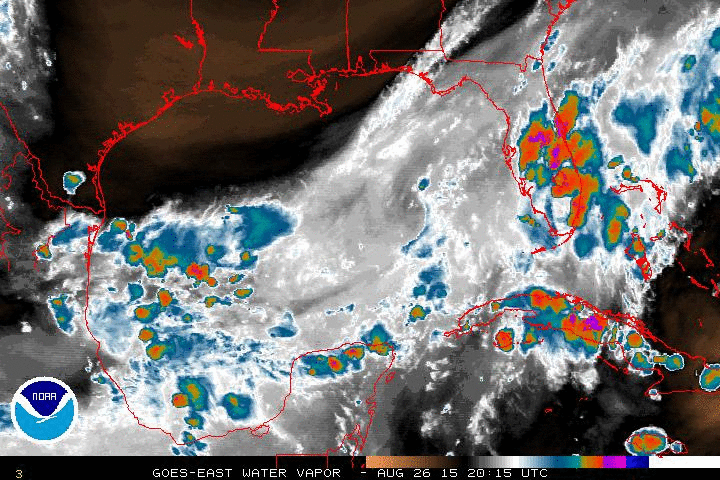
Re: ATL: INGRID - Models
12z models below show intensity peaking just below hurricane strength up to a mid-level Cat 1...intensity forecasting has been a challegne with this storm more than anything so far however...but let's watch the trend of these on later runs today
0 likes
-
Portastorm

- Storm2k Moderator

- Posts: 9787
- Age: 61
- Joined: Fri Jul 11, 2003 9:16 am
- Location: South Austin, TX
- Contact:
Re: ATL: INGRID - Models
Looks to me like more spread in the model tracks per these 12z runs, not to mention a little further north on the Mexican coastline compared to 6z.

Uploaded with ImageShack.us

Uploaded with ImageShack.us

Uploaded with ImageShack.us

Uploaded with ImageShack.us
0 likes
Any forecasts under my name are to be taken with a grain of salt. Get your best forecasts from the National Weather Service and National Hurricane Center.
I'm a certified Advanced SKYWARN-trained spotter and am active on Twitter at @TravisCOSW, a social media partner of the NWS Austin-San Antonio office.
I'm a certified Advanced SKYWARN-trained spotter and am active on Twitter at @TravisCOSW, a social media partner of the NWS Austin-San Antonio office.

Re: ATL: INGRID - Models
the 0Z EURO has this making a hard left once she feels the ridge only to loop downward into MX.....the 6Z GFS never gets her out of the BOC after her first landfall..
0 likes
-
SouthDadeFish

- Professional-Met

- Posts: 2835
- Joined: Thu Sep 23, 2010 2:54 pm
- Location: Miami, FL
- Contact:
Re:
Alyono wrote:GFS somewhat stronger at 12Z... now takes the pressure down to 980mb. Must be showing less shear
Yes, it shows a favorable upper-level environment with an anticyclone setting up overhead.
0 likes

Re: ATL: INGRID - Models
Portastorm wrote:Looks to me like more spread in the model tracks per these 12z runs, not to mention a little further north on the Mexican coastline compared to 6z.
http://img839.imageshack.us/img839/5936/ujbh.png
Uploaded with ImageShack.us
http://img812.imageshack.us/img812/4116/mf2a.png
Uploaded with ImageShack.us
There is one forecast path that has Ingrid making landfall on Texas.
Interesting to see that that some of the model have the remnant of Ingrid over Texas. Remnants of tropical storms or hurricanes can dump heavy rain over Texas like in 1921, Amelia (1978), Claudette (1979), and Allison (2001)
0 likes
-
crownweather

- S2K Supporter

- Posts: 576
- Age: 49
- Joined: Sat Aug 12, 2006 9:21 am
- Location: Sturbridge, Massachusetts
- Contact:
Re: ATL: INGRID - Models
From HPC, their Model Diagnostic Discussion with their model preference for Ingrid:
...TROPICAL STORM INGRID...
PRELIMINARY PREFERENCE: BLEND OF THE 00Z ECMWF/ECMWF ENSEMBLE MEAN
THROUGH 16/0000Z...FOLLOWED BY THE 00Z ECMWF ENSEMBLE MEAN
FORECAST CONFIDENCE: AVERAGE
THE CURRENT NATIONAL HURRICANE CENTER FORECAST INDICATES TROPICAL
STORM INGRID SHOULD ATTAIN A HURRICANE STATUS BY LATER THIS
AFTERNOON/EVENING. LANDFALLS CONTINUES TO BE FURTHER DELAYED AS
GUIDANCE HAS BEEN TRENDING IN THE SLOWER DIRECTION. CONSIDERING
HURRICANE-RESOLVING/ATCF GUIDANCE...THERE IS SOME SPREAD WITH
WHERE LANDFALL OCCURS ALTHOUGH THE LARGER MAJORITY OF THESE MODELS
LIKE A MORE SOUTHERN TRACK WHICH IS WHERE THE NHC TRACK FOLLOWS.
IN TERMS OF THE COARSER RESOLUTION MODELS...MOST OF THESE PIECES
OF GUIDANCE ARE FASTER BY 24 HOURS WHICH INCLUDES THE 12Z
NAM...00Z CMC/UKMET...AND 09Z SREF MEAN. THROUGH 36
HOURS...16/0000Z...A BLEND OF THE 00Z ECMWF/ECMWF ENSEMBLE MEAN
OFFERS SOMETHING CLOSER TO THEIR TRACK. BEYOND THAT PERIOD...THE
00Z ECWMF BECOMES SLOWER WHICH ENDS UP BEING JOINED BY THE SLOWEST
12Z GFS. THUS...WILL RECOMMEND THE 00Z ECMWF ENSEMBLE MEAN BEYOND
16/0000Z.
0 likes
Rob Lightbown
Crown Weather Services
https://crownweather.com
Crown Weather Services
https://crownweather.com
Re: ATL: INGRID - Models
hmmm...looking at the ensembles means for last nights EURO.....interesting....
http://www.ecmwf.int/products/forecasts ... 00!!!step/
http://www.ecmwf.int/products/forecasts ... 00!!!step/
0 likes
Re: ATL: INGRID - Models
12Z EURO has landfall in 48hrs...way faster than the GFS and south....waiting to see what it does after 48hrs...thats is what I am interested in.
72hrs it is gone from the surface map but I can see this looping back down...1008 pressure in the BOC...
72hrs it is gone from the surface map but I can see this looping back down...1008 pressure in the BOC...
0 likes
-
crownweather
- S2K Supporter
- Posts: 576
- Age: 49
- Joined: Sat Aug 12, 2006 9:21 am
- Location: Sturbridge, Massachusetts
- Contact:
NAVGEM also landfalls in about 48 hours and loops southward into BOC before coming back north and regenerating into a TS. Makes a 2nd landfall late next week on the Louisiana coast. Gotta love it. 
0 likes
Rob Lightbown
Crown Weather Services
https://crownweather.com
Crown Weather Services
https://crownweather.com
Re:
crownweather wrote:NAVGEM also landfalls in about 48 hours and loops southward into BOC before coming back north and regenerating into a TS. Makes a 2nd landfall late next week on the Louisiana coast. Gotta love it.
yep and now the EURO looping back down up towards Texas then hangs a right turn into FL......now that is interesting!!!!
0 likes
Re: ATL: INGRID - Models
I have this errie feeling INGRID is not done once she heads to MX if she even makes it.....if she doesnt make it then more time over water and the ridge craters...guidance keeps trending that way...
0 likes
Re: ATL: INGRID - Models
ROCK wrote:whats interesting on the 12Z CMC......the frontal system absorbs Ingrid and brings her remains right over upper TX coast...lol.....then the CMC spins up another TS in the BOC...
wash...rinse...repeat....
http://www.tropicaltidbits.com/analysis ... _watl.html
did you see NAVGEM? The same idea with throwing a system north towards TX/LA
0 likes
The posts in this forum are NOT official forecast and should not be used as such. They are just the opinion of the poster and may or may not be backed by sound meteorological data. They are NOT endorsed by any professional institution or storm2k.org. For official information, please refer to the NHC and NWS products.
Re: ATL: INGRID - Models
HurriGuy wrote:ROCK wrote:whats interesting on the 12Z CMC......the frontal system absorbs Ingrid and brings her remains right over upper TX coast...lol.....then the CMC spins up another TS in the BOC...
wash...rinse...repeat....
http://www.tropicaltidbits.com/analysis ... _watl.html
did you see NAVGEM? The same idea with throwing a system north towards TX/LA
pffft...did I see the NAVGEM?....me and the NAVGEM are like brothers now...
0 likes
-
tropicwatch

- Category 5

- Posts: 3205
- Age: 60
- Joined: Sat Jun 02, 2007 10:01 am
- Location: Panama City Florida
- Contact:
Well the front is really dipping down into the northern GOM already, cutting off any high at the moment. It might take longer for the high to build in than it is expected to do.
0 likes
Tropicwatch
Agnes 72', Eloise 75, Elena 85', Kate 85', Charley 86', Florence 88', Beryl 94', Dean 95', Erin 95', Opal 95', Earl 98', Georges 98', Ivan 2004', Arlene 2005', Dennis 2005', Ida 2009' Debby 2012' Irma 2017' Michael 2018'
Agnes 72', Eloise 75, Elena 85', Kate 85', Charley 86', Florence 88', Beryl 94', Dean 95', Erin 95', Opal 95', Earl 98', Georges 98', Ivan 2004', Arlene 2005', Dennis 2005', Ida 2009' Debby 2012' Irma 2017' Michael 2018'
-
Aric Dunn
- Category 5
- Posts: 21228
- Age: 41
- Joined: Sun Sep 19, 2004 9:58 pm
- Location: Ready for the Chase.
- Contact:
Re: ATL: INGRID - Models
ROCK wrote::uarrow: almost deep enough to pick her up...almost..
Already on the backside of the trough .. the ridge to the north should build in after that how strong and how fast it moves out will be key.
0 likes
Note: If I make a post that is brief. Please refer back to previous posts for the analysis or reasoning. I do not re-write/qoute what my initial post said each time.
If there is nothing before... then just ask
Space & Atmospheric Physicist, Embry-Riddle Aeronautical University,
I believe the sky is falling...
If there is nothing before... then just ask
Space & Atmospheric Physicist, Embry-Riddle Aeronautical University,
I believe the sky is falling...
-
Nikki

- S2K Supporter
- Posts: 291
- Joined: Mon Jun 21, 2010 3:38 pm
- Location: Santa Fe, TX (yes I typed that right TEXAS not New Mexico, I am about 20 miles from Galveston, TX)
Re: ATL: INGRID - Models
Aric Dunn wrote:ROCK wrote::uarrow: almost deep enough to pick her up...almost..
Already on the backside of the trough .. the ridge to the north should build in after that how strong and how fast it moves out will be key.
So this will affect if she hits further North or South in Mexico, correct?
0 likes
My name is Nicole and this is what I go by in Storm2k chat! Come chat with us! We have fun in there too!!
A teacher's purpose is not to create students in her own image, but to develop students who can create their own image. ~Author Unknown
Alicia, Allison, Rita, Ike
A teacher's purpose is not to create students in her own image, but to develop students who can create their own image. ~Author Unknown
Alicia, Allison, Rita, Ike

Re:
crownweather wrote:NAVGEM also landfalls in about 48 hours and loops southward into BOC before coming back north and regenerating into a TS. Makes a 2nd landfall late next week on the Louisiana coast. Gotta love it.
How crazy is that?! That NAVGEM is something else.
0 likes
Audrey (1957), Carla (1961), Hilda (1964), Betsy (1965), Edith (1971), Carmen (1974), Danny (1985), Juan (1985), Andrew (1992), Lili (2002), Rita (2005), Gustav (2008), Ike (2008), and stuck in the eye of Iniki (1992) while vacationing in Kauai.
Not an official forecast by any means.
Not an official forecast by any means.
Who is online
Users browsing this forum: No registered users and 27 guests