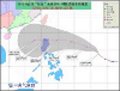
Typhoon Usagi has Made Landfall Over Batanes Islands this Morning ...
http://www.typhoon2000.ph/update.html
SUPER TYPHOON USAGI (ODETTE) UPDATE NUMBER 014
Issued at: 7:15 AM PhT (23:15 GMT) Saturday 21 September 2013
Super Typhoon USAGI (ODETTE) is now passing over the Batanes Group of Islands...bringing typhoon-force winds with heavy to extreme rainfall across the area. Its very wide wind circulation and its rainbands continues to affect Northern Luzon and Taiwan.
WPAC: USAGI - Typhoon
Moderator: S2k Moderators
-
Filipinas50
- Tropical Depression

- Posts: 77
- Age: 59
- Joined: Tue May 28, 2013 2:07 am
- Location: Planet Earth
-
supercane4867
- Category 5

- Posts: 4966
- Joined: Wed Nov 14, 2012 10:43 am
Re: WPAC: USAGI - Typhoon
Basco airport on Batan Island this morning reported a SLP of 923mb with sustained wind at 111.8 mph
0 likes
TYPHOON 17W 0:00UTC 21September2013
UW-CIMSS Experimental Vertical Shear and TC Intensity Trend Estimates
Current Conditions (from JTWC) :
Latitude : 20:46:45 N
Longitude : 121:47:10 E
Intensity (MSLP) : 910.3 hPa
Max Pot Int (MPI,from Emanuel) : 867.2 hPa
MPI differential (MSLP-MPI) : 43.1 hPa
CIMSS Vertical Shear Magnitude : 2.5 m/s
Direction : 128.5 deg
Outlook for TC Intensification Based on Current
Env. Shear Values and MPI Differential
Forecast Interval : 6hr 12hr 18hr 24hr
F F F F
Legend : VF-Very Favorable F-Favorable N-Neutral
U-Unfavorable VU-Very Unfavorable
-- Mean Intensity Trend (negative indicates TC deepening) --
6hr 12hr 18hr 24hr
VF <-3.0mb/ 6hr <-6.0mb/12hr <-9.0mb/18hr <-12.0mb/24hr
F -3.0 - -1.5 -6.0 - -3.0 -9.0 - -4.5 -12.0 - -6.0
N -1.5 - +1.5 -3.0 - +3.0 -4.5 - +4.5 -6.0 - +6.0
U +1.5 - +3.0 +3.0 - +6.0 +4.5 - +9.0 +6.0 -+12.0
VU >+3.0 >+6.0 >+9.0 >+12.0
0 likes
-
cycloneye

- Admin

- Posts: 139092
- Age: 67
- Joined: Thu Oct 10, 2002 10:54 am
- Location: San Juan, Puerto Rico
Re: WPAC: USAGI - Typhoon
00z Best Track down to 120kts.
17W USAGI 130921 0000 20.6N 121.9E WPAC 120 933
17W USAGI 130921 0000 20.6N 121.9E WPAC 120 933
0 likes
Visit the Caribbean-Central America Weather Thread where you can find at first post web cams,radars
and observations from Caribbean basin members Click Here
and observations from Caribbean basin members Click Here
-
brunota2003

- S2K Supporter

- Posts: 9476
- Age: 33
- Joined: Sat Jul 30, 2005 9:56 pm
- Location: Stanton, KY...formerly Havelock, NC
- Contact:
Re: WPAC: USAGI - Typhoon
supercane4867 wrote:Basco airport on Batan Island this morning reported a SLP of 923mb with sustained wind at 111.8 mph
It is rare that you get measured sustained winds of Cat 3 intensity or greater! That 112 mph reading is incredible!
0 likes
Just a small town southern boy helping other humans.
-
cycloneye
- Admin
- Posts: 139092
- Age: 67
- Joined: Thu Oct 10, 2002 10:54 am
- Location: San Juan, Puerto Rico
Re: WPAC: USAGI - Typhoon
WDPN32 PGTW 210300
MSGID/GENADMIN/JOINT TYPHOON WRNCEN PEARL HARBOR HI//
SUBJ/PROGNOSTIC REASONING FOR TYPHOON 17W (USAGI) WARNING NR 18//
RMKS//
1. FOR METEOROLOGISTS.
2. 6 HOUR SUMMARY AND ANALYSIS.
TYPHOON 17W (USAGI), LOCATED APPROXIMATELY 271 NM SOUTH OF
TAIPEI, TAIWAN, HAS TRACKED WEST-NORTHWESTWARD AT 08 KNOTS OVER
THE PAST SIX HOURS. ANIMATED ENHANCED INFRARED SATELLITE IMAGERY
REVEALS A SLIGHT WEAKENING TREND AS TY 17W CONTINUES TO GO THROUGH
AN EYEWALL REPLACEMENT CYCLE (ERC) AND HAS VENTURED INTO THE THE
LUZON STRAIGHT. ADDITIONALLY, THE LAND INTERACTION BETWEEN TAIWAN
AND LUZON IS BEGINNING TO DISRUPT THE LOW-LEVEL INFLOW. A 202114Z
SSMIS MICROWAVE IMAGE SHOWS THE CONTINUING ERC AND SLIGHT WEAKENING
EVEN THOUGH TY 17W HAS MAINTAINED A 15 NM EYE, CONVECTION HAS BECOME
MORE SHALLOW AND CENTRAL CONVECTION AROUND THE EYE HAS SIGNIFICANTLY
DECREASED. THE INITIAL POSITION IS BASED UPON THE EYE SEEN IN THE
AFOREMENTIONED SATELLITE IMAGERY WITH HIGH CONFIDENCE. THE INITIAL
INTENSITY HAS BEEN LOWERED TO 120 KNOTS DUE TO THE WEAKENING TREND
AND DVORAK CURRENT INTENSITY ESTIMATES THAT RANGE FROM 115 TO 140
KNOTS. UPPER-LEVEL ANALYSIS INDICATES TY 17W REMAINS IN A FAVORABLE
ENVIRONMENT WITH RADIAL OUTFLOW AND LOW (05-10 KNOT) VERTICAL WIND
SHEAR FROM A POINT SOURCE ANTICYCLONE THAT HAS REMAINED OVER THE
SYSTEM. TY 17W CONTINUES TRACKING GENERALLY WEST ALONG THE SOUTHERN
PERIPHERY OF THE SUBTROPICAL RIDGE (STR) THAT EXTENDS FROM CENTRAL
CHINA INTO THE EAST CHINA SEA.
3. FORECAST REASONING.
A. NO CHANGES TO THE FORECAST PHILOSOPHY SINCE THE PREVIOUS
PROGNOSTIC REASONING MESSAGE.
B. TY 17W IS FORECAST TO REMAIN ON A WEST-NORTHWEST TRACK THROUGH
TAU 48 AS THE SYSTEM TRACKS UNDER THE STEERING INFLUENCE OF THE EAST-
WEST ORIENTED STR, MAKING LANDFALL AFTER TAU 36 NEAR HONG KONG. TY
17W IS FORECAST TO MAINTAIN ITS CURRENT INTENSITY THROUGH THE NEXT
12 HOURS WITH A POSSIBILITY OF RE-STRENGTHENING AS TY 17W PASSES
THROUGH THE LUZON STRAIGHT AND INTO THE MORE OPEN WATERS OF THE
SOUTH CHINA SEA. AFTER WHICH, SLOW WEAKENING IS EXPECTED PRIOR TO
LANDFALL NEAR HONG KONG. THE FRICTIONAL EFFECTS OF LAND AFTER
LANDFALL WILL LEAD TO A GENERAL WEAKENING TREND AS THE SYSTEM TRACKS
JUST INLAND OF THE COAST.
C. TY 17W SHOULD ERODE QUICKLY AS IT TRACKS ALONG THE SOUTHERN
CHINA COAST AND INTO NORTHERN VIETNAM. FULL DISSIPATION IS EXPECTED
BY TAU 96 DUE TO THE FRICTIONAL EFFECTS OF LAND. NUMERIC MODEL
GUIDANCE REMAINS IN TIGHT AGREEMENT THROUGH THE FORECAST PERIOD,
THEREFORE, THERE IS HIGH CONFIDENCE IN THE JTWC FORECAST TRACK.//
NNNN
0 likes
Visit the Caribbean-Central America Weather Thread where you can find at first post web cams,radars
and observations from Caribbean basin members Click Here
and observations from Caribbean basin members Click Here
-
mrbagyo

- Category 5
- Posts: 3614
- Age: 31
- Joined: Thu Apr 12, 2012 9:18 am
- Location: 14.13N 120.98E
- Contact:
Re: WPAC: USAGI - Typhoon
Wow... Mike Theiss of Ultimate chase is also in Hong Kong to chase Usagi...
0 likes
The posts in this forum are NOT official forecast and should not be used as such. They are just the opinion of the poster and may or may not be backed by sound meteorological data. They are NOT endorsed by any professional institution or storm2k.org. For official information, please refer to RSMC, NHC and NWS products.
Re: WPAC: USAGI - Typhoon
MANILA, Philippines — “Supertyphoon” Odette (international name Usagi) gained more strength Saturday as Signal No. 4 remained over the Batanes Group of Islands, the state weather bureau said.
Odette’s maximum sustained winds of 215 kilometers per hour and gustiness of up to 250 kph are expected to accelerate within the day,the Philippine Atmospheric Geophysical and Astronomical Services Administration (Pagasa) said in a public advisory
Odette’s maximum sustained winds of 215 kilometers per hour and gustiness of up to 250 kph are expected to accelerate within the day,the Philippine Atmospheric Geophysical and Astronomical Services Administration (Pagasa) said in a public advisory
0 likes
-
HurricaneBill
- Category 5
- Posts: 3420
- Joined: Sun Apr 11, 2004 5:51 pm
- Location: East Longmeadow, MA, USA
Re: WPAC: USAGI - Typhoon
Storms requiring hoisting of signals 9-10 in Hong Kong.
1946: Typhoon Ingrid Signal #10
1950: Typhoon Ossia Signal #9
1951: Typhoon Louise Signal #9
1953: Typhoon Susan Signal #9
1954: Super Typhoon Ida Signal #9
1954: Super Typhoon Pamela Signal #9
1957: Typhoon Gloria Signal #10
1960: Typhoon Mary Signal #10
1961: Typhoon Alice Signal #10
1962: Typhoon Wanda Signal #10
1964: Super Typhoon Ida Signal #9
1964: Typhoon Ruby Signal #10
1964: Typhoon Dot Signal #10
1968: Typhoon Shirley Signal #10
1971: Typhoon Rose Signal #10
1973: Typhoon Dot Signal #9
1974: Typhoon Carmen Signal #9
1975: Super Typhoon Elsie Signal #10
1979: Super Typhoon Hope Signal #10
1983: Typhoon Ellen signal #10
1997: Typhoon Victor Signal #9
1999: Typhoon Maggie Signal #9
1999: Typhoon York Signal #10
2003: Typhoon Dujuan Signal #9
2008: Typhoon Nuri Signal #9
2009: Typhoon Molave Signal #9
2012: Typhoon Vicente Signal #10
0 likes
Re: WPAC: USAGI - Typhoon
A very brave captain Ship ( KODAIJISAN ) in the heart of the Typhoon.
http://www.marinetraffic.com/ais/
http://www.marinetraffic.com/ais/
0 likes
-
supercane4867
- Category 5
- Posts: 4966
- Joined: Wed Nov 14, 2012 10:43 am
Re: WPAC: USAGI - Typhoon
Cloudtops have warmed significantly during the past few hours while inner eyewall still holds
EWRC may or may not be finished with a successful completion. Nevertheless, Usagi is likely to made landfall at category 2 strength

EWRC may or may not be finished with a successful completion. Nevertheless, Usagi is likely to made landfall at category 2 strength
0 likes


-
brunota2003
- S2K Supporter
- Posts: 9476
- Age: 33
- Joined: Sat Jul 30, 2005 9:56 pm
- Location: Stanton, KY...formerly Havelock, NC
- Contact:
Re: WPAC: USAGI - Typhoon
stormkite wrote:A very brave captain Ship ( KODAIJISAN ) in the heart of the Typhoon.
http://www.marinetraffic.com/ais/
That website hasn't received an update from the ship in 7.5 hours, hopefully they are out of the area! Otherwise, the eyewall is coming fairly quickly toward them!
0 likes
Just a small town southern boy helping other humans.

-
mrbagyo
- Category 5
- Posts: 3614
- Age: 31
- Joined: Thu Apr 12, 2012 9:18 am
- Location: 14.13N 120.98E
- Contact:
Re: WPAC: USAGI - Typhoon
Do you think this is realistic?
Advanced Dvorak Technique (v8.1.4) using Tokyo forecasts storm history
2013SEP19 123200 7.5 880.8 +1.8 155.0 7.5 7.5 7.6 1.7T/6hr OFF OFF 10.21 -80.50 EYE 18 IR 76.6 18.29 -127.08 COMBO MTSAT2 29.6
2013SEP19 130100 7.5 880.8 +1.8 155.0 7.5 7.5 7.6 1.7T/6hr OFF OFF 8.60 -81.04 EYE 17 IR 76.6 18.29 -127.02 COMBO MTSAT2 29.7
2013SEP19 133200 7.5 880.8 +1.8 155.0 7.4 7.4 7.5 1.7T/6hr ON OFF 6.61 -80.81 EYE 18 IR 76.6 18.39 -126.95 COMBO MTSAT2 29.8
0 likes
The posts in this forum are NOT official forecast and should not be used as such. They are just the opinion of the poster and may or may not be backed by sound meteorological data. They are NOT endorsed by any professional institution or storm2k.org. For official information, please refer to RSMC, NHC and NWS products.
07fW40213
WTCI RCTP 210600 =
WARNING VALID 220600Z =
WARNING IS UPDATED EVERY 3 HOURS =
TYPHOON 201319 (USAGI 201319) WARNING =
POSITION 210600Z AT TWO ZERO POINT EIGHT NORTH ( 20.8N ) ONE TWO ZERO POINT EIGHT EAST ( 120.8E ) =
MOVEMENT NEXT 24HRS WNW BECOMING WEST 19KM/HR
MIN SURFACE PRESSURE 925 HPA =
MAX SUSTAINED WINDS NEAR CENTER 51 METER PER SECOND GUST 63 METER PER SECOND =
RADIUS OF OVER 15M/S WINDS 280 KM =
FORECAST POSITION =
12HRS VALID AT 211800Z AT TWO ONE POINT FOUR NORTH ( 21.4N ) ONE ONE EIGHT POINT SEVEN EAST ( 118.7E )=
24HRS VALID AT 220600Z AT TWO ONE POINT EIGHT NORTH ( 21.8N ) ONE ONE SIX POINT FIVE EAST ( 116.5E )=
48HRS VALID AT 230600Z AT TWO TWO POINT ONE NORTH ( 22.1N ) ONE ONE TWO POINT ONE EAST ( 112.1E )=
72HRS VALID AT 240600Z AT TWO TWO POINT ONE NORTH ( 22.1N ) ONE ZERO EIGHT POINT THREE EAST ( 108.3E )=
The wind speed on those figures above still strong.
My maths is not that great this is what i get.
51 METER PER SECOND =114.08 mph = 99.136 knots
63 METER PER SECOND = 140.93 mph = 122.46 knots
0 likes

Re: WPAC: USAGI - Typhoon

outer eyewall developing while inner eyewall collasping...
0 likes
Remember, all of my post aren't official. For official warnings and discussions, Please refer to your local NWS products...
NWS for the Western Pacific
https://www.weather.gov/gum/
NWS for the Western Pacific
https://www.weather.gov/gum/
-
RobWESTPACWX
- WestPACMet

- Posts: 1616
- Joined: Fri Sep 17, 2010 2:26 am
- Location: Tokyo, Japan
- Contact:
I just typed up some new information on the storm. A few notes gathered from here. Thanks guys for the help!
http://www.westernpacificweather.com/20 ... on-update/
http://www.westernpacificweather.com/20 ... on-update/
0 likes
Satellites, Charts and Forecasting tools for East Asia at WESTERNPACIFICWEATHER.COM
-
RobWESTPACWX
- WestPACMet
- Posts: 1616
- Joined: Fri Sep 17, 2010 2:26 am
- Location: Tokyo, Japan
- Contact:
Re: WPAC: USAGI - Typhoon
Image passed by James this morning in Southern Taiwan, I know hes headed north now to get back to HK before it arrives there. I would keep an eye out on his youtube or twitter @typhoonfury for video in the near future.

0 likes
Satellites, Charts and Forecasting tools for East Asia at WESTERNPACIFICWEATHER.COM
-
RobWESTPACWX
- WestPACMet
- Posts: 1616
- Joined: Fri Sep 17, 2010 2:26 am
- Location: Tokyo, Japan
- Contact:
Re: WPAC: USAGI - Typhoon
The mountains in Taiwan are so good at blocking rainfall and causing an absurd amount to fall. People on the east coast torrentiol rains. Over 500mm reported in one location in the past 72hrs. The west coast I have got reports that its dry and has not rained yet.

0 likes
Satellites, Charts and Forecasting tools for East Asia at WESTERNPACIFICWEATHER.COM
Who is online
Users browsing this forum: No registered users and 48 guests