WPAC: USAGI - Typhoon

Moderator: S2k Moderators

Message
Author
Typhoon Hunter
WesternPacificWeather.com
Posts: 1215
Age: 40
Joined: Wed Oct 11, 2006 11:37 am
Location: Hong Kong
Contact:

Re: WPAC: USAGI - Tropical Storm

#41 Postby Typhoon Hunter » Wed Sep 18, 2013 3:02 am

cycloneye wrote:Hi James,are you planning to chase Usagi in Taiwan?


Hi Luis, too early to tell right now, models are swinging around a bit but threat of direct landfall on S Taiwan looks to have diminished somewhat. GFS and ECMWF hinting at a potential threat to HK so I'd want to be here if anything rolled this way (after the Vicente incident last year!!)

The latest ECMWF has especially got my attention, 96 hours out:

Image

Uploaded with ImageShack.us
0 likes   
James - Documenting typhoons...

http://www.youtube.com/TyphoonHunter

vrif
Category 1
Category 1
Posts: 282
Joined: Sun Jun 09, 2013 10:51 pm

#42 Postby vrif » Wed Sep 18, 2013 3:41 am

Both ECMWF and NCEP ensembles are slowly moving more west along GZ coast with each model run. Perhaps it will follow a track between Hagupit (2008) and Molave (2009)?
0 likes   

RL3AO
Moderator-Pro Met
Moderator-Pro Met
Posts: 16308
Joined: Thu Jun 14, 2007 10:03 pm
Location: NC

#43 Postby RL3AO » Wed Sep 18, 2013 4:46 am

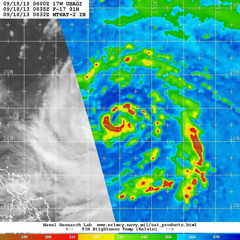
Waiting for new microwave, but it looks like its really taking off today. Could be an interesting night.
0 likes   

RobWESTPACWX
WestPACMet
WestPACMet
Posts: 1616
Joined: Fri Sep 17, 2010 2:26 am
Location: Tokyo, Japan
Contact:

Re: WPAC: USAGI - Severe Tropical Storm

#44 Postby RobWESTPACWX » Wed Sep 18, 2013 4:48 am

Does that look like a eye forming?

Image
0 likes   
Satellites, Charts and Forecasting tools for East Asia at WESTERNPACIFICWEATHER.COM

User avatar
cycloneye
Admin
Admin
Posts: 139095
Age: 67
Joined: Thu Oct 10, 2002 10:54 am
Location: San Juan, Puerto Rico

Re: WPAC: USAGI - Tropical Storm

#45 Postby cycloneye » Wed Sep 18, 2013 5:18 am

Typhoon Hunter wrote:
cycloneye wrote:Hi James,are you planning to chase Usagi in Taiwan?


Hi Luis, too early to tell right now, models are swinging around a bit but threat of direct landfall on S Taiwan looks to have diminished somewhat. GFS and ECMWF hinting at a potential threat to HK so I'd want to be here if anything rolled this way (after the Vicente incident last year!!)

The latest ECMWF has especially got my attention, 96 hours out:

http://img593.imageshack.us/img593/7568/aisp.png

Uploaded with ImageShack.us


Yes, I think is better for you to stay in HK now as track goes away from Taiwan. HK is well in landfall probability and with that ECMWF run yikes!
0 likes   
Visit the Caribbean-Central America Weather Thread where you can find at first post web cams,radars
and observations from Caribbean basin members Click Here

RL3AO
Moderator-Pro Met
Moderator-Pro Met
Posts: 16308
Joined: Thu Jun 14, 2007 10:03 pm
Location: NC

#46 Postby RL3AO » Wed Sep 18, 2013 6:27 am

F. T4.0/4.0/D2.0/24HRS

Very impressive. Deepened two T#s in 24 hours (although I personally think it was a 2.5 yesterday).

Its trying to close off an eye. Looks better and better on satellite. I think a 100kt typhoon this time tomorrow is not out of the question.

EDIT: Oh wow.

Image

Maybe 100 knots is likely this time tomorrow. Something stronger may not be out of the question to be honest.

Personal Forecast Disclaimer:
The posts in this forum are NOT official forecast and should not be used as such. They are just the opinion of the poster and may or may not be backed by sound meteorological data. They are NOT endorsed by any professional institution or storm2k.org. For official information, please refer to the JMA and JTWC products.
0 likes   

User avatar
euro6208
Category 5
Category 5
Posts: 18547
Joined: Mon Mar 08, 2004 7:50 pm
Location: Guam

Re: WPAC: USAGI - Severe Tropical Storm

#47 Postby euro6208 » Wed Sep 18, 2013 6:52 am

Image


CI# /Pressure/ Vmax
3.7 / 985.0mb/ 59.0kt


Final T# Adj T# Raw T#
3.7 4.2 5.6

rapid strengthening occuring...

this looks like a solid category 2 typhoon right now...
0 likes   
Remember, all of my post aren't official. For official warnings and discussions, Please refer to your local NWS products...

NWS for the Western Pacific

https://www.weather.gov/gum/

RL3AO
Moderator-Pro Met
Moderator-Pro Met
Posts: 16308
Joined: Thu Jun 14, 2007 10:03 pm
Location: NC

#48 Postby RL3AO » Wed Sep 18, 2013 6:54 am

Not very often you see a raw T that much different than the final T. I think we could be witnessing quite a 24 hour period starting about four hours ago.

I'm seeing a T4.0 both with curved banding technique and the eye technique.

If I had to make a guess

T+0: 65kt
T+12: 80kt
T+24: 105kt


Personal Forecast Disclaimer:
The posts in this forum are NOT official forecast and should not be used as such. They are just the opinion of the poster and may or may not be backed by sound meteorological data. They are NOT endorsed by any professional institution or storm2k.org.
0 likes   

User avatar
euro6208
Category 5
Category 5
Posts: 18547
Joined: Mon Mar 08, 2004 7:50 pm
Location: Guam

Re: WPAC: USAGI - Severe Tropical Storm

#49 Postby euro6208 » Wed Sep 18, 2013 7:51 am

CI# /Pressure/ Vmax
4.3 / 976.0mb/ 72.2kt


Final T# Adj T# Raw T#
4.3 4.3 5.8
0 likes   
Remember, all of my post aren't official. For official warnings and discussions, Please refer to your local NWS products...

NWS for the Western Pacific

https://www.weather.gov/gum/

RL3AO
Moderator-Pro Met
Moderator-Pro Met
Posts: 16308
Joined: Thu Jun 14, 2007 10:03 pm
Location: NC

#50 Postby RL3AO » Wed Sep 18, 2013 8:00 am

Very fascinating storm on satellite. Continues to look better with each new image.
0 likes   

User avatar
HURAKAN
Professional-Met
Professional-Met
Posts: 46086
Age: 37
Joined: Thu May 20, 2004 4:34 pm
Location: Key West, FL
Contact:

#51 Postby HURAKAN » Wed Sep 18, 2013 8:29 am

Image

Image

beautiful storm
0 likes   

User avatar
SouthDadeFish
Professional-Met
Professional-Met
Posts: 2835
Joined: Thu Sep 23, 2010 2:54 pm
Location: Miami, FL
Contact:

Re: WPAC: USAGI - Typhoon

#52 Postby SouthDadeFish » Wed Sep 18, 2013 8:36 am

The internal structure is there. Once the eye clears out, Dvorak numbers will skyrocket.
0 likes   

RL3AO
Moderator-Pro Met
Moderator-Pro Met
Posts: 16308
Joined: Thu Jun 14, 2007 10:03 pm
Location: NC

#53 Postby RL3AO » Wed Sep 18, 2013 8:40 am

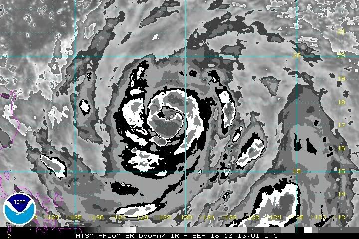
This is one of the most interesting looking IR storms I've seen in a while.


Image
0 likes   

User avatar
mrbagyo
Category 5
Category 5
Posts: 3614
Age: 31
Joined: Thu Apr 12, 2012 9:18 am
Location: 14.13N 120.98E
Contact:

Re: WPAC: USAGI - Typhoon

#54 Postby mrbagyo » Wed Sep 18, 2013 8:44 am

ahhh. I bet we'll have a major typhoon by tomorrow. ... this is such a beautiful typhoon.
the eye is clearing up and I expect Usagi to reach its peak before it enters the channel between Taiwan and Luzon Island..

Image

Personal Forecast Disclaimer:
The posts in this forum are NOT official forecast and should not be used as such. They are just the opinion of the poster and may or may not be backed by sound meteorological data. They are NOT endorsed by any professional institution or storm2k.org. For official information, please refer to the JMA products.
Last edited by mrbagyo on Wed Sep 18, 2013 8:50 am, edited 1 time in total.
0 likes   
The posts in this forum are NOT official forecast and should not be used as such. They are just the opinion of the poster and may or may not be backed by sound meteorological data. They are NOT endorsed by any professional institution or storm2k.org. For official information, please refer to RSMC, NHC and NWS products.

User avatar
euro6208
Category 5
Category 5
Posts: 18547
Joined: Mon Mar 08, 2004 7:50 pm
Location: Guam

Re: WPAC: USAGI - Typhoon

#55 Postby euro6208 » Wed Sep 18, 2013 8:47 am

too bad we don't have recon anymore...looks like another severely underestimated storm with dvorak and weather agencies catching up...
0 likes   
Remember, all of my post aren't official. For official warnings and discussions, Please refer to your local NWS products...

NWS for the Western Pacific

https://www.weather.gov/gum/

User avatar
Extratropical94
Professional-Met
Professional-Met
Posts: 3535
Age: 29
Joined: Wed Oct 20, 2010 6:36 am
Location: Hamburg, Germany
Contact:

#56 Postby Extratropical94 » Wed Sep 18, 2013 8:51 am

Latest SSD advanced Dvorak estimate:
2013SEP18 130100 4.6 970.6 79.6 4.6 5.7 6.5 1.7T/6hr OFF OFF -20.69 -76.00 EYE 13 IR N/A 17.47 -129.29 COMBO MTSAT2 27.3

Current satellite estimate: 80 knots 1-min
Raw T-number: 127 knots 1-min
0 likes   
54° 11' 59'' N, 9° 9' 20'' E
Boomer Sooner!
Go Broncos! Go Cards! Go Niners!
- Daniel

RL3AO
Moderator-Pro Met
Moderator-Pro Met
Posts: 16308
Joined: Thu Jun 14, 2007 10:03 pm
Location: NC

#57 Postby RL3AO » Wed Sep 18, 2013 8:53 am

Those warmer clouds inside the main band are keeping the numbers down. However, the constraints are there for a reason. This was a legitimate T3.5 six hours ago. As good as it looks, this is not a category 3/4 storm right now. Maybe its 80 to 85 knots? Will it be 100 knots in 12 hours? I see no reason for it not to be.

However, because of those warmer clouds around the eye, I think ADT will be a better estimator for the next few hours.
0 likes   

User avatar
Extratropical94
Professional-Met
Professional-Met
Posts: 3535
Age: 29
Joined: Wed Oct 20, 2010 6:36 am
Location: Hamburg, Germany
Contact:

Re:

#58 Postby Extratropical94 » Wed Sep 18, 2013 9:01 am

RL3AO wrote:Those warmer clouds inside the main band are keeping the numbers down. However, the constraints are there for a reason. This was a legitimate T3.5 six hours ago. As good as it looks, this is not a category 3/4 storm right now. Maybe its 80 to 85 knots? Will it be 100 knots in 12 hours? I see no reason for it not to be.

However, because of those warmer clouds around the eye, I think ADT will be a better estimator for the next few hours.


That's why it's good that the CI index doesn't immediately catch up to those high raw T-numbers. The structural improvements need a few hours to actually lead to a significant increase in wind speeds but this thing is definitely becoming a real threat to Luzon and Taiwan as it might end up stronger than forecasted.

Personal Forecast Disclaimer:
The posts in this forum are NOT official forecast and should not be used as such. They are just the opinion of the poster and may or may not be backed by sound meteorological data. They are NOT endorsed by any professional institution or storm2k.org. For official information, please refer to the NHC and NWS products.
0 likes   
54° 11' 59'' N, 9° 9' 20'' E
Boomer Sooner!
Go Broncos! Go Cards! Go Niners!
- Daniel

User avatar
Extratropical94
Professional-Met
Professional-Met
Posts: 3535
Age: 29
Joined: Wed Oct 20, 2010 6:36 am
Location: Hamburg, Germany
Contact:

#59 Postby Extratropical94 » Wed Sep 18, 2013 9:08 am

1500Z JTWC forecast

Image
0 likes   
54° 11' 59'' N, 9° 9' 20'' E
Boomer Sooner!
Go Broncos! Go Cards! Go Niners!
- Daniel

Typhoon Hunter
WesternPacificWeather.com
Posts: 1215
Age: 40
Joined: Wed Oct 11, 2006 11:37 am
Location: Hong Kong
Contact:

Re: WPAC: USAGI - Typhoon

#60 Postby Typhoon Hunter » Wed Sep 18, 2013 9:10 am

I couldn't help myself :D

Ingrid on the left at 75kts, Usagi on the right 65kts

Image

Uploaded with ImageShack.us
0 likes   
James - Documenting typhoons...

http://www.youtube.com/TyphoonHunter


Return to “2013”

Who is online

Users browsing this forum: No registered users and 11 guests