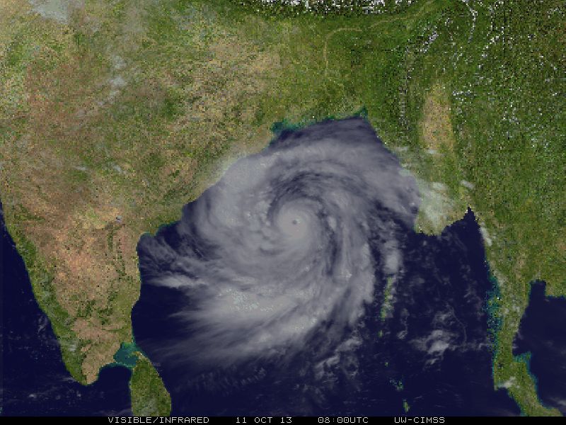
Yeah, beautifully constructed storm. And it fits the BoB like a glove.
BOB : Cyclonic Storm PHAILIN (02B)
Moderator: S2k Moderators
-
ozonepete
- Professional-Met

- Posts: 4743
- Joined: Mon Sep 07, 2009 3:23 pm
- Location: From Ozone Park, NYC / Now in Brooklyn, NY
Re: BOB : Very Severe Cyclonic Storm PHAILIN (02B)
Yeah, beautifully constructed storm. And it fits the BoB like a glove.
0 likes
-
ozonepete
- Professional-Met
- Posts: 4743
- Joined: Mon Sep 07, 2009 3:23 pm
- Location: From Ozone Park, NYC / Now in Brooklyn, NY
Re: BOB : Very Severe Cyclonic Storm PHAILIN (02B)
0 likes
-
supercane4867
- Category 5

- Posts: 4966
- Joined: Wed Nov 14, 2012 10:43 am
Re: BOB : Very Severe Cyclonic Storm PHAILIN (02B)
http://www.weatherphotos.co.za/internat ... hotos.html with some photoshop work
0 likes
-
HURAKAN

- Professional-Met
- Posts: 46086
- Age: 37
- Joined: Thu May 20, 2004 4:34 pm
- Location: Key West, FL
- Contact:
Re: BOB : Very Severe Cyclonic Storm PHAILIN (02B)
supercane4867 wrote:http://www.weatherphotos.co.za/international-satellite_photos.html with some photoshop work
Thanks, great site!
0 likes

Re: BOB : Very Severe Cyclonic Storm PHAILIN (02B)
REMARKS:
110300Z POSITION NEAR 16.0N 88.4E.
TROPICAL CYCLONE (TC) 02B (PHAILIN), LOCATED APPROXIMATELY 409 NM
SOUTH OF KOLKATA, INDIA, HAS TRACKED WEST-NORTHWESTWARD AT 06 KNOTS
OVER THE PAST SIX HOURS. ANIMATED ENHANCED INFRARED (EIR) SATELLITE
IMAGERY SHOWS THE INTENSE CYCLONE HAS MAINTAINED A SYMMETRIC EYE AS
IT CONTINUED TO RAPIDLY INTENSIFY. ADDITIONALLY, A SERIES OF
MICROWAVE IMAGES, INCLUDING A 102343Z SSMI/S PASS, SHOWS THE SYSTEM
IS UNDERGOING AN EYEWALL REPLACEMENT CYCLE, COMMONLY OBSERVED IN
TROPICAL CYCLONES WITH MINIMUM SUSTAINED WIND SPEEDS OF 120 KNOTS.
THE INITIAL POSITION IS BASED ON THE EIR ANIMATION WITH HIGH
CONFIDENCE. THE INITIAL INTENSITY IS BASED ON CONGRUENT DVORAK
INTENSITY ESTIMATES FROM PGTW AND KNES. UPPER LEVEL ANALYSIS
INDICATES THE SYSTEM IS APPROXIMATELY FIVE DEGREES SOUTH OF THE RIDGE
AXIS IN AN AREA OF LOW (05 TO 10 KNOT) VERTICAL WIND SHEAR AND
EXCELLENT RADIAL OUTFLOW. TC PHAILIN IS TRACKING ALONG THE SOUTHERN
PERIPHERY OF THE DEEP-LAYERED SUBTROPICAL RIDGE TO THE NORTHEAST. TC
02B IS FORECAST TO TRACK WEST-NORTHWEST ACROSS THE BAY OF BENGAL AND
MAKE LANDFALL NORTHEAST OF VISAKHAPATNAM, INDIA, BEFORE TAU 36. THE
SYSTEM WILL CONTINUE TO INTENSIFY, REACHING A PEAK OF 145 KNOTS OVER
THE NEXT 24 HOURS AS FAVORABLE CONDITIONS PERSIST. AFTER LANDFALL, TC
PHAILIN WILL RAPIDLY ERODE AS IT TRACKS ACROSS THE RUGGED TERRAIN OF
NORTHERN INDIA, DISSIPATING BY TAU 72. THE AVAILABLE NUMERIC TRACK
GUIDANCE IS IN TIGHT AGREEMENT, LENDING HIGH CONFIDENCE TO THE JTWC
TRACK FORECAST THAT IS LAID CLOSE TO MULTI-MODEL CONSENSUS.
MAXIMUM SIGNIFICANT WAVE HEIGHT AT 110000Z IS 52 FEET. NEXT WARNINGS
AT 110900Z, 111500Z, 112100Z AND 120300Z. //
NNNN
0 likes
Remember, all of my post aren't official. For official warnings and discussions, Please refer to your local NWS products...
NWS for the Western Pacific
https://www.weather.gov/gum/
NWS for the Western Pacific
https://www.weather.gov/gum/
-
HurricaneBill
- Category 5
- Posts: 3420
- Joined: Sun Apr 11, 2004 5:51 pm
- Location: East Longmeadow, MA, USA
Re: BOB : Very Severe Cyclonic Storm PHAILIN (02B)
The last cyclone of hurricane intensity to hit India was Cyclone Thane in December 2011.

However, the last cyclone of Category 2 intensity or higher to hit India was the 1999 Orissa* Cyclone (5B).

*As of November 2011, Orissa is now known as Odisha.
However, the last cyclone of Category 2 intensity or higher to hit India was the 1999 Orissa* Cyclone (5B).
*As of November 2011, Orissa is now known as Odisha.
0 likes

Off topic refer to above post. HUMMMMMMMMMM
1999 Odisha cyclone
The 1999 Odisha cyclone, also known as Cyclone 05B, and Paradwip cyclone, was the deadliest tropical cyclone in the Indian Ocean since the 1991 Bangladesh cyclone, and deadliest Indian storm since 1971. The Category Five storm made landfall just weeks after a category 4 storm hit the same general area.
A tropical depression formed over the Malay Peninsula on October 25. It moved to the northwest and became a tropical storm on October 26. It continued to strengthen into a cyclone on October 27. On October 28, it became a severe cyclone with a peak of 190 mph (305 km/h) winds. It hit India the next day as a 155 mph (250 km/h) cyclone. It caused the deaths of 15,000 people, and heavy to extreme damage in its path of destruction.
0 likes
-
hurricanes1234
- Category 5
- Posts: 2903
- Joined: Sat Jul 28, 2012 6:19 pm
- Location: Trinidad and Tobago
Best Track up to a Category 5!!! 
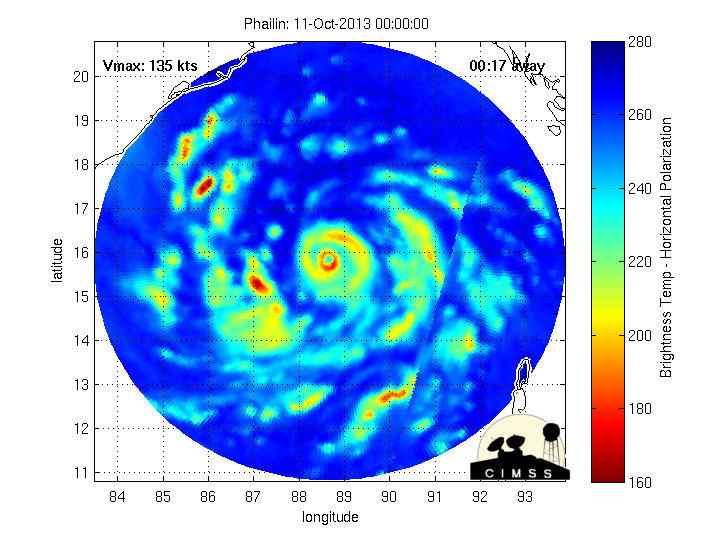
02B PHAILIN 131011 1200 16.7N 87.7E IO 140 918
02B PHAILIN 131011 1200 16.7N 87.7E IO 140 918
0 likes
PLEASE NOTE: With the exception of information from weather agencies that I may copy and paste here, my posts will NEVER be official, since I am NOT a meteorologist. They are solely my amateur opinion, and may or may not be accurate. Therefore, please DO NOT use them as official details, particularly when making important decisions. Thank you.
-
wxman57

- Moderator-Pro Met

- Posts: 22482
- Age: 66
- Joined: Sat Jun 21, 2003 8:06 pm
- Location: Houston, TX (southwest)
Re: BOB : Very Severe Cyclonic Storm PHAILIN (02B)
IMD is predicting only a 3 ft surge from Phailin. Seems a little low. Here's a link to the image. Give it about 5 minutes to load, as their website appears to be connected to a 300 baud modem.
http://www.imd.gov.in/section/nhac/dynamic/surge.jpg
http://www.imd.gov.in/section/nhac/dynamic/surge.jpg
0 likes

Re: BOB : Very Severe Cyclonic Storm PHAILIN (02B)
We know which side of the world is favorable this year.
0 likes
-
supercane4867
- Category 5
- Posts: 4966
- Joined: Wed Nov 14, 2012 10:43 am
-
hurricanes1234
- Category 5
- Posts: 2903
- Joined: Sat Jul 28, 2012 6:19 pm
- Location: Trinidad and Tobago
Re: BOB : Very Severe Cyclonic Storm PHAILIN (02B)
Very amazing cyclone. Cyclone Phailin...

0 likes
PLEASE NOTE: With the exception of information from weather agencies that I may copy and paste here, my posts will NEVER be official, since I am NOT a meteorologist. They are solely my amateur opinion, and may or may not be accurate. Therefore, please DO NOT use them as official details, particularly when making important decisions. Thank you.
-
mrbagyo

- Category 5
- Posts: 3614
- Age: 31
- Joined: Thu Apr 12, 2012 9:18 am
- Location: 14.13N 120.98E
- Contact:
Re: BOB : Very Severe Cyclonic Storm PHAILIN (02B)
mrbagyo wrote:let's see if it can pull a Gay-ish intensification once over the Indian Ocean.
Phailin did. what an impressive storm...
0 likes
The posts in this forum are NOT official forecast and should not be used as such. They are just the opinion of the poster and may or may not be backed by sound meteorological data. They are NOT endorsed by any professional institution or storm2k.org. For official information, please refer to RSMC, NHC and NWS products.
-
hurricanes1234
- Category 5
- Posts: 2903
- Joined: Sat Jul 28, 2012 6:19 pm
- Location: Trinidad and Tobago
Re: BOB : Very Severe Cyclonic Storm PHAILIN (02B)
Monstrously intense tropical cyclone - second strongest of 2013 so far - Category 5 on Saffir-Simpson Scale.
Winds: 1-min sustained 140 knots (~160 mph\260 km/h)
Minimum central pressure: 918 mbar
I think this should set at least some type of record. Don't think there was any storm this intense in the Bay of Bengal since the 21st century began.


Winds: 1-min sustained 140 knots (~160 mph\260 km/h)
Minimum central pressure: 918 mbar
I think this should set at least some type of record. Don't think there was any storm this intense in the Bay of Bengal since the 21st century began.
0 likes
PLEASE NOTE: With the exception of information from weather agencies that I may copy and paste here, my posts will NEVER be official, since I am NOT a meteorologist. They are solely my amateur opinion, and may or may not be accurate. Therefore, please DO NOT use them as official details, particularly when making important decisions. Thank you.
-
supercane4867
- Category 5
- Posts: 4966
- Joined: Wed Nov 14, 2012 10:43 am
Re: BOB : Very Severe Cyclonic Storm PHAILIN (02B)
EWRC had completed and new eyewall contracting as the storm continue to intensify
http://tropic.ssec.wisc.edu/real-time/mimic-tc/2013_02B/webManager/gifsBy12hr_03.gif

Massive storm
http://tropic.ssec.wisc.edu/real-time/mimic-tc/2013_02B/webManager/gifsBy12hr_03.gif
Massive storm
Last edited by supercane4867 on Fri Oct 11, 2013 10:09 am, edited 1 time in total.
0 likes
-
galaxy401

- Category 5
- Posts: 2299
- Age: 28
- Joined: Sat Aug 25, 2012 9:04 pm
- Location: Casa Grande, Arizona
Re: BOB : Very Severe Cyclonic Storm PHAILIN (02B)
hurricanes1234 wrote:Monstrously intense tropical cyclone - second strongest of 2013 so far - Category 5 on Saffir-Simpson Scale.
Winds: 1-min sustained 140 knots (~160 mph\260 km/h)
Minimum central pressure: 918 mbar
Is that the IMD, JTWC, or Dvorak that has this intensity?
0 likes
Got my eyes on moving right into Hurricane Alley: Florida.
-
supercane4867
- Category 5
- Posts: 4966
- Joined: Wed Nov 14, 2012 10:43 am
Re: BOB : Very Severe Cyclonic Storm PHAILIN (02B)
galaxy401 wrote:hurricanes1234 wrote:Monstrously intense tropical cyclone - second strongest of 2013 so far - Category 5 on Saffir-Simpson Scale.
Winds: 1-min sustained 140 knots (~160 mph\260 km/h)
Minimum central pressure: 918 mbar
Is that the IMD, JTWC, or Dvorak that has this intensity?
That should be the offical intensity from JTWC
0 likes
-
hurricanes1234
- Category 5
- Posts: 2903
- Joined: Sat Jul 28, 2012 6:19 pm
- Location: Trinidad and Tobago
Re: BOB : Very Severe Cyclonic Storm PHAILIN (02B)
galaxy401 wrote:hurricanes1234 wrote:Monstrously intense tropical cyclone - second strongest of 2013 so far - Category 5 on Saffir-Simpson Scale.
Winds: 1-min sustained 140 knots (~160 mph\260 km/h)
Minimum central pressure: 918 mbar
Is that the IMD, JTWC, or Dvorak that has this intensity?
JTWC.
0 likes
PLEASE NOTE: With the exception of information from weather agencies that I may copy and paste here, my posts will NEVER be official, since I am NOT a meteorologist. They are solely my amateur opinion, and may or may not be accurate. Therefore, please DO NOT use them as official details, particularly when making important decisions. Thank you.
Who is online
Users browsing this forum: No registered users and 37 guests