ATL: ERIKA - Remnants - Discussion

Moderator: S2k Moderators

Message
Author
User avatar
Gustywind
Category 5
Category 5
Posts: 12334
Joined: Mon Sep 03, 2007 7:29 am
Location: Baie-Mahault, GUADELOUPE

Re: ATL: INVEST 98L - Discussion - 8 AM TWO=90%-90%

#101 Postby Gustywind » Mon Aug 24, 2015 8:07 am

ouragans wrote:When is the next ASCAT pass? I think that's what the NHC waits for to upgrade to TD5

Ouragans what are your best guess related to 98L? Remember given the latest weather forecasts our Pro Mets of Meteo-France expect a perturbation that you could concern Guadeloupe Friday or Saturday. Any ideas about 98L? Thanks :)
0 likes   

User avatar
Gustywind
Category 5
Category 5
Posts: 12334
Joined: Mon Sep 03, 2007 7:29 am
Location: Baie-Mahault, GUADELOUPE

#102 Postby Gustywind » Mon Aug 24, 2015 8:38 am

With 98L showing signs of developpement and the other twave more east the Atlantic tropical wave conveyor belt is in full working order.


http://www.weather.com/storms/hurricane ... antic-2015


Several hundred miles west of the Cape Verde Islands is an area of low pressure that is swirling westward. The National Hurricane Center says that there is a high chance that this system, dubbed Invest 98-L, will develop into a tropical depression early this week. By midweek, this system may move to a position near or north of the Leeward Islands. Just like we saw with Danny, Invest 98-L will have to battle dry air and wind shear nearby as it tries to organize.

Behind that area of low pressure is a tropical wave that has moved off the west coast of Africa. The National Hurricane Center is giving this system a low chance of developing over the next five days. By late week, this system should be located over the central Atlantic Ocean.

It's far too early to know at this time what impacts these systems may bring to the eastern Caribbean or anywhere else. Check back with The Weather Channel and weather.com for updates during the week ahead.
0 likes   

User avatar
gatorcane
S2K Supporter
S2K Supporter
Posts: 23499
Age: 46
Joined: Sun Mar 13, 2005 3:54 pm
Location: Boca Raton, FL

#103 Postby gatorcane » Mon Aug 24, 2015 8:43 am

98L is a much larger system than Danny ever was, so probably why the models are not showing the same outcome that Danny is facing. This wide view puts things in perspective.

Image
0 likes   

User avatar
Gustywind
Category 5
Category 5
Posts: 12334
Joined: Mon Sep 03, 2007 7:29 am
Location: Baie-Mahault, GUADELOUPE

#104 Postby Gustywind » Mon Aug 24, 2015 8:49 am

A New System Emerges Behind Danny
weather.com

Posted: Aug 24 2015 08:49 AM EDT

Updated: Aug 24 2015 08:49 AM EDT

Meteorologist Ari Sarsalari has the latest on another system following Danny.

:rarrow: http://www.weather.com/storms/hurricane ... hind-danny

http://www.weather.com/storms/hurricane :darrow:
Elsewhere in the Atlantic:

Satellite images today show Invest 98-L becoming better organized. It is likely to become a tropical depression by Monday. For much of this week, this system will follow a similar track as Danny. If this system gets a name it will be Erika.

0 likes   

User avatar
tropicwatch
Category 5
Category 5
Posts: 3205
Age: 60
Joined: Sat Jun 02, 2007 10:01 am
Location: Panama City Florida
Contact:

#105 Postby tropicwatch » Mon Aug 24, 2015 9:01 am

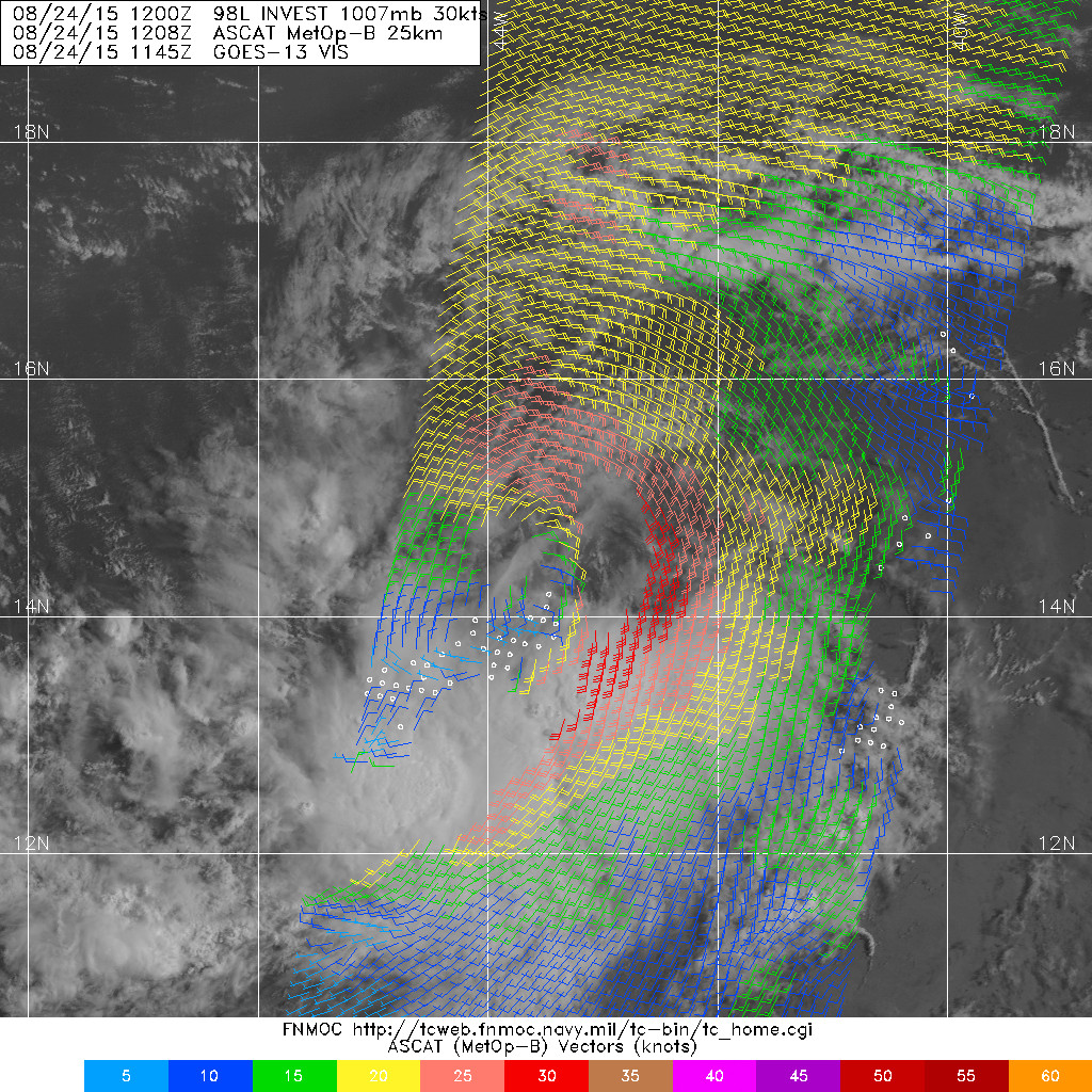
ASCAT

Image
0 likes   
Tropicwatch


Agnes 72', Eloise 75, Elena 85', Kate 85', Charley 86', Florence 88', Beryl 94', Dean 95', Erin 95', Opal 95', Earl 98', Georges 98', Ivan 2004', Arlene 2005', Dennis 2005', Ida 2009' Debby 2012' Irma 2017' Michael 2018'

User avatar
drezee
S2K Supporter
S2K Supporter
Posts: 3644
Joined: Mon Jun 09, 2003 12:49 pm
Location: FL

#106 Postby drezee » Mon Aug 24, 2015 9:03 am

Mid level is quite a bit south of the point of the most LL turning(not LLC yet). They would have to co-locate for any hope of ramping up. If this does not happen soon, then the south track will be more accurate.
0 likes   

User avatar
Gustywind
Category 5
Category 5
Posts: 12334
Joined: Mon Sep 03, 2007 7:29 am
Location: Baie-Mahault, GUADELOUPE

#107 Postby Gustywind » Mon Aug 24, 2015 9:18 am

From Accuweather.com


New Tropical System to Brew in the Atlantic This Week

By Brett Rathbun, AccuWeather.com Meteorologist

August 24, 2015; 8:33 AM ET


:rarrow: http://www.accuweather.com/en/weather-n ... r/51998686

As Danny tracks across the Caribbean, a new disturbance over the Atlantic, currently identified as 98L, will likely become the next tropical depression early this week.

According to AccuWeather Hurricane Expert Dan Kottlowski, "We expect the disturbance to become Tropical Storm Erika later Monday or Tuesday."


This system will be steered westward by a large dome of high pressure across the Atlantic during much of this week.

"This developing system will likely follow the track of Danny and approach the Leeward Islands later this week," AccuWeather Senior Meteorologist Matt Rinde said.

This system is currently located about halfway between Africa and the Windward Islands of the Caribbean in an area of warm water and moist air.

The environment ahead of this system is enriched with moisture recently left from Danny.
0 likes   

User avatar
Gustywind
Category 5
Category 5
Posts: 12334
Joined: Mon Sep 03, 2007 7:29 am
Location: Baie-Mahault, GUADELOUPE

#108 Postby Gustywind » Mon Aug 24, 2015 9:28 am

Loosing slight latitude at each position while moving west faster...


DATE/TIME LAT LON CLASSIFICATION STORM
24/1145 UTC 13.4N 42.0W T1.5/1.5 98L
24/0545 UTC 13.5N 40.6W T1.5/1.5 98L
23/2345 UTC 13.6N 39.2W T1.0/1.0 98L
0 likes   

User avatar
ouragans
Category 1
Category 1
Posts: 466
Age: 52
Joined: Sun Jun 12, 2011 12:09 pm
Location: Abymes, Guadeloupe F.W.I
Contact:

Re: ATL: INVEST 98L - Discussion - 8 AM TWO=90%-90%

#109 Postby ouragans » Mon Aug 24, 2015 9:38 am

Gustywind wrote:
ouragans wrote:When is the next ASCAT pass? I think that's what the NHC waits for to upgrade to TD5

Ouragans what are your best guess related to 98L? Remember given the latest weather forecasts our Pro Mets of Meteo-France expect a perturbation that you could concern Guadeloupe Friday or Saturday. Any ideas about 98L? Thanks :)


Hi my friend.
My guess on this is a weak cat.1 not far from us, or a top-end TS. This is a large system, which should take some time to get together, and some time to be destroyed by the wall of windshear. Overall, it moves very quickly. It may break that wall and slam into the NE islands by thursday. We wanted rain, there it comes.

Did you see I was not far from 100pct with Danny? :wink:
0 likes   
Personal forecast disclaimer
This post is a personal point of view, not an information. Please refer to official statements for life-threatening decisions.

David '79, Frederic '79, Hugo '89, Iris, Luis & Marilyn '95, Georges '98, Lenny '99, Dean '07, Irma '17, Maria '17, Fiona '22, Philippe '23, Tammy '23
16°13'33.3,"6N -61°36'39.5"W

EyELeSs1
Tropical Storm
Tropical Storm
Posts: 220
Joined: Sat May 03, 2003 11:09 pm
Location: Antigua, W.I

Re: ATL: INVEST 98L - Discussion

#110 Postby EyELeSs1 » Mon Aug 24, 2015 9:44 am

Looks like low level vort is displaced far to the north of the MLC. Doubt there will be an upgrade anytime soon.

Image
0 likes   

User avatar
cycloneye
Admin
Admin
Posts: 139463
Age: 67
Joined: Thu Oct 10, 2002 10:54 am
Location: San Juan, Puerto Rico

Re: ATL: INVEST 98L - Discussion

#111 Postby cycloneye » Mon Aug 24, 2015 9:55 am

Until both align there will not be upgrade.But is a matter of time before the circulations join and then will be liftoff.
0 likes   
Visit the Caribbean-Central America Weather Thread where you can find at first post web cams,radars
and observations from Caribbean basin members Click Here

Alyono
Professional-Met
Professional-Met
Posts: 6961
Joined: Fri Apr 26, 2013 3:52 pm
Location: Texas Coast

#112 Postby Alyono » Mon Aug 24, 2015 10:00 am

no imminent development based upon the poor level of organization. As I said, this likely has to wait a few days
0 likes   

tolakram
Admin
Admin
Posts: 19172
Age: 60
Joined: Sun Aug 27, 2006 8:23 pm
Location: Florence, KY (name is Mark)

#113 Postby tolakram » Mon Aug 24, 2015 10:03 am

0 likes   
M a r k
- - - - -
Join us in chat: Storm2K Chatroom Invite. Android and IOS apps also available.

The posts in this forum are NOT official forecasts and should not be used as such. Posts are NOT endorsed by any professional institution or STORM2K.org. For official information and forecasts, please refer to NHC and NWS products.

User avatar
Blown Away
S2K Supporter
S2K Supporter
Posts: 9868
Joined: Wed May 26, 2004 6:17 am

Re:

#114 Postby Blown Away » Mon Aug 24, 2015 10:14 am

Alyono wrote:no imminent development based upon the poor level of organization. As I said, this likely has to wait a few days


Currently 98L is just over 72 hours from the islands... I think they will make a call on classifying this sooner than later... 98L is flying!!
0 likes   
Hurricane Eye Experience: David 79, Irene 99, Frances 04, Jeanne 04, Wilma 05... EYE COMING MY WAY IN 2024…
Hurricane Brush Experience: Andrew 92, Erin 95, Floyd 99, Matthew 16, Irma 17, Ian 22, Nicole 22…

Nederlander
S2K Supporter
S2K Supporter
Posts: 1171
Joined: Sat Jul 19, 2008 4:28 pm
Location: Nederland, TX

Re: Re:

#115 Postby Nederlander » Mon Aug 24, 2015 10:20 am

Blown Away wrote:
Alyono wrote:no imminent development based upon the poor level of organization. As I said, this likely has to wait a few days


Currently 98L is just over 72 hours from the islands... I think they will make a call on classifying this sooner than later... 98L is flying!!


I am seeing multiple vorts and as others have said, until we can get consolidation with a stacked llc and mlc, then an upgrade is not likely. It may happen later tonight however.
0 likes   

User avatar
Gustywind
Category 5
Category 5
Posts: 12334
Joined: Mon Sep 03, 2007 7:29 am
Location: Baie-Mahault, GUADELOUPE

Re: ATL: INVEST 98L - Discussion - 8 AM TWO=90%-90%

#116 Postby Gustywind » Mon Aug 24, 2015 10:23 am

ouragans wrote:
Gustywind wrote:
ouragans wrote:When is the next ASCAT pass? I think that's what the NHC waits for to upgrade to TD5

Ouragans what are your best guess related to 98L? Remember given the latest weather forecasts our Pro Mets of Meteo-France expect a perturbation that you could concern Guadeloupe Friday or Saturday. Any ideas about 98L? Thanks :)


Hi my friend.
My guess on this is a weak cat.1 not far from us, or a top-end TS. This is a large system, which should take some time to get together, and some time to be destroyed by the wall of windshear. Overall, it moves very quickly. It may break that wall and slam into the NE islands by thursday. We wanted rain, there it comes.

Did you see I was not far from 100pct with Danny? :wink:

Ok, yeah i noticied that concerning you % with Danny :). Ok for 98L, yeah we want it but we have not see it. The situation is becoming worrying but we're Lucky compared to others islands like PR. Cycloneye we hope that the next feature could produce some nice rain for you like Msbee :). Keeping our fingers crossed. :D
0 likes   

User avatar
cycloneye
Admin
Admin
Posts: 139463
Age: 67
Joined: Thu Oct 10, 2002 10:54 am
Location: San Juan, Puerto Rico

Re: ATL: INVEST 98L - Discussion

#117 Postby cycloneye » Mon Aug 24, 2015 10:32 am

Updated 12z Best Track increase winds to TS strength at 35kts so if this is upgraded it will skip TD status to then be Tropical Storm Erika.


Location: 14.2°N 43.6°W
Maximum Winds: 35 kt Gusts: N/A
Minimum Central Pressure: 1006 mb
Environmental Pressure: 1011 mb
Radius of Circulation: 180 NM
Radius of Maximum Wind: 50 NM


0 likes   
Visit the Caribbean-Central America Weather Thread where you can find at first post web cams,radars
and observations from Caribbean basin members Click Here

User avatar
TheStormExpert
Category 5
Category 5
Posts: 8487
Age: 30
Joined: Wed Feb 16, 2011 5:38 pm
Location: Palm Beach Gardens, FL

#118 Postby TheStormExpert » Mon Aug 24, 2015 10:36 am

I still think until 98L slows down it will struggle to develop much.

My question now is when is it going to slow down if at all?

2000th post BTW! :D
0 likes   
The following post is NOT an official forecast and should not be used as such. It is just the opinion of the poster and may or may not be backed by sound meteorological data. It is NOT endorsed by storm2k.org.

User avatar
SouthFLTropics
Category 5
Category 5
Posts: 4156
Age: 48
Joined: Thu Aug 14, 2003 8:04 am
Location: Port St. Lucie, Florida

Re: Re:

#119 Postby SouthFLTropics » Mon Aug 24, 2015 10:42 am

Blown Away wrote:
Alyono wrote:no imminent development based upon the poor level of organization. As I said, this likely has to wait a few days


Currently 98L is just over 72 hours from the islands... I think they will make a call on classifying this sooner than later... 98L is flying!!


The fact that it is flying is probably the reason why it is having a harder time consolidating. We've seen this with fast moving systems before. If it gets stacked then it will take off I'm sure, but it may need to slow down in order to do so.

SFT
0 likes   
Fourth Generation Floridian...With lots of storm knowledge passed down from my elders...

Personal Storm History: David 79, Andrew 92, Erin 95, Floyd 99, Irene 99, Frances 04, Jeanne 04, Wilma 05, Matthew 16, Irma 17

User avatar
wxman57
Moderator-Pro Met
Moderator-Pro Met
Posts: 22484
Age: 66
Joined: Sat Jun 21, 2003 8:06 pm
Location: Houston, TX (southwest)

Re: ATL: INVEST 98L - Discussion

#120 Postby wxman57 » Mon Aug 24, 2015 10:59 am

I think that this disturbance will be moving across the NE Caribbean Wednesday night, probably in about the same shape Danny is currently. Could be a struggling TD/TS when it passes (like Danny). Rain will be the primary impact. It's best chance of becoming a strong TS or H will be if it passes north of the Caribbean and recurves toward Bermuda in 8-10 days.
0 likes   


Return to “2015”

Who is online

Users browsing this forum: No registered users and 7 guests