ATL: INVEST 99L - Discussion

Moderator: S2k Moderators

Message
Author
User avatar
NDG
S2K Supporter
S2K Supporter
Posts: 14934
Joined: Sun Jul 09, 2006 10:14 pm
Location: Orlando, FL

Re:

#121 Postby NDG » Sun Sep 27, 2015 8:55 pm

gatorcane wrote:Latest shortwave loop. Looks like the "llc" isn't moving a whole lot. My best guess is a slow NE drift. Looks to have stalled maybe towards the end of the loop:

http://i.imgur.com/fKhmHyx.gif


Yeah, the surface low is not moving much while the convection keeps been pushed away from it.
0 likes   

rickybobby
Tropical Storm
Tropical Storm
Posts: 174
Joined: Fri Sep 18, 2015 11:11 am
Location: Central Florida

Re: Re:

#122 Postby rickybobby » Sun Sep 27, 2015 9:10 pm

NDG wrote:
gatorcane wrote:Latest shortwave loop. Looks like the "llc" isn't moving a whole lot. My best guess is a slow NE drift. Looks to have stalled maybe towards the end of the loop:

http://i.imgur.com/fKhmHyx.gif


Yeah, the surface low is not moving much while the convection keeps been pushed away from it.

What does that mean? Thanks
0 likes   

User avatar
NDG
S2K Supporter
S2K Supporter
Posts: 14934
Joined: Sun Jul 09, 2006 10:14 pm
Location: Orlando, FL

Re: Re:

#123 Postby NDG » Sun Sep 27, 2015 9:20 pm

rickybobby wrote:
NDG wrote:
gatorcane wrote:Latest shortwave loop. Looks like the "llc" isn't moving a whole lot. My best guess is a slow NE drift. Looks to have stalled maybe towards the end of the loop:

http://i.imgur.com/fKhmHyx.gif


Yeah, the surface low is not moving much while the convection keeps been pushed away from it.

What does that mean? Thanks


It cannot organize tropically because the shear keeps pushing the convection away from the surface low center.
0 likes   

User avatar
northjaxpro
S2K Supporter
S2K Supporter
Posts: 8900
Joined: Mon Sep 27, 2010 11:21 am
Location: Jacksonville, FL

#124 Postby northjaxpro » Sun Sep 27, 2015 9:25 pm

:uarrow: This will be the theme I think from here on out. Shear will continually blow away convection away from the LLC. You just can not get a system to organize in the face of such extreme hostile conditions.
0 likes   
NEVER, EVER SAY NEVER in the tropics and weather in general, and most importantly, with life itself!!

________________________________________________________________________________________

Fay 2008 Beryl 2012 Debby 2012 Colin 2016 Hermine 2016 Julia 2016 Matthew 2016 Irma 2017 Dorian 2019

Weatherwatcher98
Category 1
Category 1
Posts: 346
Joined: Sat Sep 12, 2015 10:53 am

Re: ATL: INVEST 99L - Discussion

#125 Postby Weatherwatcher98 » Sun Sep 27, 2015 10:00 pm

That is unless a New Center forms east. Like I said, watching the area near 25 that has been persistent
0 likes   
Personal Forecast Disclaimer:
The posts in this forum are NOT official forecast and should not be used as such. They are just the opinion of the poster and may or may not be backed by sound meteorological data. They are NOT endorsed by any professional institution or storm2k.org. For official information, please refer to the NHC and NWS products.

User avatar
N2FSU
S2K Supporter
S2K Supporter
Posts: 1010
Joined: Thu Sep 04, 2003 2:04 pm
Location: Tallahassee, FL

Re: ATL: INVEST 99L - Discussion

#126 Postby N2FSU » Sun Sep 27, 2015 10:21 pm

Convection hanging in there, but relentless shear.

Image
0 likes   

caneman
Category 5
Category 5
Posts: 1178
Joined: Fri Sep 05, 2014 5:44 am
Location: Clearwater Beach, Fl

#127 Postby caneman » Sun Sep 27, 2015 10:54 pm

Anyone else notice that hook?,Looks like it is starting to try.and wrap up at 25.and 86 may have found a pocket of low shear.
0 likes   

User avatar
Hurricaneman
Category 5
Category 5
Posts: 7284
Age: 43
Joined: Tue Aug 31, 2004 3:24 pm
Location: central florida

Re:

#128 Postby Hurricaneman » Sun Sep 27, 2015 10:56 pm

caneman wrote:Anyone else notice that hook?,Looks like it is starting to try.and wrap up at 25.and 86 may have found a pocket of low shear.


Could be a relocation but I have my doubts as I think what you're following is the MLC while the LLC is North of the Yucatan

The posts in this forum are NOT official forecast and should not be used as such. They are just the opinion of the poster and may or may not be backed by sound meteorological data. They are NOT endorsed by any professional institution or storm2k.org. For official information, please refer to the NHC and NWS products
0 likes   

caneman
Category 5
Category 5
Posts: 1178
Joined: Fri Sep 05, 2014 5:44 am
Location: Clearwater Beach, Fl

#129 Postby caneman » Sun Sep 27, 2015 11:00 pm

It may.be.but the llc appears to be getting closer and closer to it. It's more than 50 percents covered with convection now may have found a pocket of lower shear.
0 likes   

User avatar
stormhunter7
Category 2
Category 2
Posts: 733
Joined: Mon May 26, 2008 3:13 pm
Location: Panama City Beach, Florida
Contact:

Re: ATL: INVEST 99L - Discussion

#130 Postby stormhunter7 » Sun Sep 27, 2015 11:15 pm

http://www.ssd.noaa.gov/goes/east/gmex/ir2-animated.gif

maybe my eyes are getting tired, but i think 99L has slowed the NNE movement in the last few hours?
0 likes   
The following post is NOT an official forecast and should not be used as such. It is just the opinion of the poster and may or may not be backed by sound meteorological data. It is NOT endorsed by any professional institution including storm2k.org For Official Information please refer to the NHC and NWS products. http://www.nhc.noaa.gov

Sanibel
Category 5
Category 5
Posts: 10348
Joined: Mon Aug 30, 2004 11:06 pm
Location: Offshore SW Florida

Re: ATL: INVEST 99L - Discussion

#131 Postby Sanibel » Sun Sep 27, 2015 11:15 pm

The Loop Current should maintain what it's doing anyway.
0 likes   

User avatar
northjaxpro
S2K Supporter
S2K Supporter
Posts: 8900
Joined: Mon Sep 27, 2010 11:21 am
Location: Jacksonville, FL

#132 Postby northjaxpro » Mon Sep 28, 2015 12:01 am

:uarrow: The LLC is still to the north of the northern coast of the Yucatan Peninsula with all the significant convection still well removed from the LLC.

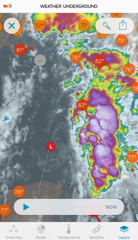
The floater imagery below details well the exposed LLC spinning just north of the northern coast of the Yucatan Peninsula and the deep convection sheared well off to the east and northeast of the LLC. A very hostile environment for 99L which will only get worse as time progresses.

Image
0 likes   
NEVER, EVER SAY NEVER in the tropics and weather in general, and most importantly, with life itself!!

________________________________________________________________________________________

Fay 2008 Beryl 2012 Debby 2012 Colin 2016 Hermine 2016 Julia 2016 Matthew 2016 Irma 2017 Dorian 2019

User avatar
NDG
S2K Supporter
S2K Supporter
Posts: 14934
Joined: Sun Jul 09, 2006 10:14 pm
Location: Orlando, FL

Re:

#133 Postby NDG » Mon Sep 28, 2015 4:43 am

caneman wrote:It may.be.but the llc appears to be getting closer and closer to it. It's more than 50 percents covered with convection now may have found a pocket of lower shear.


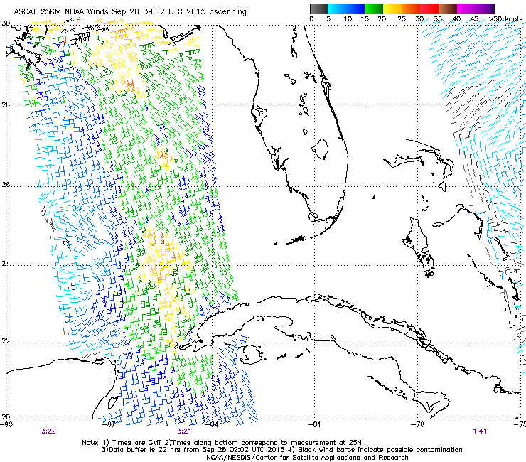
Like many of us write all the time that looks are deceiving, ASCAT showed that the circulation is still broad, no LLC and it is not so close to the convection. Let me repeat myself, no evidence of a defined LLC.

Image
0 likes   

User avatar
NDG
S2K Supporter
S2K Supporter
Posts: 14934
Joined: Sun Jul 09, 2006 10:14 pm
Location: Orlando, FL

#134 Postby NDG » Mon Sep 28, 2015 4:59 am

The surface COC remains weak, broad and elongated this morning.

Image
0 likes   

User avatar
northjaxpro
S2K Supporter
S2K Supporter
Posts: 8900
Joined: Mon Sep 27, 2010 11:21 am
Location: Jacksonville, FL

#135 Postby northjaxpro » Mon Sep 28, 2015 5:04 am

:uarrow: Yes it is very weak and may not be closed off imo as the recent ASCAT shows a faint swirl. It may barely be a discernable COC at this point. The prospects for 99L to me looks bleak as the shear will only get worse as time progresses.
0 likes   
NEVER, EVER SAY NEVER in the tropics and weather in general, and most importantly, with life itself!!

________________________________________________________________________________________

Fay 2008 Beryl 2012 Debby 2012 Colin 2016 Hermine 2016 Julia 2016 Matthew 2016 Irma 2017 Dorian 2019

caneman
Category 5
Category 5
Posts: 1178
Joined: Fri Sep 05, 2014 5:44 am
Location: Clearwater Beach, Fl

Re: Re:

#136 Postby caneman » Mon Sep 28, 2015 6:20 am

NDG wrote:
caneman wrote:It may.be.but the llc appears to be getting closer and closer to it. It's more than 50 percents covered with convection now may have found a pocket of lower shear.


Like many of us write all the time that looks are deceiving, ASCAT showed that the circulation is still broad, no LLC and it is not so close to the convection. Let me repeat myself, no evidence of a defined LLC.

Image
ndg, im not quite sure why you want to keep insisting in many posts that there is no llc. Dont let your early prediction of no development skew what has and is taking place.. There is an llc and has been an llc and i was correct as the 5 am nhc update clearly mentions there is. Im,quite aware that looks can be deceiving. Ive been tracking these for over 15 years. It furthers states there is a moderate chance for development. In addition, the llc is and has been moving in a nne direction. Well see if gets under the convection and what happens then. Im glad to see the nhc verify my thoughts. There is in an llc with a moderate shot at devlopment. I'll go with their word on it and my eyes.
0 likes   

caneman
Category 5
Category 5
Posts: 1178
Joined: Fri Sep 05, 2014 5:44 am
Location: Clearwater Beach, Fl

#137 Postby caneman » Mon Sep 28, 2015 6:37 am

Further, the ull is backing away and im starting to notice popcorning of convection. Im not saying it will develop but conditions look to be becoming.more favorable and the overall structure looks better. Nhc gives it 40 percent but I'd say a 50 50 shot. Imho
0 likes   

User avatar
NDG
S2K Supporter
S2K Supporter
Posts: 14934
Joined: Sun Jul 09, 2006 10:14 pm
Location: Orlando, FL

Re: Re:

#138 Postby NDG » Mon Sep 28, 2015 6:47 am

caneman wrote:
NDG wrote:
caneman wrote:It may.be.but the llc appears to be getting closer and closer to it. It's more than 50 percents covered with convection now may have found a pocket of lower shear.


Like many of us write all the time that looks are deceiving, ASCAT showed that the circulation is still broad, no LLC and it is not so close to the convection. Let me repeat myself, no evidence of a defined LLC.

Image
ndg, im not quite sure why you want to keep insisting in many posts that there is no llc. Dont let your early prediction of no development skew what has and is taking place.. There is an llc and has been an llc and i was correct as the 5 am nhc update clearly mentions there is. Im,quite aware that looks can be deceiving. Ive been tracking these for over 15 years. It furthers states there is a moderate chance for development. In addition, the llc is and has been moving in a nne direction. Well see if gets under the convection and what happens then. Im glad to see the nhc verify my thoughts. There is in an llc with a moderate shot at devlopment. I'll go with their word on it and my eyes.


The evidence that I posted says it all, there's no defined LLC, what you guys were looking at was nothing more than two weak eddies rotating around each other. Now, where's your evidence????
BTW, chances back down to 30%
Last edited by NDG on Mon Sep 28, 2015 6:49 am, edited 1 time in total.
0 likes   

User avatar
cycloneye
Admin
Admin
Posts: 139409
Age: 67
Joined: Thu Oct 10, 2002 10:54 am
Location: San Juan, Puerto Rico

Re: ATL: INVEST 99L - Discussion

#139 Postby cycloneye » Mon Sep 28, 2015 6:47 am

An area of low pressure centered over the south-central Gulf of
Mexico, about 300 miles west of Key West, is producing a large area
of disorganized showers and thunderstorms that extends from western
Cuba northward across the eastern Gulf of Mexico. The circulation
associated with this system has become a little less well defined
since yesterday, and upper-level winds are not favorable for
significant development. The system is expected to move northward
toward the northern Gulf Coast over the next 24 to 36 hours, to the
east of a broader non-tropical area of low pressure located over the
western Gulf of Mexico. An Air Force Reserve reconnaissance
aircraft is scheduled to investigate the low this afternoon, if
necessary. Regardless of whether or not the system becomes a
tropical cyclone, locally heavy rains are likely over portions of
the southeastern United States during the next few days. For
additional information on this system, see High Seas Forecasts
issued by the National Weather Service and products from your local
National Weather Service office.
* Formation chance through 48 hours...low...30 percent
* Formation chance through 5 days...low...30 percent
0 likes   
Visit the Caribbean-Central America Weather Thread where you can find at first post web cams,radars
and observations from Caribbean basin members Click Here

CYCLONE MIKE
Category 5
Category 5
Posts: 2183
Joined: Tue Aug 31, 2004 6:04 pm
Location: Gonzales, LA

Re: ATL: INVEST 99L - Discussion

#140 Postby CYCLONE MIKE » Mon Sep 28, 2015 6:54 am

nhc has actually dropped it down to 30%. Says its weaker and more disorganized since yesterday. Should continue to drop from here on out as shear gets stronger like ndg and northjax have said.

Guess I was a little late for 99l's going away party since cycloneye already posted it 8-)
Last edited by CYCLONE MIKE on Mon Sep 28, 2015 7:04 am, edited 1 time in total.
0 likes   


Return to “2015”

Who is online

Users browsing this forum: No registered users and 5 guests