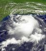
Looking at the RAMMB floater to me it appears to be maintaining, not getting less organized. There is big area of convection building on the SE side and let's see if it can wrap some of that into the LLC. Also looks like there is a hint it could be trying to move slightly more N of due west so could be a sign it may start gaining a little latitude as some of the models have suggested it would:
http://rammb.cira.colostate.edu/ramsdis ... display=12
As an aside, looking at that floater there is another spin further east and yet another cluster of thunderstorms moving off Africa. Activity certainly on the increase in the MDR.
ATL: DANNY - Remnants - Discussion
Moderator: S2k Moderators
-
TheStormExpert

- Category 5

- Posts: 8487
- Age: 30
- Joined: Wed Feb 16, 2011 5:38 pm
- Location: Palm Beach Gardens, FL
One thing for sure is most of the deep convection has been limited to the south of it where the ITCZ is due to dry air/SAL to the north.
0 likes
The following post is NOT an official forecast and should not be used as such. It is just the opinion of the poster and may or may not be backed by sound meteorological data. It is NOT endorsed by storm2k.org.
-
SFLcane

- S2K Supporter

- Posts: 9618
- Age: 46
- Joined: Sat Jun 05, 2010 1:44 pm
- Location: Lake Worth Florida
Re:
Alyono wrote:looking less organized than before. I'd say 20% chance of development. For a US threat, need to look toward Hawaii once again
Agree if it wants to do something it better be soon. Might see naked swirl this evening with all that dry air and strong windshear nearby . This basin is pathetic
0 likes
-
TheStormExpert
- Category 5
- Posts: 8487
- Age: 30
- Joined: Wed Feb 16, 2011 5:38 pm
- Location: Palm Beach Gardens, FL
Re:
gatorcane wrote:Looking at the RAMMB floater to me it appears to be maintaining, not getting less organized. There is big area of convection building on the SE side and let's see if it can wrap some of that into the LLC. Also looks like there is a hint it could be trying to move slightly more N of due west so could be a sign it may start gaining a little latitude as some of the models have suggested it would:
http://rammb.cira.colostate.edu/ramsdis ... display=12
As an aside, looking at that floater there is another spin further east and yet another cluster of thunderstorms moving off Africa. Activity certainly on the increase in the MDR.
Your always interesting to listen to.
By the way do you happen to know if any Kelvin Waves are helping this increase in moisture across the Atlantic and MDR?
0 likes
The following post is NOT an official forecast and should not be used as such. It is just the opinion of the poster and may or may not be backed by sound meteorological data. It is NOT endorsed by storm2k.org.
-
TheStormExpert
- Category 5
- Posts: 8487
- Age: 30
- Joined: Wed Feb 16, 2011 5:38 pm
- Location: Palm Beach Gardens, FL
Re: Re:
SFLcane wrote:Alyono wrote:looking less organized than before. I'd say 20% chance of development. For a US threat, need to look toward Hawaii once again
Agree if it wants to do something it better be soon. Might see naked swirl this evening with all that dry air and strong windshear nearby . This basin is pathetic
What wind shear? Where it is there is only 0-10kts of wind shear.
0 likes
The following post is NOT an official forecast and should not be used as such. It is just the opinion of the poster and may or may not be backed by sound meteorological data. It is NOT endorsed by storm2k.org.
-
Riptide

- Category 2

- Posts: 753
- Age: 32
- Joined: Fri Jul 23, 2010 3:33 pm
- Location: Cape May, New Jersey
- Contact:
Re: ATL: INVEST 96L - Discussion
Even in above-average seasons. You don't see most waves blow up right off the coast. The average longitude of formation is about 50W.
I can only surmise the unwarranted pessimism is from past seasons.
I can only surmise the unwarranted pessimism is from past seasons.
0 likes

Re: ATL: INVEST 96L - Discussion
I would not rule anything out with invest 96L, it may hold it's own for now, but has some potential to increase it's strength. No one can really predict what may happen down the road~! I can see it strengthening into something more potent, we can only watch and wait!
0 likes
-
gatorcane

- S2K Supporter
- Posts: 23499
- Age: 46
- Joined: Sun Mar 13, 2005 3:54 pm
- Location: Boca Raton, FL
Re: Re:
TheStormExpert wrote:gatorcane wrote:Looking at the RAMMB floater to me it appears to be maintaining, not getting less organized. There is big area of convection building on the SE side and let's see if it can wrap some of that into the LLC. Also looks like there is a hint it could be trying to move slightly more N of due west so could be a sign it may start gaining a little latitude as some of the models have suggested it would:
http://rammb.cira.colostate.edu/ramsdis ... display=12
As an aside, looking at that floater there is another spin further east and yet another cluster of thunderstorms moving off Africa. Activity certainly on the increase in the MDR.
Your always interesting to listen to.
By the way do you happen to know if any Kelvin Waves are helping this increase in moisture across the Atlantic and MDR?
Glad somebody finds my comments interesting!
Well looking at this graphic, it appears there is more rising air in the MDR now than we have seen all hurricane season. It might be helping with the increased convection:

Last edited by gatorcane on Mon Aug 17, 2015 10:27 am, edited 2 times in total.
0 likes

Re: ATL: INVEST 96L - Discussion
The problem with this system is the same as simple as climo. If this system heads through the Eastern Caribbean, then the "Columbian heat low" will open it up as the pressure down there are below 1005. It happens time and time again. It has happened to two nice waves this year as well. It would have to be a healthy TS to survive. Also, it would likely have to accelerate during the trek as well (increasing shear). I think the only survivable path is over or north of the Greater Antilles.
Insert Disclaimer:
The posts in this forum are NOT official forecast and should not be used as such. They are just the opinion of the poster and may or may not be backed by sound meteorological data. They are NOT endorsed by any professional institution or storm2k.org. For official information, please refer to the NHC and NWS products.
0 likes
-
Dean4Storms
- S2K Supporter
- Posts: 6355
- Age: 61
- Joined: Sun Aug 31, 2003 1:01 pm
- Location: Miramar Bch. FL

TheStormExpert,
There is an active CCKW phase that is helping with convection across the Atlantic and Africa. This is likely why models have been trying to spin up systems variably. It will remain so throughout this week before suppressed phase may hit. What this does is helps prevent too much sinking air for thunderstorms and systems can pulse convection if shear is not in the way.
There is an active CCKW phase that is helping with convection across the Atlantic and Africa. This is likely why models have been trying to spin up systems variably. It will remain so throughout this week before suppressed phase may hit. What this does is helps prevent too much sinking air for thunderstorms and systems can pulse convection if shear is not in the way.
0 likes
The above post and any post by Ntxw is NOT an official forecast and should not be used as such. It is just the opinion of the poster and may or may not be backed by sound meteorological data. It is NOT endorsed by any professional institution including Storm2k. For official information, please refer to NWS products.
Help support Storm2K!

-
WPBWeather

- S2K Supporter
- Posts: 535
- Age: 65
- Joined: Thu Jul 18, 2013 12:33 pm
Re: Re:
gatorcane wrote:TheStormExpert wrote:gatorcane wrote:Looking at the RAMMB floater to me it appears to be maintaining, not getting less organized. There is big area of convection building on the SE side and let's see if it can wrap some of that into the LLC. Also looks like there is a hint it could be trying to move slightly more N of due west so could be a sign it may start gaining a little latitude as some of the models have suggested it would:
http://rammb.cira.colostate.edu/ramsdis ... display=12
As an aside, looking at that floater there is another spin further east and yet another cluster of thunderstorms moving off Africa. Activity certainly on the increase in the MDR.
Your always interesting to listen to.
By the way do you happen to know if any Kelvin Waves are helping this increase in moisture across the Atlantic and MDR?
Glad somebody finds my comments interesting!
Well looking at this graphic, it appears there is more rising air in the MDR now than we have seen all hurricane season. It might be helping with the increased convection:
I second that! Gatorcane has consistently posted reasoned and appropriate comments for some years now.
0 likes
-
curtadams
- S2K Supporter
- Posts: 1118
- Joined: Sun Aug 28, 2005 7:57 pm
- Location: Orange, California
- Contact:
Re: ATL: INVEST 96L - Discussion
It looks very unlikely to develop to me. When storms develop they tend to pull north, which will move it right into the huge and strong SAL outbreak on it, above it, and in front of it. If it ever gets going it will be immediately asphyxiated. Maybe it could technically qualify as a cyclone for a bit but the NHC doesn't like to name ephemeral midocean storms.
0 likes
-
ninel conde
- Category 5
- Posts: 1245
- Joined: Mon Aug 04, 2008 2:18 pm
satellite looks awfully dry to me. might be a few clouds left by the time it gets to the carib. 0% chance of anything developing of interest.
0 likes
The posts in this forum are NOT official forecast and should not be used as such. They are just the opinion of the poster and may or may not be backed by sound meteorological data. They are NOT endorsed by any professional institution or storm2k.org. For official information, please refer to the NHC and NWS products.
-
tatertawt24
- Category 1

- Posts: 309
- Joined: Wed Oct 24, 2012 12:57 pm
Re: ATL: INVEST 96L - Discussion
What would be the best direction for this thing to go in right now if it wants to stay alive?
0 likes
Personal Forecast Disclaimer:
The posts in this forum are NOT official forecast and should not be used as such. They are just the opinion of the poster and may or may not be backed by sound meteorological data. They are NOT endorsed by any professional institution or storm2k.org. For official information, please refer to the NHC and NWS products.
The posts in this forum are NOT official forecast and should not be used as such. They are just the opinion of the poster and may or may not be backed by sound meteorological data. They are NOT endorsed by any professional institution or storm2k.org. For official information, please refer to the NHC and NWS products.

Re:
gatorcane wrote::uarrow: I wouldn't be so sure about dry air killing this one this time at least not before it gets designated a TD or a TS. 12Z GFS now going with development
Just check out the water vapor loop - there is a large envelope of moisture surrounding this feature - real dry air over near 50-60W now.
0 likes
-
gatorcane
- S2K Supporter
- Posts: 23499
- Age: 46
- Joined: Sun Mar 13, 2005 3:54 pm
- Location: Boca Raton, FL
Stays at 50/70:
000
ABNT20 KNHC 171755
TWOAT
TROPICAL WEATHER OUTLOOK
NWS NATIONAL HURRICANE CENTER MIAMI FL
200 PM EDT MON AUG 17 2015
For the North Atlantic...Caribbean Sea and the Gulf of Mexico:
Shower and thunderstorm activity associated with an area of low
pressure located several hundred miles southwest of the Cape Verde
Islands continues to show signs of organization. Environmental
conditions appear conducive for development over the next several
days, and a tropical depression will likely form by the middle of
the week while the system moves westward or west-northwestward near
15 mph.
* Formation chance through 48 hours...medium...50 percent
* Formation chance through 5 days...high...70 percent
$$
Forecaster Stewart
Last edited by gatorcane on Mon Aug 17, 2015 12:56 pm, edited 1 time in total.
0 likes

-
SFLcane
- S2K Supporter
- Posts: 9618
- Age: 46
- Joined: Sat Jun 05, 2010 1:44 pm
- Location: Lake Worth Florida
Re: Re:
TheStormExpert wrote:SFLcane wrote:Alyono wrote:looking less organized than before. I'd say 20% chance of development. For a US threat, need to look toward Hawaii once again
Agree if it wants to do something it better be soon. Might see naked swirl this evening with all that dry air and strong windshear nearby . This basin is pathetic
What wind shear? Where it is there is only 0-10kts of wind shear.
Ah record Caribbean windshear awaits along with a wall of dry sinking air. I just don't buy those intensity models at all. Already looks to be choking all to familiar seen in this basin now a days.
0 likes
Who is online
Users browsing this forum: No registered users and 3 guests