WPAC: MAYSAK - Post-Tropical

Moderator: S2k Moderators

Message
Author
ejeraldmc
Tropical Storm
Tropical Storm
Posts: 121
Joined: Thu Oct 14, 2010 6:27 pm
Location: Batangas

Re: WPAC: MAYSAK - Typhoon

#421 Postby ejeraldmc » Tue Mar 31, 2015 5:11 pm

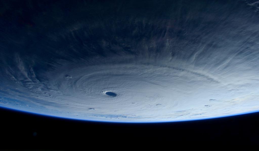
Sam Cristoforetti @AstroSamantha

Commands respect even from #space: we just flew over typhoon #Maysak.

Image

SOURCE: https://twitter.com/astrosamantha
Last edited by ejeraldmc on Tue Mar 31, 2015 5:42 pm, edited 1 time in total.
0 likes   
The above post is not official and should not be used as such. It is the opinion of the poster and may or may not be backed by sound meteorological data. It is not endorsed by any professional institution or storm2k.org. For official information, please refer to the NHC and NWS products.

ejeraldmc
Tropical Storm
Tropical Storm
Posts: 121
Joined: Thu Oct 14, 2010 6:27 pm
Location: Batangas

Re: WPAC: MAYSAK - Typhoon

#422 Postby ejeraldmc » Tue Mar 31, 2015 5:37 pm

Sam Cristoforetti ‏@AstroSamantha

A closer look... #Maysak

Image

Image

Image

Image

SOURCE: https://twitter.com/astrosamantha
Last edited by ejeraldmc on Tue Mar 31, 2015 5:42 pm, edited 2 times in total.
1 likes   
The above post is not official and should not be used as such. It is the opinion of the poster and may or may not be backed by sound meteorological data. It is not endorsed by any professional institution or storm2k.org. For official information, please refer to the NHC and NWS products.

User avatar
Yellow Evan
Professional-Met
Professional-Met
Posts: 15951
Age: 25
Joined: Fri Jul 15, 2011 12:48 pm
Location: Henderson, Nevada/Honolulu, HI
Contact:

#423 Postby Yellow Evan » Tue Mar 31, 2015 5:38 pm

WOW!!!!
0 likes   

HurricaneBill
Category 5
Category 5
Posts: 3420
Joined: Sun Apr 11, 2004 5:51 pm
Location: East Longmeadow, MA, USA

Re: WPAC: MAYSAK - Typhoon

#424 Postby HurricaneBill » Tue Mar 31, 2015 6:26 pm

0 likes   

User avatar
1900hurricane
Category 5
Category 5
Posts: 6044
Age: 32
Joined: Fri Feb 06, 2015 12:04 pm
Location: Houston, TX
Contact:

#425 Postby 1900hurricane » Tue Mar 31, 2015 6:54 pm

Good example of eyewall concentricity.

Image
0 likes   
Contract Meteorologist. TAMU & MSST. Fiercely authentic, one of a kind. We are all given free will, so choose a life meant to be lived. We are the Masters of our own Stories.
Opinions expressed are mine alone.

Follow me on Twitter at @1900hurricane : Read blogs at https://1900hurricane.wordpress.com/

HurricaneTracker2031
Tropical Storm
Tropical Storm
Posts: 248
Age: 24
Joined: Fri Jul 19, 2013 7:20 pm
Location: Pembroke Pines, FL, USA
Contact:

Re: WPAC: MAYSAK - Typhoon

#426 Postby HurricaneTracker2031 » Tue Mar 31, 2015 6:56 pm

Maysak is moving due west now and is still intensifying. Conditions will be worsening for Yap island. People in the path of this should pay close attention. The forecast may change slightly due to more west track.

Image

Analysis for Super Typhoon Maysak: http://goo.gl/QP1cCZ


Personal Forecast Disclaimer:
The posts in this forum are NOT official forecast and should not be used as such. They are just the opinion of the poster and may or may not be backed by sound meteorological data. They are NOT endorsed by any professional institution or storm2k.org. For official information, please refer to the NHC and NWS products.
0 likes   
SHORT VERSION OF DISCLAIMER: THIS SITE LINK BELOW IS NOT AN OFFICIAL FORECASTING OFFICE AND SHOULD NOT BE USED TO MAKE ANY EMERGENCY DECISIONS....

http://www.macstropicalweather.weebly.com

Alyono
Professional-Met
Professional-Met
Posts: 6961
Joined: Fri Apr 26, 2013 3:52 pm
Location: Texas Coast

Re: WPAC: MAYSAK - Typhoon

#427 Postby Alyono » Tue Mar 31, 2015 7:24 pm

clear WNW motion. Likely means good news for the Philippines as it will encounter the strong shear sooner
0 likes   

User avatar
Yellow Evan
Professional-Met
Professional-Met
Posts: 15951
Age: 25
Joined: Fri Jul 15, 2011 12:48 pm
Location: Henderson, Nevada/Honolulu, HI
Contact:

#428 Postby Yellow Evan » Tue Mar 31, 2015 7:24 pm

TXPQ26 KNES 312109
TCSWNP

A. 04W (MAYSAK)

B. 31/2032Z

C. 10.4N

D. 138.2E

E. ONE/MTSAT

F. T7.0/7.0/D1.0/24HRS

G. IR/EIR/SWIR

H. REMARKS...DT=7.0 BASED ON W RING WITH WMG EYE. PT=7.0. MET=7.0. FT
IS BASED ON DT.

I. ADDL POSITIONS

NIL


...SCHWARTZ
0 likes   

User avatar
cycloneye
Admin
Admin
Posts: 139027
Age: 67
Joined: Thu Oct 10, 2002 10:54 am
Location: San Juan, Puerto Rico

Re: WPAC: MAYSAK - Typhoon

#429 Postby cycloneye » Tue Mar 31, 2015 9:14 pm

Image

WDPN31 PGTW 010300
MSGID/GENADMIN/JOINT TYPHOON WRNCEN PEARL HARBOR HI//
SUBJ/PROGNOSTIC REASONING FOR SUPER TYPHOON 04W (MAYSAK) WARNING NR
21//
RMKS/
1. FOR METEOROLOGISTS.
2. 6 HOUR SUMMARY AND ANALYSIS.
SUPER TYPHOON (STY) 04W (MAYSAK), LOCATED APPROXIMATELY 76 NM NORTH-
NORTHWEST OF YAP, HAS TRACKED WEST-NORTHWESTWARD AT 11 KNOTS OVER THE
PAST SIX HOURS. ANIMATED MULTISPECTRAL SATELLITE IMAGERY SHOWS THE
SYSTEM HAS MAINTAINED A 20-NM AXIS-SYMMETRIC EYE THAT IS UNDERGOING
AN ANNULAR CYCLE: THE EYE IS SURROUNDED BY A UNIFORM RING OF DEEP
CONVECTION WITH A LACK OF CONVECTION OUTSIDE THE RING. THIS IS
READILY APPARENT ON A 312213Z 91 GHZ SSMIS COLOR COMPOSITE MICROWAVE
IMAGE. THE INITIAL POSITION IS BASED ON THE EYE FEATURE WITH HIGH
CONFIDENCE. THE INITIAL INTENSITY IS BASED ON AN OVERALL ASSESSMENT
OF CONCENTRIC DVORAK FIXES FROM PGTW, KNES, AND RJTD. UPPER LEVEL
ANALYSIS SHOWS THE SYSTEM IS IN AN AREA OF LOW (05 TO 10 KNOT)
VERTICAL WIND SHEAR (VWS). ADDITIONALLY, THE SYSTEM SUSTAINS ITS OWN
DIVERGENT POINT SOURCE ALOFT THAT IS PROVIDING EXCELLENT RADIAL
OUTFLOW. STY MAYSAK IS TRACKING ALONG THE SOUTHERN PERIPHERY OF THE
DEEP-LAYERED SUBTROPICAL RIDGE (STR) TO THE NORTH.
3. FORECAST REASONING.
A. THERE IS NO CHANGE TO THE FORECAST PHILOSOPHY SINCE THE
PREVIOUS PROGNOSTIC REASONING MESSAGE.
B. STY 04W WILL CONTINUE TRACKING WEST-NORTHWESTWARD UNDER THE
INFLUENCE OF THE STEERING STR THROUGHOUT THE FORECAST PERIOD. AS
FAVORABLE ENVIRONMENTAL CONDITIONS PERSIST IN THE NEAR TERM, STY 04W
WILL LIKELY CONTINUE TO INTENSIFY OVER THE NEXT 12 HOURS, PEAKING AT
150 KNOTS. AFTERWARDS, EXPECT A WEAKENING TREND AS VWS INCREASES WITH
THE APPROACH OF A MID-LATITUDE TROUGH FROM THE NORTHWEST.
C. IN THE EXTENDED TAUS, STY MAYSAK WILL CONTINUE TO WEAKEN AS
IT ENCOUNTERS UPPER-LEVEL CONVERGENCE AND INCREASING VWS ASSOCIATED
WITH THE AFOREMENTIONED TROUGH. HOWEVER, WHEN THE CYCLONE MAKES
LANDFALL SHORTLY NEAR TAU 96 OVER NORTHERN LUZON, PHILIPPINES, NEAR
PALANAN, ISABELA, IT WILL BE AN INTENSE 90-KNOT TYPHOON. MAYSAK WILL
THEN EMERGE IN THE SOUTH CHINA SEA WEAKENED BY THE ROUGH TERRAIN BUT
STILL AT A STRONG TROPICAL STORM INTENSITY. DYNAMIC NUMERICAL MODEL
GUIDANCE REMAINS IN OVERALL TIGHT AGREEMENT, LENDING HIGH CONFIDENCE
IN THE JTWC TRACK FORECAST WHICH IS LAID CLOSE TO THE MULTI-MODEL
CONSENSUS.//
NNNN
0 likes   
Visit the Caribbean-Central America Weather Thread where you can find at first post web cams,radars
and observations from Caribbean basin members Click Here

User avatar
1900hurricane
Category 5
Category 5
Posts: 6044
Age: 32
Joined: Fri Feb 06, 2015 12:04 pm
Location: Houston, TX
Contact:

#430 Postby 1900hurricane » Tue Mar 31, 2015 10:28 pm

Starting to gain even greater confidence that Maysak will really be torn up by shear around 15*N or so. Conditions are and will continue to be really rough up there. Wouldn't be totally surprised with an eventual complete decoupling like what happened with Higos.
0 likes   
Contract Meteorologist. TAMU & MSST. Fiercely authentic, one of a kind. We are all given free will, so choose a life meant to be lived. We are the Masters of our own Stories.
Opinions expressed are mine alone.

Follow me on Twitter at @1900hurricane : Read blogs at https://1900hurricane.wordpress.com/

User avatar
Yellow Evan
Professional-Met
Professional-Met
Posts: 15951
Age: 25
Joined: Fri Jul 15, 2011 12:48 pm
Location: Henderson, Nevada/Honolulu, HI
Contact:

#431 Postby Yellow Evan » Wed Apr 01, 2015 12:18 am

20150401 0232 10.9 -137.2 T6.0/7.0 04W MAYSAK
0 likes   

dexterlabio
Category 5
Category 5
Posts: 3406
Joined: Sat Oct 24, 2009 11:50 pm

#432 Postby dexterlabio » Wed Apr 01, 2015 12:22 am

is this "annular cycle" as stated in the JTWC prognostic the other term for EWRC? Or are they just saying that it's becoming an annular system? Will be very reminiscent of STY Isa if that happens...
0 likes   
Personal Forecast Disclaimer:
The posts in this forum are NOT official forecast and should not be used as such. They are just the opinion of the poster and may or may not be backed by sound meteorological data. They are NOT endorsed by any professional institution or storm2k.org. For official information, please refer to the NHC and NWS products.

dexterlabio
Category 5
Category 5
Posts: 3406
Joined: Sat Oct 24, 2009 11:50 pm

#433 Postby dexterlabio » Wed Apr 01, 2015 12:30 am

Regarding the landfall intensity, I think that will be based on which part of PI it will hit. If it moves further north then I expect it to be around 30-40 knots. If it moves closer to Bicol and south Luzon it could still be a minimal typhoon or STS. I'm inclined not to believe that Maysak picking up annular characteristics will do any help... I've seen annular typhoons decaying quickly because of hostile environment...
0 likes   
Personal Forecast Disclaimer:
The posts in this forum are NOT official forecast and should not be used as such. They are just the opinion of the poster and may or may not be backed by sound meteorological data. They are NOT endorsed by any professional institution or storm2k.org. For official information, please refer to the NHC and NWS products.

User avatar
Yellow Evan
Professional-Met
Professional-Met
Posts: 15951
Age: 25
Joined: Fri Jul 15, 2011 12:48 pm
Location: Henderson, Nevada/Honolulu, HI
Contact:

#434 Postby Yellow Evan » Wed Apr 01, 2015 1:18 am

Cloud tops quite warm, but eye intact. Outflow looks terrible though.
0 likes   

User avatar
euro6208
Category 5
Category 5
Posts: 18547
Joined: Mon Mar 08, 2004 7:50 pm
Location: Guam

Re: WPAC: MAYSAK - Typhoon

#435 Postby euro6208 » Wed Apr 01, 2015 1:34 am

000
WTPQ81 PGUM 010507
HLSPQ1

URGENT - IMMEDIATE BROADCAST REQUESTED
SUPER TYPHOON MAYSAK (04W) LOCAL STATEMENT
NATIONAL WEATHER SERVICE TIYAN GU
300 PM CHST WED APR 1 2015

...SUPER TYPHOON MAYSAK HEADING INTO THE PHILIPPINE SEA...

.AREAS AFFECTED...
THIS LOCAL STATEMENT PROVIDES INFORMATION AND RECOMMENDED ACTIONS
FOR PEOPLE ON YAP AND ULITHI ISLANDS OF YAP STATE.

.WATCHES/WARNINGS...

THE TYPHOON WARNING FOR ULITHI WAS CANCELED AT 1100 AM. DAMAGING
WINDS HAVE ENDED.

THE TYPHOON WARNING FOR YAP ISLAND HAS BEEN CANCELED. DAMAGING WINDS
ARE NO LONGER EXPECTED.

SUMMARY OF 100 PM CHST...0300 UTC...INFORMATION
-----------------------------------------------
LOCATION...10.9N 137.2E

ABOUT 115 MILES NORTHWEST OF YAP
ABOUT 175 MILES WEST-NORTHWEST OF ULITHI
ABOUT 240 MILES WEST-NORTHWEST OF FAIS
ABOUT 540 MILES WEST-SOUTHWEST OF GUAM

MAXIMUM SUSTAINED WINDS...160 MPH
PRESENT MOVEMENT...WEST-NORTHWEST...290 DEGREES AT 13 MPH

.SITUATION OVERVIEW...

SUPER TYPHOON MAYSAK HAS PASSED ALL THE ISLANDS OF YAP STATE...AND
DAMAGING WINDS HAVE ENDED.

...ULITHI...

.PRECAUTIONARY/PREPAREDNESS ACTIONS...
SUPER TYPHOON MAYSAK HAS MOVED FAR ENOUGH AWAY FOR WINDS TO SUBSIDE
BELOW TROPICAL STORM FORCE...BUT SEAS WILL REMAIN HAZARDOUS THE
REST OF THE DAY. DO NOT ATTEMPT INTER-ISLAND TRAVEL OVER THE NEXT
SEVERAL DAYS.

...WIND INFORMATION...
SOUTHWEST WINDS OF 25 TO 35 MPH TODAY WILL SHIFT TO SOUTH AND
DECREASE TO 15 TO 25 MPH BY THIS EVENING.

...STORM SURGE AND SURF INFORMATION...
SEAS WILL SUBSIDE TO BETWEEN 10 AND 13 FEET BY THIS EVENING...AND
CONTINUE TO SLOWLY SUBSIDE OVERNIGHT. PEAK SURF HEIGHTS OF 13 FEET
WILL SUBSIDE TO AROUND 10 FEET TONIGHT.

...OTHER STORM EFFECTS...
NO ADDITIONAL SIGNIFICANT RAINFALL IS EXPECTED.

...YAP...

.PRECAUTIONARY/PREPAREDNESS ACTIONS...
TROPICAL STORM CONDITIONS HAVE ENDED ACROSS YAP...BUT SEAS WILL
REMAIN HAZARDOUS THROUGH TONIGHT. DO NOT ATTEMPT INTER-ISLAND TRAVEL
OVER THE NEXT FEW DAYS.

...WIND INFORMATION...
SOUTHWEST WINDS OF 25 TO 35 MPH THIS AFTERNOON WILL SHIFT TO SOUTH
AND DECREASE TO 15 TO 25 MPH BY THIS EVENING.

...STORM SURGE AND SURF INFORMATION...
COMBINED SEAS 12 TO 15 FT WILL SUBSIDE TO BETWEEN 10 AND 13 FEET
TONIGHT AND CONTINUE TO SLOWLY SUBSIDE OVERNIGHT. DANGEROUS SURF OF
15 TO 18 FEET WILL SUBSIDE TO BELOW 15 FEET THIS EVENING.

...OTHER STORM EFFECTS...
LESS THAN AN INCH OF ADDITIONAL RAINFALL IS EXPECTED THROUGH
TONIGHT.

&&

.NEXT UPDATE...
THIS IS THE LAST LOCAL STATEMENT THAT WILL BE ISSUED BY THE NATIONAL
WEATHER SERVICE ON SUPER TYPHOON MAYSAK.

$$

MIDDLEBROOKE/STANKO
0 likes   
Remember, all of my post aren't official. For official warnings and discussions, Please refer to your local NWS products...

NWS for the Western Pacific

https://www.weather.gov/gum/

dexterlabio
Category 5
Category 5
Posts: 3406
Joined: Sat Oct 24, 2009 11:50 pm

Re: WPAC: MAYSAK - Typhoon

#436 Postby dexterlabio » Wed Apr 01, 2015 2:22 am

down to 130 knots (JTWC).


edit: JMA down to 100 knots.
0 likes   
Personal Forecast Disclaimer:
The posts in this forum are NOT official forecast and should not be used as such. They are just the opinion of the poster and may or may not be backed by sound meteorological data. They are NOT endorsed by any professional institution or storm2k.org. For official information, please refer to the NHC and NWS products.

User avatar
euro6208
Category 5
Category 5
Posts: 18547
Joined: Mon Mar 08, 2004 7:50 pm
Location: Guam

Re: WPAC: MAYSAK - Typhoon

#437 Postby euro6208 » Wed Apr 01, 2015 5:37 am

WDPN31 PGTW 010900
MSGID/GENADMIN/JOINT TYPHOON WRNCEN PEARL HARBOR HI//
SUBJ/PROGNOSTIC REASONING FOR SUPER TYPHOON 04W (MAYSAK) WARNING NR
22//
RMKS/
1. FOR METEOROLOGISTS.
2. 6 HOUR SUMMARY AND ANALYSIS.
SUPER TYPHOON (STY) 04W (MAYSAK), LOCATED APPROXIMATELY 139 NM
NORTHWEST OF YAP, HAS TRACKED WEST-NORTHWESTWARD AT 13 KNOTS OVER
THE PAST SIX HOURS. ANIMATED MULTISPECTRAL SATELLITE IMAGERY SHOWS
THE SYSTEM HAS MAINTAINED ITS 17-NM EYE THAT IS COOLING IN THE
DVORAK HURRICANE CURVE FOR TROPICAL CYCLONE CLASSIFICATION. THE
MICROWAVE RING OF DEEP CONVECTION IS ALSO SHOWING SOME WEAKENING, AS
SEEN IN THE 010548Z SSMI IMAGE. AS SUCH, THE INITIAL INTENSITY HAS
BEEN DROPPED SLIGHTLY TO 130 KNOTS. UPPER LEVEL ANALYSIS CONTINUES
TO DEPICT A FAVORABLE ENVIRONMENT WITH LOW (05 TO 10 KNOT) VERTICAL
WIND SHEAR (VWS) AND A POINT SOURCE DIRECTLY ABOVE THE SYSTEM
PROVIDING EXCELLENT OUTFLOW. STY MAYSAK IS TRACKING ALONG THE
SOUTHERN PERIPHERY OF THE DEEP-LAYERED SUBTROPICAL RIDGE (STR) TO
THE NORTH.
3. FORECAST REASONING.
A. THERE IS NO CHANGE TO THE FORECAST PHILOSOPHY SINCE THE
PREVIOUS PROGNOSTIC REASONING MESSAGE.
B. STY 04W WILL CONTINUE TRACKING NORTHWESTWARD UNDER THE
INFLUENCE OF THE STEERING STR THROUGHOUT THE FORECAST PERIOD. WHILE
FAVORABLE ENVIRONMENTAL CONDITIONS WILL PERSIST, STY 04W WILL LIKELY
MAINTAIN ITS CURRENT INTENSITY OVER THE NEXT 12 HOURS BEFORE
BEGINNING TO WEAKEN DUE TO INCREASED VERTICAL WINDSHEAR. BETWEEN TAU
24 AND 48, EXPECT A SLIGHT POLEWARD MOTION AS THE SYSTEM TRACKS INTO
A SMALL BREAK IN THE STR. FINALLY, THERE WILL INCREASE IN UPPER
LEVEL CONVERGENCE ASSOCIATED WITH THIS SLIGHT SHIFT IN THE SYSTEM,
FURTHER DECREASING THE INTENSITY OF THE SYSTEM.
C. IN THE EXTENDED FORECAST, STY MAYSAK WILL TRACK INTO THE
SIERRA MADRE RANGE ALONG THE NORTHERN SPINE OF LUZON AS A
SIGNIFICANT TYPHOON. WHILE THE SYSTEM WILL DECREASE IN OVERALL
INTENSITY AS IT TRACKS THROUGH CENTRAL LUZON, EXPECT STY MAYSAK TO
RE-EMERGE IN THE SOUTH CHINA SEA AS A SIGNIFICANT TROPICAL STORM.
DYNAMIC NUMERICAL MODEL GUIDANCE REMAINS IN OVERALL TIGHT AGREEMENT,
LENDING HIGH CONFIDENCE IN THE JTWC TRACK FORECAST WHICH IS LAID
CLOSE TO THE MULTI-MODEL CONSENSUS.//
NNNN
0 likes   
Remember, all of my post aren't official. For official warnings and discussions, Please refer to your local NWS products...

NWS for the Western Pacific

https://www.weather.gov/gum/

Alyono
Professional-Met
Professional-Met
Posts: 6961
Joined: Fri Apr 26, 2013 3:52 pm
Location: Texas Coast

Re: WPAC: MAYSAK - Typhoon

#438 Postby Alyono » Wed Apr 01, 2015 9:17 am

I cannot see this having winds of more than 50 kts when it moves through the Philippines given the expected shear. EC and MU are in excellent agreement that this will rapidly weaken on approach. It's already showing signs of weakening now.
0 likes   

dexterlabio
Category 5
Category 5
Posts: 3406
Joined: Sat Oct 24, 2009 11:50 pm

#439 Postby dexterlabio » Wed Apr 01, 2015 9:31 am

JMA forecast might be closer to reality...showing 50-55 knots tropical storm before landfall in Luzon.. JTWC does this stuff.
0 likes   
Personal Forecast Disclaimer:
The posts in this forum are NOT official forecast and should not be used as such. They are just the opinion of the poster and may or may not be backed by sound meteorological data. They are NOT endorsed by any professional institution or storm2k.org. For official information, please refer to the NHC and NWS products.

User avatar
xtyphooncyclonex
Category 5
Category 5
Posts: 3688
Age: 22
Joined: Sat Dec 08, 2012 9:07 am
Location: Cebu City
Contact:

#440 Postby xtyphooncyclonex » Wed Apr 01, 2015 10:03 am

Do not be too confident JUST YET. The amount and magnitude of weakening greatly depends on where it would landfall. Farther south the VWS is much lower and decreasing. Maybe if it hits Northern Luzon, it would be a weak TS at most. If it hits Central Luzon, maybe a strong TS. Lastly if it hits Bicol or Southern Luzon it may be a minimal TY. So still many changes this would encounter.
0 likes   
REMINDER: My opinions that I, or any other NON Pro-Met in this forum, are unofficial. Please do not take my opinions as an official forecast and warning. I am NOT a meteorologist. Following my forecasts blindly may lead to false alarm, danger and risk if official forecasts from agencies are ignored.


Return to “2015”

Who is online

Users browsing this forum: No registered users and 72 guests