ATL: GRACE - Renmants - Discussion
Moderator: S2k Moderators

Re: ATL: INVEST 91L - Discussion
I have learned this is not a great year to hug the models. Lets take it day by day and see what happens. Lets first check to see if it gets stacked right. 
0 likes
The following post is NOT an official forecast and should not be used as such. It is just the opinion of the poster and may or may not be backed by sound meteorological data. It is NOT endorsed by any professional institution including storm2k.org For Official Information please refer to the NHC and NWS products.
-
cycloneye

- Admin

- Posts: 139027
- Age: 67
- Joined: Thu Oct 10, 2002 10:54 am
- Location: San Juan, Puerto Rico
Re: ATL: INVEST 91L - Discussion
blp wrote:I have learned this is not a great year to hug the models. Lets take it day by day and see what happens. Lets first check to see if it gets stacked right.
+100
0 likes
Visit the Caribbean-Central America Weather Thread where you can find at first post web cams,radars
and observations from Caribbean basin members Click Here
and observations from Caribbean basin members Click Here
-
CaliforniaResident
- Tropical Storm

- Posts: 212
- Joined: Fri Feb 21, 2014 1:47 pm
Re: ATL: INVEST 91L - Discussion
cycloneye wrote:blp wrote:I have learned this is not a great year to hug the models. Lets take it day by day and see what happens. Lets first check to see if it gets stacked right.
+100
+1000. What Danny, Erika, and Fred taught us: El Nino is making the Atlantic far more of a wild card than usual. It could peak in the most unexpected places, far overperform, far underperform, etc. I'm going to guess that it WILL definitely make it to TS, hence upping the "count" for the season. However, will it be a "memorable" storm? Odds are "no."
0 likes
-
Gustywind

- Category 5

- Posts: 12334
- Joined: Mon Sep 03, 2007 7:29 am
- Location: Baie-Mahault, GUADELOUPE
Re: ATL: INVEST 91L - Discussion
CaliforniaResident wrote:cycloneye wrote:blp wrote:I have learned this is not a great year to hug the models. Lets take it day by day and see what happens. Lets first check to see if it gets stacked right.
+100
+1000. What Danny, Erika, and Fred taught us: El Nino is making the Atlantic far more of a wild card than usual. It could peak in the most unexpected places, far overperform, far underperform, etc. I'm going to guess that it WILL definitely make it to TS, hence upping the "count" for the season. However, will it be a "memorable" storm? Odds are "no."
+10000

0 likes

Re: ATL: INVEST 91L - Discussion
Gustywind wrote:CaliforniaResident wrote:cycloneye wrote:i advice everybody to be vigilant, don't let your GUARD DOWN.
Boy, that is especially true for those in The Lesser Antilles exhibited by the flooding from Erika.
Sometimes those of us in the CONUS talk "season cancel" and "boring" which might be the case for some but not all.
Good luck Gusty and all of our Island Friends!!
0 likes
Personal Forecast Disclaimer:
My posts are just my opinion and are most likely not backed by sound meteorological data. They are NOT endorsed by any professional institution or storm2k.org. For official information, please refer to the NHC and NWS products.
Bottom line is that I am just expressing my opinion!!!
My posts are just my opinion and are most likely not backed by sound meteorological data. They are NOT endorsed by any professional institution or storm2k.org. For official information, please refer to the NHC and NWS products.
Bottom line is that I am just expressing my opinion!!!
-
cycloneye
- Admin
- Posts: 139027
- Age: 67
- Joined: Thu Oct 10, 2002 10:54 am
- Location: San Juan, Puerto Rico
Re: ATL: INVEST 91L - Discussion
It will be interesting to see if FRED that is again a Tropical Storm affects the track of this system.
0 likes
Visit the Caribbean-Central America Weather Thread where you can find at first post web cams,radars
and observations from Caribbean basin members Click Here
and observations from Caribbean basin members Click Here
-
TheStormExpert

- Category 5
- Posts: 8487
- Age: 30
- Joined: Wed Feb 16, 2011 5:38 pm
- Location: Palm Beach Gardens, FL
2am TWO.
A tropical wave, accompanied by a large area of cloudiness and
thunderstorms, is located a few hundred miles south of the Cape
Verde Islands. This system is gradually becoming better
organized and a tropical depression is likely to form during the
next couple of days while it moves westward at 15 to 20 mph across
the tropical Atlantic.
* Formation chance through 48 hours...high...70 percent
* Formation chance through 5 days...high...80 percent
0 likes
The following post is NOT an official forecast and should not be used as such. It is just the opinion of the poster and may or may not be backed by sound meteorological data. It is NOT endorsed by storm2k.org.
-
Gustywind
- Category 5
- Posts: 12334
- Joined: Mon Sep 03, 2007 7:29 am
- Location: Baie-Mahault, GUADELOUPE
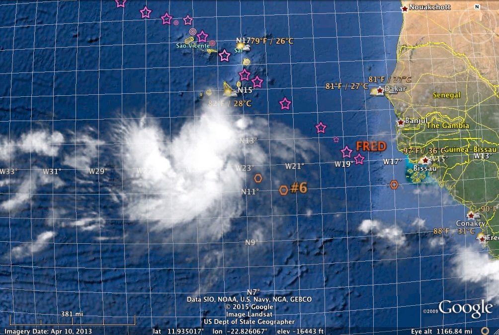
TROPICAL WEATHER DISCUSSION
NWS NATIONAL HURRICANE CENTER MIAMI FL
205 AM EDT SAT SEP 05 2015
A TROPICAL WAVE IS ALONG 21W/22W FROM 19N SOUTHWARD. A 1009 MB
LOW PRESSURE CENTER IS ALONG THE WAVE NEAR 11N. THIS SYSTEM
CONTINUES TO SHOW SIGNS OF ORGANIZATION. IT IS LIKELY THAT A
TROPICAL DEPRESSION MAY FORM DURING THE NEXT COUPLE OF DAYS. THE
CHANCE FOR SUCH DEVELOPMENT IS HIGH...AS THE WAVE MOVES WESTWARD
15 TO 20 KNOTS. CONVECTIVE PRECIPITATION...SCATTERED STRONG IN A
FEW CLUSTERS FROM 11N TO 14N BETWEEN 22W AND 24W...AND FROM 11N
TO 13N BETWEEN 25W AND 26W. ISOLATED MODERATE TO LOCALLY STRONG
ELSEWHERE FROM 08N TO 14N BETWEEN 20W AND 27W.
0 likes
-
Gustywind
- Category 5
- Posts: 12334
- Joined: Mon Sep 03, 2007 7:29 am
- Location: Baie-Mahault, GUADELOUPE
Invest 91-L: Tropical Wave Should Become the Next Atlantic Named Storm
By Quincy Vagell
Published Sep 5 2015 05:32 AM EDT
weather.com
 http://www.weather.com/storms/hurricane ... 5-atlantic
•A tropical wave, designated Invest 91-L, is being monitored in the far eastern Atlantic for possible development into a tropical depression or storm.
•This could occur anytime over the next five days.
•This disturbance is moving west at 15-20 mph and, unlike Fred, is remaining south of the Republic of Cabo Verde.
•It remains far too soon to determine if this system will survive the long journey to the Lesser Antilles, or succumb to dry air and/or wind shear lying ahead.
•The next named storm in the Atlantic basin is "Grace". In an average year, the seventh Atlantic named storm forms by September 16.
By Quincy Vagell
Published Sep 5 2015 05:32 AM EDT
weather.com
•A tropical wave, designated Invest 91-L, is being monitored in the far eastern Atlantic for possible development into a tropical depression or storm.
•This could occur anytime over the next five days.
•This disturbance is moving west at 15-20 mph and, unlike Fred, is remaining south of the Republic of Cabo Verde.
•It remains far too soon to determine if this system will survive the long journey to the Lesser Antilles, or succumb to dry air and/or wind shear lying ahead.
•The next named storm in the Atlantic basin is "Grace". In an average year, the seventh Atlantic named storm forms by September 16.
0 likes
-
cycloneye
- Admin
- Posts: 139027
- Age: 67
- Joined: Thu Oct 10, 2002 10:54 am
- Location: San Juan, Puerto Rico
Re: ATL: INVEST 91L - Discussion
Up to 80%-90%
Satellite images and ship observations this morning indicate that a
tropical depression could be forming about 200 miles south of the
Cape Verde Islands. If this trend continues, advisories would be
initiated later today. Environmental conditions appear to be
favorable for additional development, at least for the next two or
three days, while the system moves westward at 15 to 20 mph across
the tropical Atlantic.
* Formation chance through 48 hours...high...80 percent
* Formation chance through 5 days...high...90 percent
0 likes
Visit the Caribbean-Central America Weather Thread where you can find at first post web cams,radars
and observations from Caribbean basin members Click Here
and observations from Caribbean basin members Click Here
-
Gustywind
- Category 5
- Posts: 12334
- Joined: Mon Sep 03, 2007 7:29 am
- Location: Baie-Mahault, GUADELOUPE
TROPICAL WEATHER DISCUSSION
NWS NATIONAL HURRICANE CENTER MIAMI FL
805 AM EDT SAT SEP 05 2015
A TROPICAL WAVE IS ALONG 22W/23W FROM 19N SOUTHWARD. A 1010 MB
LOW PRESSURE CENTER IS ALONG THE WAVE NEAR 11.5N. THIS SYSTEM
GRADUALLY IS BECOMING BETTER ORGANIZED. IT IS LIKELY THAT A
TROPICAL DEPRESSION MAY FORM DURING THE NEXT COUPLE OF DAYS. THE
CHANCE FOR SUCH DEVELOPMENT IS HIGH...AS THE WAVE MOVES WESTWARD
15 TO 20 KNOTS. CONVECTIVE PRECIPITATION...SCATTERED MODERATE TO
STRONG FROM 11N TO 14N BETWEEN 23W AND 27W.
0 likes
-
toad strangler

- S2K Supporter

- Posts: 4162
- Joined: Sun Jul 28, 2013 3:09 pm
- Location: Earth
- Contact:
-
wxman57

- Moderator-Pro Met

- Posts: 22480
- Age: 66
- Joined: Sat Jun 21, 2003 8:06 pm
- Location: Houston, TX (southwest)
Re: ATL: INVEST 91L - Discussion
There is still very little model support for this system. Moderately hostile conditions in its path for the next few days become very hostile in 5-6 days. I don't think it has much chance of surviving as a TS to reach the Caribbean. However, as Erika has shown, it doesn't take a well-organized major hurricane to produce heavy rainfall. Even a tropical disturbance can produce deadly flooding.
0 likes

-
beoumont

- Category 1

- Posts: 473
- Joined: Sun Jul 10, 2011 4:13 pm
- Location: East Central Florida
- Contact:
Re: ATL: INVEST 91L - Discussion
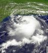
IC1 enhancement:
Last edited by beoumont on Sat Sep 05, 2015 8:36 am, edited 1 time in total.
0 likes
List of 79 tropical cyclones intercepted by Richard Horodner:
http://www.canebeard.com/page/page/572246.htm
http://www.canebeard.com/page/page/572246.htm
-
tolakram
- Admin
- Posts: 19165
- Age: 60
- Joined: Sun Aug 27, 2006 8:23 pm
- Location: Florence, KY (name is Mark)
Re: ATL: INVEST 91L - Discussion
RAMMB Floater
http://rammb.cira.colostate.edu/ramsdis/online/loop_meteosat.asp?data_folder=tropical/tropical_met_4km_visir2_floater&width=640&height=480&number_of_images_to_display=20
source: http://rammb.cira.colostate.edu/ramsdis/online/tropical.asp
http://rammb.cira.colostate.edu/ramsdis/online/loop_meteosat.asp?data_folder=tropical/tropical_met_4km_visir2_floater&width=640&height=480&number_of_images_to_display=20
source: http://rammb.cira.colostate.edu/ramsdis/online/tropical.asp
0 likes
M a r k
- - - - -
Join us in chat: Storm2K Chatroom Invite. Android and IOS apps also available.
The posts in this forum are NOT official forecasts and should not be used as such. Posts are NOT endorsed by any professional institution or STORM2K.org. For official information and forecasts, please refer to NHC and NWS products.
-
northjaxpro

- S2K Supporter
- Posts: 8900
- Joined: Mon Sep 27, 2010 11:21 am
- Location: Jacksonville, FL
91L may develop into Grace prior to 50 degrees longitude. Beyond that point, not much hope for survival with plenty of hostile conditions just waiting to destroy 91L. But, as I echo wxman57's sentiment that the islands need to watch this wave can trigger devastating flooding, so it doesn't matter if this if it is an designated tropical cyclone or not should it reach the islands.
Last edited by northjaxpro on Sat Sep 05, 2015 9:51 am, edited 1 time in total.
0 likes
NEVER, EVER SAY NEVER in the tropics and weather in general, and most importantly, with life itself!!
________________________________________________________________________________________
Fay 2008 Beryl 2012 Debby 2012 Colin 2016 Hermine 2016 Julia 2016 Matthew 2016 Irma 2017 Dorian 2019
________________________________________________________________________________________
Fay 2008 Beryl 2012 Debby 2012 Colin 2016 Hermine 2016 Julia 2016 Matthew 2016 Irma 2017 Dorian 2019
-
cycloneye
- Admin
- Posts: 139027
- Age: 67
- Joined: Thu Oct 10, 2002 10:54 am
- Location: San Juan, Puerto Rico
Re: ATL: SEVEN - Tropical Depression - Discussion
TROPICAL DEPRESSION SEVEN DISCUSSION NUMBER 1
NWS NATIONAL HURRICANE CENTER MIAMI FL AL072015
1100 AM AST SAT SEP 05 2015
Satellite imagery and ship observations indicate that the
disturbance south of the Cape Verde Islands has become better
organized, and is now Tropical Depression Seven. The convection is
not very deep at this time, but animation of visible images show a
good circulation. In fact, earlier microwave data clearly depict a
mid-level center associated with the developing depression. Based on
Dvorak estimates from TAFB and SAB of 2.0 and 2.5, respectively, the
initial intensity has been set at 30 kt. No ASCAT data were
available at the time of this advisory.
The environment appears to be favorable for gradual strengthening
during the next 2 to 3 days. After that time, most of the global
models forecast a significant increase in shear. This should halt
any additional strengthening, and most likely the cyclone will
weaken or could even dissipate well east of the Lesser Antilles.
The best estimate of the initial motion is toward the west or 280
degrees at 12 kt. A moderately strong subtropical ridge is centered
north of the depression. This pattern calls for a continuation of
a general westward track for the next 3 days. After that time,
the ridge is expected to weaken, and the cyclone will likely turn
more toward the west-northwest with a decrease in forward speed.
This is the solution of the models, except the ECMWF that does not
acknowledge the existence of a cyclone.
FORECAST POSITIONS AND MAX WINDS
INIT 05/1500Z 12.3N 25.2W 30 KT 35 MPH
12H 06/0000Z 12.5N 26.9W 30 KT 35 MPH
24H 06/1200Z 12.8N 29.2W 35 KT 40 MPH
36H 07/0000Z 13.0N 32.0W 40 KT 45 MPH
48H 07/1200Z 13.5N 34.7W 45 KT 50 MPH
72H 08/1200Z 14.5N 40.0W 50 KT 60 MPH
96H 09/1200Z 15.0N 45.5W 45 KT 50 MPH
120H 10/1200Z 15.5N 50.0W 40 KT 45 MPH
$$
Forecaster Avila
0 likes
Visit the Caribbean-Central America Weather Thread where you can find at first post web cams,radars
and observations from Caribbean basin members Click Here
and observations from Caribbean basin members Click Here
Who is online
Users browsing this forum: No registered users and 87 guests