ATL: JOAQUIN - Post-Tropical - Discussion

Moderator: S2k Moderators

Message
Author
User avatar
northjaxpro
S2K Supporter
S2K Supporter
Posts: 8900
Joined: Mon Sep 27, 2010 11:21 am
Location: Jacksonville, FL

Re: ATL: INVEST 98L - Discussion

#81 Postby northjaxpro » Sun Sep 27, 2015 9:54 pm

LarryWx wrote:
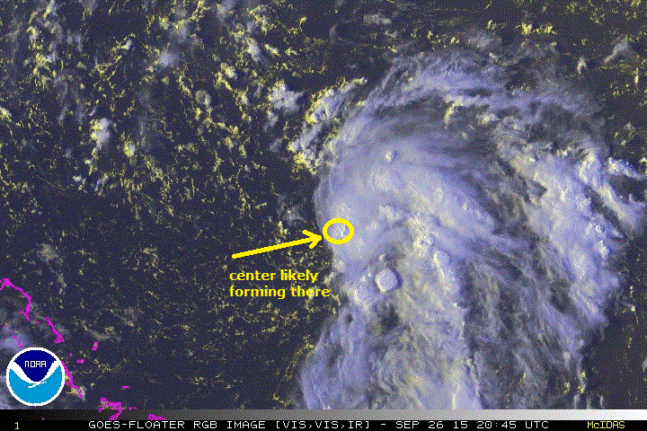
ozonepete wrote:Between this and 99L, this has the best shot to be a TC first imho. Those waters are hot, and it has virtually no shear at all. Even the small amount of dry air to its west and north is diminishing as we speak. The rest of its circulation envelope is very moist. I think this will develop rapidly overnight and tomorrow. It's got "the look."

Image


1) Major kudos to jax for being the one to point out this area way before anyone else here!

2) No model/ens member (that I've seen) has anything close to rapid dev. So, IF this occurs, how should it affect the track? My feeling based on logic and model runs is the further east that is 99L in the GOM, the further E will be this at least below NC because he steering flow would be more N and less NW. The mods are hinting that it stays offshore the US but that it could get close to E NC NNE to E NE. But what if it were to intensify rapidly? Would that mean further offshore the US or something else?


Well thanks fot the props Larry. I really am on here to just offer my insights and educated opinions like most of us. Going back several days ago when this area was a large mid-upper Low spinning north of the Leewards and Puerto Rico, I noticed the periodic convective bursts which seemed abnormal in upper level systems. But, my suspicion increased as the flare up happened a few times late last week. Also, as early as 9/24, the shear analysis forecast out 72 hours showed a window of reduced shear of less than 20 kts to the southwest of Bermuda. I thought with the convective burst off and on occuring that the area had a chance, albeit slight, of potentially burrow itself to the surface. As we know, an upper Low burrowing down to the surface takes quite awhile to occur. But, the ULL was able to interact with a surface trough, which I think helped the system to burrow down to develop a surface reflection this weekend. Also, it found an area of reduced shear in the area it is in now to help it develop.

It is vrry rare to see Upper Level Lows burrow down to the surface. But, for me, it is very interesting to see it happen.
Last edited by northjaxpro on Sun Sep 27, 2015 10:04 pm, edited 1 time in total.
0 likes   
NEVER, EVER SAY NEVER in the tropics and weather in general, and most importantly, with life itself!!

________________________________________________________________________________________

Fay 2008 Beryl 2012 Debby 2012 Colin 2016 Hermine 2016 Julia 2016 Matthew 2016 Irma 2017 Dorian 2019

User avatar
northjaxpro
S2K Supporter
S2K Supporter
Posts: 8900
Joined: Mon Sep 27, 2010 11:21 am
Location: Jacksonville, FL

#82 Postby northjaxpro » Sun Sep 27, 2015 10:02 pm

Right on cue. NHC just now upgraded this to TD 11.
0 likes   
NEVER, EVER SAY NEVER in the tropics and weather in general, and most importantly, with life itself!!

________________________________________________________________________________________

Fay 2008 Beryl 2012 Debby 2012 Colin 2016 Hermine 2016 Julia 2016 Matthew 2016 Irma 2017 Dorian 2019

ozonepete
Professional-Met
Professional-Met
Posts: 4743
Joined: Mon Sep 07, 2009 3:23 pm
Location: From Ozone Park, NYC / Now in Brooklyn, NY

Re: ATL: ELEVEN - Tropical Depression - Discussion

#83 Postby ozonepete » Sun Sep 27, 2015 10:03 pm

From Kimberlain's 11PM discussion: "The depression is expected to be blasted by strong north-northwesterly or northerly winds associated with the tail of an upper-level trough over the central Atlantic beginning on Monday."

Do you think he expects it to survive? :lol:
0 likes   

User avatar
northjaxpro
S2K Supporter
S2K Supporter
Posts: 8900
Joined: Mon Sep 27, 2010 11:21 am
Location: Jacksonville, FL

#84 Postby northjaxpro » Sun Sep 27, 2015 10:09 pm

Well, ozonepete, no matter what happens going forward, which will likely lead to it being ripped to shreads by increased shear, this system has overachieved greatly imo. It managed to do the rare transition from upper level Low to tropical cyclone.
0 likes   
NEVER, EVER SAY NEVER in the tropics and weather in general, and most importantly, with life itself!!

________________________________________________________________________________________

Fay 2008 Beryl 2012 Debby 2012 Colin 2016 Hermine 2016 Julia 2016 Matthew 2016 Irma 2017 Dorian 2019

User avatar
NDG
S2K Supporter
S2K Supporter
Posts: 14933
Joined: Sun Jul 09, 2006 10:14 pm
Location: Orlando, FL

Re:

#85 Postby NDG » Sun Sep 27, 2015 10:12 pm

northjaxpro wrote:Well, ozonepete, no matter what happens going forward, which will likely lead to it being ripped to shreads by increased shear, this system has overachieved greatly imo. It managed to do the rare transition from upper level Low to tropical cyclone.


BTW that was a great call by you a few days ago, the transition is indeed a very rare event we don't see it very often.
0 likes   

User avatar
Hurricaneman
Category 5
Category 5
Posts: 7281
Age: 43
Joined: Tue Aug 31, 2004 3:24 pm
Location: central florida

#86 Postby Hurricaneman » Sun Sep 27, 2015 10:16 pm

The thing is if this get a little farther west than forecast then there will be less shear if it heads a little farther west like 75 or 76W will probably still get torn apart but could strengthen enough that it could still be a tropical cyclone for the NEUS

The posts in this forum are NOT official forecast and should not be used as such. They are just the opinion of the poster and may or may not be backed by sound meteorological data. They are NOT endorsed by any professional institution or storm2k.org. For official information, please refer to the NHC and NWS products
0 likes   

User avatar
northjaxpro
S2K Supporter
S2K Supporter
Posts: 8900
Joined: Mon Sep 27, 2010 11:21 am
Location: Jacksonville, FL

Re: Re:

#87 Postby northjaxpro » Sun Sep 27, 2015 10:18 pm

NDG wrote:
northjaxpro wrote:Well, ozonepete, no matter what happens going forward, which will likely lead to it being ripped to shreads by increased shear, this system has overachieved greatly imo. It managed to do the rare transition from upper level Low to tropical cyclone.


BTW that was a great call by you a few days ago, the transition is indeed a very rare event we don't see it very often.


Yeah, thanks NDG. Just an instinct I had at the time and I stuck my neck out a bit to talk about the possibility pretty much.
0 likes   
NEVER, EVER SAY NEVER in the tropics and weather in general, and most importantly, with life itself!!

________________________________________________________________________________________

Fay 2008 Beryl 2012 Debby 2012 Colin 2016 Hermine 2016 Julia 2016 Matthew 2016 Irma 2017 Dorian 2019

ozonepete
Professional-Met
Professional-Met
Posts: 4743
Joined: Mon Sep 07, 2009 3:23 pm
Location: From Ozone Park, NYC / Now in Brooklyn, NY

Re: Re:

#88 Postby ozonepete » Sun Sep 27, 2015 10:21 pm

northjaxpro wrote:
NDG wrote:Well, ozonepete, no matter what happens going forward, which will likely lead to it being ripped to shreads by increased shear, this system has overachieved greatly imo. It managed to do the rare transition from upper level Low to tropical cyclone.


BTW that was a great call by you a few days ago, the transition is indeed a very rare event we don't see it very often.


Yup let me add you made a great call there northjax. But we expect great things from you. :)
1 likes   

User avatar
Hurricaneman
Category 5
Category 5
Posts: 7281
Age: 43
Joined: Tue Aug 31, 2004 3:24 pm
Location: central florida

#89 Postby Hurricaneman » Sun Sep 27, 2015 10:23 pm

Another thing in my mind is a good analog for this is 1985 Henri which strengthened to a 50mph ts and made landfall on Long Island as a minimal TS and funny enough has a similar projected path and last of all I applaud the NHC for going with a classified system and understand the reasoning of which they went with no strengthening with high shear and mostly what most of the systems have done this year

The posts in this forum are NOT official forecast and should not be used as such. They are just the opinion of the poster and may or may not be backed by sound meteorological data. They are NOT endorsed by any professional institution or storm2k.org. For official information, please refer to the NHC and NWS products
0 likes   

ozonepete
Professional-Met
Professional-Met
Posts: 4743
Joined: Mon Sep 07, 2009 3:23 pm
Location: From Ozone Park, NYC / Now in Brooklyn, NY

Re: ATL: ELEVEN - Tropical Depression - Discussion

#90 Postby ozonepete » Sun Sep 27, 2015 10:24 pm

Still looks to me as if the entire circulation is dropping south-southeast. That will not allow the current forecasts to verify...
0 likes   

User avatar
Hurricaneman
Category 5
Category 5
Posts: 7281
Age: 43
Joined: Tue Aug 31, 2004 3:24 pm
Location: central florida

Re: ATL: ELEVEN - Tropical Depression - Discussion

#91 Postby Hurricaneman » Sun Sep 27, 2015 10:26 pm

ozonepete wrote:Still looks to me as if the entire circulation is dropping south-southeast. That will not allow the current forecasts to verify...


that could cause for more of a chance at some sort of intensification as it would remain in a lower shear enviornment which Southern New England and Long Island don't want to see


The posts in this forum are NOT official forecast and should not be used as such. They are just the opinion of the poster and may or may not be backed by sound meteorological data. They are NOT endorsed by any professional institution or storm2k.org. For official information, please refer to the NHC and NWS products
0 likes   

User avatar
northjaxpro
S2K Supporter
S2K Supporter
Posts: 8900
Joined: Mon Sep 27, 2010 11:21 am
Location: Jacksonville, FL

Re: Re:

#92 Postby northjaxpro » Sun Sep 27, 2015 10:28 pm

ozonepete wrote:
northjaxpro wrote:
NDG wrote:Well, ozonepete, no matter what happens going forward, which will likely lead to it being ripped to shreads by increased shear, this system has overachieved greatly imo. It managed to do the rare transition from upper level Low to tropical cyclone.


BTW that was a great call by you a few days ago, the transition is indeed a very rare event we don't see it very often.


Yup let me add you made a great call there northjax. But we expect great things from you. :)


Appreciate your confidence in me ozonepete!! 8-)
0 likes   
NEVER, EVER SAY NEVER in the tropics and weather in general, and most importantly, with life itself!!

________________________________________________________________________________________

Fay 2008 Beryl 2012 Debby 2012 Colin 2016 Hermine 2016 Julia 2016 Matthew 2016 Irma 2017 Dorian 2019

User avatar
Hurricaneman
Category 5
Category 5
Posts: 7281
Age: 43
Joined: Tue Aug 31, 2004 3:24 pm
Location: central florida

#93 Postby Hurricaneman » Sun Sep 27, 2015 10:58 pm

I wonder if they're going to send recon in tomorrow or tuesday so Im going to start a recon thread for TD11

The posts in this forum are NOT official forecast and should not be used as such. They are just the opinion of the poster and may or may not be backed by sound meteorological data. They are NOT endorsed by any professional institution or storm2k.org. For official information, please refer to the NHC and NWS products
0 likes   

User avatar
Hurricaneman
Category 5
Category 5
Posts: 7281
Age: 43
Joined: Tue Aug 31, 2004 3:24 pm
Location: central florida

ATL: JOAQUIN - Recon

#94 Postby Hurricaneman » Sun Sep 27, 2015 10:59 pm

When are Recon going to fly to TD11
0 likes   

User avatar
Hammy
Category 5
Category 5
Posts: 5594
Age: 40
Joined: Fri May 25, 2012 5:25 pm
Contact:

Re: ATL: ELEVEN - Tropical Depression - Discussion

#95 Postby Hammy » Sun Sep 27, 2015 11:04 pm

http://i.imgur.com/2xWPgbV.png

Center is just outside of the northwestern-most convection, there seems to be no indication of southward movement/reformation. The southwest-northeast oriented line of high clouds associated with earlier outflow is also starting to collapse back towards the southeast indicating the stronger shear has arrived.

edit: With there being a recon scheduled, I'm hoping this can hold out and strengthen over the next few hours to at least add a small amount of ACE, though the low level flow looks worse than six hours ago.
0 likes   
The above post is not official and should not be used as such. It is the opinion of the poster and may or may not be backed by sound meteorological data. It is not endorsed by any professional institution or storm2k.org. For official information, please refer to the NHC and NWS products.

User avatar
Extratropical94
Professional-Met
Professional-Met
Posts: 3535
Age: 29
Joined: Wed Oct 20, 2010 6:36 am
Location: Hamburg, Germany
Contact:

#96 Postby Extratropical94 » Mon Sep 28, 2015 2:01 am

The first aircraft should depart at 10am EDT, and I haven't seen any information yet on whether this might have been already canceled or not.

Code: Select all

    2. SUSPECT AREA (NORTHEAST OF BAHAMAS)
       FLIGHT THREE -- TEAL 78         FLIGHT FOUR -- TEAL 79
       A. 28/1800Z                     A. 29/1130Z
       B. AFXXX 01FFA INVEST           B. AFXXX 0212A CYCLONE
       C. 28/1400Z                     C. 29/0800Z
       D. 28.0N 70.0W                  D. 29.5N 71.5W
       E. 28/1730Z TO 28/2030Z         E. 29/1100Z TO 29/1430Z
       F. SFC TO 10,000FT              F. SFC TO 10,0000FT
       G. RESOURCES PERMITTING

    3. OUTLOOK FOR SUCCEEDING DAY.....CONTINUE 12-HRLY FIXES
       ON SYSTEM NORTHEAST OF BAHAMAS IF SYSTEM DEVELOPS.
0 likes   
54° 11' 59'' N, 9° 9' 20'' E
Boomer Sooner!
Go Broncos! Go Cards! Go Niners!
- Daniel

User avatar
cycloneye
Admin
Admin
Posts: 139069
Age: 67
Joined: Thu Oct 10, 2002 10:54 am
Location: San Juan, Puerto Rico

#97 Postby cycloneye » Mon Sep 28, 2015 5:05 am

TROPICAL DEPRESSION ELEVEN DISCUSSION NUMBER 2
NWS NATIONAL HURRICANE CENTER MIAMI FL AL112015
500 AM AST MON SEP 28 2015

Shortwave and enhanced BD-Curve infrared imagery show little change
in the depression's cloud pattern this morning. Recently,
however, a few bursts of deep convection are beginning to develop
near the surface center. Subjective intensity estimates remain
unchanged from the previous advisory as does the initial intensity
of 30 kt. UW-CIMSS shear product and the SHIPS model both indicate
10-20 kt of northwesterly shear generated by a high amplitude
upper-level ridge extending northward over the western Atlantic from
the western Caribbean. Large-scale models show this upper-wind
pattern persisting through day 3, which should inhibit any
significant strengthening. Afterward, increasing southwesterly
shear is expected to spread over the eastern seaboard and extreme
western Atlantic waters in response to a deep-layer mid-latitude
trough approaching from the west. Despite a rather harsh forecast
upper-wind environment, the IVCN intensity consensus model shows
slight strengthening to a tropical storm in 24 hours. Beyond
the 96 hour period, the global models indicate either dissipation or
the cyclone quickly becoming absorbed by the aforementioned
baroclinic system. The official forecast is based on the IVCN
consensus and indicates the cyclone merging with the frontal system
in 5 days.

The depression's center has been a bit difficult to find this
morning, and has been moving erratically, drifting westward, or
275/2 kt. The cyclone should turn toward the west-northwest
later today and continue in this general direction for a couple
of days due to high pressure extending over the western
Atlantic. After that time, a northward turn is forecast with an
increase in forward speed around day 3 in response to the
above mentioned frontal system approaching the east coast of the
U.S. The NHC track forecast is nudged a little to the left of the
previous forecast and sides with the TVCX multi-model consensus.


FORECAST POSITIONS AND MAX WINDS

INIT 28/0900Z 27.4N 68.9W 30 KT 35 MPH
12H 28/1800Z 27.6N 69.4W 30 KT 35 MPH
24H 29/0600Z 28.0N 70.0W 35 KT 40 MPH
36H 29/1800Z 28.5N 70.7W 35 KT 40 MPH
48H 30/0600Z 29.2N 71.4W 35 KT 40 MPH
72H 01/0600Z 31.2N 72.3W 35 KT 40 MPH
96H 02/0600Z 36.2N 72.5W 30 KT 35 MPH
120H 03/0600Z...ABSORBED BY FRONT

$$
Forecaster Roberts
0 likes   
Visit the Caribbean-Central America Weather Thread where you can find at first post web cams,radars
and observations from Caribbean basin members Click Here

LarryWx
Category 5
Category 5
Posts: 5699
Joined: Sun Sep 07, 2003 2:04 pm
Location: GA

#98 Postby LarryWx » Mon Sep 28, 2015 7:36 am

I'm noting the slower than GFS progged motion of this. Yesterday's 12Z GFS had this already at ~28 N, ~71.2 W and at 1010 mb as of 12Z this morning. Today's 6Z GFS has it as of the same time about 100 miles ESE of there near 27.5 N, 69.8 W and 2 mb stronger. The actual 12Z (8AM EDT) position looks like it will be even further ESE of this 6Z GFS progged position at approximately 27.4 N, 69.3 W, which is about 140 miles ESE of the progged position of yesterday's 12Z GFS. Let's see how much more adjusting ESE will occur over the next few GFS runs and how that impacts its projected track.
0 likes   
Personal Forecast Disclaimer:
The posts in this forum are NOT official forecasts and should not be used as such. They are just the opinion of the poster and may or may not be backed by sound meteorological data. They are NOT endorsed by any professional institution or storm2k.org. For official information, please refer to the NHC and NWS products.

User avatar
NDG
S2K Supporter
S2K Supporter
Posts: 14933
Joined: Sun Jul 09, 2006 10:14 pm
Location: Orlando, FL

#99 Postby NDG » Mon Sep 28, 2015 7:52 am

The LLC of TD 11 is becoming exposed this morning due to the light to moderate NW shear, story of this season, lol.

http://wwwghcc.msfc.nasa.gov/cgi-bin/ge ... umframes=9
0 likes   

LarryWx
Category 5
Category 5
Posts: 5699
Joined: Sun Sep 07, 2003 2:04 pm
Location: GA

#100 Postby LarryWx » Mon Sep 28, 2015 8:01 am

:uarrow: Yep, it is definitely partially exposed. This closeup vis satellite also pretty much confirms where I thought the center was in my post two above this regarding it being ESE of the GFS progs. This also shows it is moving WNW.
0 likes   
Personal Forecast Disclaimer:
The posts in this forum are NOT official forecasts and should not be used as such. They are just the opinion of the poster and may or may not be backed by sound meteorological data. They are NOT endorsed by any professional institution or storm2k.org. For official information, please refer to the NHC and NWS products.


Return to “2015”

Who is online

Users browsing this forum: No registered users and 111 guests