WPAC: LIONROCK - Post-Tropical

Moderator: S2k Moderators

Message
Author
NotoSans
Category 5
Category 5
Posts: 1366
Age: 24
Joined: Sun Sep 27, 2015 1:15 am
Location: Hong Kong
Contact:

Re: WPAC: LIONROCK - Typhoon

#141 Postby NotoSans » Thu Aug 25, 2016 4:22 pm

Lionrock have completed an ERC as suggested by the latest microwave pass. A larger eye is popping out on satellite imagery as well. Still, there appears to be some dry air and it may take some time for Lionrock to mix it out. I would expect some slow to steady intensification in the near term.

Image

Image

JMA and JTWC has come into better agreement in their forecast track as well. The latest Euro run remains consistent but has shifted slightly eastward by about 1 degree longitude. Euro has also trended slightly weaker, but still brings a very powerful typhoon to the Tokyo metropolis.

Image
1 likes   
Personal Forecast Disclaimer:
The posts in this forum are NOT official forecast and should not be used as such. They are just the opinion of the poster and may or may not be backed by sound meteorological data. They are NOT endorsed by any professional institution or storm2k.org. For official information, please refer to RSMC and NWS products.

User avatar
alan1961
Category 2
Category 2
Posts: 767
Joined: Mon Mar 20, 2006 11:58 am
Location: Derby, Derbyshire, England
Contact:

Re: WPAC: LIONROCK - Typhoon

#142 Postby alan1961 » Thu Aug 25, 2016 5:50 pm

Image

The ISS straight over Typhoon Lionrock :wink:
0 likes   

User avatar
terstorm1012
S2K Supporter
S2K Supporter
Posts: 1313
Age: 42
Joined: Fri Sep 10, 2004 5:36 pm
Location: Millersburg, PA

Re: WPAC: LIONROCK - Typhoon

#143 Postby terstorm1012 » Thu Aug 25, 2016 6:04 pm

this could be an amazing typhoon. I'm surprised there aren't more people checking this forum out---it's got a global megacity, a negative tilt. High meteorological drama!
0 likes   

User avatar
Hybridstorm_November2001
S2K Supporter
S2K Supporter
Posts: 2802
Joined: Sat Aug 21, 2004 2:50 pm
Location: SW New Brunswick, Canada
Contact:

Re: WPAC: LIONROCK - Typhoon

#144 Postby Hybridstorm_November2001 » Thu Aug 25, 2016 7:00 pm

I'm following its progress with great interest.
0 likes   

stormwise
Category 2
Category 2
Posts: 590
Joined: Sun Dec 27, 2015 7:39 pm

Re: WPAC: LIONROCK - Typhoon

#145 Postby stormwise » Thu Aug 25, 2016 7:11 pm

12z still locked and loaded.
Image
0 likes   

dexterlabio
Category 5
Category 5
Posts: 3406
Joined: Sat Oct 24, 2009 11:50 pm

Re: WPAC: LIONROCK - Typhoon

#146 Postby dexterlabio » Thu Aug 25, 2016 9:40 pm

Totally forgot last year's Typhoon Goni that hit mainland Japan as a Cat2-3. But if the Euro solution still verifies, this may be a lot stronger. The only things that make me doubt about it is that it is above 20N latitude, and the WPAC is no longer in an El NIno base state.
0 likes   
Personal Forecast Disclaimer:
The posts in this forum are NOT official forecast and should not be used as such. They are just the opinion of the poster and may or may not be backed by sound meteorological data. They are NOT endorsed by any professional institution or storm2k.org. For official information, please refer to the NHC and NWS products.

User avatar
mrbagyo
Category 5
Category 5
Posts: 3614
Age: 31
Joined: Thu Apr 12, 2012 9:18 am
Location: 14.13N 120.98E
Contact:

Re: WPAC: LIONROCK - Typhoon

#147 Postby mrbagyo » Thu Aug 25, 2016 9:47 pm

dexterlabio wrote:Totally forgot last year's Typhoon Goni that hit mainland Japan as a Cat2-3. But if the Euro solution still verifies, this may be a lot stronger. The only things that make me doubt about it is that it is above 20N latitude, and the WPAC is no longer in an El NIno base state.


yeah, it's quite surprising that Japan is experiencing this consecutive hit given that we are supposedly be in a La Nina Year where most storms should generally be west runners. WPAC is kinda drunk

One of my officemate is in Japan, went there just before this storm barrage.. looks like he isn't going anywhere soon.
1 likes   
The posts in this forum are NOT official forecast and should not be used as such. They are just the opinion of the poster and may or may not be backed by sound meteorological data. They are NOT endorsed by any professional institution or storm2k.org. For official information, please refer to RSMC, NHC and NWS products.

dexterlabio
Category 5
Category 5
Posts: 3406
Joined: Sat Oct 24, 2009 11:50 pm

Re: WPAC: LIONROCK - Typhoon

#148 Postby dexterlabio » Thu Aug 25, 2016 9:52 pm

mrbagyo wrote:
dexterlabio wrote:Totally forgot last year's Typhoon Goni that hit mainland Japan as a Cat2-3. But if the Euro solution still verifies, this may be a lot stronger. The only things that make me doubt about it is that it is above 20N latitude, and the WPAC is no longer in an El NIno base state.


yeah, it's quite surprising that Japan is experiencing this consecutive hit given that we are supposedly be in a La Nina Year where most storms should generally be west runners. WPAC is kinda drunk

One of my officemate is in Japan, went there just before this storm barrage.. looks like he isn't going anywhere soon.


Although Lionrock did that rare and steep southwest dip, which I think is a signature track of those storms during a classic La Nina year.. Also, I don't think the atmosphere has started to feel the cooling Pacific water, and the Nino regions have barely exceeded La Nina threshold.
0 likes   
Personal Forecast Disclaimer:
The posts in this forum are NOT official forecast and should not be used as such. They are just the opinion of the poster and may or may not be backed by sound meteorological data. They are NOT endorsed by any professional institution or storm2k.org. For official information, please refer to the NHC and NWS products.

User avatar
mrbagyo
Category 5
Category 5
Posts: 3614
Age: 31
Joined: Thu Apr 12, 2012 9:18 am
Location: 14.13N 120.98E
Contact:

Re: WPAC: LIONROCK - Typhoon

#149 Postby mrbagyo » Thu Aug 25, 2016 9:56 pm

dexterlabio wrote:
mrbagyo wrote:
dexterlabio wrote:Totally forgot last year's Typhoon Goni that hit mainland Japan as a Cat2-3. But if the Euro solution still verifies, this may be a lot stronger. The only things that make me doubt about it is that it is above 20N latitude, and the WPAC is no longer in an El NIno base state.


yeah, it's quite surprising that Japan is experiencing this consecutive hit given that we are supposedly be in a La Nina Year where most storms should generally be west runners. WPAC is kinda drunk

One of my officemate is in Japan, went there just before this storm barrage.. looks like he isn't going anywhere soon.


Although Lionrock did that rare and steep southwest dip, which I think is a signature track of those storms during a classic La Nina year.. Also, I don't think the atmosphere has started to feel the cooling Pacific water, and the Nino regions have barely exceeded La Nina threshold.


Could be a hangover from last year's Nino?
0 likes   
The posts in this forum are NOT official forecast and should not be used as such. They are just the opinion of the poster and may or may not be backed by sound meteorological data. They are NOT endorsed by any professional institution or storm2k.org. For official information, please refer to RSMC, NHC and NWS products.

User avatar
cycloneye
Admin
Admin
Posts: 139069
Age: 67
Joined: Thu Oct 10, 2002 10:54 am
Location: San Juan, Puerto Rico

Re: WPAC: LIONROCK - Typhoon

#150 Postby cycloneye » Thu Aug 25, 2016 10:08 pm

0 likes   
Visit the Caribbean-Central America Weather Thread where you can find at first post web cams,radars
and observations from Caribbean basin members Click Here

stormwise
Category 2
Category 2
Posts: 590
Joined: Sun Dec 27, 2015 7:39 pm

Re: WPAC: LIONROCK - Typhoon

#151 Postby stormwise » Thu Aug 25, 2016 10:37 pm

Typhoon No. 10 (Lion Rock)
2016 08 month 26 day 09 hour 45 minute presentation

<Play-by-play of the hour 26 09>
size -
strength Intense
Presence area South of Minami Daito Island about 290km
Center position North latitude 23 degrees 10 minutes (23.2 degrees)
East longitude 131 degrees 00 minutes (131.0 degrees)
Direction of travel, speed East slowly
Central pressure 945hPa
Maximum wind speed near the center 45m / s (85kt)
Maximum instantaneous wind speed 60m / s (120kt)
25m / s or more of the storm area The entire 90km (50NM)
15m / s or more of the strong wind area The entire 190km (100NM)

<Forecast o'clock 27 09>
strength Intense
Presence area Southeast of Minami Daito Island about 250km
The center of the circle forecast North latitude 24 degrees 00 minutes (24.0 degrees)
East longitude 132 degrees 35 minutes (132.6 degrees)
Direction of travel, speed East-northeast slowly
Central pressure 930hPa
Maximum wind speed near the center 50m / s (100kt)
Maximum instantaneous wind speed 70m / s (140kt)
The radius of the circle forecast 110km (60NM)
Storm warning area The entire 240km (130NM)

<Forecast o'clock 28 09>
strength Ferocious
Presence area East of Minami Daito Island about 430km
The center of the circle forecast North latitude 26 degrees 05 minutes (26.1 degrees)
East longitude 135 degrees 30 minutes (135.5 degrees)
Direction of travel, speed Northeast 15km / h (8kt)
Central pressure 920hPa
Maximum wind speed near the center 55m / s (105kt)
Maximum instantaneous wind speed 75m / s (150kt)
The radius of the circle forecast 200km (110NM)
Storm warning area The entire 330km (180NM)

<Forecast o'clock 29 09>
strength Intense
Presence area Ogasawara waters
The center of the circle forecast North latitude 29 degrees 35 minutes (29.6 degrees)
East longitude 140 degrees 25 minutes (140.4 degrees)
Direction of travel, speed Northeast 25km / h (14kt)
Central pressure 940hPa
Maximum wind speed near the center 45m / s (90kt)
Maximum instantaneous wind speed 65m / s (130kt)
The radius of the circle forecast 410km (220NM)
Storm warning area The entire 540km (290NM)


Ferocious same wording was used for Nepartak
0 likes   

Typhoon Hunter
WesternPacificWeather.com
Posts: 1215
Age: 40
Joined: Wed Oct 11, 2006 11:37 am
Location: Hong Kong
Contact:

Re: WPAC: LIONROCK - Typhoon

#152 Postby Typhoon Hunter » Fri Aug 26, 2016 3:29 am

I just don't see this making 105kts as per JMA forecast - happy to be proved wrong though!
0 likes   
James - Documenting typhoons...

http://www.youtube.com/TyphoonHunter

NotoSans
Category 5
Category 5
Posts: 1366
Age: 24
Joined: Sun Sep 27, 2015 1:15 am
Location: Hong Kong
Contact:

Re: WPAC: LIONROCK - Typhoon

#153 Postby NotoSans » Fri Aug 26, 2016 3:37 am

Lionrock is still having a tough battle with dry air, and the eyewall looks kinda ragged on the latest microwave pass. JMA has slightly lowered their forecast intensity to 100 knots. Still looks a bit aggressive to me though.

Image
0 likes   
Personal Forecast Disclaimer:
The posts in this forum are NOT official forecast and should not be used as such. They are just the opinion of the poster and may or may not be backed by sound meteorological data. They are NOT endorsed by any professional institution or storm2k.org. For official information, please refer to RSMC and NWS products.

stormwise
Category 2
Category 2
Posts: 590
Joined: Sun Dec 27, 2015 7:39 pm

Re: WPAC: LIONROCK - Typhoon

#154 Postby stormwise » Fri Aug 26, 2016 4:53 am

0 likes   

dexterlabio
Category 5
Category 5
Posts: 3406
Joined: Sat Oct 24, 2009 11:50 pm

Re: WPAC: LIONROCK - Typhoon

#155 Postby dexterlabio » Fri Aug 26, 2016 5:00 am

I like how JMA switced from "Violent" to "Ferocious." :lol: Also I remember they used other word than "Violent" back in 2009-2011. I think the word then was "Phenomenal."
0 likes   
Personal Forecast Disclaimer:
The posts in this forum are NOT official forecast and should not be used as such. They are just the opinion of the poster and may or may not be backed by sound meteorological data. They are NOT endorsed by any professional institution or storm2k.org. For official information, please refer to the NHC and NWS products.

stormwise
Category 2
Category 2
Posts: 590
Joined: Sun Dec 27, 2015 7:39 pm

Re: WPAC: LIONROCK - Typhoon

#156 Postby stormwise » Fri Aug 26, 2016 5:03 am

2016 typhoon No. 10, relating to information No. 63 (position)
2016 August 26 day 18 hour 45 minute Japan Meteorological Agency forecast section announcement

(heading)
 very strong typhoon No. 10 is, the south about 310 kilometers Minami Daito Island
we proceed to the east at a speed that is slow.

(Text)
 very strong typhoon No. 10, the 26, 18 and sometimes
Minami Daito Island south of about 310 kilometers
, 00 minutes north latitude 23 degrees, in the east longitude 131 degrees 35 minutes,
we go to the east at a speed that was slowly .
Air pressure in the center is 945 hectopascals
center maximum wind speed of 45 meters around,
the maximum instantaneous wind speed 60 meters in
the within 90 kilometers radius from the center
has become a storm of more than 25 meters wind speed.
In addition, within a 220 km radius from the center
has been blowing in the strong wind is more than 15 meters wind speed.

 The center of the typhoon, 24 hours 27, 18 and sometimes after
Minami Daito Island east-southeast about 310 kilometers of the
north latitude 24 degrees 25 minutes, around the 133 degrees 50 minutes east longitude
is expected to reach a radius of 110 km within the circle.
930 hectopascals of atmospheric pressure center
maximum wind speed of 50 meters near the center,
the maximum instantaneous wind speed is expected to 70 meters.
Is within 240 kilometers radius from the center of the forecast circle
there is a possibility to enter the storm area of more than 25 meters wind speed.
 In addition, the probability that the center of the typhoon to enter the forecast circle is 70%.

Please note the future of typhoon information.
0 likes   

stormwise
Category 2
Category 2
Posts: 590
Joined: Sun Dec 27, 2015 7:39 pm

Re: WPAC: LIONROCK - Typhoon

#157 Postby stormwise » Fri Aug 26, 2016 5:12 am

dexterlabio wrote:I like how JMA switced from "Violent" to "Ferocious." :lol: Also I remember they used other word than "Violent" back in 2009-2011. I think the word then was "Phenomenal."


You just wait if LIONROCK manages to go sub 900. the wording will be supercalifragilisticexpialidocious.
0 likes   

User avatar
euro6208
Category 5
Category 5
Posts: 18547
Joined: Mon Mar 08, 2004 7:50 pm
Location: Guam

Re: WPAC: LIONROCK - Typhoon

#158 Postby euro6208 » Fri Aug 26, 2016 5:26 am

Image

WDPN34 PGTW 260900
MSGID/GENADMIN/JOINT TYPHOON WRNCEN PEARL HARBOR HI//
SUBJ/PROGNOSTIC REASONING FOR TYPHOON 12W (LIONROCK) WARNING NR 34//
RMKS/
1. FOR METEOROLOGISTS.
2. 6 HOUR SUMMARY AND ANALYSIS.
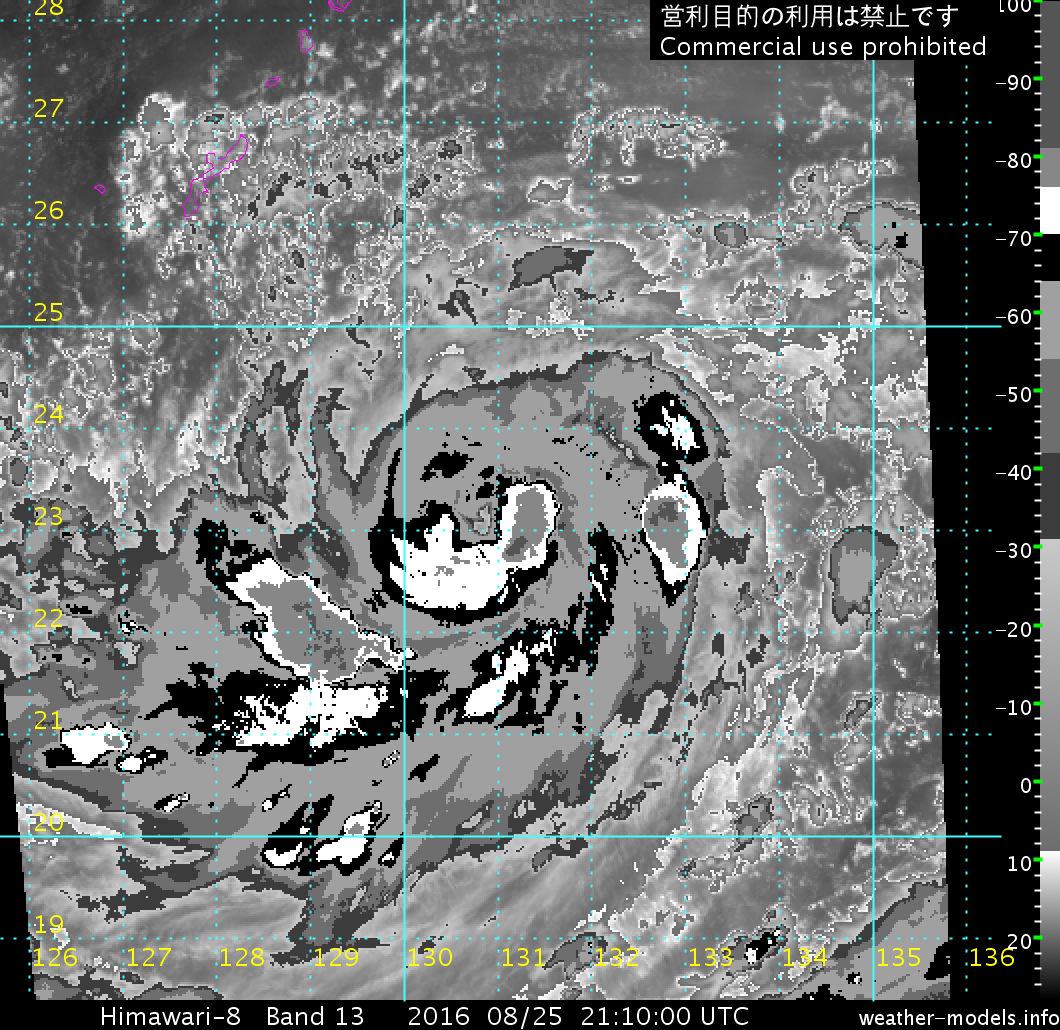
TYPHOON 12W (LIONROCK), LOCATED APPROXIMATELY 279 NM SOUTHEAST OF
KADENA AB, OKINAWA, JAPAN, HAS TRACKED EASTWARD AT 04 KNOTS OVER THE
PAST SIX HOURS. ANIMATED MULTISPECTRAL SATELLITE IMAGERY (MSI) SHOWS
A SYSTEM WITH A WELL-DEFINED 6-NM EYE AND EXCELLENT DUAL OUTFLOW.
BASED ON THE EYE-MOVEMENT, THE SYSTEM HAS BEEN QUASI-STATIONARY AND
HAS, OVERALL, MAINTAINED CONVECTIVE DEPTH. THE INITIAL POSITION IS
BASED ON THE EYE FEATURE IN THE MSI ANIMATION WITH HIGH CONFIDENCE.
THE INITIAL INTENSITY OF 105 KNOTS IS BASED ON CONGRUENT DVORAK
ESTIMATES FROM PGTW, KNES, AND RJTD. UPPER LEVEL ANALYSIS INDICATES
TY 12W IS UNDER A RIDGE AXIS IN AN AREA OF LOW (05-10 KNOT) VERTICAL
WIND SHEAR (VWS). THE CYCLONE IS IN A WEAK STEERING ENVIRONMENT
BETWEEN TWO REFLECTIONS OF THE SUBTROPICAL RIDGE (STR) - ONE TO THE
NORTHWEST AND THE OTHER TO THE EAST-SOUTHEAST.
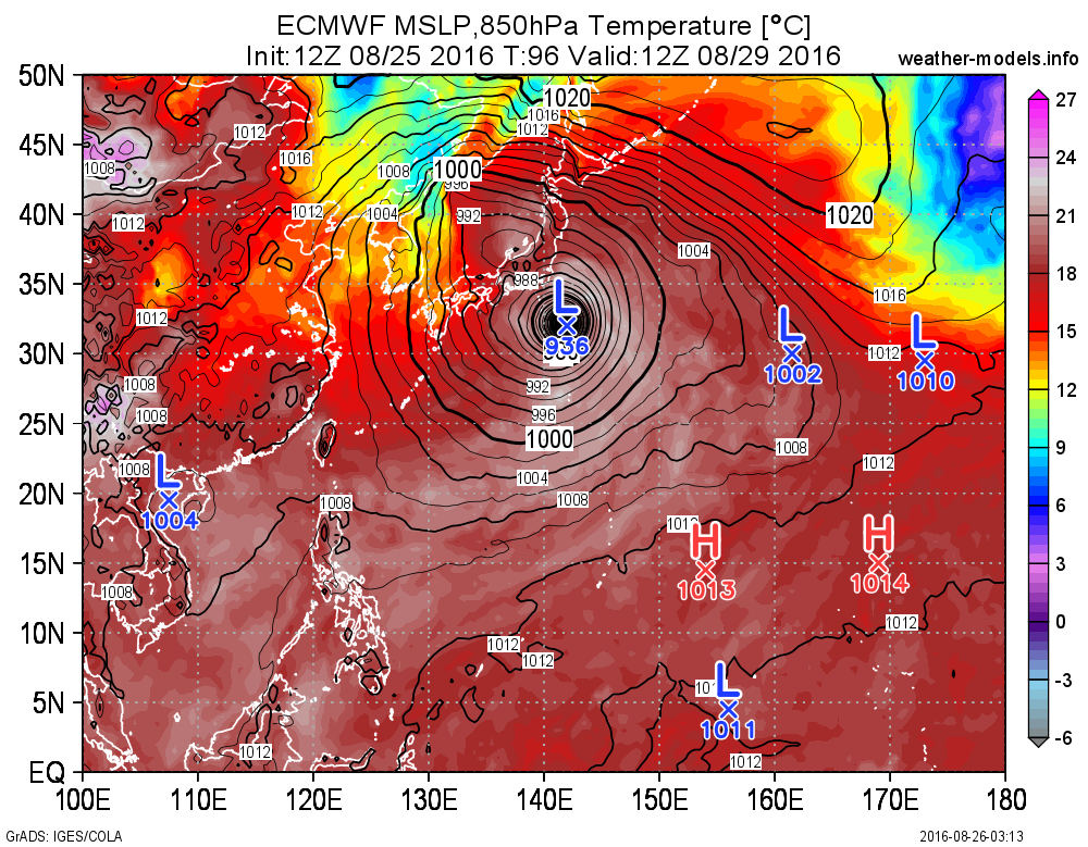
3. FORECAST REASONING.
A. THERE IS NO CHANGE IN THE FORECAST PHILOSOPHY FROM THE PREVIOUS
PROGNOSTIC REASONING MESSAGE.
B. TY 12W WILL BEGIN A SLOW NORTHEAST POLEWARD TRACK AS THE STR TO
THE EAST-SOUTHEAST ASSUMES PRIMARY STEERING. ALTHOUGH SEA SURFACE
TEMPERATURES (SSTS) AT 30 DEGREES CELSIUS AND OUTFLOW REMAIN ROBUST,
INCREASING VWS WILL OFFSET THESE FAVORABLE DYNAMICS AND RESULT IN AN
INTENSITY STAGNATION IN THE NEAR TERM. HOWEVER, BY TAU 36, INCREASED
POLEWARD OUTFLOW DUE TO THE INITIAL EXPOSURE TO THE STRONG WESTERLIES
ASSOCIATED WITH AN APPROACHING MID-LATITUDE TROUGH WILL CAUSE A SMALL
REBOUND IN THE INTENSITY TO 110 KNOTS.
C. IN THE EXTENDED TAUS, TYPHOON LIONROCK WILL BEGIN TO TRACK MORE
NORTHWARD AS ANOTHER REFLECTION OF THE STR ANCHORED AT 45N JUST SOUTH
OF KAMCHATKA BUILDS AND ASSUMES STEERING. INCREASING VWS, COOLING
SSTS, AND TRACK ACROSS THE ISLAND OF HONSHU WILL GRADUALLY WEAKEN THE
CYCLONE DOWN TO 40 KNOTS BY TAU 120. AT TAU 96, THE CYCLONE WILL
ENTER THE BAROCLINIC ZONE AND BEGIN EXTRA-TROPICAL TRANSITION AND
BECOME A COLD-CORE LOW IN THE SEA OF JAPAN BY END OF FORECAST.
NUMERIC GUIDANCE REMAINS WIDELY SPREAD ACROSS THE MODEL ENVELOPE AND
IN THE LATERAL SPEEDS OF EACH SOLUTION. IN VIEW OF THESE, THE
CONFIDENCE IN THE JTWC TRACK FORECAST REMAINS LOW.//
NNNN
0 likes   
Remember, all of my post aren't official. For official warnings and discussions, Please refer to your local NWS products...

NWS for the Western Pacific

https://www.weather.gov/gum/

User avatar
euro6208
Category 5
Category 5
Posts: 18547
Joined: Mon Mar 08, 2004 7:50 pm
Location: Guam

Re: WPAC: LIONROCK - Typhoon

#159 Postby euro6208 » Fri Aug 26, 2016 5:38 am

UW - CIMSS
ADVANCED DVORAK TECHNIQUE
ADT-Version 8.2.1
Tropical Cyclone Intensity Algorithm

----- Current Analysis -----
Date : 26 AUG 2016 Time : 055000 UTC
Lat : 23:07:12 N Lon : 131:14:52 E


CI# /Pressure/ Vmax
5.1 / 954.3mb/ 92.4kt


Final T# Adj T# Raw T#
4.7 4.9 4.9

Estimated radius of max. wind based on IR : 10 km

Center Temp : -20.8C Cloud Region Temp : -59.3C

Scene Type : EYE

Positioning Method : SPIRAL ANALYSIS

Ocean Basin : WEST PACIFIC
Dvorak CI > MSLP Conversion Used : CKZ Method

Tno/CI Rules : Constraint Limits : NO LIMIT
Weakening Flag : ON
Rapid Dissipation Flag : FLAG

C/K/Z MSLP Estimate Inputs :
- Average 34 knot radii : 93km
- Environmental MSLP : 1001mb

Satellite Name : HIM-8
Satellite Viewing Angle : 29.2 degrees

****************************************************
0 likes   
Remember, all of my post aren't official. For official warnings and discussions, Please refer to your local NWS products...

NWS for the Western Pacific

https://www.weather.gov/gum/

User avatar
somethingfunny
ChatStaff
ChatStaff
Posts: 3926
Age: 35
Joined: Thu May 31, 2007 10:30 pm
Location: McKinney, Texas

Re: WPAC: LIONROCK - Typhoon

#160 Postby somethingfunny » Fri Aug 26, 2016 6:08 am

It surprises me that upwelling of colder water isn't becoming an issue yet with as long as Lionrock has been spinning over the same location now.
0 likes   
I am not a meteorologist, and any posts made by me are not official forecasts or to be interpreted as being intelligent. These posts are just my opinions and are probably silly opinions.


Return to “2016”

Who is online

Users browsing this forum: No registered users and 121 guests