ATL: FIONA - Post-Tropical - Discussion

Moderator: S2k Moderators

Message
Author
LarryWx
Category 5
Category 5
Posts: 5700
Joined: Sun Sep 07, 2003 2:04 pm
Location: GA

Re: ATL: FIONA - Models

#361 Postby LarryWx » Thu Aug 18, 2016 12:37 pm

AutoPenalti wrote:
LarryWx wrote:
StormHunter72 wrote:It's the cmc.....


Oh, I know. I don't for one moment believe it. However, I think it is good to post for entertainment purposes.

Fixed your post.


Agreed!
0 likes   
Personal Forecast Disclaimer:
The posts in this forum are NOT official forecasts and should not be used as such. They are just the opinion of the poster and may or may not be backed by sound meteorological data. They are NOT endorsed by any professional institution or storm2k.org. For official information, please refer to the NHC and NWS products.

User avatar
wxman57
Moderator-Pro Met
Moderator-Pro Met
Posts: 22482
Age: 66
Joined: Sat Jun 21, 2003 8:06 pm
Location: Houston, TX (southwest)

Re: ATL: FIONA - Tropical Storm - Discussion

#362 Postby wxman57 » Thu Aug 18, 2016 1:25 pm

I think Fiona will be weakening to a remnant low in about 72hrs. No threat to anyone, most likely.
0 likes   

CrazyC83
Professional-Met
Professional-Met
Posts: 33393
Joined: Tue Mar 07, 2006 11:57 pm
Location: Deep South, for the first time!

Re: ATL: FIONA - Tropical Storm - Discussion

#363 Postby CrazyC83 » Thu Aug 18, 2016 1:57 pm

In my Tropical Meteorology class one of the discussions was on the intensity of Fiona in 24 hours. Given the conflicting factors, I went with holding steady at 40 kt, although a range from complete dissipation (10th percentile) to 60 kt (90th percentile) I gave.
1 likes   

tolakram
Admin
Admin
Posts: 19165
Age: 60
Joined: Sun Aug 27, 2006 8:23 pm
Location: Florence, KY (name is Mark)

Re: ATL: FIONA - Tropical Storm - Discussion

#364 Postby tolakram » Thu Aug 18, 2016 2:59 pm

0 likes   
M a r k
- - - - -
Join us in chat: Storm2K Chatroom Invite. Android and IOS apps also available.

The posts in this forum are NOT official forecasts and should not be used as such. Posts are NOT endorsed by any professional institution or STORM2K.org. For official information and forecasts, please refer to NHC and NWS products.

User avatar
tarheelprogrammer
S2K Supporter
S2K Supporter
Posts: 1793
Joined: Mon Mar 28, 2016 9:25 pm
Location: Raleigh, NC area (Garner, NC)

Re: ATL: FIONA - Tropical Storm - Discussion

#365 Postby tarheelprogrammer » Thu Aug 18, 2016 3:00 pm

0 likes   
My posts are not official forecasts. They are just my opinion and may or may not be backed by sound meteorological data. They are NOT endorsed by any professional institution or storm2k.org. For official information, please refer to the NHC and NWS products.

User avatar
cycloneye
Admin
Admin
Posts: 139078
Age: 67
Joined: Thu Oct 10, 2002 10:54 am
Location: San Juan, Puerto Rico

Re: ATL: FIONA - Advisories

#366 Postby cycloneye » Thu Aug 18, 2016 3:40 pm

BULLETIN
TROPICAL STORM FIONA ADVISORY NUMBER 8
NWS NATIONAL HURRICANE CENTER MIAMI FL AL062016
500 PM AST THU AUG 18 2016

...FIONA MOVING NORTHWESTWARD OVER THE CENTRAL TROPICAL ATLANTIC...


SUMMARY OF 500 PM AST...2100 UTC...INFORMATION
----------------------------------------------
LOCATION...17.0N 41.3W
ABOUT 1145 MI...1845 KM W OF THE CABO VERDE ISLANDS
MAXIMUM SUSTAINED WINDS...45 MPH...75 KM/H
PRESENT MOVEMENT...NW OR 305 DEGREES AT 10 MPH...17 KM/H
MINIMUM CENTRAL PRESSURE...1006 MB...29.71 INCHES


TROPICAL STORM FIONA DISCUSSION NUMBER 8
NWS NATIONAL HURRICANE CENTER MIAMI FL AL062016
500 PM AST THU AUG 18 2016

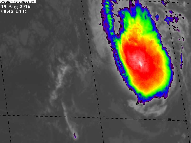
After a brief convective hiatus, deep convection with cloud tops of
-70C to -75C has redeveloped into a small CDO feature directly
over the previously exposed low-level circulation center. Satellite
classifications are T3.0/45 kt and T2.5/35 kt from TAFB and SAB,
respectively, and UW-CIMSS ADT values have decreased to T3.0/45 kt.
A blend of these values support an initial intensity of 40 kt.

Fiona is moving a little faster toward the northwest, or 300/09 kt.
Other than minor fluctuations in the forward speed of the cyclone
due to intermittent periods of convective re-organization like the
most recent episode, the latest model guidance continues to be in
strong agreement on Fiona moving west-northwestward to northwestward
toward a break in the Bermuda-Azores High for the next 120 hours.
Given the tightly packed model guidance about the previous few
forecast tracks, the new NHC track forecast is just an extension of
the previous advisory, and lies close to but a little slower than
the consensus model, TVCN.

There is no significant change to the previous intensity forecast or
rationale. Despite the earlier sharp decrease in deep convection,
the inner-core wind field of the compact cyclone has remained quite
robust based on the lack of no arc cloud lines or outflow boundaries
seen emanating outward from the center in visible satellite today.
As result, Fiona should be able to generate additional convection in
the short term and strengthen some during the next 12-24 hours.
After that time, the global and regional models remain in good
agreement on the cyclone moving through a band of strong
southwesterly vertical wind shear of 20-25 kt from 36-72 hours,
which is expected to induce weakening. However, the amount of
weakening remains uncertain due to continued mixed dynamic and
thermodynamic conditions. Although Fiona will be propagating through
significant shear and into a drier airmass, the small cyclone will
also be moving over warmer SSTs of 28C-29C and into a region of much
cooler upper-tropospheric temperatures, which will produce greater
instability and generate fairly strong convection that could help
offset the unfavorable shear conditions. Given these mixed signals,
the official intensity forecast remains an average of the various
intensity models, which at 72 hours still ranges from hurricane
strength in the GFDL model to a 25-kt remnant low in the ECMWF and
Navy-CTCI models.

FORECAST POSITIONS AND MAX WINDS

INIT 18/2100Z 17.0N 41.3W 40 KT 45 MPH
12H 19/0600Z 17.7N 42.5W 45 KT 50 MPH
24H 19/1800Z 18.5N 44.3W 45 KT 50 MPH
36H 20/0600Z 19.6N 46.1W 35 KT 40 MPH
48H 20/1800Z 20.8N 48.0W 35 KT 40 MPH
72H 21/1800Z 23.0N 51.7W 35 KT 40 MPH
96H 22/1800Z 25.0N 55.0W 35 KT 40 MPH
120H 23/1800Z 27.2N 56.6W 35 KT 40 MPH

$$
Forecaster Stewart
0 likes   
Visit the Caribbean-Central America Weather Thread where you can find at first post web cams,radars
and observations from Caribbean basin members Click Here

User avatar
Kazmit
Category 5
Category 5
Posts: 1915
Age: 21
Joined: Mon Jul 25, 2016 8:49 am
Location: Williamsburg VA for college, Bermuda otherwise

Re: ATL: FIONA - Tropical Storm - Discussion

#367 Postby Kazmit » Thu Aug 18, 2016 3:59 pm

NHC says another burst of convection is in the near future, and she should strengthen to 50mph before weakening for the final time.
0 likes   
Igor 2010, Sandy 2012, Fay 2014, Gonzalo 2014, Joaquin 2015, Nicole 2016, Humberto 2019

I am only a tropical weather enthusiast. My predictions are not official and may or may not be backed by sound meteorological data. For official information, please refer to the NHC and NWS products.

User avatar
wxman57
Moderator-Pro Met
Moderator-Pro Met
Posts: 22482
Age: 66
Joined: Sat Jun 21, 2003 8:06 pm
Location: Houston, TX (southwest)

Re: ATL: FIONA - Tropical Storm - Discussion

#368 Postby wxman57 » Thu Aug 18, 2016 4:14 pm

I doubt that Fiona will have 35kt winds beyond about 48 hours. I think the NHC is being quite generous in keeping Fiona a TS beyond 2-3 days. Anyway, it doesn't appear to be a threat to anyone.
0 likes   

User avatar
MetroMike
Category 3
Category 3
Posts: 826
Joined: Sun Aug 29, 2004 8:13 pm
Location: Tampa Bay
Contact:

Re: ATL: FIONA - Models

#369 Postby MetroMike » Thu Aug 18, 2016 4:15 pm

I would not write off the CMC solution as it has a good track record this season of picking up on patterns. Like the parade of cyclones earlier on in the W Pac.
0 likes   

User avatar
Kazmit
Category 5
Category 5
Posts: 1915
Age: 21
Joined: Mon Jul 25, 2016 8:49 am
Location: Williamsburg VA for college, Bermuda otherwise

Re: ATL: FIONA - Models

#370 Postby Kazmit » Thu Aug 18, 2016 4:20 pm

Models are starting to show a recurve well east of Bermuda- that is, if it lasts that long.
0 likes   
Igor 2010, Sandy 2012, Fay 2014, Gonzalo 2014, Joaquin 2015, Nicole 2016, Humberto 2019

I am only a tropical weather enthusiast. My predictions are not official and may or may not be backed by sound meteorological data. For official information, please refer to the NHC and NWS products.

User avatar
Nimbus
Category 5
Category 5
Posts: 4928
Joined: Mon Jul 19, 2004 10:54 am

Re: ATL: FIONA - Tropical Storm - Discussion

#371 Postby Nimbus » Thu Aug 18, 2016 7:00 pm

This is the upper air pattern that was causing the shear from the southwest I was talking about earlier. Looks like it is starting to get pinched and lift out in the 30 frame loop, not sure what will be there in 48 hours.

Image

http://weather.msfc.nasa.gov/GOES/goeseasthurrwv.html
0 likes   

User avatar
NDG
S2K Supporter
S2K Supporter
Posts: 14933
Joined: Sun Jul 09, 2006 10:14 pm
Location: Orlando, FL

Re: ATL: FIONA - Tropical Storm - Discussion

#372 Postby NDG » Thu Aug 18, 2016 8:24 pm

I guess the SW shear from the TUTT to the west of it is helping it fire up some convection tonight.

Image
0 likes   

User avatar
gatorcane
S2K Supporter
S2K Supporter
Posts: 23499
Age: 46
Joined: Sun Mar 13, 2005 3:54 pm
Location: Boca Raton, FL

Re: ATL: FIONA - Tropical Storm - Discussion

#373 Postby gatorcane » Thu Aug 18, 2016 8:37 pm

It doesn't seem like Fiona is moving much lately looking at the floater loops
0 likes   

User avatar
cycloneye
Admin
Admin
Posts: 139078
Age: 67
Joined: Thu Oct 10, 2002 10:54 am
Location: San Juan, Puerto Rico

Re: ATL: FIONA - Advisories

#374 Postby cycloneye » Thu Aug 18, 2016 9:43 pm

BULLETIN
TROPICAL STORM FIONA ADVISORY NUMBER 9
NWS NATIONAL HURRICANE CENTER MIAMI FL AL062016
1100 PM AST THU AUG 18 2016

...FIONA MOVING MORE SLOWLY TOWARD THE NORTHWEST...


SUMMARY OF 1100 PM AST...0300 UTC...INFORMATION
-----------------------------------------------
LOCATION...17.1N 41.8W
ABOUT 1180 MI...1900 KM W OF THE CABO VERDE ISLANDS
MAXIMUM SUSTAINED WINDS...45 MPH...75 KM/H
PRESENT MOVEMENT...NW OR 305 DEGREES AT 8 MPH...13 KM/H
MINIMUM CENTRAL PRESSURE...1006 MB...29.71 INCHES


TROPICAL STORM FIONA DISCUSSION NUMBER 9
NWS NATIONAL HURRICANE CENTER MIAMI FL AL062016
1100 PM AST THU AUG 18 2016

A sizable burst of deep convection has been ongoing since late this
afternoon, and recent microwave imagery suggests that the low-level
center may be a little closer to the thunderstorm activity than it
was for most of the day. Still, Dvorak estimates are unchanged at
T3.0/45 kt from TAFB and T2.5/35 kt from SAB, and the initial
intensity remains 40 kt.

Fiona's window for any strengthening is narrowing. SHIPS guidance
is currently analyzing 10-15 kt of south-southwesterly shear, while
the UW-CIMSS analysis has the shear as high as 20-25 kt. Despite
the discrepancy, these values suggest the shear is already
increasing, and it is expected to increase further and become more
westerly during the next three days. Therefore, if the current
burst of convection continues, Fiona has a chance to strengthen
slightly during the next 12 hours and then gradually weaken through
days 3 and 4. The forecast trends in the intensity models suggest
that Fiona could weaken to a tropical depression, which is now
shown in the official forecast. Environmental conditions appear to
be a little less hostile by the end of the forecast period, and the
NHC forecast allows for the possibility that Fiona could
restrengthen after the shear lightens up. The GFDL continues to
be an outlier by intensifying Fiona more than the other models, and
the official intensity forecast is therefore near or just below the
intensity consensus for most of the forecast period.

Microwave fixes indicate that Fiona has been moving more slowly
toward the northwest, or 305/7 kt. The cyclone is moving toward a
break in the subtropical ridge located between 40W-55W, and an
amplifying deep-layer trough over the north Atlantic is expected to
maintain this break for the next several days. By continuing on a
northwestward heading, Fiona is expected to reach the axis of the
subtropical ridge and turn northward by day 5. The GFDL is still
well to the northeast of the rest of the track guidance since it
carries a much stronger system, but the other models are otherwise
in very good agreement. Therefore, no significant changes were
made to the NHC track forecast, which remains close to the TVCN
multi-model consensus.

FORECAST POSITIONS AND MAX WINDS

INIT 19/0300Z 17.1N 41.8W 40 KT 45 MPH
12H 19/1200Z 17.8N 43.1W 45 KT 50 MPH
24H 20/0000Z 18.7N 44.9W 40 KT 45 MPH
36H 20/1200Z 19.8N 46.9W 35 KT 40 MPH
48H 21/0000Z 20.9N 48.9W 35 KT 40 MPH
72H 22/0000Z 23.0N 53.2W 30 KT 35 MPH
96H 23/0000Z 25.0N 56.5W 30 KT 35 MPH
120H 24/0000Z 27.5N 57.0W 35 KT 40 MPH

$$
Forecaster Berg
0 likes   
Visit the Caribbean-Central America Weather Thread where you can find at first post web cams,radars
and observations from Caribbean basin members Click Here

User avatar
euro6208
Category 5
Category 5
Posts: 18547
Joined: Mon Mar 08, 2004 7:50 pm
Location: Guam

Re: ATL: FIONA - Tropical Storm - Discussion

#375 Postby euro6208 » Thu Aug 18, 2016 11:09 pm

I actually like the name Fiona...sound so sweet. :lol:
1 likes   
Remember, all of my post aren't official. For official warnings and discussions, Please refer to your local NWS products...

NWS for the Western Pacific

https://www.weather.gov/gum/

LarryWx
Category 5
Category 5
Posts: 5700
Joined: Sun Sep 07, 2003 2:04 pm
Location: GA

Re: ATL: FIONA - Models

#376 Postby LarryWx » Fri Aug 19, 2016 1:46 am

Kazmit_ wrote:Models are starting to show a recurve well east of Bermuda- that is, if it lasts that long.


Now the model consensus is no recurve and perhaps it just dissipating off of the conus east last. The 0Z Crazy Uncle? You don't want to know!
0 likes   
Personal Forecast Disclaimer:
The posts in this forum are NOT official forecasts and should not be used as such. They are just the opinion of the poster and may or may not be backed by sound meteorological data. They are NOT endorsed by any professional institution or storm2k.org. For official information, please refer to the NHC and NWS products.

User avatar
cycloneye
Admin
Admin
Posts: 139078
Age: 67
Joined: Thu Oct 10, 2002 10:54 am
Location: San Juan, Puerto Rico

Re: ATL: FIONA - Advisories

#377 Postby cycloneye » Fri Aug 19, 2016 4:44 am

BULLETIN
TROPICAL STORM FIONA ADVISORY NUMBER 10
NWS NATIONAL HURRICANE CENTER MIAMI FL AL062016
500 AM AST FRI AUG 19 2016

...FIONA MOVING FASTER TOWARD THE WEST-NORTHWEST...


SUMMARY OF 500 AM AST...0900 UTC...INFORMATION
----------------------------------------------
LOCATION...17.6N 42.7W
ABOUT 1240 MI...1995 KM W OF THE CABO VERDE ISLANDS
MAXIMUM SUSTAINED WINDS...45 MPH...75 KM/H
PRESENT MOVEMENT...WNW OR 300 DEGREES AT 10 MPH...17 KM/H
MINIMUM CENTRAL PRESSURE...1006 MB...29.71 INCHES


TROPICAL STORM FIONA DISCUSSION NUMBER 10
NWS NATIONAL HURRICANE CENTER MIAMI FL AL062016
500 AM AST FRI AUG 19 2016

Fiona hasn't really changed much overall in the past several hours
with an earlier burst of convection having dissipated and a new
burst taking its place. Microwave data suggest the center is near
or south of the main area of thunderstorms, which is a sign of
the ongoing southwesterly shear. The initial wind speed is kept at
40 kt for this advisory since the Dvorak estimates are the same as
the previous cycle. Little significant change is expected with
Fiona's intensity today due to gradually increasing shear. The
storm should weaken over the weekend as the shear further increases,
along with the likely entrainment of drier mid-level air. While the
environmental conditions might get less hostile at the end of the
period, it is uncertain how much will be left of Fiona at that time
to take advantage of that change, with some suggestion in the global
models that Fiona could decay to a remnant low by then. Thus,
the new NHC intensity forecast is a bit lower than the previous one,
near a model consensus than excludes the GFDL (which has looked
consistently too high).

A timely AMSR2 pass helped show that Fiona has sped up, and is now
moving 300/9. Fiona should move around the Atlantic subtropical
ridge for the next few days. The biggest change to the track
guidance is that all of the models have shifted a few degrees
westward at long range. This appears to be due to less of a trough
forecast over the central Atlantic and a weaker representation of
Fiona in the global models, both of which would cause the storm to
continue moving northwestward for a longer period of time. The new
NHC track forecast follows the trend of the models, but remains a
fair distance east of the model consensus at days 4 and 5 due to
continuity constraints. It would not be surprising if further
westward adjustments had to be made later today.


FORECAST POSITIONS AND MAX WINDS

INIT 19/0900Z 17.6N 42.7W 40 KT 45 MPH
12H 19/1800Z 18.2N 44.0W 40 KT 45 MPH
24H 20/0600Z 19.1N 46.0W 35 KT 40 MPH
36H 20/1800Z 20.2N 48.1W 35 KT 40 MPH
48H 21/0600Z 21.3N 50.3W 30 KT 35 MPH
72H 22/0600Z 23.5N 54.8W 30 KT 35 MPH
96H 23/0600Z 26.0N 57.5W 30 KT 35 MPH
120H 24/0600Z 28.0N 59.0W 30 KT 35 MPH

$$
Forecaster Blake
0 likes   
Visit the Caribbean-Central America Weather Thread where you can find at first post web cams,radars
and observations from Caribbean basin members Click Here

User avatar
Nimbus
Category 5
Category 5
Posts: 4928
Joined: Mon Jul 19, 2004 10:54 am

Re: ATL: FIONA - Tropical Storm - Discussion

#378 Postby Nimbus » Fri Aug 19, 2016 6:20 am

New weakness scooping down south of 30n near -60 that might finish shearing Fiona down to a remnant low. Doesn't look like Fiona made it far enough west to get under the ridging.
1 likes   

User avatar
cycloneye
Admin
Admin
Posts: 139078
Age: 67
Joined: Thu Oct 10, 2002 10:54 am
Location: San Juan, Puerto Rico

Re: ATL: FIONA - Advisories

#379 Postby cycloneye » Fri Aug 19, 2016 10:43 am

BULLETIN
TROPICAL STORM FIONA ADVISORY NUMBER 11
NWS NATIONAL HURRICANE CENTER MIAMI FL AL062016
1100 AM AST FRI AUG 19 2016

...FIONA CONTINUING WEST-NORTHWESTWARD...


SUMMARY OF 1100 AM AST...1500 UTC...INFORMATION
-----------------------------------------------
LOCATION...17.8N 43.5W
ABOUT 1295 MI...2080 KM W OF THE CABO VERDE ISLANDS
MAXIMUM SUSTAINED WINDS...45 MPH...75 KM/H
PRESENT MOVEMENT...WNW OR 295 DEGREES AT 10 MPH...17 KM/H
MINIMUM CENTRAL PRESSURE...1006 MB...29.71 INCHES


TROPICAL STORM FIONA DISCUSSION NUMBER 11
NWS NATIONAL HURRICANE CENTER MIAMI FL AL062016
1100 AM AST FRI AUG 19 2016

Fiona continues to produce bursts of convection, mainly near and
north of the center. The current burst has weakened during the
past few hours, leaving the low-level center partly exposed south
of the convective area. Various objective and subjective satellite
intensity estimates range from 35-50 kt, and based on these, the
initial intensity remains 40 kt.

The initial motion is 295/9. A low- to mid-level ridge north of the
cyclone is steering Fiona west-northwestward, and this motion
should continue with some increase in forward speed during the next
48-72 hours. After that time, a developing weakness in the ridge
is expected to cause Fiona to turn northwestward. The guidance has
shifted a little westward between 72-120 hours. Thus, that portion
of the track is also nudged westward, but it lies to the east of
the various consensus models.

A combination of a dry air mass, increasing vertical wind shear, and
convergent upper-level flow should cause Fiona to weaken for the
next 3-4 days. The intensity forecast follows the guidance
consensus in calling for the cyclone to weaken to a depression by 48
hours, and then remain at about a 30 kt intensity through the rest
of the forecast period. An alternative scenario is that the system
weakens more than currently forecast and decays to a remnant low
sometime before day 4. As noted in the previous discussion, the
environmental conditions might get less hostile by day 5. However,
it is uncertain how much of the cyclone might be left to take
advantage of these more favorable conditions.


FORECAST POSITIONS AND MAX WINDS

INIT 19/1500Z 17.8N 43.5W 40 KT 45 MPH
12H 20/0000Z 18.4N 44.9W 40 KT 45 MPH
24H 20/1200Z 19.3N 46.9W 35 KT 40 MPH
36H 21/0000Z 20.4N 49.1W 35 KT 40 MPH
48H 21/1200Z 21.6N 51.5W 30 KT 35 MPH
72H 22/1200Z 24.0N 56.0W 30 KT 35 MPH
96H 23/1200Z 26.0N 58.5W 30 KT 35 MPH
120H 24/1200Z 28.0N 60.0W 30 KT 35 MPH

$$
Forecaster Beven
0 likes   
Visit the Caribbean-Central America Weather Thread where you can find at first post web cams,radars
and observations from Caribbean basin members Click Here

User avatar
gatorcane
S2K Supporter
S2K Supporter
Posts: 23499
Age: 46
Joined: Sun Mar 13, 2005 3:54 pm
Location: Boca Raton, FL

Re: ATL: FIONA - Models

#380 Postby gatorcane » Fri Aug 19, 2016 2:19 pm

12Z ECMWF weaker but shows a west bend north of the islands now with Fiona. Still should keep a watch if this finds favorable conditions down the road.
1 likes   


Return to “2016”

Who is online

Users browsing this forum: No registered users and 123 guests