AL, 98, 2016081400, , BEST, 0, 104N, 162W, 20, 0, DB, 0, , 0, 0, 0, 0, 0, 0, 0, 0, 0, , 0, , 0, 0, GENESIS013, , 0, , 0, 0, 0, 0, genesis-num, 013,
AL, 98, 2016081406, , BEST, 0, 101N, 172W, 20, 0, DB, 0, , 0, 0, 0, 0, 0, 0, 0, 0, 0, , 0, , 0, 0, GENESIS013, , 0, , 0, 0, 0, 0, genesis-num, 013,
AL, 98, 2016081412, , BEST, 0, 99N, 183W, 20, 0, DB, 0, , 0, 0, 0, 0, 0, 0, 0, 0, 0, , 0, , 0, 0, GENESIS013, , 0, , 0, 0, 0, 0, genesis-num, 013,
AL, 98, 2016081418, , BEST, 0, 98N, 194W, 20, 0, DB, 0, , 0, 0, 0, 0, 0, 0, 0, 0, 0, , 0, , 0, 0, GENESIS013, , 0, , 0, 0, 0, 0, genesis-num, 013,
AL, 98, 2016081500, , BEST, 0, 97N, 204W, 20, 1009, DB, 34, NEQ, 0, 0, 0, 0, 1010, 120, 60, 0, 0, L, 0, , 0, 0, INVEST
Thread at Talking Tropics forum that was the topic for this area.
viewtopic.php?f=31&t=118140
ATL: FIONA - Post-Tropical - Discussion
Moderator: S2k Moderators
-
cycloneye

- Admin

- Posts: 139064
- Age: 67
- Joined: Thu Oct 10, 2002 10:54 am
- Location: San Juan, Puerto Rico
ATL: FIONA - Post-Tropical - Discussion
0 likes
Visit the Caribbean-Central America Weather Thread where you can find at first post web cams,radars
and observations from Caribbean basin members Click Here
and observations from Caribbean basin members Click Here

Re: ATL: INVEST 98L - Discussion
12z Euro showed not much problem with shear and dry air for the next 4-5 days.
Last edited by NDG on Sun Aug 14, 2016 7:58 pm, edited 1 time in total.
0 likes
-
Kingarabian

- S2K Supporter

- Posts: 15434
- Joined: Sat Aug 08, 2009 3:06 am
- Location: Honolulu, Hawaii
-
cycloneye
- Admin
- Posts: 139064
- Age: 67
- Joined: Thu Oct 10, 2002 10:54 am
- Location: San Juan, Puerto Rico
ATL: FIONA - Models
Model runs here.


1 likes
Visit the Caribbean-Central America Weather Thread where you can find at first post web cams,radars
and observations from Caribbean basin members Click Here
and observations from Caribbean basin members Click Here
-
gatorcane

- S2K Supporter
- Posts: 23499
- Age: 46
- Joined: Sun Mar 13, 2005 3:54 pm
- Location: Boca Raton, FL
Re: ATL: INVEST 98L - Discussion
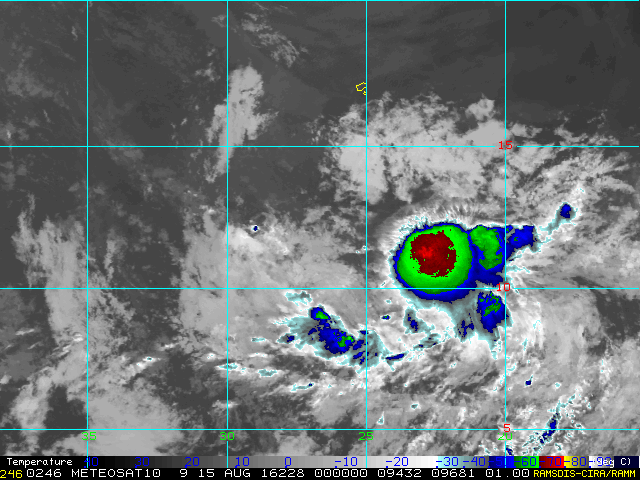
Convection is persisting unlike any wave we have seen come off Africa this season so far:
http://rammb.cira.colostate.edu/ramsdis ... display=12
http://rammb.cira.colostate.edu/ramsdis ... display=12
0 likes
-
wxman57

- Moderator-Pro Met

- Posts: 22480
- Age: 66
- Joined: Sat Jun 21, 2003 8:06 pm
- Location: Houston, TX (southwest)
Re: ATL: INVEST 98L - Discussion
Its best chance of development is over the next 3-4 days. Beyond then, wind shear increases along its path. It's particularly strong from the Gulf through the Caribbean this week.
0 likes
-
Kazmit

- Category 5

- Posts: 1915
- Age: 21
- Joined: Mon Jul 25, 2016 8:49 am
- Location: Williamsburg VA for college, Bermuda otherwise
Re: ATL: INVEST 98L - Models
SHIPs and TCLP show this becoming a Cat 1.
1 likes
Igor 2010, Sandy 2012, Fay 2014, Gonzalo 2014, Joaquin 2015, Nicole 2016, Humberto 2019
I am only a tropical weather enthusiast. My predictions are not official and may or may not be backed by sound meteorological data. For official information, please refer to the NHC and NWS products.
I am only a tropical weather enthusiast. My predictions are not official and may or may not be backed by sound meteorological data. For official information, please refer to the NHC and NWS products.
-
CrazyC83
- Professional-Met

- Posts: 33393
- Joined: Tue Mar 07, 2006 11:57 pm
- Location: Deep South, for the first time!
Re: ATL: INVEST 98L - Discussion
wxman57 wrote:Its best chance of development is over the next 3-4 days. Beyond then, wind shear increases along its path. It's particularly strong from the Gulf through the Caribbean this week.
I doubt it will get anywhere near those areas looking at early models - I think recurve before 50W is most likely.
2 likes
-
Blown Away

- S2K Supporter
- Posts: 9861
- Joined: Wed May 26, 2004 6:17 am
Re: ATL: INVEST 98L - Discussion
wxman57 wrote:Its best chance of development is over the next 3-4 days. Beyond then, wind shear increases along its path. It's particularly strong from the Gulf through the Caribbean this week.
What if 98L moves North of the Caribbean?
0 likes
Hurricane Eye Experience: David 79, Irene 99, Frances 04, Jeanne 04, Wilma 05...
Hurricane Brush Experience: Andrew 92, Erin 95, Floyd 99, Matthew 16, Irma 17, Ian 22, Nicole 22…
Hurricane Brush Experience: Andrew 92, Erin 95, Floyd 99, Matthew 16, Irma 17, Ian 22, Nicole 22…
-
OuterBanker
- S2K Supporter
- Posts: 1704
- Joined: Wed Feb 26, 2003 10:53 am
- Location: Nags Head, NC
- Contact:
Re: ATL: INVEST 98L - Discussion
This well developed, this far east and north the possible wife of Shrek is destined to be a fish anyway.
4 likes

-
hurricanes1234
- Category 5
- Posts: 2903
- Joined: Sat Jul 28, 2012 6:19 pm
- Location: Trinidad and Tobago
Re: ATL: INVEST 98L - Discussion
The wife of Shrek

That's exactly what I thought when I first saw the name Fiona on the list.
That's exactly what I thought when I first saw the name Fiona on the list.
1 likes
PLEASE NOTE: With the exception of information from weather agencies that I may copy and paste here, my posts will NEVER be official, since I am NOT a meteorologist. They are solely my amateur opinion, and may or may not be accurate. Therefore, please DO NOT use them as official details, particularly when making important decisions. Thank you.
Re: ATL: INVEST 98L - Discussion
Hard to say what the windshear forecast will be over the Caribbean after 5 days from now, but if an UL anticyclone accompanies 98L I am sure windshear will relax over the Caribbean just like it did for Earl, ULLs/TUTTs north of the Caribbean have been retrograding westward all season long, have not been permanent like last year.
That's even if 98L survives the central Atlantic and if it even tracks through the Caribbean.
That's even if 98L survives the central Atlantic and if it even tracks through the Caribbean.
0 likes
Re: ATL: INVEST 98L - Models
SHIPS shows not much problem with windshear, except for marginal warm enough waters by days 4-5 and drier conditions by then.
Code: Select all
* ATLANTIC     SHIPS INTENSITY FORECAST          *
                    * IR SAT DATA PROXY USED,      OHC AVAILABLE     *
                    *  INVEST      AL982016  08/15/16  00 UTC        *

TIME (HR)          0     6    12    18    24    36    48    60    72    84    96   108   120
V (KT) NO LAND    20    21    22    25    28    34    42    48    52    53    58    64    66
V (KT) LAND       20    21    22    25    28    34    42    48    52    53    58    64    66
V (KT) LGEM       20    20    21    21    22    24    26    30    34    37    39    42    44
Storm Type      TROP  TROP  TROP  TROP  TROP  TROP  TROP  TROP  TROP  TROP  TROP  TROP  TROP

SHEAR (KT)        13    18    15    15    13     8     7     9     8     7     4     7    13
SHEAR ADJ (KT)     5     2     2    -1     0     0    -3    -4    -4     1     1     2     0
SHEAR DIR         54    39    33    44    51    69    88   142   196   233   298   287   260
SST (C)         27.2  27.3  27.5  27.6  27.7  28.0  28.0  27.6  26.7  26.2  26.3  26.3  26.5
POT. INT. (KT)   127   129   131   132   133   137   137   132   121   116   117   118   120
ADJ. POT. INT.   127   130   133   132   132   137   135   128   117   111   112   113   115
200 MB T (C)   -53.7 -53.9 -53.8 -53.6 -53.8 -53.7 -53.8 -53.8 -53.7 -53.8 -53.8 -54.0 -53.9
200 MB VXT (C)  -0.2  -0.1  -0.1   0.1   0.0  -0.1  -0.1  -0.1   0.0   0.0   0.1   0.0   0.0
TH_E DEV (C)       5     6     6     6     6     6     5     5     5     5     5     5     6
700-500 MB RH     82    79    76    73    72    69    69    70    71    67    63    57    50
MODEL VTX (KT)     9     8     9    11    10     9     9     7     6     5     6     7  LOST
850 MB ENV VOR    81    82    85    85    83    72    67    62    58    49    52    54    52
200 MB DIV        42    22     7     5    18     4    15     8    26    32    35    35    13
700-850 TADV       0    -7   -10   -13   -15   -13    -8    -4    -3     0    -2     7     8
LAND (KM)        481   592   716   836   937  1123  1253  1388  1547  1782  2030  1934  1780
LAT (DEG N)      9.7   9.7   9.8   9.9  10.0  10.7  11.9  13.4  14.7  15.6  16.3  16.5  16.9
LONG(DEG W)     20.4  21.6  22.9  24.1  25.1  27.0  28.7  30.3  31.9  34.1  36.4  38.9  41.6
STM SPEED (KT)    11    12    12    11    10    11    10    10    11    12    12    13    13
HEAT CONTENT      13    11    11    18    19    11    12     9     6     4     5     3     6

  FORECAST TRACK FROM TABM      INITIAL HEADING/SPEED (DEG/KT):270/ 11      CX,CY: -10/  0
  T-12 MAX WIND:  20            PRESSURE OF STEERING LEVEL (MB):  598  (MEAN=618)
  GOES IR BRIGHTNESS TEMP. STD DEV.  50-200 KM RAD:  18.3 (MEAN=14.5)
  % GOES IR PIXELS WITH T < -20 C    50-200 KM RAD:  47.0 (MEAN=65.0)
  PRELIM RI PROB (DV .GE. 30 KT IN 24 HR):            4.1
0 likes
-
gatorcane
- S2K Supporter
- Posts: 23499
- Age: 46
- Joined: Sun Mar 13, 2005 3:54 pm
- Location: Boca Raton, FL
Re: ATL: INVEST 98L - Discussion
NDG I agree. It is too early to know the fate of 98l. The GFS and ECMWF differ by at least 700-800 miles as far as where 98l will be in a week's time. Not only that, the ECMWF as of the 00z Friday run just two days ago showed zero development of 98l due to hostile conditions now look what it is showing. That tells me the forecast is highly uncertain here a few days out let alone after a week's time. The question is even if 98l encounters the more hostile conditions, can it find better conditions further down the road?
Last edited by gatorcane on Sun Aug 14, 2016 9:22 pm, edited 1 time in total.
0 likes

-
cycloneye
- Admin
- Posts: 139064
- Age: 67
- Joined: Thu Oct 10, 2002 10:54 am
- Location: San Juan, Puerto Rico
Re: ATL: INVEST 98L - Discussion
gatorcane wrote:NDG I agree. It is too early to know the fate of 98l. The GFS and ECMWF differ by at least 700-800 miles as far as where 98l will be in a week's time. Not only that the ECMWF as of the 00z Friday run just two days ago showed zero development of 98l due to hostile conditions now look what it is showing. That should tell you the forecast is highly uncertain here. The question is even if 98l encounters the more hostile conditions, can it find better conditions further down the road?
Not saying it will be a cat 4-5 but an example of that was Andrew in 1992.
1 likes
Visit the Caribbean-Central America Weather Thread where you can find at first post web cams,radars
and observations from Caribbean basin members Click Here
and observations from Caribbean basin members Click Here

Re: ATL: INVEST 98L - Discussion
The structure is strung out even though you see the hot tower. It is a likely mess underneath. The popcorn thunderstorms ahead are not banding. It is still very low level driven.
0 likes
-
Yellow Evan

- Professional-Met
- Posts: 15951
- Age: 25
- Joined: Fri Jul 15, 2011 12:48 pm
- Location: Henderson, Nevada/Honolulu, HI
- Contact:
Re: ATL: INVEST 98L - Discussion
If this can get going soon (wind shear is moderate), this has a good chance at surviving the direr air since shear is low.
0 likes
Who is online
Users browsing this forum: No registered users and 119 guests