ATL: FIONA - Post-Tropical - Discussion
Moderator: S2k Moderators
-
Kazmit

- Category 5

- Posts: 1915
- Age: 21
- Joined: Mon Jul 25, 2016 8:49 am
- Location: Williamsburg VA for college, Bermuda otherwise
Re: ATL: FIONA - Tropical Storm - Discussion
Well, Fiona beat out Bonnie and Danielle for intensity, and looked a lot better than Colin. Plus, she fought off that dry air well. So she isn't a fail storm after all.
0 likes
Igor 2010, Sandy 2012, Fay 2014, Gonzalo 2014, Joaquin 2015, Nicole 2016, Humberto 2019
I am only a tropical weather enthusiast. My predictions are not official and may or may not be backed by sound meteorological data. For official information, please refer to the NHC and NWS products.
I am only a tropical weather enthusiast. My predictions are not official and may or may not be backed by sound meteorological data. For official information, please refer to the NHC and NWS products.
-
northjaxpro

- S2K Supporter

- Posts: 8900
- Joined: Mon Sep 27, 2010 11:21 am
- Location: Jacksonville, FL
Re: ATL: FIONA - Tropical Storm - Discussion
Well, now that Fiona has been stripped butt naked so to speak, I strongly disagree that this system currently is a tropical storm. As a.matter of fact, I will go as far saying that Taps is playing in the background, and. soon ask Wxman 57 to bring in Bones to make his official proclamation shortly.
1 likes
NEVER, EVER SAY NEVER in the tropics and weather in general, and most importantly, with life itself!!
________________________________________________________________________________________
Fay 2008 Beryl 2012 Debby 2012 Colin 2016 Hermine 2016 Julia 2016 Matthew 2016 Irma 2017 Dorian 2019
________________________________________________________________________________________
Fay 2008 Beryl 2012 Debby 2012 Colin 2016 Hermine 2016 Julia 2016 Matthew 2016 Irma 2017 Dorian 2019
Re: ATL: FIONA - Models
LarryWx wrote:That looks to me like a combo of the remnants of Fiona and 99L not moving much between FL & Bermuda on day 10 on the 0Z Euro
Somewhat similar to the 0Z Euro, the 6Z GFS looks like it has 99L absorb a good portion of Fiona's leftover vorticity while 99L is drifting WNW just NE of the Bahamas. At no time on these runs do I see Fiona's leftovers, themselves, recurve. Only after they are combined does the combo then eventually recurve on the 6Z GFS. Fascinating stuff that kind of reminds me of Fred of 2009 whose remnants actually made it all of the way to the SE coast though Fred never combined with another tropical entity.
I see that NDG also mentioned the 0Z Euro's interplay of the 2 systems.
0 likes
Personal Forecast Disclaimer:
The posts in this forum are NOT official forecasts and should not be used as such. They are just the opinion of the poster and may or may not be backed by sound meteorological data. They are NOT endorsed by any professional institution or storm2k.org. For official information, please refer to the NHC and NWS products.
The posts in this forum are NOT official forecasts and should not be used as such. They are just the opinion of the poster and may or may not be backed by sound meteorological data. They are NOT endorsed by any professional institution or storm2k.org. For official information, please refer to the NHC and NWS products.
-
cycloneye

- Admin

- Posts: 139025
- Age: 67
- Joined: Thu Oct 10, 2002 10:54 am
- Location: San Juan, Puerto Rico
Re: ATL: FIONA - Advisories
TROPICAL STORM FIONA DISCUSSION NUMBER 19
NWS NATIONAL HURRICANE CENTER MIAMI FL AL062016
1100 AM AST SUN AUG 21 2016
Strong westerly shear continues to take a toll on Fiona. After
becoming devoid of convection overnight, new convective cells have
developed around the small circulation, but there is not much
organization to the thunderstorm activity. Besides, the clouds tops
are already being sheared eastward by strong upper-level westerly
flow. Satellite intensity estimates are gradually decreasing, so
the initial wind speed has been lowered to 35 kt. Fiona will be
moving through a hostile environment consisting of strong westerly
shear and dry mid-level air during the next day or two. This
should result in some additional weakening, and Fiona is forecast
to become a tropical depression during the next 24 hours, and a
remnant low in a couple of days. If the small circulation can
survive the next 72 hours or so, environmental conditions could be
conducive for regeneration late in the forecast period. The GFS and
UKMET models maintain a weak low over the western Atlantic through
day 5, while the ECMWF depicts an open trough of low pressure by 72
hours. The NHC forecast maintains continuity with the previous
forecast, and shows dissipation around day 5.
Fiona is moving west-northwestward or 295/14 kt. A low- to
mid-level ridge over the central Atlantic should continue steering
the cyclone west-northwestward during the next couple of days.
Fiona will be nearing a break in the ridge over the western Atlantic
by mid-week which should cause a northwestward turn and reduction in
forward speed. The new NHC track forecast has been adjusted
slightly southward and is located between the latest multi-model
consensus and the previous NHC track prediction.
FORECAST POSITIONS AND MAX WINDS
INIT 21/1500Z 22.9N 53.3W 35 KT 40 MPH
12H 22/0000Z 23.6N 55.5W 35 KT 40 MPH
24H 22/1200Z 24.3N 58.1W 30 KT 35 MPH
36H 23/0000Z 25.0N 60.3W 30 KT 35 MPH
48H 23/1200Z 25.8N 62.2W 30 KT 35 MPH...POST-TROP/REMNT LOW
72H 24/1200Z 27.7N 65.5W 30 KT 35 MPH...POST-TROP/REMNT LOW
96H 25/1200Z 30.5N 67.0W 30 KT 35 MPH...POST-TROP/REMNT LOW
120H 26/1200Z...DISSIPATED
$$
Forecaster Brown
0 likes
Visit the Caribbean-Central America Weather Thread where you can find at first post web cams,radars
and observations from Caribbean basin members Click Here
and observations from Caribbean basin members Click Here

-
tolakram
- Admin
- Posts: 19165
- Age: 60
- Joined: Sun Aug 27, 2006 8:23 pm
- Location: Florence, KY (name is Mark)
Re: ATL: FIONA - Tropical Storm - Discussion
Fiona does not want to quit.
http://weather.msfc.nasa.gov/cgi-bin/get-goes?satellite=GOES-E%20HURRICANE&lat=24&lon=-55&info=vis&zoom=1&width=1024&height=725&type=Animation&quality=90&palette=ir1.pal&numframes=5&map=county&mapcolor=gray&map=none
http://weather.msfc.nasa.gov/cgi-bin/get-goes?satellite=GOES-E%20HURRICANE&lat=24&lon=-55&info=vis&zoom=1&width=1024&height=725&type=Animation&quality=90&palette=ir1.pal&numframes=5&map=county&mapcolor=gray&map=none
0 likes
M a r k
- - - - -
Join us in chat: Storm2K Chatroom Invite. Android and IOS apps also available.
The posts in this forum are NOT official forecasts and should not be used as such. Posts are NOT endorsed by any professional institution or STORM2K.org. For official information and forecasts, please refer to NHC and NWS products.

Re: ATL: FIONA - Tropical Storm - Discussion
NHC said the shear was going to remain intense for the next 24 hours but it looks like Fiona has had an easier time maintaining convection this afternoon.
0 likes
-
cycloneye
- Admin
- Posts: 139025
- Age: 67
- Joined: Thu Oct 10, 2002 10:54 am
- Location: San Juan, Puerto Rico
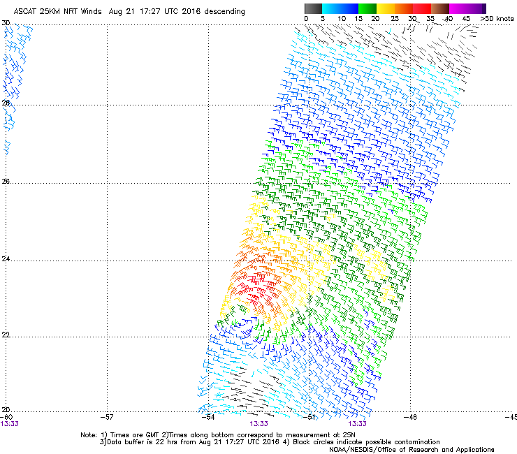
Re: ATL: FIONA - Advisories
TROPICAL STORM FIONA DISCUSSION NUMBER 20
NWS NATIONAL HURRICANE CENTER MIAMI FL AL062016
500 PM AST SUN AUG 21 2016
Deep convection continues to pulsate over the northern and eastern
portions of Fiona's circulation. However, there is very little
banding evident and the cloud tops are being advected quickly
eastward due to strong upper-level westerly winds over the cyclone.
This morning's ASCAT data that arrived just after the release of the
previous advisory indicated peak winds of 35 kt, which was in line
with the the earlier intensity estimate. Since there has been
little change in organization today, the initial wind speed will
remain 35 kt for this advisory. Strong westerly shear is forecast
to persist during the next day or so. This, combined with dry
mid-level air, should result in weakening, and Fiona is expected to
weaken to a tropical depression during the next 24 hours, and become
a remnant low in a couple of days. If Fiona or its remnants survive
the next few days, conditions could become somewhat conducive for
regeneration or restrengthening later in the forecast period. The
latest runs of GFS and UKMET models continue to maintain a weak low
through the 5-day forecast period, whereas the ECMWF shows
dissipation in 2 to 3 days. The NHC forecast continues to maintain
continuity, and indicates dissipation by day 5.
Fiona continues to move quickly west-northwestward to the south of a
low- to mid-level ridge over the central Atlantic. The cyclone will
be nearing the western portion of the ridge in a couple of days,
which is expected to cause Fiona to slow down. After 72 hours,
Fiona, or its remnants, should turn northwestward around the western
portion of the ridge. Due to model differences in the strength and
depth of Fiona after 48 hours, the spread in the track guidance is
quite large beyond 3 days. The updated NHC track is near the multi-
model consensus, which is closer to the GFS and GFS ensemble mean
solutions.
FORECAST POSITIONS AND MAX WINDS
INIT 21/2100Z 23.4N 54.9W 35 KT 40 MPH
12H 22/0600Z 23.9N 57.0W 35 KT 40 MPH
24H 22/1800Z 24.7N 59.5W 30 KT 35 MPH
36H 23/0600Z 25.4N 61.5W 30 KT 35 MPH
48H 23/1800Z 26.3N 63.3W 30 KT 35 MPH...POST-TROP/REMNT LOW
72H 24/1800Z 28.4N 66.3W 30 KT 35 MPH...POST-TROP/REMNT LOW
96H 25/1800Z 30.5N 67.0W 30 KT 35 MPH...POST-TROP/REMNT LOW
120H 26/1800Z...DISSIPATED
$$
Forecaster Brown
0 likes
Visit the Caribbean-Central America Weather Thread where you can find at first post web cams,radars
and observations from Caribbean basin members Click Here
and observations from Caribbean basin members Click Here
-
Kazmit
- Category 5
- Posts: 1915
- Age: 21
- Joined: Mon Jul 25, 2016 8:49 am
- Location: Williamsburg VA for college, Bermuda otherwise
Re: ATL: FIONA - Tropical Storm - Discussion
If Fiona can survive for the next 24hrs, it could get it's act together and restrengthen after it leaves the shear. She just doesn't wanna give up, so I'd say it's possible.
0 likes
Igor 2010, Sandy 2012, Fay 2014, Gonzalo 2014, Joaquin 2015, Nicole 2016, Humberto 2019
I am only a tropical weather enthusiast. My predictions are not official and may or may not be backed by sound meteorological data. For official information, please refer to the NHC and NWS products.
I am only a tropical weather enthusiast. My predictions are not official and may or may not be backed by sound meteorological data. For official information, please refer to the NHC and NWS products.
-
Emmett_Brown

- Category 5
- Posts: 1343
- Joined: Wed Aug 24, 2005 9:10 pm
- Location: Sarasota FL
Re: ATL: FIONA - Tropical Storm - Discussion
I'm interested to see how Fiona and 99L interact. 99l's envelope is pretty large.
0 likes

Re: ATL: FIONA - Tropical Storm - Discussion
northjaxpro wrote:Well, now that Fiona has been stripped butt naked so to speak, I strongly disagree that this system currently is a tropical storm. As a.matter of fact, I will go as far saying that Taps is playing in the background, and. soon ask Wxman 57 to bring in Bones to make his official proclamation shortly.
Totally agree looks no better than a remnant low.

0 likes
-
cycloneye
- Admin
- Posts: 139025
- Age: 67
- Joined: Thu Oct 10, 2002 10:54 am
- Location: San Juan, Puerto Rico
Re: ATL: FIONA - Advisories
TROPICAL DEPRESSION FIONA DISCUSSION NUMBER 21
NWS NATIONAL HURRICANE CENTER MIAMI FL AL062016
1100 PM AST SUN AUG 21 2016
Deep convection continues to sputter near the center of Fiona, with
each successive burst a little smaller and less organized than the
previous ones that sheared off in the strong westerly upper-level
winds. Given that earlier ASCAT data only showed a few 35-kt winds
and the decrease in convective organization since that time, the
initial intensity is set to 30 kt, which is also in agreement with
the latest TAFB Dvorak estimate.
The intensity forecast remains tricky. Fiona has been slowly
weakening due to about 30 kt of westerly wind shear and mid-level
dry air, and the NHC forecast shows the cyclone becoming a remnant
low in the next 24 to 36 hours. However, the shear is forecast to
decrease to 10 kt or less by 48 hours and the mid-levels begin to
moisten according to the SHIPS model forecast. Therefore, if Fiona
can survive the next 24 to 36 hours, the environment will become
more conducive for restrengthening or maintaining the system as a
tropical cyclone. The global models still disagree on the fate of
Fiona, with the ECMWF showing dissipation in 2-3 days while the GFS
and UKMET keep Fiona as a weak low through 5 days. The NHC forecast
maintains continuity and indicates dissipation in 5 days as a
compromise between these possibilities.
The initial motion estimate is 290/16, as Fiona continues to move
quickly west-northwestward under the influence of a low- to mid-
level ridge over the central Atlantic. Fiona, or its remnants, will
move around the western side of the ridge during the next several
days, which should result is a poleward turn and a decrease in
forward speed. The new NHC forecast is largely an update of the
previous one through dissipation. There continues to be a fair
amount of cross-track spread late in the period, and the NHC track
still favors the GFS solution and lies to the right of the multi-
model consensus.
FORECAST POSITIONS AND MAX WINDS
INIT 22/0300Z 23.8N 56.6W 30 KT 35 MPH
12H 22/1200Z 24.5N 58.6W 30 KT 35 MPH
24H 23/0000Z 25.3N 60.9W 30 KT 35 MPH
36H 23/1200Z 26.2N 62.8W 30 KT 35 MPH...POST-TROP/REMNT LOW
48H 24/0000Z 27.0N 64.5W 30 KT 35 MPH...POST-TROP/REMNT LOW
72H 25/0000Z 29.0N 67.0W 30 KT 35 MPH...POST-TROP/REMNT LOW
96H 26/0000Z 30.5N 68.0W 30 KT 35 MPH...POST-TROP/REMNT LOW
120H 27/0000Z...DISSIPATED
$$
Forecaster Brennan
0 likes
Visit the Caribbean-Central America Weather Thread where you can find at first post web cams,radars
and observations from Caribbean basin members Click Here
and observations from Caribbean basin members Click Here
-
cycloneye
- Admin
- Posts: 139025
- Age: 67
- Joined: Thu Oct 10, 2002 10:54 am
- Location: San Juan, Puerto Rico
Re: ATL: FIONA - Tropical Depression - Discussion
...FIONA WEAKENS TO A TROPICAL DEPRESSION...
SUMMARY OF 1100 PM AST...0300 UTC...INFORMATION
-----------------------------------------------
LOCATION...23.8N 56.6W
ABOUT 570 MI...915 KM NE OF THE NORTHERN LEEWARD ISLANDS
ABOUT 770 MI...1240 KM SE OF BERMUDA
MAXIMUM SUSTAINED WINDS...35 MPH...55 KM/H
PRESENT MOVEMENT...WNW OR 290 DEGREES AT 18 MPH...30 KM/H
MINIMUM CENTRAL PRESSURE...1008 MB...29.77 INCHES
0 likes
Visit the Caribbean-Central America Weather Thread where you can find at first post web cams,radars
and observations from Caribbean basin members Click Here
and observations from Caribbean basin members Click Here
-
cycloneye
- Admin
- Posts: 139025
- Age: 67
- Joined: Thu Oct 10, 2002 10:54 am
- Location: San Juan, Puerto Rico
Re: ATL: FIONA - Advisories
TROPICAL DEPRESSION FIONA DISCUSSION NUMBER 22
NWS NATIONAL HURRICANE CENTER MIAMI FL AL062016
500 AM AST MON AUG 22 2016
Although deep convection has continued to pulse near the center of
Fiona, recent scatterometer wind data and various satellite
classifications support maintaining the small but remarkably
resilient cyclone as a 30-kt tropical depression. The intensity
forecast still remains something of an enigma. Strong westerly wind
shear is forecast to persist for the next 12-18 hours, after which
the upper-level winds relax somewhat and become a little more
conducive for strengthening to occur. However, dry mid-level
air of 40-50 percent humidity is also forecast to surround the
cyclone, which could act to hinder the development of persistent
deep convection for the next 24-36 hours. Therefore, if Fiona
can survive the aforementioned hostile conditions during the next 24
hours or so, then some restrengthening or maintaining the status as
a tropical cyclone is possible. The global models still disagree on
the future of Fiona and have flipped-flopped, with the ECMWF no
longer showing dissipation in 5 days, which is similar to the UKMET
solution, whereas the GFS now shows Fiona degenerating into an open
trough between 96-120 hours. The NHC forecast maintains continuity
and indicates dissipation in 5 days as a compromise between these
possibilities.
The initial motion estimate remains 290/16 kt. Although there is
uncertainty in the future status of Fiona, the NHC model guidance
is in pretty good agreement on the track of the cyclone for the
next 72 hours. The small cyclone is forecast to move quickly
west-northwestward around the southwestern periphery of a
deep-layer ridge for the next 3 days, and then slow down
considerably on day 4 and turn northward into a weakness in the
ridge. The new official forecast track is basically just an update
of the previous track through 72 hours, and then is a little to
the right of the previous forecast on day 4, which leans closer to
the solutions of the various consensus models.
FORECAST POSITIONS AND MAX WINDS
INIT 22/0900Z 24.4N 58.4W 30 KT 35 MPH
12H 22/1800Z 25.0N 60.2W 30 KT 35 MPH
24H 23/0600Z 25.8N 62.3W 30 KT 35 MPH
36H 23/1800Z 26.6N 64.1W 30 KT 35 MPH...POST-TROP/REMNT LOW
48H 24/0600Z 27.6N 65.6W 30 KT 35 MPH...POST-TROP/REMNT LOW
72H 25/0600Z 29.8N 67.7W 30 KT 35 MPH...POST-TROP/REMNT LOW
96H 26/0600Z 31.3N 67.7W 30 KT 35 MPH...POST-TROP/REMNT LOW
120H 27/0600Z...DISSIPATED
$$
Forecaster Stewart
0 likes
Visit the Caribbean-Central America Weather Thread where you can find at first post web cams,radars
and observations from Caribbean basin members Click Here
and observations from Caribbean basin members Click Here
-
USTropics
- Category 5
- Posts: 2406
- Joined: Sun Aug 12, 2007 3:45 am
- Location: Florida State University
Re: ATL: FIONA - Tropical Depression - Discussion
Fiona really struggling this morning, the LLC is about to be exposed once again, with the cloud tops just being sheared right off:

0 likes
Re: ATL: FIONA - Tropical Depression - Discussion
About 2 days before it hits S FL with 99L, the 6Z GFS takes the remnants of Fiona to Cape Canaveral early on Sunday 8/28, which would be a similar WNW track to what Fred and its remnants of 2009 did for its entire track from way back in the E Atlantic:
Fiona of 2016: http://weather.unisys.com/hurricane/atl ... /track.gif
Fred of 2009: http://weather.unisys.com/hurricane/atl ... /track.gif
Fiona of 2016: http://weather.unisys.com/hurricane/atl ... /track.gif
Fred of 2009: http://weather.unisys.com/hurricane/atl ... /track.gif
0 likes
Personal Forecast Disclaimer:
The posts in this forum are NOT official forecasts and should not be used as such. They are just the opinion of the poster and may or may not be backed by sound meteorological data. They are NOT endorsed by any professional institution or storm2k.org. For official information, please refer to the NHC and NWS products.
The posts in this forum are NOT official forecasts and should not be used as such. They are just the opinion of the poster and may or may not be backed by sound meteorological data. They are NOT endorsed by any professional institution or storm2k.org. For official information, please refer to the NHC and NWS products.
-
cycloneye
- Admin
- Posts: 139025
- Age: 67
- Joined: Thu Oct 10, 2002 10:54 am
- Location: San Juan, Puerto Rico
Re: ATL: FIONA - Advisories
TROPICAL DEPRESSION FIONA DISCUSSION NUMBER 23
NWS NATIONAL HURRICANE CENTER MIAMI FL AL062016
1100 AM AST MON AUG 22 2016
The satellite depiction of Fiona currently features an exposed
low-level circulation with a few small areas of convection
southeast of the center. Subjective satellite intensity estimates
from TAFB and SAB are 30 kt, while the various objective estimates
range from 25-45 kt. The initial intensity remains 30 kt based
mainly on the subjective estimates.
The dynamical models forecast that the current westerly vertical
shear will subside somewhat by 48 hours as Fiona moves under an
upper-level trough into an area of easterly upper-level winds to
the north of the trough. By 72 hours, the models forecast the
cyclone or its remnants to encounter a second trough, which should
produce another round of strong southwesterly shear. Based on the
premise that the cyclone will not be able to respond to the brief
period of more favorable conditions, the new intensity forecast
calls for Fiona to gradually decay and become a remnant low in about
36 hours. This would be followed by the system weakening to a trough
after 96 hours.
The initial motion is 285/16. The guidance remains in good
agreement on the forecast track through 72 hours, with Fiona moving
west-northwestward to northwestward toward a developing break in
the subtropical ridge. Beyond that time, the guidance diverges,
with the ECMWF turning the remnants of the system northeastward
while the GFS and UKMET show a westward turn. The new forecast
track will compromise between these extremes in showing a slow
north-northwestward motion. The new forecast track is shifted a
little to the west of the previous track and lies near the various
consensus models.
FORECAST POSITIONS AND MAX WINDS
INIT 22/1500Z 24.6N 59.7W 30 KT 35 MPH
12H 23/0000Z 25.3N 61.5W 30 KT 35 MPH
24H 23/1200Z 26.1N 63.5W 30 KT 35 MPH
36H 24/0000Z 27.0N 65.2W 30 KT 35 MPH...POST-TROP/REMNT LOW
48H 24/1200Z 28.1N 66.5W 25 KT 30 MPH...POST-TROP/REMNT LOW
72H 25/1200Z 30.0N 68.0W 25 KT 30 MPH...POST-TROP/REMNT LOW
96H 26/1200Z 31.5N 68.5W 25 KT 30 MPH...POST-TROP/REMNT LOW
120H 27/1200Z...DISSIPATED
$$
Forecaster Beven
0 likes
Visit the Caribbean-Central America Weather Thread where you can find at first post web cams,radars
and observations from Caribbean basin members Click Here
and observations from Caribbean basin members Click Here
Re: ATL: FIONA - Tropical Depression - Discussion
LarryWx wrote:About 2 days before it hits S FL with 99L, the 6Z GFS takes the remnants of Fiona to Cape Canaveral early on Sunday 8/28, which would be a similar WNW track to what Fred and its remnants of 2009 did for its entire track from way back in the E Atlantic:
Fiona of 2016: http://weather.unisys.com/hurricane/atl ... /track.gif
Fred of 2009: http://weather.unisys.com/hurricane/atl ... /track.gif
The 12Z GFS also takes the Fiona remnant vorticity into Cape Canaveral but not til early on Mon 8/29, which is about 24 hours later than what the 6Z showed. Note that 99L is also not going across FL like the 6Z showed. Instead it is barely moving then and weaker in the Bahamas.
0 likes
Personal Forecast Disclaimer:
The posts in this forum are NOT official forecasts and should not be used as such. They are just the opinion of the poster and may or may not be backed by sound meteorological data. They are NOT endorsed by any professional institution or storm2k.org. For official information, please refer to the NHC and NWS products.
The posts in this forum are NOT official forecasts and should not be used as such. They are just the opinion of the poster and may or may not be backed by sound meteorological data. They are NOT endorsed by any professional institution or storm2k.org. For official information, please refer to the NHC and NWS products.
-
Weatherboy1

- Category 5
- Posts: 1167
- Age: 48
- Joined: Mon Jul 05, 2004 1:50 pm
- Location: Jupiter, FL
Re: ATL: FIONA - Tropical Depression - Discussion
Not saying it's going to happen, but it would be an interesting scenario to have a one-two punch of Fiona and 99 in FL. Certainly within the realm of possibility, even though it's not really LIKELY.
0 likes
-
Aric Dunn
- Category 5
- Posts: 21228
- Age: 41
- Joined: Sun Sep 19, 2004 9:58 pm
- Location: Ready for the Chase.
- Contact:
Re: ATL: FIONA - Tropical Depression - Discussion
on a side note.... Fiona is about to transition into a much lower shear environment over the next 12 hours. could make a little come back.
0 likes
Note: If I make a post that is brief. Please refer back to previous posts for the analysis or reasoning. I do not re-write/qoute what my initial post said each time.
If there is nothing before... then just ask
Space & Atmospheric Physicist, Embry-Riddle Aeronautical University,
I believe the sky is falling...
If there is nothing before... then just ask
Space & Atmospheric Physicist, Embry-Riddle Aeronautical University,
I believe the sky is falling...
Who is online
Users browsing this forum: No registered users and 17 guests