ATL: Ex INVEST 92L - Discussion
Moderator: S2k Moderators

Re: ATL: INVEST 92L - Discussion
I was waiting for 93L to go kaput before declaring to the Wife that we're probably in the clear for the year. FARK!!
0 likes
-
johngaltfla

- Category 5

- Posts: 1938
- Joined: Sun Jul 10, 2005 9:17 pm
- Location: Sarasota County, FL
- Contact:
Re: ATL: INVEST 92L - Discussion
I just got the oak tree off my house from Hermine. Not this again! 

1 likes
-
mcheer23

- Professional-Met

- Posts: 423
- Age: 30
- Joined: Sun Jun 24, 2012 8:24 pm
- Location: Sugar Land, Texas
Re: ATL: INVEST 92L - Discussion
johngaltfla wrote:I just got the oak tree off my house from Hermine. Not this again!
Steering currents are way different this time. MX/TX threat if it develops
1 likes

Re: ATL: INVEST 92L - Discussion
August 29th is a bad date remember the Memphis or was that the Tennessee?
1 likes
-
Nederlander
- S2K Supporter

- Posts: 1171
- Joined: Sat Jul 19, 2008 4:28 pm
- Location: Nederland, TX
Re: ATL: INVEST 92L - Discussion
johngaltfla wrote:I just got the oak tree off my house from Hermine. Not this again!
Looks like more of a western pusher.. I don't think FL will be under the gun on this one..
1 likes
-
Portastorm

- Storm2k Moderator

- Posts: 9787
- Age: 61
- Joined: Fri Jul 11, 2003 9:16 am
- Location: South Austin, TX
- Contact:
Re: ATL: INVEST 92L - Discussion
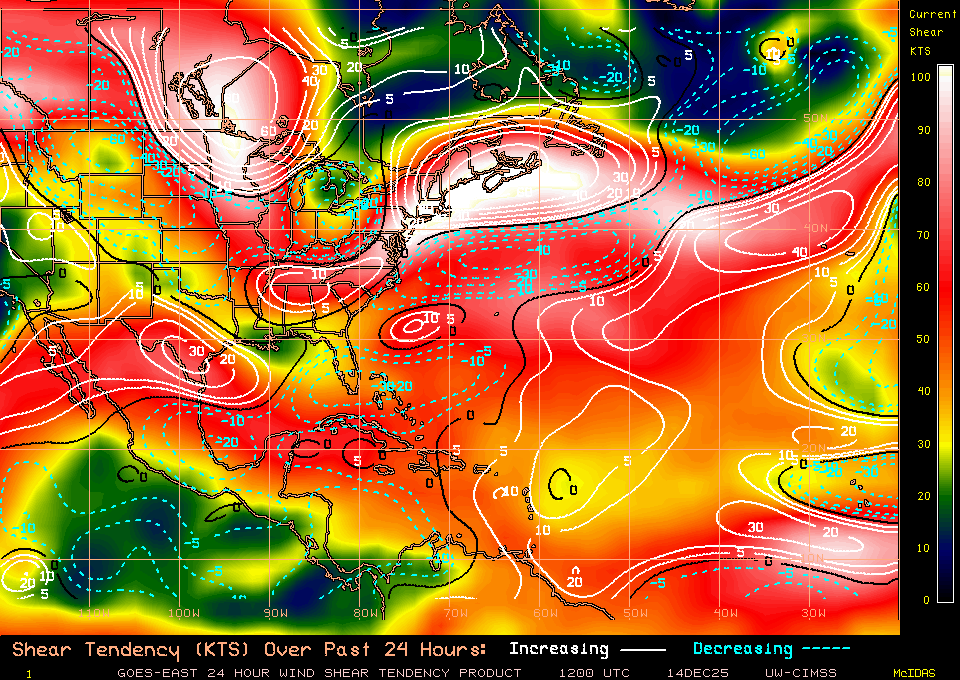
It's got my attention... the shear forecasts don't appear overwhelming, a developing anticyclone will be over the system by this weekend, an obvious stout low level circulation, and climatology all tells me this one is worth watching if you're along the central or western GOM.
0 likes
Any forecasts under my name are to be taken with a grain of salt. Get your best forecasts from the National Weather Service and National Hurricane Center.
I'm a certified Advanced SKYWARN-trained spotter and am active on Twitter at @TravisCOSW, a social media partner of the NWS Austin-San Antonio office.
I'm a certified Advanced SKYWARN-trained spotter and am active on Twitter at @TravisCOSW, a social media partner of the NWS Austin-San Antonio office.
Re: ATL: INVEST 92L - Discussion
likely going to Mexico or south Texas
And pay no attention to TWC. They are saying no closed low based upon model analyses. They not even bothering to look at satellite
And pay no attention to TWC. They are saying no closed low based upon model analyses. They not even bothering to look at satellite
2 likes
-
Kazmit

- Category 5
- Posts: 1915
- Age: 21
- Joined: Mon Jul 25, 2016 8:49 am
- Location: Williamsburg VA for college, Bermuda otherwise
Re: ATL: INVEST 92L - Discussion
I'd say it's a potential threat to south Texas. I wonder how much it'll be able to strengthen before landfall.
0 likes
Igor 2010, Sandy 2012, Fay 2014, Gonzalo 2014, Joaquin 2015, Nicole 2016, Humberto 2019
I am only a tropical weather enthusiast. My predictions are not official and may or may not be backed by sound meteorological data. For official information, please refer to the NHC and NWS products.
I am only a tropical weather enthusiast. My predictions are not official and may or may not be backed by sound meteorological data. For official information, please refer to the NHC and NWS products.
-
Aric Dunn
- Category 5
- Posts: 21228
- Age: 41
- Joined: Sun Sep 19, 2004 9:58 pm
- Location: Ready for the Chase.
- Contact:
Re: ATL: INVEST 92L - Discussion
shear dropping pretty quickly. another 8 to 12 hours and it will be moving into a better environment.
6 hours ago...
now

6 hours ago...
now
0 likes
Note: If I make a post that is brief. Please refer back to previous posts for the analysis or reasoning. I do not re-write/qoute what my initial post said each time.
If there is nothing before... then just ask
Space & Atmospheric Physicist, Embry-Riddle Aeronautical University,
I believe the sky is falling...
If there is nothing before... then just ask
Space & Atmospheric Physicist, Embry-Riddle Aeronautical University,
I believe the sky is falling...
-
Stormcenter
- S2K Supporter
- Posts: 6617
- Joined: Wed Sep 03, 2003 11:27 am
- Location: Houston, TX
Re: ATL: INVEST 92L - Discussion
Not sold on the south Texas or Mexico threat if this does develop.
0 likes
-
Tampa Bay Hurricane

- Category 5
- Posts: 5594
- Age: 36
- Joined: Fri Jul 22, 2005 7:54 pm
- Location: St. Petersburg, FL
Re: ATL: INVEST 92L - Discussion
Edited because my original post did not account for shear.
looks like it's headed for the western gulf. Shear should inhibit it for the next day or so, after that it may have a window to develop.
looks like it's headed for the western gulf. Shear should inhibit it for the next day or so, after that it may have a window to develop.
Last edited by Tampa Bay Hurricane on Fri Sep 09, 2016 3:11 pm, edited 2 times in total.
0 likes
Re: ATL: INVEST 92L - Discussion
Stormcenter wrote:Not sold on the south Texas or Mexico threat if this does develop.
big ridge is building
Also, as a general comment, look for this to get blasted by northerly shear during the next several hours
1 likes


Re: ATL: INVEST 92L - Discussion
Just goes to show you how fast things can change in the tropics. One moment it may look dead but bam! It throws a curveball. Not of all Atlantic looks favorable now, but you see how fast shear lessened around and over 92 and 93L.
0 likes
The posts or stuff said are NOT an official forecast. Please look to the NHC and NWS for official forecasts and products.
Floyd-1999, Frances-2004, Jeanne-2004, Fay-2008, Beryl-2012, Debby-2012, Colin-2016, Hermine-2016, Julia-2016, Matthew-2016, Irma-2017, Elsa-2021, Idalia-2023.
Go Gators! Go Jags!
Floyd-1999, Frances-2004, Jeanne-2004, Fay-2008, Beryl-2012, Debby-2012, Colin-2016, Hermine-2016, Julia-2016, Matthew-2016, Irma-2017, Elsa-2021, Idalia-2023.
Go Gators! Go Jags!
-
AJC3

- Admin

- Posts: 3869
- Age: 60
- Joined: Tue Aug 31, 2004 7:04 pm
- Location: West Melbourne, Florida
- Contact:
Re: ATL: INVEST 92L - Discussion
Aric Dunn wrote:shear dropping pretty quickly. another 8 to 12 hours and it will be moving into a better environment.
This improvement is likely to be a little slower to occur that that, since the strong upper trough NE of Florida still has a little more retrograding to do before it stalls out. All the global model guidance brings its axis from its current position near 75-76W to about 78W from 36-48 hours. This will bring the strong northerly winds on its backside a bit farther west across FL and into the Straits in tandem with the low for about another day and a half. But give it another day or two, so it can get out from underneath the 40-50kt of N-NW shear that it's currently getting blasted with, into the SE GOMEX (west of about 85W) in a few days where it's closer to being underneath that upper ridge and then we may be looking at a TC with better potential to intensify.
0 likes
-
Aric Dunn
- Category 5
- Posts: 21228
- Age: 41
- Joined: Sun Sep 19, 2004 9:58 pm
- Location: Ready for the Chase.
- Contact:
Re: ATL: INVEST 92L - Discussion
AJC3 wrote:Aric Dunn wrote:shear dropping pretty quickly. another 8 to 12 hours and it will be moving into a better environment.
This improvement is likely to be a little slower to occur that that, since the strong upper trough NE of Florida still has a little more retrograding to do before it stalls out. All the global model guidance brings its axis from its current position near 75-76W to about 78W from 36-48 hours. This will bring the strong northerly winds on its backside a bit farther west across FL and into the Straits in tandem with the low for about another day and a half. But give it another day or two, so it can get out from underneath the 40-50kt of N-NW shear that it's currently getting blasted with, into the SE GOMEX (west of about 85W) in a few days where it's closer to being underneath that upper ridge and then we may be looking at a TC with better potential to intensify.
fair enough. though the circ appears to be moving a little faster than the shear axis is whis is what I was noting just didn't elaborate. shear should slowly lesson as the naked circ moves west. agree though it wont be for another 36 hours or so till the winds drop off enough but at least in the next 12 hours it should move out of the 40kts its under now to around 20kts for the next day or two.
but we shall see.
0 likes
Note: If I make a post that is brief. Please refer back to previous posts for the analysis or reasoning. I do not re-write/qoute what my initial post said each time.
If there is nothing before... then just ask
Space & Atmospheric Physicist, Embry-Riddle Aeronautical University,
I believe the sky is falling...
If there is nothing before... then just ask
Space & Atmospheric Physicist, Embry-Riddle Aeronautical University,
I believe the sky is falling...

-
gatorcane

- S2K Supporter
- Posts: 23499
- Age: 46
- Joined: Sun Mar 13, 2005 3:54 pm
- Location: Boca Raton, FL
Re: ATL: INVEST 92L - Discussion
Shear looks quite strong at the moment - look how it just pushed the convection even further away from the naked swirl:

0 likes

Re: ATL: INVEST 92L - Discussion
This probably should've been upgraded earlier, but given that it just spit out the LLC (which is increasingly cloudless even at the lower level) it's looking unlikely. Still a bit of a surprise to see after a few days off from the active boards as there hasn't been much happening.
0 likes
The above post is not official and should not be used as such. It is the opinion of the poster and may or may not be backed by sound meteorological data. It is not endorsed by any professional institution or storm2k.org. For official information, please refer to the NHC and NWS products.
-
AJC3
- Admin
- Posts: 3869
- Age: 60
- Joined: Tue Aug 31, 2004 7:04 pm
- Location: West Melbourne, Florida
- Contact:
Re: ATL: INVEST 92L - Discussion
gatorcane wrote:Shear looks quite strong at the moment - look how it just pushed the convection even further away from the naked swirl:
If you look carefully at the top center of the last few images of that time lapse, what you can also see there is some transversely banded cirrus offshore the Florida east coast moving southward toward the LLC of 93L. This is associated with a belt of strong northerly winds on the backside of the upper trough that we've been talking about. The consensus of global model guidance brings northerly upper winds of about 25-30KT to the lower keys/straits tomorrow, before 93L moves into an area of more backed (W-NW) and weaker (~10KT) upper level winds on Sunday, This would still result in about 20KT of UL shear by then, given the westward motion of the Invest.
1 likes
-
AJC3
- Admin
- Posts: 3869
- Age: 60
- Joined: Tue Aug 31, 2004 7:04 pm
- Location: West Melbourne, Florida
- Contact:
Re: ATL: INVEST 92L - Discussion
Hammy wrote:This probably should've been upgraded earlier, but given that it just spit out the LLC (which is increasingly cloudless even at the lower level) it's looking unlikely. Still a bit of a surprise to see after a few days off from the active boards as there hasn't been much happening.
On the contrary, given what's taken place over the last 18 hours, this is precisely why you don't want to upgrade a system prematurely.
1 likes
Who is online
Users browsing this forum: No registered users and 33 guests