ATL: JULIA - Post-Tropical - Discussion

Moderator: S2k Moderators

Message
Author
floridasun78
Category 5
Category 5
Posts: 3755
Joined: Sun May 17, 2009 10:16 pm
Location: miami fl

Re: ATL; INVEST 93L - Discussion

#61 Postby floridasun78 » Thu Sep 08, 2016 5:44 pm

LarryWx wrote:
floridasun78 wrote:
jlauderdal wrote: what did craig setzr say?

he off tonight new guy on their he say nice weekend ahead :eek:


Florida,
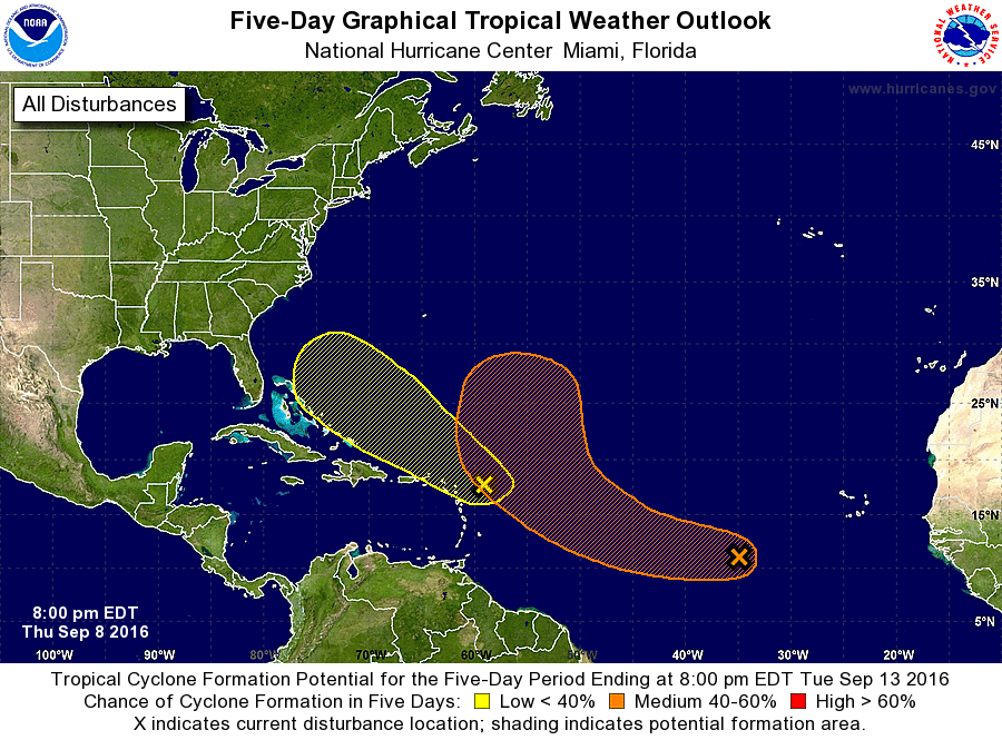
It isn't the weekend that's the question. It is around Tue-Thu of next week to see if 93L affects FL. But for now, you don't need to worry. Just follow it over the next few days and see if it even develops or what the models are showing. Also, yes, the GFDL/HWRF on that page aren't showing any output for some reason.

ty for update larry so we keep eye see what happen i be here follow with you other weather friends
0 likes   

floridasun78
Category 5
Category 5
Posts: 3755
Joined: Sun May 17, 2009 10:16 pm
Location: miami fl

Re: ATL; INVEST 93L - Discussion

#62 Postby floridasun78 » Thu Sep 08, 2016 6:14 pm

i having issue getting floater page to work any one having issue that page?
0 likes   

User avatar
Fishing
S2K Supporter
S2K Supporter
Posts: 67
Age: 64
Joined: Thu Sep 03, 2015 11:53 am
Location: Mount Pleasant, SC

Re: ATL; INVEST 93L - Discussion

#63 Postby Fishing » Thu Sep 08, 2016 6:18 pm

floridasun78 wrote:i having issue getting floater page to work any one having issue that page?

Not the one on the NHC site. I just glanced at it.
Fishing
1 likes   

User avatar
cycloneye
Admin
Admin
Posts: 139080
Age: 67
Joined: Thu Oct 10, 2002 10:54 am
Location: San Juan, Puerto Rico

Re: ATL; INVEST 93L - Discussion

#64 Postby cycloneye » Thu Sep 08, 2016 6:25 pm

A large area of cloudiness with showers and a few thunderstorms
located about 200 miles east of the northern Leeward Islands is
associated with a weak disturbance. Surface pressures remain high
in this area, and there are no signs of a surface circulation.
During the next few days, this system is expected to move west-
northwestward at 15 to 20 mph, and conditions are not expected to
be conducive for significant development.
* Formation chance through 48 hours...low...10 percent
* Formation chance through 5 days...low...20 percent
0 likes   
Visit the Caribbean-Central America Weather Thread where you can find at first post web cams,radars
and observations from Caribbean basin members Click Here

floridasun78
Category 5
Category 5
Posts: 3755
Joined: Sun May 17, 2009 10:16 pm
Location: miami fl

Re: ATL; INVEST 93L - Discussion

#65 Postby floridasun78 » Thu Sep 08, 2016 6:26 pm

cycloneye wrote:
A large area of cloudiness with showers and a few thunderstorms
located about 200 miles east of the northern Leeward Islands is
associated with a weak disturbance. Surface pressures remain high
in this area, and there are no signs of a surface circulation.
During the next few days, this system is expected to move west-
northwestward at 15 to 20 mph, and conditions are not expected to
be conducive for significant development.
* Formation chance through 48 hours...low...10 percent
* Formation chance through 5 days...low...20 percent

so nhc dont see any thing happen with 93l yet
0 likes   

AutoPenalti
Category 5
Category 5
Posts: 3949
Age: 27
Joined: Mon Aug 17, 2015 4:16 pm
Location: Ft. Lauderdale, Florida

Re: ATL; INVEST 93L - Discussion

#66 Postby AutoPenalti » Thu Sep 08, 2016 6:28 pm

Looks like shear is hitting it right now.
0 likes   
The posts in this forum are NOT official forecasts and should not be used as such. They are just the opinion of the poster and may or may not be backed by sound meteorological data. They are NOT endorsed by any professional institution or STORM2K. For official information, please refer to products from the NHC and NWS.


Model Runs Cheat Sheet:
GFS (5:30 AM/PM, 11:30 AM/PM)
HWRF, GFDL, UKMET, NAVGEM (6:30-8:00 AM/PM, 12:30-2:00 AM/PM)
ECMWF (1:45 AM/PM)

TCVN
is a weighted averaged

rockyman
Category 5
Category 5
Posts: 1967
Joined: Thu Jun 26, 2003 12:24 pm
Location: Dauphin Island, AL

Re: ATL; INVEST 93L - Discussion

#67 Postby rockyman » Thu Sep 08, 2016 6:28 pm

The 8pm TWO doesn't show a recurve like the 2pm:

Image
0 likes   

AutoPenalti
Category 5
Category 5
Posts: 3949
Age: 27
Joined: Mon Aug 17, 2015 4:16 pm
Location: Ft. Lauderdale, Florida

Re: ATL; INVEST 93L - Discussion

#68 Postby AutoPenalti » Thu Sep 08, 2016 6:44 pm

Image
0 likes   
The posts in this forum are NOT official forecasts and should not be used as such. They are just the opinion of the poster and may or may not be backed by sound meteorological data. They are NOT endorsed by any professional institution or STORM2K. For official information, please refer to products from the NHC and NWS.


Model Runs Cheat Sheet:
GFS (5:30 AM/PM, 11:30 AM/PM)
HWRF, GFDL, UKMET, NAVGEM (6:30-8:00 AM/PM, 12:30-2:00 AM/PM)
ECMWF (1:45 AM/PM)

TCVN
is a weighted averaged

User avatar
gatorcane
S2K Supporter
S2K Supporter
Posts: 23499
Age: 46
Joined: Sun Mar 13, 2005 3:54 pm
Location: Boca Raton, FL

Re: ATL; INVEST 93L - Discussion

#69 Postby gatorcane » Thu Sep 08, 2016 7:09 pm

convection on the increase near low-level vorticity

Image
0 likes   

User avatar
AJC3
Admin
Admin
Posts: 3873
Age: 60
Joined: Tue Aug 31, 2004 7:04 pm
Location: West Melbourne, Florida
Contact:

Re: ATL; INVEST 93L - Discussion

#70 Postby AJC3 » Thu Sep 08, 2016 7:11 pm

floridasun78 wrote:this getting alot weatherman in fl by surprise this was area was not even watch by nhc . but we here were we. beat nhc by watching this area


This is kind of an over the top comment to make. And certainly "surprise" is too strong of a word to use as far as Florida is concerned here, since 93L is (1) not a feature that's not terribly strong, and (2) not being forecast by the global models to amount to anything more than an inverted trough as it makes its CPA to the SE CONUS. It's also facetious to say NHC was not watching or monitoring it, just because it wasn't mentioned in the TWOs from 3 days ago. Remember that TAFB, which resides is in the very same room as the NHC, has been mentioning this in the TWD's since Monday morning, a little before the other thread on the low near 45W was started. So I think it's safe to assume that the NHC has been well aware of the system since its inception Monday. Finally, keep in mind the development prob is still only 20 percent over the next 5 days - so lets not get ahead of ourselves patting our collective selves on the back for having started a thread on a system before it was mentioned in a TWO, esepecially for an Invest that may never amount to a classifiable tropical system, let alone one that has significant (if any) impacts on Florida.
6 likes   

User avatar
Kazmit
Category 5
Category 5
Posts: 1915
Age: 21
Joined: Mon Jul 25, 2016 8:49 am
Location: Williamsburg VA for college, Bermuda otherwise

Re: ATL; INVEST 93L - Discussion

#71 Postby Kazmit » Thu Sep 08, 2016 7:15 pm

AutoPenalti wrote:Image

It looks like it might have to develop before hitting that wall of shear east of the Bahamas.
0 likes   
Igor 2010, Sandy 2012, Fay 2014, Gonzalo 2014, Joaquin 2015, Nicole 2016, Humberto 2019

I am only a tropical weather enthusiast. My predictions are not official and may or may not be backed by sound meteorological data. For official information, please refer to the NHC and NWS products.

LarryWx
Category 5
Category 5
Posts: 5700
Joined: Sun Sep 07, 2003 2:04 pm
Location: GA

Re: ATL; INVEST 93L - Discussion

#72 Postby LarryWx » Thu Sep 08, 2016 7:17 pm

gatorcane wrote:convection on the increase near low-level vorticity


Not only that, gator, but it appears to be moving more westbound than earlier though likely still north of west. IF this is a true reflection on the direction it will move over the next couple of days, that would, IF it were to develop, likely ultimately shut the door on an escape route from the SE CONUS due to it getting trapped below a stubborn ridge. Very slowly but steadily, the threat to the SE seems to be increasing for the Tue-Thu period of next week though the threat is still in the low category FOR NOW.
0 likes   
Personal Forecast Disclaimer:
The posts in this forum are NOT official forecasts and should not be used as such. They are just the opinion of the poster and may or may not be backed by sound meteorological data. They are NOT endorsed by any professional institution or storm2k.org. For official information, please refer to the NHC and NWS products.

User avatar
Kazmit
Category 5
Category 5
Posts: 1915
Age: 21
Joined: Mon Jul 25, 2016 8:49 am
Location: Williamsburg VA for college, Bermuda otherwise

Re: ATL; INVEST 93L - Discussion

#73 Postby Kazmit » Thu Sep 08, 2016 7:19 pm

rockyman wrote:The 8pm TWO doesn't show a recurve like the 2pm:

Image

Looks like they think it'll be trapped under a ridge, and not curve away from land. Not good for Florida, or SC/Georgia.
0 likes   
Igor 2010, Sandy 2012, Fay 2014, Gonzalo 2014, Joaquin 2015, Nicole 2016, Humberto 2019

I am only a tropical weather enthusiast. My predictions are not official and may or may not be backed by sound meteorological data. For official information, please refer to the NHC and NWS products.

User avatar
JaxGator
Category 2
Category 2
Posts: 754
Joined: Sun Jun 12, 2016 3:33 pm
Location: Jacksonville Florida

Re: ATL; INVEST 93L - Discussion

#74 Postby JaxGator » Thu Sep 08, 2016 9:46 pm

Ok.. I see we have 93L now and 4 pages, but NHC and Joe Bastardi have been talking about it for a day or so now, so I've had my eyes on it (and will be watching it more regardless of what comes of it). Still though, a little surprised.
0 likes   
The posts or stuff said are NOT an official forecast. Please look to the NHC and NWS for official forecasts and products.

Floyd-1999, Frances-2004, Jeanne-2004, Fay-2008, Beryl-2012, Debby-2012, Colin-2016, Hermine-2016, Julia-2016, Matthew-2016, Irma-2017, Elsa-2021, Idalia-2023.


Go Gators! Go Jags!

AutoPenalti
Category 5
Category 5
Posts: 3949
Age: 27
Joined: Mon Aug 17, 2015 4:16 pm
Location: Ft. Lauderdale, Florida

Re: ATL; INVEST 93L - Discussion

#75 Postby AutoPenalti » Thu Sep 08, 2016 10:23 pm

Kazmit_ wrote:
AutoPenalti wrote:Image

It looks like it might have to develop before hitting that wall of shear east of the Bahamas.

Shear forecasts change everyday. This picture was the shear as of 4 hours ago.
0 likes   
The posts in this forum are NOT official forecasts and should not be used as such. They are just the opinion of the poster and may or may not be backed by sound meteorological data. They are NOT endorsed by any professional institution or STORM2K. For official information, please refer to products from the NHC and NWS.


Model Runs Cheat Sheet:
GFS (5:30 AM/PM, 11:30 AM/PM)
HWRF, GFDL, UKMET, NAVGEM (6:30-8:00 AM/PM, 12:30-2:00 AM/PM)
ECMWF (1:45 AM/PM)

TCVN
is a weighted averaged

User avatar
northjaxpro
S2K Supporter
S2K Supporter
Posts: 8900
Joined: Mon Sep 27, 2010 11:21 am
Location: Jacksonville, FL

Re: ATL; INVEST 93L - Discussion

#76 Postby northjaxpro » Thu Sep 08, 2016 10:28 pm

We will have to watch closely especially over the weekend. We will have to see, provided if 93L can develop, if the system will get caught by a ridge building back in as a few models are showing within the next 5 days. The SE U.S. coast region and Florida possibly need to keep monitoring the progress of 93L the next few days.
0 likes   
NEVER, EVER SAY NEVER in the tropics and weather in general, and most importantly, with life itself!!

________________________________________________________________________________________

Fay 2008 Beryl 2012 Debby 2012 Colin 2016 Hermine 2016 Julia 2016 Matthew 2016 Irma 2017 Dorian 2019

AutoPenalti
Category 5
Category 5
Posts: 3949
Age: 27
Joined: Mon Aug 17, 2015 4:16 pm
Location: Ft. Lauderdale, Florida

Re: ATL; INVEST 93L - Discussion

#77 Postby AutoPenalti » Thu Sep 08, 2016 11:05 pm

I'm expecting this thread to starting hyping itself up by Saturday morning. 93L is devoid of convection right now and it doesn't even show some sort of LLC. Right now, it's currently in a favorable environment, shear is at 5kts from the SW and there's no dry air whatsoever. It's pretty interesting that it's not really developing at this time.
0 likes   
The posts in this forum are NOT official forecasts and should not be used as such. They are just the opinion of the poster and may or may not be backed by sound meteorological data. They are NOT endorsed by any professional institution or STORM2K. For official information, please refer to products from the NHC and NWS.


Model Runs Cheat Sheet:
GFS (5:30 AM/PM, 11:30 AM/PM)
HWRF, GFDL, UKMET, NAVGEM (6:30-8:00 AM/PM, 12:30-2:00 AM/PM)
ECMWF (1:45 AM/PM)

TCVN
is a weighted averaged

LarryWx
Category 5
Category 5
Posts: 5700
Joined: Sun Sep 07, 2003 2:04 pm
Location: GA

Re: ATL; INVEST 93L - Discussion

#78 Postby LarryWx » Thu Sep 08, 2016 11:25 pm

AutoPenalti wrote:I'm expecting this thread to starting hyping itself up by Saturday morning. 93L is devoid of convection right now and it doesn't even show some sort of LLC. Right now, it's currently in a favorable environment, shear is at 5kts from the SW and there's no dry air whatsoever. It's pretty interesting that it's not really developing at this time.


The unpredictability of the tropics never ceases to interest me. The tropics are quite humbling. I think that is the main reason for such great tropical forecasting discussions. If they were more predictable, how could that be as much fun to discuss?
0 likes   
Personal Forecast Disclaimer:
The posts in this forum are NOT official forecasts and should not be used as such. They are just the opinion of the poster and may or may not be backed by sound meteorological data. They are NOT endorsed by any professional institution or storm2k.org. For official information, please refer to the NHC and NWS products.

User avatar
northjaxpro
S2K Supporter
S2K Supporter
Posts: 8900
Joined: Mon Sep 27, 2010 11:21 am
Location: Jacksonville, FL

Re: ATL; INVEST 93L - Discussion

#79 Postby northjaxpro » Fri Sep 09, 2016 3:40 am

93L looks rather elongated here in the early wee hours of this Friday morning, although some convection is trying currently to pop up.The system has the look of an open wave axis for me at this time. It is difficult to see where there is any defined low level circulation at the moment with 93L.

However, there is a rather keen element of interest that has recaptured my attention. It is appears that.the remnant of ex-92L has re-flared back up in the past 12 hours or so just north is of Cuba. It is is sitting in extremely warm ssts in the FL Straits/Bahamas area. I am wondering somewhat if ex-92L may once again be a player in the overall synoptic scheme again?

Something else to watch the the next few days.
0 likes   
NEVER, EVER SAY NEVER in the tropics and weather in general, and most importantly, with life itself!!

________________________________________________________________________________________

Fay 2008 Beryl 2012 Debby 2012 Colin 2016 Hermine 2016 Julia 2016 Matthew 2016 Irma 2017 Dorian 2019

User avatar
abajan
S2K Supporter
S2K Supporter
Posts: 4175
Joined: Sun Sep 07, 2003 5:10 am
Location: Barbados

Re: ATL; INVEST 93L - Discussion

#80 Postby abajan » Fri Sep 09, 2016 5:45 am

5-Day Formation Chance Decreased to 10%

TROPICAL WEATHER OUTLOOK
NWS NATIONAL HURRICANE CENTER MIAMI FL
200 AM EDT FRI SEP 9 2016

For the North Atlantic...Caribbean Sea and the Gulf of Mexico:

... 2. An area of disorganized cloudiness and showers extending a couple
hundred miles east-northeast of the northern Leeward Islands is
associated with a weak disturbance. Surface pressures remain high
in this area, and there are no signs of a surface circulation.
During the next few days, this system is expected to move west-
northwestward at 15 to 20 mph, and conditions are not expected to be
conducive for significant development.
* Formation chance through 48 hours...low...10 percent
* Formation chance through 5 days...low...10 percent

Forecaster Brennan

Image
0 likes   


Return to “2016”

Who is online

Users browsing this forum: No registered users and 109 guests