EPAC: EUGENE - Post-Tropical
Moderator: S2k Moderators
-
TropicalAnalystwx13

- Category 5

- Posts: 2109
- Age: 26
- Joined: Tue Jul 19, 2011 8:20 pm
- Location: Wilmington, NC
- Contact:
Re: EPAC: EUGENE - Tropical Storm
Dry air is causing the system quite a bit of trouble this evening. The earlier RI has definitely leveled off, and it appears Eugene is holding steady at 65-70kt.
1 likes
-
Kingarabian

- S2K Supporter

- Posts: 15457
- Joined: Sat Aug 08, 2009 3:06 am
- Location: Honolulu, Hawaii
Re: EPAC: EUGENE - Tropical Storm
3 hours ago:

Recent infrared imagery show the western eyewall is now stronger than eastern side though.
Recent infrared imagery show the western eyewall is now stronger than eastern side though.
0 likes
RIP Kobe Bryant
-
hurricanes1234
- Category 5
- Posts: 2904
- Joined: Sat Jul 28, 2012 6:19 pm
- Location: Trinidad and Tobago
Re: EPAC: EUGENE - Tropical Storm
Unfortunately I'm starting to think this may not have enough time to strengthen beyond a Category 1.

0 likes
PLEASE NOTE: With the exception of information from weather agencies that I may copy and paste here, my posts will NEVER be official, since I am NOT a meteorologist. They are solely my amateur opinion, and may or may not be accurate. Therefore, please DO NOT use them as official details, particularly when making important decisions. Thank you.
-
Kingarabian
- S2K Supporter
- Posts: 15457
- Joined: Sat Aug 08, 2009 3:06 am
- Location: Honolulu, Hawaii
Re: EPAC: EUGENE - Tropical Storm
hurricanes1234 wrote:Unfortunately I'm starting to think this may not have enough time to strengthen beyond a Category 1.
It has 24 more hours. GFS doesn't peak it until 12 hours from now.
0 likes
RIP Kobe Bryant
-
Kingarabian
- S2K Supporter
- Posts: 15457
- Joined: Sat Aug 08, 2009 3:06 am
- Location: Honolulu, Hawaii
Re: EPAC: EUGENE - Tropical Storm
09/0000 UTC 14.1N 113.3W T4.5/4.5 EUGENE -- East Pacific
TXPZ28 KNES 090032
TCSENP
A. 05E (EUGENE)
B. 09/0000Z
C. 14.1N
D. 113.3W
E. ONE/GOES-W
F. T4.5/4.5/D2.5/24HRS
G. IR/EIR/VIS
H. REMARKS...MG EYE IS SURROUNDED BY LG AND EMBEDDED IN LG WHICH RESULTS
IN A DT=4.5 AFTER 0.5 IS SUBTRACTED FOR AN EYE ADJ. PT=4.0. MET=3.5
BASED ON RAPID DEVELOPMENT OVER THE LAST 24 HOURS. FT IS BASED ON DT.
I. ADDL POSITIONS
NIL
...SANDUSKY
Last edited by Kingarabian on Sat Jul 08, 2017 7:56 pm, edited 1 time in total.
0 likes
RIP Kobe Bryant
-
Kingarabian
- S2K Supporter
- Posts: 15457
- Joined: Sat Aug 08, 2009 3:06 am
- Location: Honolulu, Hawaii
Re: EPAC: EUGENE - Tropical Storm
Intensifying again. EUGENE YOU CAN DO IT KEEP GOING!

1 likes
RIP Kobe Bryant
-
Kingarabian
- S2K Supporter
- Posts: 15457
- Joined: Sat Aug 08, 2009 3:06 am
- Location: Honolulu, Hawaii


-
Yellow Evan

- Professional-Met

- Posts: 15959
- Age: 25
- Joined: Fri Jul 15, 2011 12:48 pm
- Location: Henderson, Nevada/Honolulu, HI
- Contact:
Re: EPAC: EUGENE - Tropical Storm
EP, 05, 2017070900, , BEST, 0, 141N, 1133W, 65, 991, HU, 64, NEQ, 20, 0, 0, 0, 1012, 180, 20, 0, 0, E, 0, , 0, 0, EUGENE, D, 0, , 0, 0, 0, 0, genesis-num, 008,
0 likes
-
Kingarabian
- S2K Supporter
- Posts: 15457
- Joined: Sat Aug 08, 2009 3:06 am
- Location: Honolulu, Hawaii
Re: EPAC: EUGENE - Tropical Storm
Yellow Evan wrote:EP, 05, 2017070900, , BEST, 0, 141N, 1133W, 65, 991, HU, 64, NEQ, 20, 0, 0, 0, 1012, 180, 20, 0, 0, E, 0, , 0, 0, EUGENE, D, 0, , 0, 0, 0, 0, genesis-num, 008,
Way too low considering its MW presentation. ADT is almost @ 4.5, which would be 75kts at least.
2 likes
RIP Kobe Bryant
-
hurricanes1234
- Category 5
- Posts: 2904
- Joined: Sat Jul 28, 2012 6:19 pm
- Location: Trinidad and Tobago
Re: EPAC: EUGENE - Tropical Storm
Personally I don't think they'll go with above 65 knots. If anything, maybe 70 but not 75.
Now I agree that it does have the look of a 75 knot system to my amateur eyes.
Now I agree that it does have the look of a 75 knot system to my amateur eyes.
0 likes
PLEASE NOTE: With the exception of information from weather agencies that I may copy and paste here, my posts will NEVER be official, since I am NOT a meteorologist. They are solely my amateur opinion, and may or may not be accurate. Therefore, please DO NOT use them as official details, particularly when making important decisions. Thank you.
-
SouthDadeFish

- Professional-Met
- Posts: 2835
- Joined: Thu Sep 23, 2010 2:54 pm
- Location: Miami, FL
- Contact:
Re: EPAC: EUGENE - Tropical Storm
I haven't seen anything to show the intensification trend has leveled off... The vigorous convective bursts in the eyewall are obscuring the eye on conventional geostationary satellite imagery. On microwave imagery you can see a clearly defined eyewall and eye. This TC has a legit shot of reaching major status, in my opinion.
5 likes
-
Yellow Evan
- Professional-Met
- Posts: 15959
- Age: 25
- Joined: Fri Jul 15, 2011 12:48 pm
- Location: Henderson, Nevada/Honolulu, HI
- Contact:
Re: EPAC: EUGENE - Tropical Storm
hurricanes1234 wrote:Personally I don't think they'll go with above 65 knots. If anything, maybe 70 but not 75.
Given SAB is at T4.5 along with ADT, that easily justifies 70.
0 likes
-
Kingarabian
- S2K Supporter
- Posts: 15457
- Joined: Sat Aug 08, 2009 3:06 am
- Location: Honolulu, Hawaii
Re: EPAC: EUGENE - Tropical Storm
ADT would be a lot higher if it could get the center right...
Last edited by Kingarabian on Sun Jul 09, 2017 12:13 am, edited 1 time in total.
1 likes
RIP Kobe Bryant
-
cycloneye

- Admin

- Posts: 139526
- Age: 67
- Joined: Thu Oct 10, 2002 10:54 am
- Location: San Juan, Puerto Rico
Re: EPAC: EUGENE - Hurricane
Forecast to be a cat 2.
Hurricane Eugene Discussion Number 6
NWS National Hurricane Center Miami FL EP052017
900 PM MDT Sat Jul 08 2017
Eugene has strengthened rapidly over the past 24 h and has reached
hurricane strength during the past few hours. Recent microwave
imagery indicates that a 25 n mi wide eye has formed, and this
feature has also appeared sporadically in visible and infrared
imagery. The initial intensity is raised to 70 kt based on various
satellite intensity estimates in the 65-75 kt range. The hurricane
continues to have good to excellent cirrus outflow in all directions
as it remains in an environment of light vertical wind shear.
Smoothing through the wobbles of the formative eye, the initial
motion is 320/7. The hurricane is moving toward a weakness in the
subtropical ridge to the west of the Baja California Peninsula, and
the track forecast guidance is in good agreement that a
northwestward motion should continue through the forecast period,
with some increase in forward speed during the first 24 h and some
decrease in forward speed after 72 h. The guidance has changed
little since the last advisory, and the new forecast track is
similar to the previous forecast.
Eugene should remain over warm water and in a light shear
environment for about the next 24 h. Thus, additional strengthening
is expected, with the main question being will the current rate of
intensification continue. The forecast peak intensity is increased
to 90 kt, which is above the intensity guidance but could be
conservative if the intensification rate does not decrease. After
24 hours, the cyclone should move over colder water, with the sea
surface temperature along the forecast track expected to be near
21C by 96 h. This should cause Eugene to steadily or rapidly weaken
after 24 h, with the system expected to decay to a remnant low by 96
h.
FORECAST POSITIONS AND MAX WINDS
INIT 09/0300Z 14.4N 113.5W 70 KT 80 MPH
12H 09/1200Z 15.4N 114.3W 80 KT 90 MPH
24H 10/0000Z 16.9N 115.6W 90 KT 105 MPH
36H 10/1200Z 18.7N 117.1W 80 KT 90 MPH
48H 11/0000Z 20.2N 118.4W 65 KT 75 MPH
72H 12/0000Z 22.5N 120.5W 40 KT 45 MPH
96H 13/0000Z 24.5N 122.5W 25 KT 30 MPH...POST-TROP/REMNT LOW
120H 14/0000Z 26.0N 124.5W 20 KT 25 MPH...POST-TROP/REMNT LOW
$$
Forecaster Beven
0 likes
Visit the Caribbean-Central America Weather Thread where you can find at first post web cams,radars
and observations from Caribbean basin members Click Here
and observations from Caribbean basin members Click Here
-
TropicalAnalystwx13
- Category 5
- Posts: 2109
- Age: 26
- Joined: Tue Jul 19, 2011 8:20 pm
- Location: Wilmington, NC
- Contact:
Re: EPAC: EUGENE - Hurricane
Agree with NHC's 70kt. Cloud pattern has become more symmetric over the past few hours, though it's obvious there's dry air lurking outside the CDO and across the eastern semicircle of the cyclone. If the convective blow-up in the western eyewall wraps around and isn't disrupted, there's no reason Eugene won't reach Cat 2 intensity tomorrow.
1 likes
-
Kingarabian
- S2K Supporter
- Posts: 15457
- Joined: Sat Aug 08, 2009 3:06 am
- Location: Honolulu, Hawaii
Re: EPAC: EUGENE - Hurricane
Could be a major hurricane by the next advisory. Only question is if Satellite intensity forecasts will keep up.
1 likes
RIP Kobe Bryant
-
Kingarabian
- S2K Supporter
- Posts: 15457
- Joined: Sat Aug 08, 2009 3:06 am
- Location: Honolulu, Hawaii
Re: EPAC: EUGENE - Tropical Storm
SouthDadeFish
is absolutely right.
The overshooting cloud tops are obscuring the eye. Thus, Dvorak estimates are thrown off. We've seen this happen in Atlantic systems in the past that have recon. Overshooting cloud tops clouding the eye yet the storm having stronger winds despite the filled eye presence on satellite.
Check this recent 30 minute old GMI pass. Look how intense the eyewall is in almost all the quads.

That's clearly a strong eyewall, and Eugene is close if not already a major hurricane. Typically with EPAC storms we see an eyewall develop followed by an eye clearing out shortly after. The eyewall is clearly evident here and the eye is defined in microwave but no so much on visible.
is absolutely right.
The overshooting cloud tops are obscuring the eye. Thus, Dvorak estimates are thrown off. We've seen this happen in Atlantic systems in the past that have recon. Overshooting cloud tops clouding the eye yet the storm having stronger winds despite the filled eye presence on satellite.
Check this recent 30 minute old GMI pass. Look how intense the eyewall is in almost all the quads.
That's clearly a strong eyewall, and Eugene is close if not already a major hurricane. Typically with EPAC storms we see an eyewall develop followed by an eye clearing out shortly after. The eyewall is clearly evident here and the eye is defined in microwave but no so much on visible.
3 likes
RIP Kobe Bryant
-
Yellow Evan
- Professional-Met
- Posts: 15959
- Age: 25
- Joined: Fri Jul 15, 2011 12:48 pm
- Location: Henderson, Nevada/Honolulu, HI
- Contact:
Re: EPAC: EUGENE - Hurricane
Kingarabian wrote:Could be a major hurricane by the next advisory. Only question is if Satellite intensity forecasts will keep up.
It's convection is gonna really need to wrap around, and I don't see a thick B or W ring developing and persisting, or the eye getting 10C+ in the next few hours. In 12-18 hours? Sure.
0 likes
-
Kingarabian
- S2K Supporter
- Posts: 15457
- Joined: Sat Aug 08, 2009 3:06 am
- Location: Honolulu, Hawaii
Re: EPAC: EUGENE - Hurricane
Yellow Evan wrote:Kingarabian wrote:Could be a major hurricane by the next advisory. Only question is if Satellite intensity forecasts will keep up.
It's convection is gonna really need to wrap around, and I don't see a thick B or W ring developing and persisting, or the eye getting 10C+ in the next few hours. In 12-18 hours? Sure.
Eyewall is intense and eye is defined enough to indicate at Cat3 per microwave. Compare that GMI pass with past hurricanes and you'll see the comparison.
2 likes
RIP Kobe Bryant
-
1900hurricane

- Category 5
- Posts: 6044
- Age: 33
- Joined: Fri Feb 06, 2015 12:04 pm
- Location: Houston, TX
- Contact:
Re: EPAC: EUGENE - Hurricane
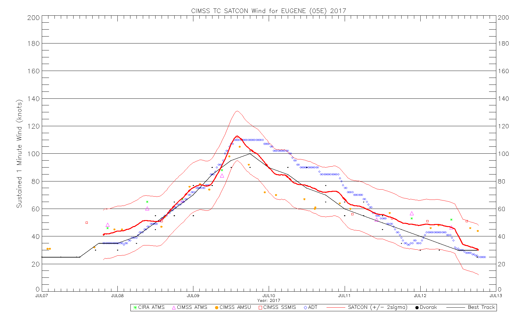
I'm not sure how much the NHC trusts SATCON, but every single one of its recent components are higher than the 00Z best track update (no SSMIS updates in a while though). As of now, the SATCON mean is at 78 kt.
1 likes
Contract Meteorologist. TAMU & MSST. Fiercely authentic, one of a kind. We are all given free will, so choose a life meant to be lived. We are the Masters of our own Stories.
Opinions expressed are mine alone.
Follow me on Twitter at @1900hurricane : Read blogs at https://1900hurricane.wordpress.com/
Opinions expressed are mine alone.
Follow me on Twitter at @1900hurricane : Read blogs at https://1900hurricane.wordpress.com/
Who is online
Users browsing this forum: No registered users and 4 guests