WPAC: NANMADOL - Post-Tropical
Moderator: S2k Moderators

Re: WPAC: INVEST 99W
EURO kinda drop this system and GFS still not too optimistic about it. Maybe a TD or weak TS at best.
0 likes
Remember, all of my post aren't official. For official warnings and discussions, Please refer to your local NWS products...
NWS for the Western Pacific
https://www.weather.gov/gum/
NWS for the Western Pacific
https://www.weather.gov/gum/
Re: WPAC: INVEST 99W


0 likes
Remember, all of my post aren't official. For official warnings and discussions, Please refer to your local NWS products...
NWS for the Western Pacific
https://www.weather.gov/gum/
NWS for the Western Pacific
https://www.weather.gov/gum/
-
doomhaMwx

- Category 5

- Posts: 2399
- Age: 25
- Joined: Tue Apr 18, 2017 4:01 am
- Location: Baguio/Benguet, Philippines
- Contact:
Re: WPAC: INVEST 99W
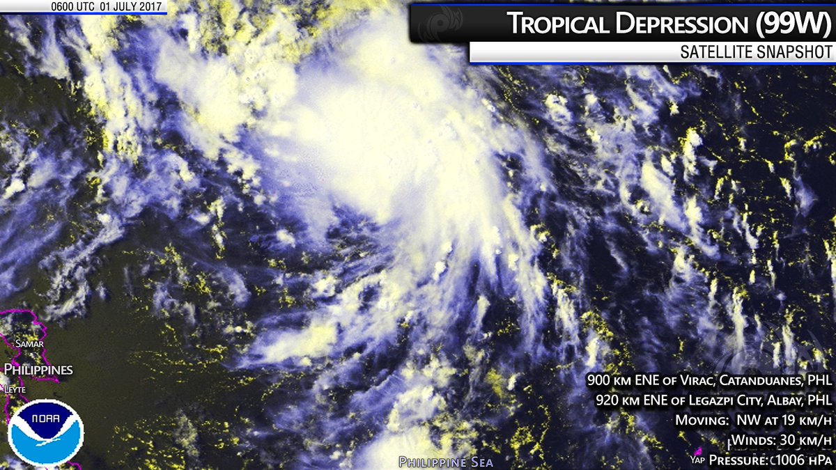
Now the subject of a TCFA by the JTWC...
REMARKS:
THE AREA OF CONVECTION (INVEST 99W) PREVIOUSLY LOCATED NEAR 11.2N 135.9E IS NOW LOCATED NEAR 14.3N 132.3E, APPROXIMATELY 755 NM SOUTHEAST OF ISHIGAKI-JIMA, JAPAN. ANIMATED MULTISPECTRAL SATELLITE IMAGERY DEPICTS A CONSOLIDATING LOW-LEVEL CIRCULATION CENTER (LLCC)WITH PERSISTENT CENTRAL CONVECTION AND FORMATIVE BANDING OVER THE EASTERN SEMI-CIRCLE. A 010056Z METOP-A 89GHZ IMAGE SHOWS DEEP CONVECTIVE BANDING ALONG THE EASTERN FLANK OF THE SYSTEM WITH SHALLOW BANDING ELSEWHERE WRAPPING INTO AN ELONGATED LLCC. A 010057Z PARTIAL ASCAT IMAGE INDICATED 15 TO 20 KNOT WINDS OVER THE EASTERN SEMI-CIRCLE. UPPER-LEVEL ANALYSIS REVEALS A VERY FAVORABLE ENVIRONMENT WITH GOOD POLEWARD OUTFLOW ENHANCED BY A TUTT CELL NEAR 17N 124E AND ENHANCED EQUATORWARD OUTFLOW ASSOCIATED WITH THE TUTT POSITIONED NEAR GUAM. ADDITIONALLY, SST VALUES ARE CONDUCIVE AT 30 TO 31C AND VERTICAL WIND SHEAR IS LOW TO MODERATE. GLOBAL MODELS INDICATE A QUICK NORTHWESTWARD TRACK AND ARE IN TIGHT AGREEMENT, HOWEVER, THE MODELS CONTINUE TO STRUGGLE WITH DEVELOPMENT.
MAXIMUM SUSTAINED SURFACE WINDS ARE ESTIMATED AT 20 TO 25 KNOTS. MINIMUM SEA LEVEL PRESSURE IS ESTIMATED TO BE NEAR 1006 MB. THE POTENTIAL FOR THE DEVELOPMENT OF A SIGNIFICANT TROPICAL CYCLONE WITHIN THE NEXT 24 HOURS IS HIGH.
0 likes
Re: WPAC: INVEST 99W
TPPN10 PGTW 010625
A. TROPICAL DISTURBANCE 99W (NW OF PALAU)
B. 01/0600Z
C. 15.91N
D. 131.13E
E. FIVE/HMWRI8
F. T1.0/1.0/W0.5/24HRS STT: S0.0/03HRS
G. IR/EIR/VIS/MSI
H. REMARKS: 40A/PBO SBC/ANMTN. .25 WRAP YIELDS A DT OF 1.0. PT
AND MET AGREE. DBO DT.
I. ADDITIONAL POSITIONS: NONE
MARTINEZ
A. TROPICAL DISTURBANCE 99W (NW OF PALAU)
B. 01/0600Z
C. 15.91N
D. 131.13E
E. FIVE/HMWRI8
F. T1.0/1.0/W0.5/24HRS STT: S0.0/03HRS
G. IR/EIR/VIS/MSI
H. REMARKS: 40A/PBO SBC/ANMTN. .25 WRAP YIELDS A DT OF 1.0. PT
AND MET AGREE. DBO DT.
I. ADDITIONAL POSITIONS: NONE
MARTINEZ
0 likes
Remember, all of my post aren't official. For official warnings and discussions, Please refer to your local NWS products...
NWS for the Western Pacific
https://www.weather.gov/gum/
NWS for the Western Pacific
https://www.weather.gov/gum/
-
senorpepr

- Military Met/Moderator

- Posts: 12542
- Age: 41
- Joined: Fri Aug 22, 2003 9:22 pm
- Location: Mackenbach, Germany
- Contact:
Re: WPAC: INVEST 99W
JMA is now calling 99W a tropical depression as well.
WWJP25 RJTD 010600
WARNING AND SUMMARY 010600.
WARNING VALID 020600.
WARNING IS UPDATED EVERY 6 HOURS.
WARNING.
DENSE FOG OBSERVED LOCALLY OVER SEA OF OKHOTSK SEA OF JAPAN YELLOW
SEA EAST CHINA SEA.
WARNING.
DENSE FOG OBSERVED LOCALLY OVER WATERS BOUNDED BY 35N 137E 36N 141E
40N 142E 42N 140E 47N 153E 55N 162E 60N 163E 60N 180E 35N 180E 28N
150E 32N 137E 35N 137E.
SUMMARY.
LOW 1000 HPA AT 49N 147E ALMOST STATIONARY.
LOW 1010 HPA AT 33N 158E ESE 10 KT.
LOW 1002 HPA AT 57N 174E EAST 15 KT.
TROPICAL DEPRESSION 1006 HPA AT 15N 132E NW 10 KT.
TROPICAL DEPRESSION 1010 HPA AT 32N 135E EAST 20 KT.
HIGH 1014 HPA AT 26N 144E ALMOST STATIONARY.
HIGH 1006 HPA AT 56N 152E SW SLOWLY.
STATIONARY FRONT FROM 25N 108E TO 30N 114E 32N 116E 35N 127E 38N 138E
35N 148E.
STATIONARY FRONT FROM 26N 156E TO 28N 160E 35N 165E 35N 170E 38N 180E
39N 169W.
JAPAN METEOROLOGICAL AGENCY.=
0 likes
-
senorpepr
- Military Met/Moderator
- Posts: 12542
- Age: 41
- Joined: Fri Aug 22, 2003 9:22 pm
- Location: Mackenbach, Germany
- Contact:
Re: WPAC: INVEST 99W
JTWC has analyzed this area as a high risk, the subject of a Tropical Cyclone Formation Alert. As mentioned earlier, JMA has begun calling it a tropical depression in their warning summary. PAGASA has not begun products on 99W, but, considering it is currently in the PAR, if it upgrades it to a tropical depression, it would be named Emong.


0 likes
-
wxman57

- Moderator-Pro Met

- Posts: 22484
- Age: 66
- Joined: Sat Jun 21, 2003 8:06 pm
- Location: Houston, TX (southwest)
Re: WPAC: Tropical Depression 99W
Looks like it will be torn apart by shear as it passes east of Taiwan Sunday evening.
0 likes
-
doomhaMwx
- Category 5
- Posts: 2399
- Age: 25
- Joined: Tue Apr 18, 2017 4:01 am
- Location: Baguio/Benguet, Philippines
- Contact:
Re: WPAC: Tropical Depression 99W
JMA now expecting it to become a Tropical Storm...

TD
Issued at 13:30 UTC, 1 July 2017
<Analysis at 12 UTC, 1 July>
Scale -
Intensity -
TD
Center position N16°50' (16.8°)
E130°10' (130.2°)
Direction and speed of movement NW 20 km/h (10 kt)
Central pressure 1006 hPa
Maximum wind speed near center 15 m/s (30 kt)
Maximum wind gust speed 23 m/s (45 kt)
<Forecast for 12 UTC, 2 July>
Intensity -
Center position of probability circle N22°40' (22.7°) E124°35' (124.6°)
Direction and speed of movement NW 35 km/h (20 kt)
Central pressure 1002 hPa
Maximum wind speed near center 18 m/s (35 kt)
Maximum wind gust speed 25 m/s (50 kt)
Radius of probability circle 200 km (110 NM)
0 likes
Re: WPAC: Tropical Depression 99W
TXPQ28 KNES 011350
TCSWNP
A. TROPICAL DISTURBANCE (99W)
B. 01/0830Z
C. 16.7N
D. 130.9E
E. THREE/HIMAWARI-8
F. T1.0/1.0/D1.0/24HRS
G. IR/EIR/VIS
H. REMARKS...>2/10 BANDING FOR A DT=1.0. MET=1.0. PT=1.0. FT IS BASED
ON DT.
I. ADDL POSITIONS
NIL
...LEE
TCSWNP
A. TROPICAL DISTURBANCE (99W)
B. 01/0830Z
C. 16.7N
D. 130.9E
E. THREE/HIMAWARI-8
F. T1.0/1.0/D1.0/24HRS
G. IR/EIR/VIS
H. REMARKS...>2/10 BANDING FOR A DT=1.0. MET=1.0. PT=1.0. FT IS BASED
ON DT.
I. ADDL POSITIONS
NIL
...LEE
0 likes
Remember, all of my post aren't official. For official warnings and discussions, Please refer to your local NWS products...
NWS for the Western Pacific
https://www.weather.gov/gum/
NWS for the Western Pacific
https://www.weather.gov/gum/
Re: WPAC: Tropical Depression 99W
Amazing transformation.

0 likes
Remember, all of my post aren't official. For official warnings and discussions, Please refer to your local NWS products...
NWS for the Western Pacific
https://www.weather.gov/gum/
NWS for the Western Pacific
https://www.weather.gov/gum/
-
mrbagyo

- Category 5
- Posts: 3617
- Age: 32
- Joined: Thu Apr 12, 2012 9:18 am
- Location: 14.13N 120.98E
- Contact:
Re: WPAC: Tropical Depression 99W

0 likes
The posts in this forum are NOT official forecast and should not be used as such. They are just the opinion of the poster and may or may not be backed by sound meteorological data. They are NOT endorsed by any professional institution or storm2k.org. For official information, please refer to RSMC, NHC and NWS products.
Re: WPAC: Tropical Depression 99W
TPPN10 PGTW 012139
A. TROPICAL DISTURBANCE 99W (E OF LUZON)
B. 01/2100Z
C. 19.88N
D. 127.55E
E. FIVE/HMWRI8
F. T1.0/1.0/S0.0/24HRS STT: S0.0/03HRS
G. IR/EIR
H. REMARKS: 38A/PBO SBC/ANMTN. CNVCTN WRAPS .3 ON LOG10 SPIRAL
YIELDING A DT OF 1.0. MET AND PT YIELD A 1.0. DBO DT.
I. ADDITIONAL POSITIONS:
01/1831Z 18.37N 128.50E SSMI
LOWE
TXPQ28 KNES 012107
TCSWNP
A. TROPICAL DISTURBANCE (99W)
B. 01/2030Z
C. 19.5N
D. 127.7E
E. THREE/HIMAWARI-8
F. T2.0/2.0/D1.0/12HRS
G. IR/EIR/SWIR/SSMI
H. REMARKS...DT=2.5 BASED ON .4 CURVED BANDING. MET=1.0 AND PT=1.5. FT
IS BASED ON CONSTRAINTS LIMITING THE CHANGE IN FT TO 0.5 OVER 6 HRS
DURING THE FIRST 24 HRS OF REDEVELOPMENT
I. ADDL POSITIONS
01/1831Z 19.0N 128.2E SSMI
...KIM
0 likes
Remember, all of my post aren't official. For official warnings and discussions, Please refer to your local NWS products...
NWS for the Western Pacific
https://www.weather.gov/gum/
NWS for the Western Pacific
https://www.weather.gov/gum/
-
1900hurricane

- Category 5
- Posts: 6044
- Age: 33
- Joined: Fri Feb 06, 2015 12:04 pm
- Location: Houston, TX
- Contact:
Re: WPAC: Tropical Depression 99W
I'm not seeing enough to upgrade based on microwave alone, but you can certainly see the cyclonic vorticity on two recent passes (one of which I have annotated). ASCAT will be passing by soon, so hopefully that can give us a clearer picture.


If closed, the center appears near 20.4*N, 127.3*E.
If closed, the center appears near 20.4*N, 127.3*E.
0 likes
Contract Meteorologist. TAMU & MSST. Fiercely authentic, one of a kind. We are all given free will, so choose a life meant to be lived. We are the Masters of our own Stories.
Opinions expressed are mine alone.
Follow me on Twitter at @1900hurricane : Read blogs at https://1900hurricane.wordpress.com/
Opinions expressed are mine alone.
Follow me on Twitter at @1900hurricane : Read blogs at https://1900hurricane.wordpress.com/
-
1900hurricane
- Category 5
- Posts: 6044
- Age: 33
- Joined: Fri Feb 06, 2015 12:04 pm
- Location: Houston, TX
- Contact:
Re: WPAC: Tropical Depression 99W
The Himawari-8 floater is also currently on the system. I'm digging using RAMMB's SLIDER to view the system.

Also, visible combined with microwave actually does make me want to upgrade 99W.
Also, visible combined with microwave actually does make me want to upgrade 99W.
0 likes
Contract Meteorologist. TAMU & MSST. Fiercely authentic, one of a kind. We are all given free will, so choose a life meant to be lived. We are the Masters of our own Stories.
Opinions expressed are mine alone.
Follow me on Twitter at @1900hurricane : Read blogs at https://1900hurricane.wordpress.com/
Opinions expressed are mine alone.
Follow me on Twitter at @1900hurricane : Read blogs at https://1900hurricane.wordpress.com/
-
1900hurricane
- Category 5
- Posts: 6044
- Age: 33
- Joined: Fri Feb 06, 2015 12:04 pm
- Location: Houston, TX
- Contact:
Re: WPAC: Tropical Depression 99W
Hmmm...

Looks like JMA is in the process of naming it Nanmadol, although the track currently disappears if you mouse over it.
Looks like JMA is in the process of naming it Nanmadol, although the track currently disappears if you mouse over it.
0 likes
Contract Meteorologist. TAMU & MSST. Fiercely authentic, one of a kind. We are all given free will, so choose a life meant to be lived. We are the Masters of our own Stories.
Opinions expressed are mine alone.
Follow me on Twitter at @1900hurricane : Read blogs at https://1900hurricane.wordpress.com/
Opinions expressed are mine alone.
Follow me on Twitter at @1900hurricane : Read blogs at https://1900hurricane.wordpress.com/
-
1900hurricane
- Category 5
- Posts: 6044
- Age: 33
- Joined: Fri Feb 06, 2015 12:04 pm
- Location: Houston, TX
- Contact:
Re: WPAC: Tropical Storm Nanmadol
Nanmadol indeed.

TS 1703 (Nanmadol)
Issued at 00:55 UTC, 2 July 2017
<Analysis at 00 UTC, 2 July>
Scale -
Intensity -
Center position N20°40' (20.7°)
E127°05' (127.1°)
Direction and speed of movement NW 35 km/h (20 kt)
Central pressure 1002 hPa
Maximum wind speed near center 18 m/s (35 kt)
Maximum wind gust speed 25 m/s (50 kt)
≥ 30 kt wind area ALL 150 km (80 NM)
<Forecast for 12 UTC, 2 July>
Intensity -
Center position of probability circle N22°55' (22.9°)
E125°05' (125.1°)
Direction and speed of movement NW 25 km/h (14 kt)
Central pressure 1000 hPa
Maximum wind speed near center 18 m/s (35 kt)
Maximum wind gust speed 25 m/s (50 kt)
Radius of probability circle 110 km (60 NM)
<Forecast for 00 UTC, 3 July>
Intensity -
Center position of probability circle N25°20' (25.3°)
E124°05' (124.1°)
Direction and speed of movement NNW 25 km/h (13 kt)
Central pressure 994 hPa
Maximum wind speed near center 23 m/s (45 kt)
Maximum wind gust speed 35 m/s (65 kt)
Radius of probability circle 200 km (110 NM)
<Forecast for 00 UTC, 4 July>
Intensity -
Center position of probability circle N32°40' (32.7°)
E128°00' (128.0°)
Direction and speed of movement NNE 35 km/h (20 kt)
Central pressure 998 hPa
Maximum wind speed near center 20 m/s (40 kt)
Maximum wind gust speed 30 m/s (60 kt)
Radius of probability circle 350 km (190 NM)
<Forecast for 00 UTC, 5 July>
Intensity -
Center position of probability circle N37°10' (37.2°)
E136°35' (136.6°)
Direction and speed of movement ENE 40 km/h (21 kt)
Central pressure 1000 hPa
Maximum wind speed near center 18 m/s (35 kt)
Maximum wind gust speed 25 m/s (50 kt)
Radius of probability circle 410 km (220 NM)
0 likes
Contract Meteorologist. TAMU & MSST. Fiercely authentic, one of a kind. We are all given free will, so choose a life meant to be lived. We are the Masters of our own Stories.
Opinions expressed are mine alone.
Follow me on Twitter at @1900hurricane : Read blogs at https://1900hurricane.wordpress.com/
Opinions expressed are mine alone.
Follow me on Twitter at @1900hurricane : Read blogs at https://1900hurricane.wordpress.com/
Re: WPAC: Tropical Depression 99W
05W is here.
05W NANMADOL 170702 0000 20.7N 126.9E WPAC 30 1005
Edited: to update ATCR.
05W NANMADOL 170702 0000 20.7N 126.9E WPAC 30 1005
Edited: to update ATCR.
0 likes
Remember, all of my post aren't official. For official warnings and discussions, Please refer to your local NWS products...
NWS for the Western Pacific
https://www.weather.gov/gum/
NWS for the Western Pacific
https://www.weather.gov/gum/
-
1900hurricane
- Category 5
- Posts: 6044
- Age: 33
- Joined: Fri Feb 06, 2015 12:04 pm
- Location: Houston, TX
- Contact:
Re: WPAC: NAnMADOL - Tropical Storm
Just an FYI to whoever updated the thread title, it is spelled Nanmadol, replacing one of the 'm's with an 'n.'
1 likes
Contract Meteorologist. TAMU & MSST. Fiercely authentic, one of a kind. We are all given free will, so choose a life meant to be lived. We are the Masters of our own Stories.
Opinions expressed are mine alone.
Follow me on Twitter at @1900hurricane : Read blogs at https://1900hurricane.wordpress.com/
Opinions expressed are mine alone.
Follow me on Twitter at @1900hurricane : Read blogs at https://1900hurricane.wordpress.com/
Re: WPAC: NAMMADOL - Tropical Storm
Previous two Nanmadols became a Cat 4 and 5 and were quite destructive for the Philippines, Taiwan, and China.
Hope it won't be bad this time.
Hope it won't be bad this time.
0 likes
Remember, all of my post aren't official. For official warnings and discussions, Please refer to your local NWS products...
NWS for the Western Pacific
https://www.weather.gov/gum/
NWS for the Western Pacific
https://www.weather.gov/gum/
-
cycloneye

- Admin

- Posts: 139409
- Age: 67
- Joined: Thu Oct 10, 2002 10:54 am
- Location: San Juan, Puerto Rico
Re: WPAC: NANMADOL - Tropical Storm
1900hurricane wrote:Just an FYI to whoever updated the thread title, it is spelled Nanmadol, replacing one of the 'm's with an 'n.'
Fixed it.
0 likes
Visit the Caribbean-Central America Weather Thread where you can find at first post web cams,radars
and observations from Caribbean basin members Click Here
and observations from Caribbean basin members Click Here
Who is online
Users browsing this forum: No registered users and 4 guests