ATL: FOUR - Remnants - Discussion

Moderator: S2k Moderators

Message
Author
AxaltaRacing24
Category 5
Category 5
Posts: 1709
Age: 23
Joined: Wed Jul 27, 2016 11:14 am
Location: Jupiter, FL

Re: ATL: FOUR - Remnants - Discussion

#1241 Postby AxaltaRacing24 » Tue Jul 11, 2017 9:59 pm

floridasun78 wrote:it look remain of td4 almost gone may not even gave rain to south fl it weaking quick

It might not be anything special but it will definitely enhance our thunderstorms and moisten up the air.
0 likes   

User avatar
tailgater
S2K Supporter
S2K Supporter
Posts: 3339
Joined: Sun Jul 11, 2004 9:13 pm
Location: St. Amant La.

Re: ATL: FOUR - Remnants - Discussion

#1242 Postby tailgater » Wed Jul 12, 2017 7:40 am

Well the elongated swirl I was watching yesterday has now become a bit more circular with a T-storm almost directly over it. Look at the loop of 73.5W 23.3N. Small but trackabe

Image
1 likes   
The following post is NOT an official forecast and should not be used as such. It is just the opinion of the poster and may or may not be backed by sound meteorological data. It is NOT endorsed by any professional institution including storm2k.org For Official Information please refer to the NHC and NWS products.

User avatar
Hurricane Andrew
S2K Supporter
S2K Supporter
Posts: 1891
Age: 25
Joined: Sun May 23, 2010 2:53 pm
Location: KS

Re: ATL: FOUR - Remnants - Discussion

#1243 Postby Hurricane Andrew » Wed Jul 12, 2017 7:46 am

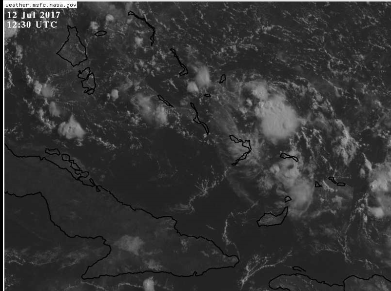
tailgater wrote:Well the elongated swirl I was watching yesterday has now become a bit more circular with a T-storm almost directly over it. Look at the loop of 73.5W 23.3N. Small but trackabe

Image

Aww, is cute baby storm! :lol:
1 likes   

The Enthusiast
NREMT-AEMT, WX nerd

Irene '11, Sandy '12, Irma '17 (SAR)

"Hard to think we were born to live this way..." -Wage War

User avatar
tailgater
S2K Supporter
S2K Supporter
Posts: 3339
Joined: Sun Jul 11, 2004 9:13 pm
Location: St. Amant La.

Re: ATL: FOUR - Remnants - Discussion

#1244 Postby tailgater » Wed Jul 12, 2017 8:46 am

I don't how to post the Visible loops(computer idiot).
I'm glad that the models aren't doing anything with this in the short term or long term either really but I don't like systems moving through the Fla. straits. I'm sure thousands do and never develop but you remember the bad ones that do.
Plus, not much else to watch on the Atlantic side. :roll:
0 likes   
The following post is NOT an official forecast and should not be used as such. It is just the opinion of the poster and may or may not be backed by sound meteorological data. It is NOT endorsed by any professional institution including storm2k.org For Official Information please refer to the NHC and NWS products.

User avatar
boca
Category 5
Category 5
Posts: 6306
Age: 59
Joined: Mon Dec 15, 2003 8:49 am
Location: Boca Raton,FL

Re: ATL: FOUR - Remnants - Discussion

#1245 Postby boca » Wed Jul 12, 2017 8:50 am

Tailgater 94L is the size of my nail on my pinky finger
0 likes   

User avatar
tropicwatch
Category 5
Category 5
Posts: 3205
Age: 60
Joined: Sat Jun 02, 2007 10:01 am
Location: Panama City Florida
Contact:

Re: ATL: FOUR - Remnants - Discussion

#1246 Postby tropicwatch » Wed Jul 12, 2017 9:37 am

tailgater wrote:I don't how to post the Visible loops(computer idiot).
I'm glad that the models aren't doing anything with this in the short term or long term either really but I don't like systems moving through the Fla. straits. I'm sure thousands do and never develop but you remember the bad ones that do.
Plus, not much else to watch on the Atlantic side. :roll:


Not very impressive.
Image
0 likes   
Tropicwatch


Agnes 72', Eloise 75, Elena 85', Kate 85', Charley 86', Florence 88', Beryl 94', Dean 95', Erin 95', Opal 95', Earl 98', Georges 98', Ivan 2004', Arlene 2005', Dennis 2005', Ida 2009' Debby 2012' Irma 2017' Michael 2018'

psyclone
S2K Supporter
S2K Supporter
Posts: 4487
Joined: Wed Aug 24, 2005 9:04 pm
Location: palm harbor fl

Re: ATL: FOUR - Remnants - Discussion

#1247 Postby psyclone » Wed Jul 12, 2017 9:59 am

PWAT out of Ruskin was only 1.56" but higher octane air will be advancing west later on which should lead to good storm chances on the west coast...especially if we can get a seabreeze...an increasingly tall order when the water temps are in the upper 80's with a moderate east flow. it's definitely been a more thundery Summer interior and west thus far for Florida.
0 likes   

Stormcenter
S2K Supporter
S2K Supporter
Posts: 6617
Joined: Wed Sep 03, 2003 11:27 am
Location: Houston, TX

Re: ATL: FOUR - Remnants - Discussion

#1248 Postby Stormcenter » Wed Jul 12, 2017 10:24 am

I still would not write this off. IMO
0 likes   

User avatar
lrak
S2K Supporter
S2K Supporter
Posts: 1770
Age: 57
Joined: Thu Jun 21, 2007 2:48 pm
Location: Corpus Christi, TX

Re: ATL: FOUR - Remnants - Discussion

#1249 Postby lrak » Wed Jul 12, 2017 10:43 am

Looking better to me also. tailgater may have us all turning our heads tomorrow :double: I haven't seen any outflow boundaries
0 likes   
AKA karl

Also
Personal Forecast Disclaimer:
My posts on this forum are NOT official forecast and should not be used as such. My posts are my basic observations and are definitely not backed by any "well some" meteorological knowledge. For official information, please refer to the NHC and NWS products.

Frank P
S2K Supporter
S2K Supporter
Posts: 2408
Joined: Fri Aug 29, 2003 10:52 am
Location: Biloxi Beach, Ms

Re: ATL: FOUR - Remnants - Discussion

#1250 Postby Frank P » Wed Jul 12, 2017 10:48 am

lrak wrote:Looking better to me also. tailgater may have us all turning our heads tomorrow :double:

yep, and only game in town too.. got a little spin, convection is slowing building up, water temps good, who knows.... certainly heading for the GOM... its like a little Class A minor league wanna be ex TD... trying to make a comeback?
2 likes   

User avatar
wxman57
Moderator-Pro Met
Moderator-Pro Met
Posts: 22480
Age: 66
Joined: Sat Jun 21, 2003 8:06 pm
Location: Houston, TX (southwest)

Re: ATL: FOUR - Remnants - Discussion

#1251 Postby wxman57 » Wed Jul 12, 2017 11:24 am

You guys must be looking at something different than I am. I see a tropical wave moving into the coast of Florida. Pressures are almost 1020mb! There's no circulation, no organized convection, only a wave axis in a relatively high pressure area. Development chances are pretty close to zero. The wave will cause increased thunderstorm activity across south Florida over the next 12-24 hours then move across the northern Gulf and inland along the mid Gulf coast, where it will cause increased shower activity. It has only a slightly better chance of making a comeback than I do in being selected for the All-Star game next July.

Image
2 likes   

User avatar
tropicwatch
Category 5
Category 5
Posts: 3205
Age: 60
Joined: Sat Jun 02, 2007 10:01 am
Location: Panama City Florida
Contact:

Re: ATL: FOUR - Remnants - Discussion

#1252 Postby tropicwatch » Wed Jul 12, 2017 11:28 am

We are looking at the area that is in the vicinity that the NHC had it at 6:50am edt.

The remnants of T.D. Four continue situated in the SW N Atlc
waters while it further weakens. A 1015 mb low pressure is
associated with it, which is located near 22N71W along with a
surface trough that extends from 25N71W to the low to 20N71W.
1 likes   
Tropicwatch


Agnes 72', Eloise 75, Elena 85', Kate 85', Charley 86', Florence 88', Beryl 94', Dean 95', Erin 95', Opal 95', Earl 98', Georges 98', Ivan 2004', Arlene 2005', Dennis 2005', Ida 2009' Debby 2012' Irma 2017' Michael 2018'

Stormcenter
S2K Supporter
S2K Supporter
Posts: 6617
Joined: Wed Sep 03, 2003 11:27 am
Location: Houston, TX

Re: ATL: FOUR - Remnants - Discussion

#1253 Postby Stormcenter » Wed Jul 12, 2017 11:33 am

You better start practicing your swing then. :lol:

wxman57 wrote:You guys must be looking at something different than I am. I see a tropical wave moving into the coast of Florida. Pressures are almost 1020mb! There's no circulation, no organized convection, only a wave axis in a relatively high pressure area. Development chances are pretty close to zero. The wave will cause increased thunderstorm activity across south Florida over the next 12-24 hours then move across the northern Gulf and inland along the mid Gulf coast, where it will cause increased shower activity. It has only a slightly better chance of making a comeback than I do in being selected for the All-Star game next July.

http://wxman57.com/images/4f.JPG
3 likes   

User avatar
AdamFirst
S2K Supporter
S2K Supporter
Posts: 2487
Age: 34
Joined: Thu Aug 14, 2008 10:54 am
Location: Port Saint Lucie, FL

Re: ATL: FOUR - Remnants - Discussion

#1254 Postby AdamFirst » Wed Jul 12, 2017 11:33 am

My area's getting training showers and storms as the northern have of the wave axis pushes onto the coast. Most rain we've gotten down here in a week or two.
0 likes   
Dolphins Marlins Canes Golden Panthers HEAT
Andrew 1992 - Irene 1999 - Frances 2004 - Jeanne 2004 - Wilma 2005 - Fay 2008 - Isaac 2012 - Matthew 2016 - Irma 2017 - Dorian 2019 - Ian 2022 - Nicole 2022

User avatar
wxman57
Moderator-Pro Met
Moderator-Pro Met
Posts: 22480
Age: 66
Joined: Sat Jun 21, 2003 8:06 pm
Location: Houston, TX (southwest)

Re: ATL: FOUR - Remnants - Discussion

#1255 Postby wxman57 » Wed Jul 12, 2017 11:36 am

panamatropicwatch wrote:We are looking at the area that is in the vicinity that the NHC had it at 6:50am edt.

The remnants of T.D. Four continue situated in the SW N Atlc
waters while it further weakens. A 1015 mb low pressure is
associated with it, which is located near 22N71W along with a
surface trough that extends from 25N71W to the low to 20N71W.


There's nothing there. Certainly no 1015mb low center - pressures are 1019-1020mb in the region they mention. The wave is approaching the coast of Florida. You can see it clearly in the TPW loop moving into the coast of Florida.

Image
0 likes   

User avatar
tropicwatch
Category 5
Category 5
Posts: 3205
Age: 60
Joined: Sat Jun 02, 2007 10:01 am
Location: Panama City Florida
Contact:

Re: ATL: FOUR - Remnants - Discussion

#1256 Postby tropicwatch » Wed Jul 12, 2017 11:43 am

Don't know what to say wxman57 that is what was in this mornings TWD. The current vorticity map makes it look like something there also. Unless it traveled a couple hundred miles in 6 hours.

Image
0 likes   
Tropicwatch


Agnes 72', Eloise 75, Elena 85', Kate 85', Charley 86', Florence 88', Beryl 94', Dean 95', Erin 95', Opal 95', Earl 98', Georges 98', Ivan 2004', Arlene 2005', Dennis 2005', Ida 2009' Debby 2012' Irma 2017' Michael 2018'

User avatar
GCANE
S2K Supporter
S2K Supporter
Posts: 10787
Joined: Mon Oct 22, 2007 8:03 am

Re: ATL: FOUR - Remnants - Discussion

#1257 Postby GCANE » Wed Jul 12, 2017 11:54 am

Air is very juiced around FL.
5500 CAPE east of Miami.
Over land, nearly completely saturated surface to tropopause.
Relatively decent Theta-E ridge in the east GOM.

Thuderstorms over FL should explode this afternoon.

Who knows.
If this runs thru the Straits with LL Vort intact, 355K PV forecast is showing an opportunity to vertically expand when or if it gets into the GOM.
2 likes   

User avatar
AJC3
Admin
Admin
Posts: 3868
Age: 60
Joined: Tue Aug 31, 2004 7:04 pm
Location: West Melbourne, Florida
Contact:

Re: ATL: FOUR - Remnants - Discussion

#1258 Postby AJC3 » Wed Jul 12, 2017 1:40 pm

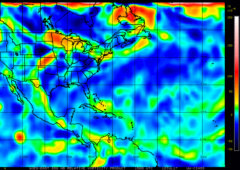
panamatropicwatch wrote:Don't know what to say wxman57 that is what was in this mornings TWD. The current vorticity map makes it look like something there also. Unless it traveled a couple hundred miles in 6 hours.


Keep in mind that the 650 AM TWD was based off the surface analysis at 06Z/200 AM EDT. That was about 10 hours before your post, so there was some serious time lag going on there.

Another thing to keep in mind is that the H85-H70 vort lobe associated with this wave got horribly deformed. While the leading edge of the wave is crossing south Florida, a significant vort axis extends ESE from near Andros Island to north of Hispanola. This wave looks like it has split in two.
2 likes   

User avatar
Blown Away
S2K Supporter
S2K Supporter
Posts: 9861
Joined: Wed May 26, 2004 6:17 am

Re: ATL: FOUR - Remnants - Discussion

#1259 Postby Blown Away » Wed Jul 12, 2017 1:52 pm

Serious squally tropical weather all day from former TD4... Seems like a very long time since we've had a true westward moving tropical wave pass through. BH seems stronger this year, maybe I'm wrong...
1 likes   
Hurricane Eye Experience: David 79, Irene 99, Frances 04, Jeanne 04, Wilma 05...
Hurricane Brush Experience: Andrew 92, Erin 95, Floyd 99, Matthew 16, Irma 17, Ian 22, Nicole 22…

User avatar
wxman57
Moderator-Pro Met
Moderator-Pro Met
Posts: 22480
Age: 66
Joined: Sat Jun 21, 2003 8:06 pm
Location: Houston, TX (southwest)

Re: ATL: FOUR - Remnants - Discussion

#1260 Postby wxman57 » Wed Jul 12, 2017 1:54 pm

Currently, the wave axis can be clearly seen in the surface obs across Florida. Former TD 4 is causing quite a few storms across the southern Florida Peninsula this afternoon.

Image
2 likes   


Return to “2017”

Who is online

Users browsing this forum: No registered users and 38 guests