000
WTPZ45 KNHC 102034
TCDEP5
Hurricane Eugene Discussion Number 13
NWS National Hurricane Center Miami FL EP052017
200 PM PDT Mon Jul 10 2017
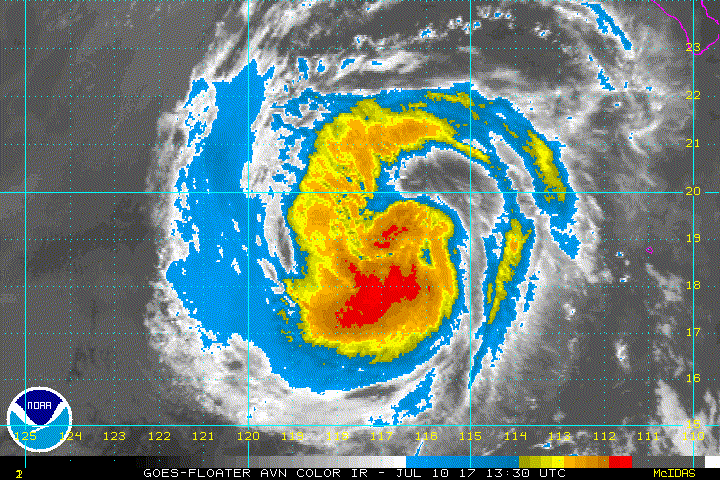
Eugene's convective presentation has continued to wane significantly
during the past six hours. Cloud tops near the center have warmed
to barely -65C and the overall cloud pattern has become elongated
northwest-to-southeast. The initial intensity has been lowered to
65 kt based on a blend of satellite intensity estimates from TAFB
and SAB.
There are no significant changes to the previous track and intensity
forecasts or reasonings. Eugene is expected to continue to move in a
general northwestward direction throughout the forecast period, and
steadily or rapidly weaken while moving over much colder waters
characterized by 25C-22C SSTs. The track and intensity forecasts
closely follow the TVCN and IVCN consensus models, respectively.
Swells generated by Eugene will propagate northward along the west
coast of the Baja California peninsula to southern California during
the next few days, causing high surf and dangerous rip current
conditions. Please refer to advisories issued by your local weather
office for additional information.
FORECAST POSITIONS AND MAX WINDS
INIT 10/2100Z 19.4N 117.8W 65 KT 75 MPH
12H 11/0600Z 20.6N 118.6W 55 KT 65 MPH
24H 11/1800Z 22.1N 119.7W 45 KT 50 MPH
36H 12/0600Z 23.4N 120.6W 35 KT 40 MPH...POST-TROPICAL
48H 12/1800Z 24.6N 121.5W 25 KT 30 MPH...POST-TROP/REMNT LOW
72H 13/1800Z 26.7N 123.1W 20 KT 25 MPH...POST-TROP/REMNT LOW
96H 14/1800Z 28.3N 124.4W 15 KT 15 MPH...POST-TROP/REMNT LOW
120H 15/1800Z 29.5N 127.0W 15 KT 15 MPH...POST-TROP/REMNT LOW
$$
Forecaster Stewart
EPAC: EUGENE - Post-Tropical
Moderator: S2k Moderators
-
Sciencerocks
- Category 5

- Posts: 7282
- Age: 38
- Joined: Thu Jul 06, 2017 1:51 am
Re: EPAC: EUGENE - Hurricane
0 likes
-
Sciencerocks
- Category 5
- Posts: 7282
- Age: 38
- Joined: Thu Jul 06, 2017 1:51 am
-
Kingarabian

- S2K Supporter

- Posts: 15432
- Joined: Sat Aug 08, 2009 3:06 am
- Location: Honolulu, Hawaii
-
1900hurricane

- Category 5
- Posts: 6044
- Age: 32
- Joined: Fri Feb 06, 2015 12:04 pm
- Location: Houston, TX
- Contact:
Re: EPAC: EUGENE - Hurricane
The degrading structure is actually kinda cool to look at on visible imagery.

3 likes
Contract Meteorologist. TAMU & MSST. Fiercely authentic, one of a kind. We are all given free will, so choose a life meant to be lived. We are the Masters of our own Stories.
Opinions expressed are mine alone.
Follow me on Twitter at @1900hurricane : Read blogs at https://1900hurricane.wordpress.com/
Opinions expressed are mine alone.
Follow me on Twitter at @1900hurricane : Read blogs at https://1900hurricane.wordpress.com/
-
Sciencerocks
- Category 5
- Posts: 7282
- Age: 38
- Joined: Thu Jul 06, 2017 1:51 am
Re: EPAC: EUGENE - Tropical Storm
ZCZC MIATCDEP5 ALL
TTAA00 KNHC DDHHMM
Tropical Storm Eugene Discussion Number 14
NWS National Hurricane Center Miami FL EP052017
800 PM PDT Mon Jul 10 2017
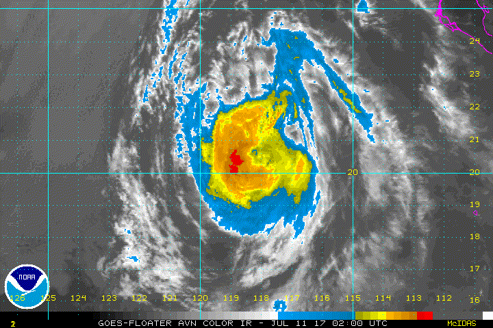
Eugene continues to weaken as it traverses SSTs below 26 deg C.
The central deep convection is gradually becoming eroded, and the
current intensity is estimated at 60 kt which is the mean of Dvorak
CI numbers from SAB and TAFB. Although the storm continues to
exhibit a fairly symmetrical upper-level outflow structure, it will
be moving over increasingly cooler waters for the next few days.
Continued weakening is likely, and the official intensity forecast
is very close to the latest model consensus. Eugene should
degenerate into a remnant low by Wednesday morning.
The motion remains near 325/9. There are no important changes to
the track forecast reasoning. A mid-level anticyclone to the
northeast of Eugene should maintain a generally northwestward
heading for the next few days, and until dissipation. A slight
leftward bend is likely in a couple of days while the weakening
cyclone becomes steered more by the low-level flow. The official
forecast track is close to the latest corrected consensus
prediction.
Swells generated by Eugene will propagate northward along the west
coast of the Baja California peninsula to southern California during
the next few days, causing high surf and dangerous rip current
conditions. Please refer to statements issued by your local weather
office for additional information.
FORECAST POSITIONS AND MAX WINDS
INIT 11/0300Z 20.2N 118.2W 60 KT 70 MPH
12H 11/1200Z 21.3N 119.1W 50 KT 60 MPH
24H 12/0000Z 22.6N 120.1W 40 KT 45 MPH
36H 12/1200Z 23.8N 121.0W 30 KT 35 MPH...POST-TROP/REMNT LOW
48H 13/0000Z 24.9N 122.1W 25 KT 30 MPH...POST-TROP/REMNT LOW
72H 14/0000Z 26.8N 124.1W 20 KT 25 MPH...POST-TROP/REMNT LOW
96H 15/0000Z 28.0N 125.5W 20 KT 25 MPH...POST-TROP/REMNT LOW
120H 16/0000Z...DISSIPATED
$$
Forecaster Pasch
NNNN
TTAA00 KNHC DDHHMM
Tropical Storm Eugene Discussion Number 14
NWS National Hurricane Center Miami FL EP052017
800 PM PDT Mon Jul 10 2017
Eugene continues to weaken as it traverses SSTs below 26 deg C.
The central deep convection is gradually becoming eroded, and the
current intensity is estimated at 60 kt which is the mean of Dvorak
CI numbers from SAB and TAFB. Although the storm continues to
exhibit a fairly symmetrical upper-level outflow structure, it will
be moving over increasingly cooler waters for the next few days.
Continued weakening is likely, and the official intensity forecast
is very close to the latest model consensus. Eugene should
degenerate into a remnant low by Wednesday morning.
The motion remains near 325/9. There are no important changes to
the track forecast reasoning. A mid-level anticyclone to the
northeast of Eugene should maintain a generally northwestward
heading for the next few days, and until dissipation. A slight
leftward bend is likely in a couple of days while the weakening
cyclone becomes steered more by the low-level flow. The official
forecast track is close to the latest corrected consensus
prediction.
Swells generated by Eugene will propagate northward along the west
coast of the Baja California peninsula to southern California during
the next few days, causing high surf and dangerous rip current
conditions. Please refer to statements issued by your local weather
office for additional information.
FORECAST POSITIONS AND MAX WINDS
INIT 11/0300Z 20.2N 118.2W 60 KT 70 MPH
12H 11/1200Z 21.3N 119.1W 50 KT 60 MPH
24H 12/0000Z 22.6N 120.1W 40 KT 45 MPH
36H 12/1200Z 23.8N 121.0W 30 KT 35 MPH...POST-TROP/REMNT LOW
48H 13/0000Z 24.9N 122.1W 25 KT 30 MPH...POST-TROP/REMNT LOW
72H 14/0000Z 26.8N 124.1W 20 KT 25 MPH...POST-TROP/REMNT LOW
96H 15/0000Z 28.0N 125.5W 20 KT 25 MPH...POST-TROP/REMNT LOW
120H 16/0000Z...DISSIPATED
$$
Forecaster Pasch
NNNN
0 likes
-
Hurricaneman

- Category 5
- Posts: 7280
- Age: 43
- Joined: Tue Aug 31, 2004 3:24 pm
- Location: central florida
Re: EPAC: EUGENE - Tropical Storm
I like how in systems like this that get over cooler water how the convection dissipates and reveals the surface structure of the tropical cyclone
0 likes
-
Sciencerocks
- Category 5
- Posts: 7282
- Age: 38
- Joined: Thu Jul 06, 2017 1:51 am
Re: EPAC: EUGENE - Tropical Storm
000
WTPZ45 KNHC 110836
TCDEP5
Tropical Storm Eugene Discussion Number 15
NWS National Hurricane Center Miami FL EP052017
200 AM PDT Tue Jul 11 2017
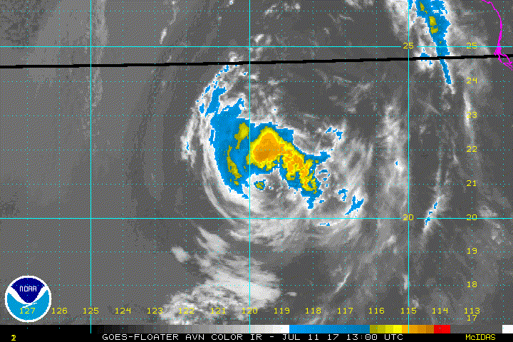
The areal coverage of cold cloud tops continues to decrease, and
microwave images indicate that all the remaining deep convection is
restricted to the northwestern quadrant. Based on a blend of the
latest subjective and objective Dvorak final-T and CI numbers,
Eugene is estimated to have maximum winds of 55 kt. With sea
surface temperatures decreasing below 22 deg C ahead of Eugene, the
cyclone's winds and convection will continue to wane, and it will
likely degenerate into a remnant low by 36 hours. Based on the
global models, the remnant low should dissipate by day 5.
Eugene remains on a steady northwestward heading of 325/8 kt.
Little change in this trajectory is expected during the next
several days as Eugene moves toward a break in the subtropical
ridge located off the northern Baja California coast. Some
reduction in forward speed is likely by day 3 and 4 when the
remnant low is steered by weaker low-level winds. The updated NHC
track forecast is very close to the TVCN multi-model consensus and
is not too different from the previous forecast.
Swells generated by Eugene will continue to propagate northward
along the west coast of the Baja California peninsula to southern
California during the next few days, causing high surf and dangerous
rip current conditions. Please refer to statements issued by your
local weather office for additional information.
FORECAST POSITIONS AND MAX WINDS
INIT 11/0900Z 20.6N 118.7W 55 KT 65 MPH
12H 11/1800Z 21.6N 119.5W 45 KT 50 MPH
24H 12/0600Z 22.8N 120.5W 35 KT 40 MPH
36H 12/1800Z 24.0N 121.6W 30 KT 35 MPH...POST-TROP/REMNT LOW
48H 13/0600Z 25.2N 122.7W 25 KT 30 MPH...POST-TROP/REMNT LOW
72H 14/0600Z 27.1N 124.6W 20 KT 25 MPH...POST-TROP/REMNT LOW
96H 15/0600Z 28.5N 126.0W 20 KT 25 MPH...POST-TROP/REMNT LOW
120H 16/0600Z...DISSIPATED
$$
Forecaster Berg
WTPZ45 KNHC 110836
TCDEP5
Tropical Storm Eugene Discussion Number 15
NWS National Hurricane Center Miami FL EP052017
200 AM PDT Tue Jul 11 2017
The areal coverage of cold cloud tops continues to decrease, and
microwave images indicate that all the remaining deep convection is
restricted to the northwestern quadrant. Based on a blend of the
latest subjective and objective Dvorak final-T and CI numbers,
Eugene is estimated to have maximum winds of 55 kt. With sea
surface temperatures decreasing below 22 deg C ahead of Eugene, the
cyclone's winds and convection will continue to wane, and it will
likely degenerate into a remnant low by 36 hours. Based on the
global models, the remnant low should dissipate by day 5.
Eugene remains on a steady northwestward heading of 325/8 kt.
Little change in this trajectory is expected during the next
several days as Eugene moves toward a break in the subtropical
ridge located off the northern Baja California coast. Some
reduction in forward speed is likely by day 3 and 4 when the
remnant low is steered by weaker low-level winds. The updated NHC
track forecast is very close to the TVCN multi-model consensus and
is not too different from the previous forecast.
Swells generated by Eugene will continue to propagate northward
along the west coast of the Baja California peninsula to southern
California during the next few days, causing high surf and dangerous
rip current conditions. Please refer to statements issued by your
local weather office for additional information.
FORECAST POSITIONS AND MAX WINDS
INIT 11/0900Z 20.6N 118.7W 55 KT 65 MPH
12H 11/1800Z 21.6N 119.5W 45 KT 50 MPH
24H 12/0600Z 22.8N 120.5W 35 KT 40 MPH
36H 12/1800Z 24.0N 121.6W 30 KT 35 MPH...POST-TROP/REMNT LOW
48H 13/0600Z 25.2N 122.7W 25 KT 30 MPH...POST-TROP/REMNT LOW
72H 14/0600Z 27.1N 124.6W 20 KT 25 MPH...POST-TROP/REMNT LOW
96H 15/0600Z 28.5N 126.0W 20 KT 25 MPH...POST-TROP/REMNT LOW
120H 16/0600Z...DISSIPATED
$$
Forecaster Berg
0 likes
-
Sciencerocks
- Category 5
- Posts: 7282
- Age: 38
- Joined: Thu Jul 06, 2017 1:51 am
-
cycloneye

- Admin

- Posts: 139019
- Age: 67
- Joined: Thu Oct 10, 2002 10:54 am
- Location: San Juan, Puerto Rico
Re: EPAC: EUGENE - Tropical Storm
Tropical Storm Eugene Discussion Number 16
NWS National Hurricane Center Miami FL EP052017
800 AM PDT Tue Jul 11 2017
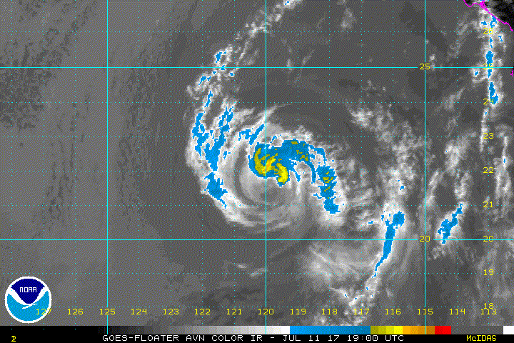
Deep convection associated with Eugene is diminishing in depth and
areal coverage. Consequently, subjective Dvorak estimates from SAB
and TAFB as well as objective ADT values from CIMSS continue to
drop. The initial intensity is set at 45 kt, though this is with a
substantial amount of uncertainty.
A 0949Z AMSR2 microwave image helped to locate the center of Eugene
this morning. The system is moving toward the northwest at about 9
kt. Eugene is expected to continue moving in the same direction
and speed for the next couple of days, as it is rounding the
southwestern portion of a mid-level subtropical ridge. The
official track forecast is nearly unchanged and continues to be
based upon the multi-model consensus technique TVCN.
Eugene has been weakening due to ingestion of cool and dry air as
it moves into the stratocumulus-infested waters west of Baja
California. This will continue due to the northwestward track over
even cooler SSTs during the next two days. It is expected that
Eugene will lose its deep convection and become a remnant low in
24-36 hr and dissipate completely in about 5 days. The official
intensity forecast is slightly lower than that previously and is
based upon the multi-model consensus technique IVCN.
Swells generated by Eugene will continue to propagate northward
along the west coast of the Baja California peninsula to southern
California during the next couple days, causing high surf and
dangerous rip current conditions. Please refer to statements issued
by your local weather office for additional information.
FORECAST POSITIONS AND MAX WINDS
INIT 11/1500Z 21.3N 119.6W 45 KT 50 MPH
12H 12/0000Z 22.3N 120.4W 35 KT 40 MPH
24H 12/1200Z 23.4N 121.2W 30 KT 35 MPH
36H 13/0000Z 24.6N 122.2W 25 KT 30 MPH...POST-TROP/REMNT LOW
48H 13/1200Z 25.7N 123.3W 25 KT 30 MPH...POST-TROP/REMNT LOW
72H 14/1200Z 27.6N 124.9W 20 KT 25 MPH...POST-TROP/REMNT LOW
96H 15/1200Z 28.8N 126.0W 20 KT 25 MPH...POST-TROP/REMNT LOW
120H 16/1200Z...DISSIPATED
$$
Forecaster Landsea
NWS National Hurricane Center Miami FL EP052017
800 AM PDT Tue Jul 11 2017
Deep convection associated with Eugene is diminishing in depth and
areal coverage. Consequently, subjective Dvorak estimates from SAB
and TAFB as well as objective ADT values from CIMSS continue to
drop. The initial intensity is set at 45 kt, though this is with a
substantial amount of uncertainty.
A 0949Z AMSR2 microwave image helped to locate the center of Eugene
this morning. The system is moving toward the northwest at about 9
kt. Eugene is expected to continue moving in the same direction
and speed for the next couple of days, as it is rounding the
southwestern portion of a mid-level subtropical ridge. The
official track forecast is nearly unchanged and continues to be
based upon the multi-model consensus technique TVCN.
Eugene has been weakening due to ingestion of cool and dry air as
it moves into the stratocumulus-infested waters west of Baja
California. This will continue due to the northwestward track over
even cooler SSTs during the next two days. It is expected that
Eugene will lose its deep convection and become a remnant low in
24-36 hr and dissipate completely in about 5 days. The official
intensity forecast is slightly lower than that previously and is
based upon the multi-model consensus technique IVCN.
Swells generated by Eugene will continue to propagate northward
along the west coast of the Baja California peninsula to southern
California during the next couple days, causing high surf and
dangerous rip current conditions. Please refer to statements issued
by your local weather office for additional information.
FORECAST POSITIONS AND MAX WINDS
INIT 11/1500Z 21.3N 119.6W 45 KT 50 MPH
12H 12/0000Z 22.3N 120.4W 35 KT 40 MPH
24H 12/1200Z 23.4N 121.2W 30 KT 35 MPH
36H 13/0000Z 24.6N 122.2W 25 KT 30 MPH...POST-TROP/REMNT LOW
48H 13/1200Z 25.7N 123.3W 25 KT 30 MPH...POST-TROP/REMNT LOW
72H 14/1200Z 27.6N 124.9W 20 KT 25 MPH...POST-TROP/REMNT LOW
96H 15/1200Z 28.8N 126.0W 20 KT 25 MPH...POST-TROP/REMNT LOW
120H 16/1200Z...DISSIPATED
$$
Forecaster Landsea
0 likes
Visit the Caribbean-Central America Weather Thread where you can find at first post web cams,radars
and observations from Caribbean basin members Click Here
and observations from Caribbean basin members Click Here
-
Sciencerocks
- Category 5
- Posts: 7282
- Age: 38
- Joined: Thu Jul 06, 2017 1:51 am
-
Sciencerocks
- Category 5
- Posts: 7282
- Age: 38
- Joined: Thu Jul 06, 2017 1:51 am
Re: EPAC: EUGENE - Tropical Storm
ZCZC MIATCDEP5 ALL
TTAA00 KNHC DDHHMM
Tropical Storm Eugene Discussion Number 17
NWS National Hurricane Center Miami FL EP052017
200 PM PDT Tue Jul 11 2017
The deep convection associated with Eugene is rapidly waning.
While the Dvorak assessments from ADT, SAB, and TAFB suggest a
low-end tropical storm at this time, an AMSU pass back at 1417Z
generated intensity estimates of around 60 kt from CIRA and CIMSS.
However, it is unlikely that these maximum winds are valid because
of the increased stability over the stratocumulus-blanketed waters.
A blend of the Dvorak and AMSU estimates gives 45 kt for the
initial intensity.
The diminished deep convection and visible imagery allow for a more
accurate determination of Eugene's initial position and motion,
which is northwestward at 8 kt. The tropical cyclone is expected to
continue moving in the same direction and speed for the next couple
of days, as it is rounding the southwestern portion of a mid-level
subtropical ridge. The official track forecast is nearly unchanged
and is based upon the HCCA corrected consensus technique.
Eugene should continue its weakening due to ingestion of stable air
as it moves over the cool waters west of Baja California. It is
expected that the cyclone will lose its deep convection and become
a remnant low in about a day - or sooner - and dissipate completely
in four to five days. The official intensity forecast is the same
as that previously and is based upon the IVCN multi-model consensus
technique.
Swells generated by Eugene will continue to propagate northward
along the west coast of the Baja California peninsula to southern
California during the next couple days, causing high surf and
dangerous rip current conditions. Please refer to statements
issued by your local weather office for additional information.
FORECAST POSITIONS AND MAX WINDS
INIT 11/2100Z 21.7N 120.0W 45 KT 50 MPH
12H 12/0600Z 22.5N 120.8W 35 KT 40 MPH
24H 12/1800Z 23.6N 121.8W 30 KT 35 MPH...POST-TROP/REMNT LOW
36H 13/0600Z 24.7N 122.8W 25 KT 30 MPH...POST-TROP/REMNT LOW
48H 13/1800Z 25.8N 123.8W 25 KT 30 MPH...POST-TROP/REMNT LOW
72H 14/1800Z 27.6N 125.3W 20 KT 25 MPH...POST-TROP/REMNT LOW
96H 15/1800Z 28.5N 126.5W 20 KT 25 MPH...POST-TROP/REMNT LOW
120H 16/1800Z...DISSIPATED
$$
Forecaster Landsea
0 likes

Re: EPAC: EUGENE - Tropical Storm
CSU has Eugene at 7.6 units. So a 7-8 unit finish seems good.
0 likes
The above post and any post by Ntxw is NOT an official forecast and should not be used as such. It is just the opinion of the poster and may or may not be backed by sound meteorological data. It is NOT endorsed by any professional institution including Storm2k. For official information, please refer to NWS products.
Help support Storm2K!

-
Sciencerocks
- Category 5
- Posts: 7282
- Age: 38
- Joined: Thu Jul 06, 2017 1:51 am
Re: EPAC: EUGENE - Tropical Storm
000
WTPZ45 KNHC 120235
TCDEP5
Tropical Storm Eugene Discussion Number 18
NWS National Hurricane Center Miami FL EP052017
800 PM PDT Tue Jul 11 2017
Although deep convection continues to dwindle overall, a narrow
band of deep convection has continued to persist in the northern
semicircle and near the center. As a result, Eugene is being
maintained as a 40-kt sheared tropical cyclone for this advisory
based on recent UW-CIMSS ADT estimates of T2.7/39 kt and the
robust low-level circulation seen in visible satellite imagery.
The initial motion remains northwestward or 320/08 kt. A deep-layer
ridge to the northeast of Eugene is expected to keep the weakening
cyclone on a northwestward track throughout the forecast period,
which will be accompanied by a gradual decrease in forward speed
after 24 hours. The NHC track guidance has shifted to the west, thus
the official forecast has also been shifted to the left of the
previous advisory, similar to a blend of the consensus models TVCN
and HCCA.
Eugene will continue to weaken throughout the next 4 days as a
result of the ingestion of drier and more stable air, and from
moving over colder SSTs of near 20 deg C by 48 hours. The NHC
intensity forecast follows the trend of the previous advisory, which
has Eugene degenerating to a remnant low pressure system by 18-24
hours, and dissipating by 120 hours, if not sooner.
Swells generated by Eugene will continue to propagate northward
along the west coast of the Baja California peninsula to southern
California during the next couple of days, causing dangerous surf
and rip current conditions. Please refer to statements issued by
your local weather office for additional information.
FORECAST POSITIONS AND MAX WINDS
INIT 12/0300Z 22.3N 120.5W 40 KT 45 MPH
12H 12/1200Z 23.1N 121.3W 30 KT 35 MPH
24H 13/0000Z 24.2N 122.5W 25 KT 30 MPH...POST-TROP/REMNT LOW
36H 13/1200Z 25.3N 123.7W 25 KT 30 MPH...POST-TROP/REMNT LOW
48H 14/0000Z 26.2N 124.8W 20 KT 25 MPH...POST-TROP/REMNT LOW
72H 15/0000Z 27.5N 126.8W 20 KT 25 MPH...POST-TROP/REMNT LOW
96H 16/0000Z 28.0N 128.0W 15 KT 15 MPH...POST-TROP/REMNT LOW
120H 17/0000Z...DISSIPATED
$$
Forecaster Stewart
0 likes
-
Sciencerocks
- Category 5
- Posts: 7282
- Age: 38
- Joined: Thu Jul 06, 2017 1:51 am
-
Sciencerocks
- Category 5
- Posts: 7282
- Age: 38
- Joined: Thu Jul 06, 2017 1:51 am
Re: EPAC: EUGENE - Tropical Storm
000
WTPZ45 KNHC 120839
TCDEP5
Tropical Storm Eugene Discussion Number 19
NWS National Hurricane Center Miami FL EP052017
200 AM PDT Wed Jul 12 2017
Eugene is producing minimal deep convection, with only a small
patch of cloud tops colder than -50 deg C north of the center. An
ASCAT pass at 0453 UTC indicated that the cyclone was still
producing 35-40 kt winds at the time. Since Eugene is now over sea
surface temperatures of 22-23 deg C and the circulation continues
to spin down, the advisory intensity is set at 35 kt. Significant
deep convection is unlikely to return given the cold ocean, and
Eugene is therefore expected to degenerate into a remnant low later
today. Maximum winds will also continue to decrease over the next
few days, and the circulation should dissipate by day 4.
Eugene is maintaining a northwestward motion of 320/8 kt, steered by
low- to mid-level high pressure located over the Baja California
peninsula. This ridging is expected to strengthen and shift
westward over the next few days, which should cause the remnant
circulation of Eugene to bend a little more to the west before
dissipation. The updated NHC track forecast is very close to the
TVCN multi-model consensus and not too different from the previous
forecast.
Swells generated by Eugene will continue to affect the west coast of
the Baja California peninsula and southern California during the
next day or two, causing dangerous surf and rip current conditions.
Please refer to statements issued by your local weather office for
additional information.
FORECAST POSITIONS AND MAX WINDS
INIT 12/0900Z 22.9N 121.1W 35 KT 40 MPH
12H 12/1800Z 23.8N 121.9W 30 KT 35 MPH...POST-TROP/REMNT LOW
24H 13/0600Z 24.8N 123.0W 25 KT 30 MPH...POST-TROP/REMNT LOW
36H 13/1800Z 25.8N 124.2W 20 KT 25 MPH...POST-TROP/REMNT LOW
48H 14/0600Z 26.7N 125.4W 20 KT 25 MPH...POST-TROP/REMNT LOW
72H 15/0600Z 28.0N 127.5W 15 KT 15 MPH...POST-TROP/REMNT LOW
96H 16/0600Z...DISSIPATED
$$
Forecaster Berg
0 likes
-
cycloneye
- Admin
- Posts: 139019
- Age: 67
- Joined: Thu Oct 10, 2002 10:54 am
- Location: San Juan, Puerto Rico
Re: EPAC: EUGENE - Tropical Depression
Tropical Depression Eugene Discussion Number 20
NWS National Hurricane Center Miami FL EP052017
800 AM PDT Wed Jul 12 2017
Eugene is not quite ready to quit. Deep convection continues in the
northeastern quadrant of the system, though this is not very deep
nor extensive. Given the spin-down likely occuring since the
overnight ASCAT scatterometer pass as well as the Dvorak
classifications from SAB and TAFB, the intensity is assessed at 30
kt, downgrading Eugene to a tropical depression. The system should
lose deep convection shortly as it moves over 21C SSTs and become a
remnant low by tonight. By day 3 or 4, Eugene's circulation is
likely to open up into a trough. The intensity forecast is
unchanged from the previous advisory.
The tropical depression is moving toward the northwest at 9 kt,
steered around the periphery of a low to mid-level subtropical
ridge over northwestern Mexico. This motion should continue for the
next couple of days, then slow by day 3 before dissipation. The
track forecast is slightly east of the previous advisory at days 2
and 3 and is based upon the TVCN multi-model consensus.
Swells generated by Eugene will continue to affect the west coast of
northern Baja California peninsula and southern California during
the next day or two, causing dangerous surf and rip current
conditions. Please refer to statements issued by your local weather
office for additional information.
FORECAST POSITIONS AND MAX WINDS
INIT 12/1500Z 23.6N 121.8W 30 KT 35 MPH
12H 13/0000Z 24.4N 122.7W 30 KT 35 MPH...POST-TROP/REMNT LOW
24H 13/1200Z 25.5N 123.8W 25 KT 30 MPH...POST-TROP/REMNT LOW
36H 14/0000Z 26.4N 124.9W 25 KT 30 MPH...POST-TROP/REMNT LOW
48H 14/1200Z 27.3N 126.0W 20 KT 25 MPH...POST-TROP/REMNT LOW
72H 15/1200Z 28.5N 127.5W 15 KT 15 MPH...POST-TROP/REMNT LOW
96H 16/1200Z...DISSIPATED
$$
Forecaster Landsea
0 likes
Visit the Caribbean-Central America Weather Thread where you can find at first post web cams,radars
and observations from Caribbean basin members Click Here
and observations from Caribbean basin members Click Here
-
cycloneye
- Admin
- Posts: 139019
- Age: 67
- Joined: Thu Oct 10, 2002 10:54 am
- Location: San Juan, Puerto Rico
Re: EPAC: EUGENE - Tropical Depression
Post-Tropical Cyclone Eugene Discussion Number 21
NWS National Hurricane Center Miami FL EP052017
200 PM PDT Wed Jul 12 2017
Eugene has succumbed to the effects of the cool, dry airmass in
which it has become embedded. Organized deep convection dissipated
earlier today and is unlikely to resume due to the system moving
over progressively colder waters west of Baja California. Thus
Eugene has become a post-tropical cyclone. An 1814Z ASCAT
scatterometer pass measured maximum winds of about 30 kt. These
winds will gradually subside and by day 3 or 4 Eugene's circulation
is likely to open up into a trough.
Eugene's remnant low is moving toward the northwest at 9 kt, steered
around the periphery of a low to mid-level subtropical ridge over
northwestern Mexico. This motion should continue for the next
couple of days, then slow with a turn toward the west-northwest by
day 3. The track forecast is slightly west of the previous advisory
and is based upon the HCCA corrected consensus technique.
Swells generated by Eugene affecting portions of the west
coast of northern Baja California peninsula and southern California
will be diminishing on Thursday.
FORECAST POSITIONS AND MAX WINDS
INIT 12/2100Z 24.1N 122.5W 30 KT 35 MPH...POST-TROP/REMNT LOW
12H 13/0600Z 24.9N 123.5W 25 KT 30 MPH...POST-TROP/REMNT LOW
24H 13/1800Z 25.9N 124.8W 25 KT 30 MPH...POST-TROP/REMNT LOW
36H 14/0600Z 26.8N 125.9W 20 KT 25 MPH...POST-TROP/REMNT LOW
48H 14/1800Z 27.7N 126.8W 20 KT 25 MPH...POST-TROP/REMNT LOW
72H 15/1800Z 28.5N 128.0W 15 KT 15 MPH...POST-TROP/REMNT LOW
96H 16/1800Z...DISSIPATED
$$
Forecaster Landsea
0 likes
Visit the Caribbean-Central America Weather Thread where you can find at first post web cams,radars
and observations from Caribbean basin members Click Here
and observations from Caribbean basin members Click Here
Who is online
Users browsing this forum: No registered users and 35 guests